All Activity
- Past hour
-
I see what you did, the nothing to see here narrative .
-
what that map actually tells you is that the central part of a country is getting record warmth from this super Niño. not us. and if you’ve been paying attention over the last several months, we’re gonna ride that into winter. See that big red blob? that was us in 2015. not this year. that also tells you that you’re probably not gonna get a 30 inch snowstorm to save your season so you better have a few smaller events
-

Occasional Thoughts on Climate Change
Typhoon Tip replied to donsutherland1's topic in Climate Change
Agreed ... To understand the global perspective does represent certain challenges. haha vastly understated -
Don’t worry forky, you’ll be fine. Although we might have to start a ‘go fund me’ for bail. As always …..

-
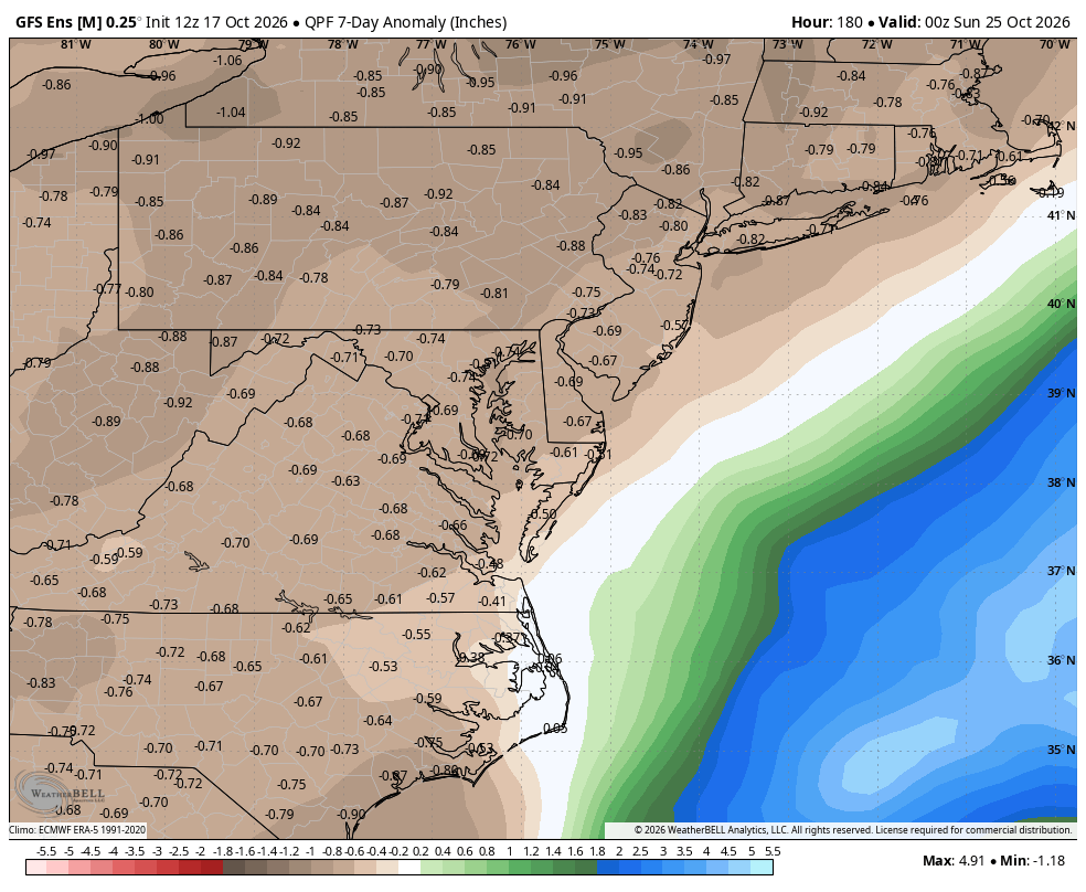
WPC has shifted most of the rainfall off the coast even in areas to our Southeast and South.
-
The college age crew will be rocking those 3 sizes too big hoodies.
-
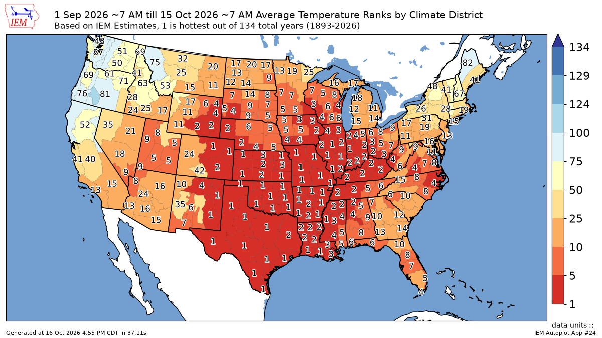
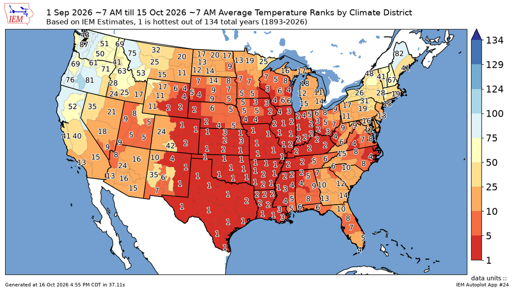
This has been one of the warmest first half's of fall for the entire CONUS. Weather and climate statistics are just pure numbers which didn’t contain any agendas. Most of the area finished up warmer than average in September against the warmest 1991-2020 climate normals. So even relatively low departures can still be ranked fairly high. The smaller warm departures here still rank as the 13th to 15th warmest September 1st to October 15th. This is due to September and October being two of the fastest warming months near 1° per decade since the 1980s. I get it that since this warming has become so thoroughly normalized, most people including yourself probably don’t recognize a warm pattern anymore unless it’s a top 5 or a top 10.
-
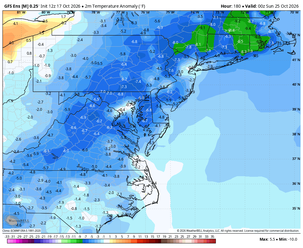
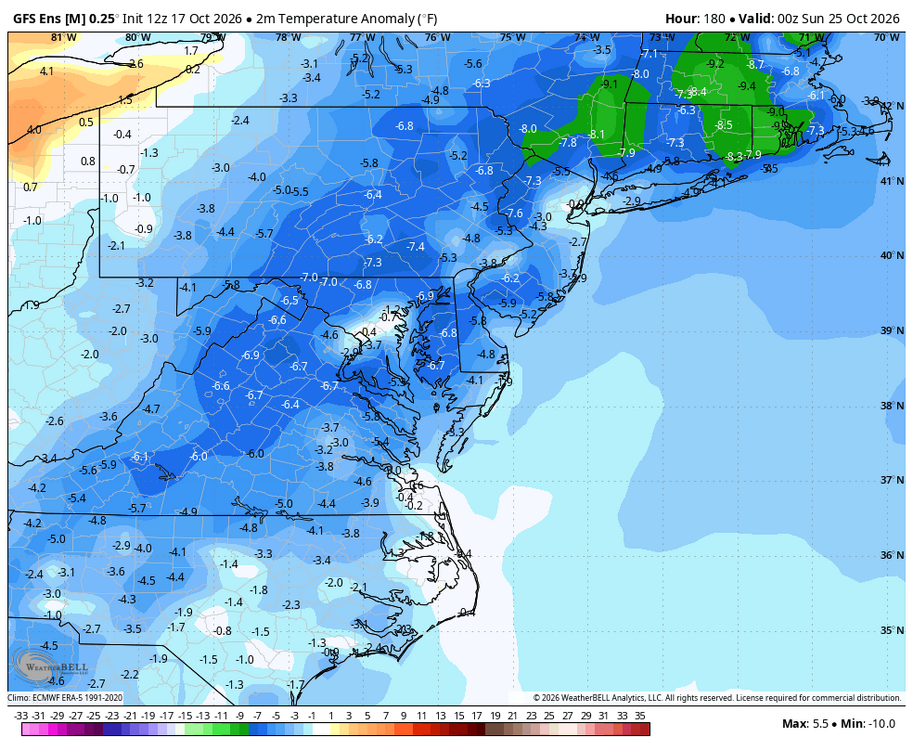
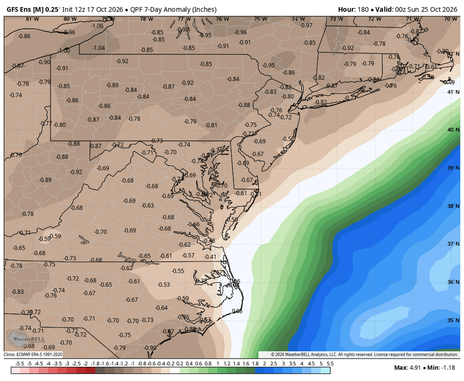
WB 12Z GEFS; looks like the coastal will stay offshore on the latest runs. Cool and dry week ahead for most of us.
-
No surprise there at 2,400'. In town (new Sharon) had a quick downpour at 11 AM, enough to make small puddles and probably some frozen but I was at the Farmington farmers' market with just windy sprinkles.
-

2026-2027 Record-breaking El Nino
GaWx replied to Stormchaserchuck1's topic in Weather Forecasting and Discussion
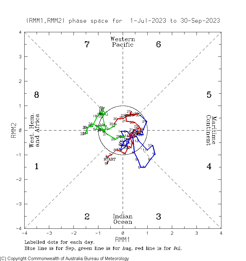
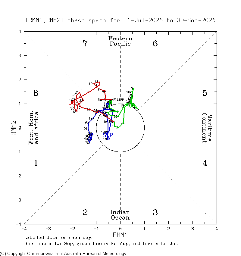
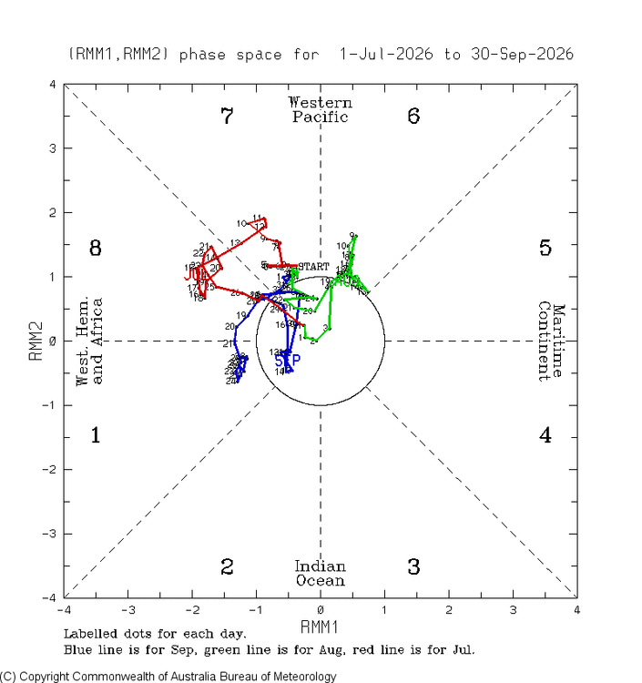
To add to the above, the ‘23 Jul-Sep MJO was much more MC/IO oriented than the nonexistent MC/IO of ‘26: ’23: ‘26: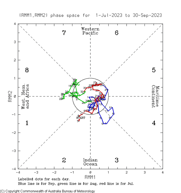
-
2027 or 2028?
-

October 2026 General Discussion
BeastFromTheEast replied to SchaumburgStormer's topic in Lakes/Ohio Valley
next week’s string of upper 60s w/ sun is going to feel like paradise! - Today
-
Doldrums lead to ‘23 FL Keys coral disaster as it wasn’t just due to GW…it was warming of several degrees from the doldrums superimposed on background ocean warming of several degrees due to GW: Sea-surface temperatures in the Coral Sea off northern Queensland often increase during periods known as the "doldrums," characterized by weak winds, reduced cloud cover and dry, descending air. These conditions are unusual for the humid tropics, where we would typically expect plenty of cloud cover, thunderstorms and rainfall.
-
dont disrupt narratives. Bluewave made a BN sept sound like it was a top 10 for warmth. now they are making what looks to be a +1 Oct sound like a sea of record warmth. there are lots of narratives on this website: manufacturing a snowstorm, thunderstorms that would make Dorothy blush, endless warmth, bomb cyclone, polar vortex like we have never seen, manufactured droughts, brush fires made to sound like Yosemite is on fire… the truth is the weather is going to be what it’s going to be. And if you live in NY Metro, its never going to be as extreme as posters would like due to that large ocean next to us and lack of a large mountain chain in a 100 mile radius combined with sea level elevation and a naturally temperate mid atlantic climate. you want a tornado ripping downtown, move to St Louis. you want major hurricanes that destroy normal life for months Tampa. you want a large city with a real winter Chicago. you want endless record Warmth followed by a blizzard in October…Denver or Salt Lake. youre not getting any of that in Queens despite attempts to manufacture it
-
12Z UK: H in N ATL: NEW TROPICAL CYCLONE FORECAST TO DEVELOP AFTER 36 HOURS FORECAST POSITION AT T+ 36 : 32.7N 70.7W LEAD CENTRAL MAXIMUM WIND VERIFYING TIME TIME POSITION PRESSURE (MB) SPEED (KNOTS) -------------- ---- -------- ------------- ------------- 0000UTC 19.10.2026 36 32.7N 70.7W 1007 44 1200UTC 19.10.2026 48 33.7N 71.3W 1004 43 0000UTC 20.10.2026 60 35.0N 71.2W 1002 41 1200UTC 20.10.2026 72 36.0N 70.5W 1001 39 0000UTC 21.10.2026 84 36.0N 70.0W 1001 45 1200UTC 21.10.2026 96 36.0N 70.2W 998 42 0000UTC 22.10.2026 108 36.2N 70.5W 996 45 1200UTC 22.10.2026 120 36.9N 69.2W 992 42 0000UTC 23.10.2026 132 38.1N 66.5W 987 48 1200UTC 23.10.2026 144 40.9N 61.1W 978 67 0000UTC 24.10.2026 156 45.8N 56.8W 977 55 1200UTC 24.10.2026 168 47.9N 58.0W 996 43
-
Occasional Thoughts on Climate Change
Typhoon Tip replied to donsutherland1's topic in Climate Change
speak of the devil... interesting for objective readers/learners: https://phys.org/news/2026-10-el-nio-storm-weather-disaster.html -

E PA/NJ/DE Autumn 2026 Obs/Discussion
JTA66 replied to PhiEaglesfan712's topic in Philadelphia Region
It would be nice to get a frost overnight. Got a mow in today. I feel like I’ve been mowing every weekend since mid April. Anything that can slow down/stop the growing season is greatly appreciated. 50F/DP 36F -
You may not hit 32 until January
-
2026-2027 Record-breaking El Nino
GaWx replied to Stormchaserchuck1's topic in Weather Forecasting and Discussion
Nothing’s even close to a certainty. 2026 and 2023 are not even close in magnitude and 2023 never even got stronger than high end moderate as well as being way less E based in winter (close to basin-wide) vs where 26-7 is heading: these are the official relative anoms: 1+2 3 4 3.4 2023 9 2.27 1.51 0.45 0.91 2026 9 3.94 2.97 -0.02 2.06 2023 12 0.68 1.48 0.73 1.38 2024 1 -0.02 1.15 0.70 1.03 2024 2 0.16 0.78 0.50 0.84 Also, 2026’s PDO is much less negative than 2023’s: 2023 -1.24 -1.79 -2.50 -3.13 -2.46 -2.67 -2.44 -2.02 -2.52 -1.88 -1.16 -1.20 2024 -1.48 -1.33 -1.27 2026 -0.87 -0.79 -1.18 -1.28 -1.64 -1.32 -1.35 -1.12 -0.74 -
Ryan Kane @ryankanerWX https://x.com/ryankanerWX/status/2111481037033296266/photo/1 The latest Euro weeklies run with the troughiness over the western US slowly pushing westward into the pacific makes sense to me. This would allow a more poleward flow at times into CONUS, increasing the chances for cold air intrusions for mid-late November. For now the cold likely stays bottled up through early November. A more typical, strong +ENSO pattern is beginning to take shape come November into December. For snow lovers across the Mid-Atlantic & Northeast, this will be a high boom/bust winter which will all be determined from Jan 15-Feb 15th. I'll have my full synopsis in my winter forecast on Sunday, November 1st. #EcWx #MdWx
-
Height of Land was pounding pretty good earlier Sent from my SM-S921U using Tapatalk
-

2026-2027 Record-breaking El Nino
ensonerd1233e343 replied to Stormchaserchuck1's topic in Weather Forecasting and Discussion
My point is just because it overshot cold in 2023 doesnt mean it will do it this year -
2026-2027 Record-breaking El Nino
ensonerd1233e343 replied to Stormchaserchuck1's topic in Weather Forecasting and Discussion
Right and how did the euro do in 24-25 an 25-26? Its not overhoting cold by that much -
53 and .88 rain.
-
 http://mexgetrx.com/# mexican pharmacy for hair loss pills