All Activity
- Past hour
-

Winter 2025-26 Short Range Discussion
AWMT30 replied to SchaumburgStormer's topic in Lakes/Ohio Valley
Yeah we did do well here in Canton with 5.5" -

First Legit Storm Potential of the Season Upon Us
moneypitmike replied to 40/70 Benchmark's topic in New England
This might not be especially friendly to Southcoast with p-type. Shocker. -
6z NAM tries to pull us back in
- Today
-
 Most recently exemplified by this imminent showdown for Jan 18 where AI-GFS has been consistently and substantially more impactful than legacy GFS… …which is correct TBD... and because lots of people are interested in this topic, I thought I’d start a thread to encompass general debates, updates, and verification tally of AI vs. legacy non-AI / physics-based forecasting guidance. AI forecasting guidance has become operational and easily accessible in the past year. This feels like the first winter we are routinely considering these solutions. Some things this thread can encompass: • rolling tally of AI vs. non-AI performance • situations where AI does better / worse • news of model upgrades and rollouts • Ex Machina “You shouldn’t feel sorry for her. Feel sorry for yourself.” reflection: Do we want perfect AI guidance? So much of the joy in this hobby / profession is the suspense of uncertainty, dissecting vorticity and trends and pattern recognition, the thrill of the chase leading up to a storm that sometimes matches the actual storm. Will we lose this as AI improves? I summarized some relevant information here (yes, ironically with the help of ChatGPT). Major models today: • ECMWF AIFS (Artificial Intelligence Forecasting System) - Became operational early 2025, running alongside the traditional ECMWF - Supposed to be very fast and computationally cheap relative to ECMWF - Recently updated to incorporate “ physical consistency constraints through bounding layers, an updated training schedule, and an expanded set of variables”: https://arxiv.org/abs/2509.18994 • AIGFS (NOAA / experimental guidance) • GraphCast (Google DeepMind) - Claim skill competitive with global models at medium range: https://www.science.org/stoken/author-tokens/ST-1550/full) https://deepmind.google/blog/graphcast-ai-model-for-faster-and-more-accurate-global-weather-forecasting/ • FourCastNet (NVIDIA) https://build.nvidia.com/nvidia/fourcastnet/modelcard What’s driving the rollout? • Speed - AI global forecasts run in seconds to minutes, not hours • Cost & compute efficiency - Orders of magnitude cheaper than traditional NWP - Lower barrier for ensembles, re-runs, sensitivity testing • An arms race --- @Typhoon Tip articulated this nicely in the Jan 18 storm thread - ECMWF, NOAA, tech companies—everyone wants to be first (or not be left behind) • Decent skill at medium range - AI models are particularly strong at large-scale pattern evolution (trough/ridge placement, TC tracks, etc.) How have they performed so far? Strengths • Synoptic pattern recognition in mid-range, like days 3–7 • TC track forecasts • Consistency run-to-run (less chaotic noise) --- we’re seeing this already with AI-GFS / EC for the Jan 18 system Weaknesses 1) QPF magnitude and placement (especially winter storms, and Jan 18 threat might demonstrate this) • AI models often: - Smooth precipitation fields - Struggle with sharp gradients (e.g., coastal fronts, deformation bands) - Miss mesoscale enhancement tied to frontogenesis or CSI • They can produce: - Broad, confident-looking swaths that lack realistic structure --- we’re already seeing this with AI-GFS for Jan 18 - QPF maxima that are too spatially uniform • In winter storms, this shows up as: - Overdone areal coverage of moderate QPF --- again, see Jan 18 where this may be happening - Underrepresentation of narrow heavy bands - Difficulty separating rain/snow/ice impacts 2) Mesoscale & convective-scale processes: • AI models excel at large-scale pattern evolution, but:they do not explicitly resolve: - Convection initiation - Storm-scale feedbacks - Boundary interactions (outflows, lake effects, terrain-driven circulations) • As a result: - Severe weather ingredients can be misrepresented - Convective QPF tends to be overly smeared - Lake-effect and terrain-enhanced precipitation is inconsistent So, AI global models can look great at Day 5 synoptics but shaky inside Day 2–3 details. 3) Sensitivity to initial-condition uncertainty: AI models less good at knife-edge marginal setups where small differences have big impacts. 4) What’s behind the curtain is nebulous and not physically intuitive: When a physics model is wrong, you can often diagnose why (e.g. poor phasing, weak cold air damming, overmixed boundary layer) But with AI models: - Errors and biases can be systematic but reasons opaque - Forecasters will not know what to mentally discount This makes them harder to weigh or adjust the way we do with known biases (e.g. NAM is overamped, GFS southeast bias) 5) AI models are not optimized for rare events. They may overly weigh climatology and as a result miss extreme and rare events. What might we expect in the next few years? • Hybrid systems (physics + AI) becoming the norm • Continuous learning: Unlike traditional NWP (which evolves slowly via code and physics algorithm upgrades), AI models can be retrained frequently as new data become available, and incorporate recent busts or rare events more rapidly. Machine learning can incorporate more physics constraints and verification feedback. This theoretically allows self-correction and reduction in biases over time.
-
Way out there, but next weekend looks like a possible SWFE. Those normally favor New England but it’s going to be many days before we start to get a clearer picture of what’s going to happen….
-
SV maps didn't look this good...sfc was warm. I dunno. Doesn't matter...it'll be gone tomm
-

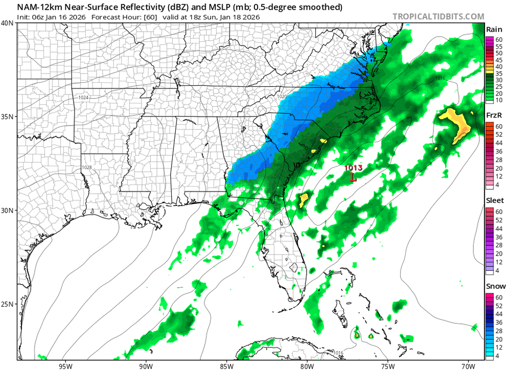
Storm potential January 18th-19th
SI Mailman replied to WeatherGeek2025's topic in New York City Metro
-
EPS very snowy so far
-

First Legit Storm Potential of the Season Upon Us
WxWatcher007 replied to 40/70 Benchmark's topic in New England
Still in it. Some of the models are poised to take a big loss. -

Storm potential January 18th-19th
snowman19 replied to WeatherGeek2025's topic in New York City Metro
You really need to stop this. Stop with the wishcasting and false information/lies. It’s not fair to the members who don’t have access to the models and come on here to get correct info. The EURO is NOT showing 2-3 inches in NYC on Saturday, it barely has over an inch and that’s at 10:1 ratios….the ratios on Saturday are going to be lower than 10:1 -
I’m gonna try to bring an ounce of positivity as I go to bed. Despite the GFS/NAM being stupid and jumping all the way off the storm on today’s runs, a lot of the other data is actually on a steady move west. Canadian and its ensemble, Euro AI, AI GFS and ensemble, and more. As bad as the GFS was at 0z, the GEFS ticked back west. Lastly the Euro itself and its ensemble did as well. I’m not ready to jump off the cliff yet on this one, it’s still too close. Probably won’t happen in the end, but we’ve gotten NW trends of this magnitude inside this timeframe before. Euro AI trend as an example.

-

First Legit Storm Potential of the Season Upon Us
brooklynwx99 replied to 40/70 Benchmark's topic in New England
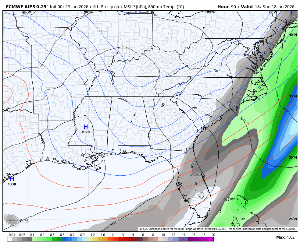
AIFS-ENS with a significant shift west, 0.5” liquid to BOS down to E LI -
Euro has 2 decent snowstorms but we need stronger
-
What you sayin?
-
Euro has a decent snowstorm before the cold from Hell arrives
-

First Legit Storm Potential of the Season Upon Us
weathafella replied to 40/70 Benchmark's topic in New England
AIs remain steadfast. Let’s see what tomorrow brings. -
If you get really cold early it can make it easier for that to happen. Many trees/plants need to go through a certain amount of hours below a threshold and then they're ready to bloom. In 89-90 there was a crazy amount of blooming in VA/NC/SC in mid to late January because everything reached its hours below in December. In a winter like 15-16 that probably did not happen since you never got cold enough in those areas for them to get required hours on the underside. Up north though it did and stuff bloomed in NYC. Fortunately when the warm spell happens this early the flowers/buds can die and then often get another stretch below threshold to regenerate again in late February or March. If you get heavy blooming in early or mid Feb though and then a killer 3-4 day stretch of 20s/30s the flowers will just die and the tree will leaf out 6-8 weeks later.
-
Well...there's precip..warm and light tho. Oh well. Worst hobby ever
-
Nice slug approaching from our SW at 228...lets see what she does
-

Storm potential January 18th-19th
WeatherGeek2025 replied to WeatherGeek2025's topic in New York City Metro
euro has 2-3 inches of snow for saturday for the city and north sunday shows a graze better but still not there. euro will inch west and than make a big move. I don't think the west trend is done on gfs and the other models. The storm will trend stronger and more amped therefore it'll bring more moisture westerly in my opinion! -
Did it just tick a little closer for Sunday? Lol We'll see tomorrow if that was just noise
-
First Legit Storm Potential of the Season Upon Us
wxsniss replied to 40/70 Benchmark's topic in New England
EC a definite improvement though still a graze -
Well, I thought the Euro was doing things at 156...nevermind, just a front it looks like. some light snow tho
-

First Legit Storm Potential of the Season Upon Us
WinterWolf replied to 40/70 Benchmark's topic in New England
If the AI’s win this, that will be a huge win. -
First Legit Storm Potential of the Season Upon Us
weathafella replied to 40/70 Benchmark's topic in New England
AIFS has 0.5 qpf for Boston along the pike to ORH to eastern CT and all of RI