All Activity
- Past hour
-
 It was. It would be great to have a winter similar to it in the midst of our ongoing seasonal snowfall drought.
 -
Yes! They’re coming. Show it love. They usually cause an infestation for a couple of years and then their numbers wane.
-
Mid-80s, partly cloudy and some humidity is my goto, so I’m not thrilled about this, but I can deal with those temps.
-
 Yeah, that winter i was 8 but made me into the snow lover I still am to this day. Good memories playing with neighborhood friends. 47" at my location in Piscataway that year.
 -

Predict the name of the next major hurricane
LongBeachSurfFreak replied to BarryStantonGBP's topic in Tropical Headquarters
Imelda is going to be a mean bitch. Carribean cruiser, cat 5. -
Most Recent Year when June was Warmer than August: 2008: Bridgeport, Islip, New York City-Central Park, New York City-LaGuardia Airport, White Plains 2024: Newark Largest Margin when June was Warmer than August: Bridgeport: 1.6°, 1957 (June: 71.6°; August: 70.0°) Islip: 0.8°, 1994 (June: 71.3°; August: 70.5°) New York City-Central Park: 3.5°, 1883 (June: 73.4°; August: 69.9°) New York City-LaGuardia Airport: 0.7°, 2008 (June: 75.7°; August: 75.0°) Newark: 2.3°, 1934 (June: 72.5°; August: 70.2°) White Plains: 2.0°, 1957 (June: 71.3°; August: 69.3°) No Cases: New York City-JFK Airport
-
 That late June inferno helped to make that happen
 -
 The record August 1986 cold in NJ was an early signal before one of their snowiest winters from that era. Monthly Data for August 1986 for New Jersey Click column heading to sort ascending, click again to sort descending. LONG VALLEY COOP 35 NEWTON COOP 35 MORRIS PLAINS 1 W COOP 36 INDIAN MILLS 2 W COOP 37 PEMBERTON COOP 37 BELLEPLAIN STA FOREST COOP 38 HIGH POINT PARK COOP 38 TOMS RIVER COOP 39 EWING 3 WNW COOP 39 FLEMINGTON 5 NNW COOP 39 CRANFORD COOP 39 CHARLOTTEBURG RESERVOIR COOP 39 ESTELL MANOR COOP 39 Trenton Area ThreadEx 39 LAKEHURST NAS WBAN 40 HIGHTSTOWN 2 W COOP 40 LAMBERTVILLE COOP 40 PLAINFIELD COOP 40 BOONTON 1 SE COOP 40 Atlantic City Area ThreadEx 41 ATLANTIC CITY INTL AP WBAN 41 TUCKERTON 2 NE COOP 41 WOODSTOWN PITTSGROV 4E COOP 41 SOMERVILLE 4 NW COOP 41 BELVIDERE BRIDGE COOP 41 Belvidere Area ThreadEx 41 NEW BRUNSWICK 3 SE COOP 42 CANOE BROOK COOP 42 ESSEX FELLS SERVICE BLDG COOP 42 WANAQUE RAYMOND DAM COOP 42 New Brunswick Area ThreadEx 42 MOORESTOWN 4 E COOP 43 TETERBORO AIRPORT WBAN 43 LITTLE FALLS COOP 43 SEABROOK FARMS COOP 44 LONG BRANCH-OAKHURST COOP 44 CAPE MAY 2 NW COOP 45 MILLVILLE MUNICIPAL AIRPORT WBAN 45 SHILOH COOP 45 AUDUBON COOP 46 GLASSBORO 2 NE COOP 47 BRANT BEACH-BEACH HAVEN COOP 47 Newark Area ThreadEx 48 JERSEY CITY COOP 48 NEWARK LIBERTY INTL AP WBAN 48 ATLANTIC CITY MARINA WBAN 50 Atlantic City Marina Area ThreadEx 50 Data for October 1, 1986 through April 30, 1987 Click column heading to sort ascending, click again to sort descending. SUSSEX 1 NW COOP 70.0 HIGH POINT PARK COOP 53.9 LAKEHURST NAS WBAN 53.3 ESTELL MANOR COOP 48.1 NEW BRUNSWICK 3 SE COOP 47.3 New Brunswick Area ThreadEx 47.3 POTTERSVILLE 2 NNW COOP 46.1 OAK RIDGE RESERVOIR COOP 45.5 INDIAN MILLS 2 W COOP 45.4 HIGHTSTOWN 2 W COOP 44.8 NEWTON COOP 44.5 CHARLOTTEBURG RESERVOIR COOP 44.0 GREENWOOD LAKE COOP 43.5 MILLVILLE MUNICIPAL AIRPORT WBAN 43.2 MORRIS PLAINS 1 W COOP 41.9 LONG VALLEY COOP 40.2 MAYS LANDING 1 W COOP 40.0 SEABROOK FARMS COOP 39.9 AUDUBON COOP 39.0 PLAINFIELD COOP 38.5 EWING 3 WNW COOP 37.1 SOMERVILLE 4 NW COOP 37.1 Trenton Area ThreadEx 37.1
 -

eastern Atlantic blob 0/20
BarryStantonGBP replied to BarryStantonGBP's topic in Tropical Headquarters
I already know gabs will be an mdr struggle bus -
 Yeah just checked...here also. Forgot how hot June of 2024 was.
 -
Ordered some of this today. It gets good reviews. If it works I'll let folks know. I have three nests I have to kill.

-
Little warmer and more snowy..at least for most of SNE.
-
Two years in a row for some spots. Monthly Mean Avg Temperature for NEWARK LIBERTY INTL AP, NJ Click column heading to sort ascending, click again to sort descending. 2025 75.4 82.1 75.3 77.6 2024 77.5 81.3 77.0 78.6 Monthly Mean Avg Temperature for TRENTON-MERCER AIRPORT, NJ Click column heading to sort ascending, click again to sort descending. 2025 72.1 78.4 72.0 74.2 2024 74.2 79.0 73.8 75.7 Monthly Mean Avg Temperature for Allentown Area, PA (ThreadEx) Click column heading to sort ascending, click again to sort descending. 2025 71.4 77.3 71.1 73.3 2024 72.7 76.9 72.1 73.9 Monthly Mean Avg Temperature for ATLANTIC CITY INTL AP, NJ Click column heading to sort ascending, click again to sort descending. 2025 74.2 79.4 71.5 75.0 2024 75.3 78.1 75.0 76.1
-
I‘m guessing that the unimpressiveness of the wave over W Africa, the one the lemon is addressing, is why the models have backed off so much since Mon, when all major ops other than the GFS had this develop into a TC in the E MDR near the CV Islands.
-

eastern Atlantic blob 0/20
Wannabehippie replied to BarryStantonGBP's topic in Tropical Headquarters
Satellite photo of Africa is unimpressive to me. Until you get way out by Sudan/South Sudan. -
This wave won’t be coming off Africa til sometime this weekend.
- Today
-
eastern Atlantic blob 0/20
BarryStantonGBP replied to BarryStantonGBP's topic in Tropical Headquarters
So you think it won’t form -
eastern Atlantic blob 0/20
Wannabehippie replied to BarryStantonGBP's topic in Tropical Headquarters
Too far south, and too much SAL. -
Notice how he doesn’t post the AIF’s
-
Don't believe it's happened before at my station but August will wind up cooler mean temp than June.
-
 That bulletin just gave me chills. So ominous.
 -

2025-2026 ENSO
michsnowfreak replied to 40/70 Benchmark's topic in Weather Forecasting and Discussion
I also have a feeling the trees are really going to start taking off with these cool nights. Its not at all uncommon to see some stressed color by now, but I've been noticing many trees starting to get some color the last few days. -
If you read the article you deduce that it’s good to be queen.
-
Low of 59 at 6:22. High of 84 at 4:14pm.
-
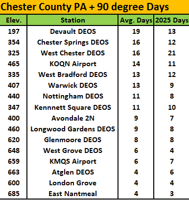
I suspect we are likely done with any more 90 plus days this year. Over at the PHL Airport they saw an above average of 36 such days.....here in Chester County a bit different story. We don't have our usual NWS COOP hot spots (Phoenixville and Spring City) reporting yet but below are current available stations with their 90+ days so far this year vs. each station's average number of such days.