All Activity
- Today
-
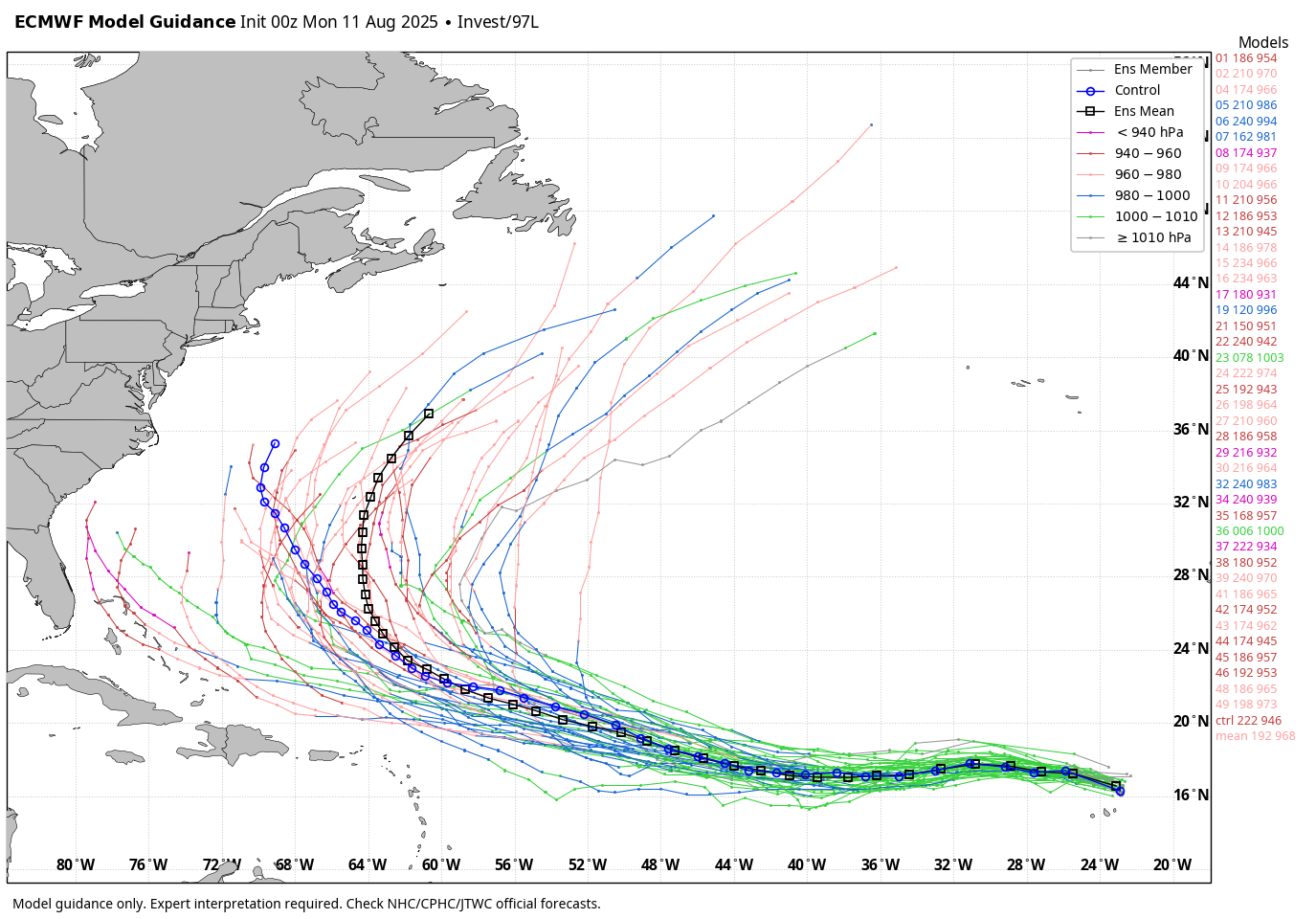
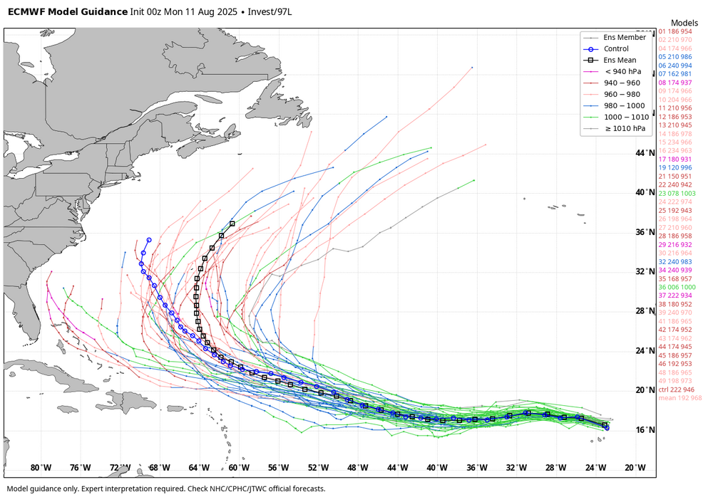
WB 0Z EPS tracks. Mean east of Bermuda, well east of the coast.
-
I cracked 90 with a high of 89.8 yesterday.
-

Invest 97L - NOW AT 60/90
LongBeachSurfFreak replied to BarryStantonGBP's topic in Tropical Headquarters
Regardless of eventual direct impacts on the east coast, a major hurricane that makes it west of 60 west will be a prolific swell producer. Since it is relatively early beaches will be impacted. Closures for rip currents, and minor beach erosion. -
Go fishe
-

Invest 97L - NOW AT 60/90
LakeNormanStormin replied to BarryStantonGBP's topic in Tropical Headquarters
Highly unlikely that thing makes it to the US based on those above graphics. There is a notable northward component this far out. And some projected kinks in the ridge down the road to add. But it will absolutely moisten the palate for everything that follows. -
Cmc also
-
Hope you get it along with lots beneficial rain while staying real safe.
-
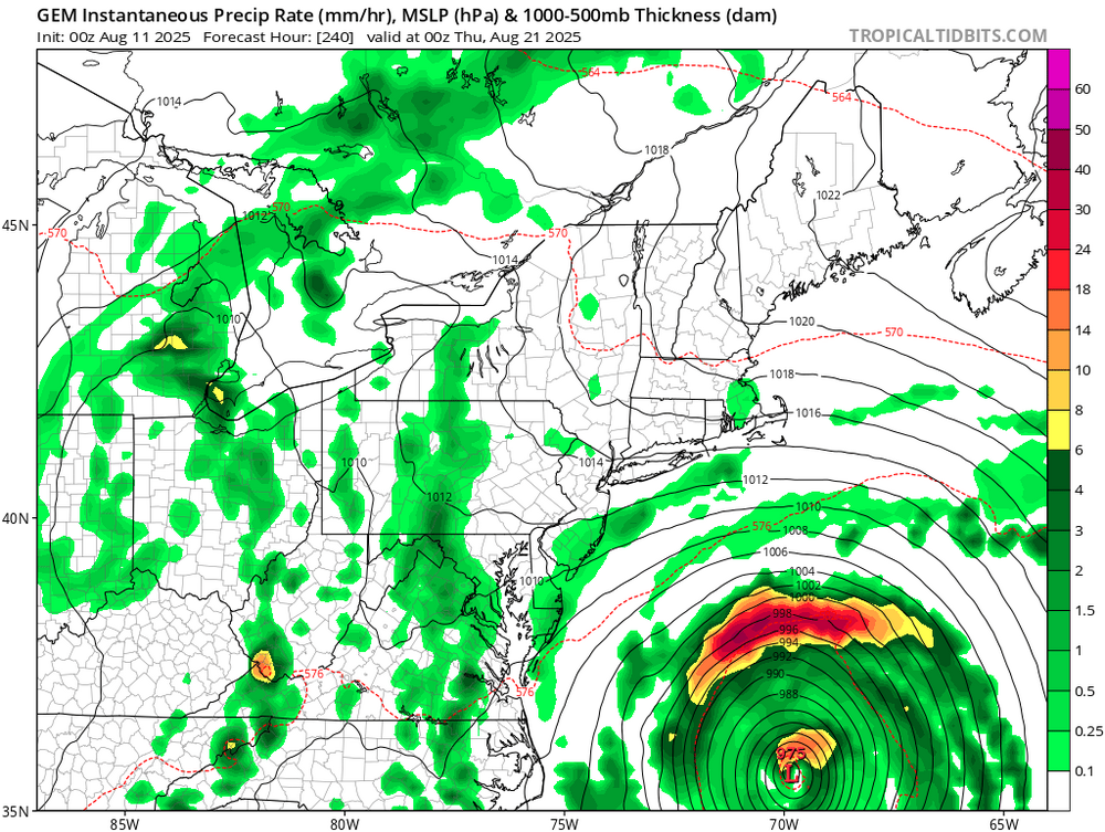
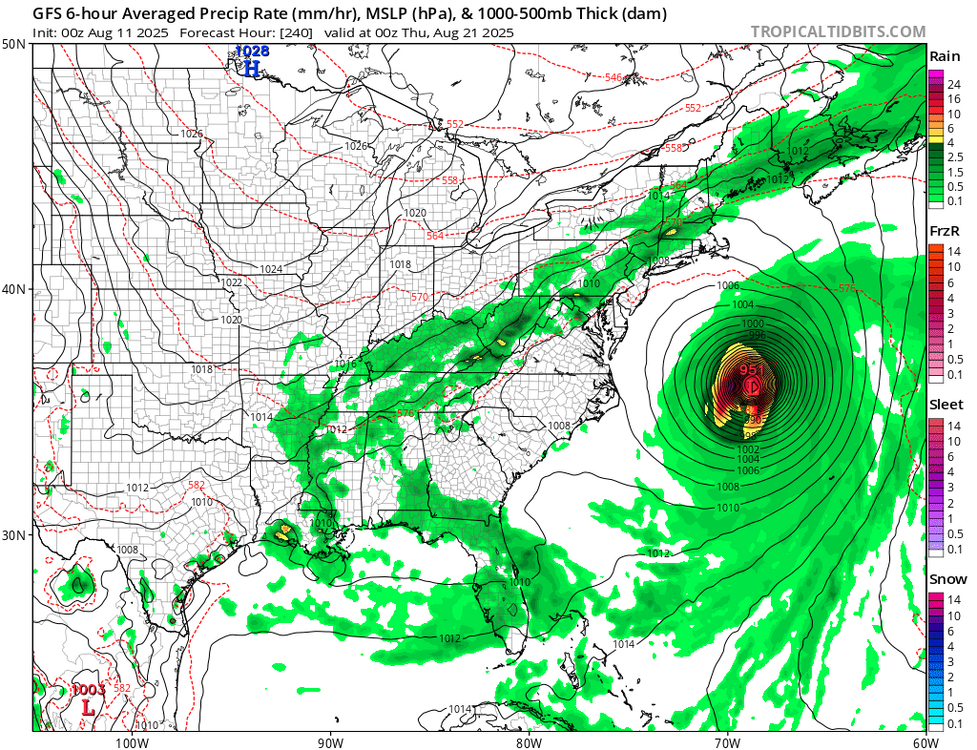
Closer on gfs
-
0Z UKMET for what may be first AEW behind 97L: NEW TROPICAL CYCLONE FORECAST TO DEVELOP AFTER 150 HOURS FORECAST POSITION AT T+150 : 16.0N 49.7W LEAD CENTRAL MAXIMUM WIND VERIFYING TIME TIME POSITION PRESSURE (MB) SPEED (KNOTS) -------------- ---- -------- ------------- ------------- 1200UTC 17.08.2025 156 17.0N 51.1W 1010 27 0000UTC 18.08.2025 168 18.4N 53.9W 1011 24
-
0Z UKMET recurves along 63.3W: NEW TROPICAL CYCLONE FORECAST TO DEVELOP AFTER 30 HOURS FORECAST POSITION AT T+ 30 : 17.8N 32.8W LEAD CENTRAL MAXIMUM WIND VERIFYING TIME TIME POSITION PRESSURE (MB) SPEED (KNOTS) -------------- ---- -------- ------------- ------------- 1200UTC 12.08.2025 36 18.1N 35.6W 1008 32 0000UTC 13.08.2025 48 17.5N 39.4W 1007 29 1200UTC 13.08.2025 60 17.9N 42.4W 1007 30 0000UTC 14.08.2025 72 18.8N 45.3W 1007 31 1200UTC 14.08.2025 84 19.9N 48.8W 1007 31 0000UTC 15.08.2025 96 20.5N 51.8W 1006 30 1200UTC 15.08.2025 108 21.0N 54.9W 1005 40 0000UTC 16.08.2025 120 21.7N 57.2W 1004 42 1200UTC 16.08.2025 132 22.8N 60.0W 1003 46 0000UTC 17.08.2025 144 23.9N 61.7W 1003 44 1200UTC 17.08.2025 156 25.7N 63.3W 1003 42 0000UTC 18.08.2025 168 28.1N 63.3W 1003 45
-
Better. Yes it looks like a generally dry period for our area, but there is some uncertainty. Any rain we do see will most likely come in the form of convection and it will be scattered. Haves and have nots.
-
PBL at 90F vs. 95F at BTV. The PBL readings should lead to some great studies. Record highs at 100F or chilly lake induced air? How did that site produce the random highs it did this summer?
-
It's gonnabe a cold, very snowy winter 2025-26 in the Mid Atlantic. Get those shovels ready. Stock up on whatever you use to stay awake. Because you will be tracking weather models into late March over snow after snow after snow after snow after snow after snow after snow after snow after snow. By late January 2026, many of you will be sick and tired of digging the snow from your driveways. You will be fed up with waking up after spending 14 hours clearing your walk and driveway entrances from the latest blockbuster blizzard that dumped 30 inches of snow, to a huge, Brobdingnagian snow berm that the damned plow guy left you, right across your driveway, about eight feet high and frozen in place by single digit low temperatures and northerly winds gusting to 55 mph, to say nothing of drifting. You'll break out the ice pick and various tools, trying to chip through that snow and ice berm, falling right on your azz, right in front of your neighbors who will be cracking up so damned hard that they will be sliding on the ice like lemmings. Someone will inevitably capture your hilarious, Fail Tube flailing pratfall right on your tailbone on their trusty high end phone and post it straight to YouTube, where it will rack up over ten million views in 24 hours, assuring the channel owner a steady flow of fresh cash while everyone in your local neighborhood will be pointing straight at you and laughing uproariously while brandishing their phones and tablets.
-
After having no rain throughout the daytime of 8/10, which allowed me to go to Tybee with some friends, rain showers (some heavy) coming off the ocean moving NW started at 11:30PM. It looks like per radar that periods of rain may last til after midnight.
-
One of the silver linings of crippling depression is staying home and not having to step out into the miserable heat. Now, if I can just figure out how to have crippling depression while working remotely I'll be golden.
-
 I can guarantee rain here on Wednesday night. I plan on taking my car to the car wash on Wednesday morning to wash off all the dead bugs from my road trip to Niagara and the Finger Lakes this past weekend. Weather was mid to upper 80's and beautiful up there.
 -
I mean...that's a TC to me. SHIPS has continued to get more aggressive with development, and now has this becoming our first major hurricane of the year in a few days when it reaches a more favorable environment. 97L is getting an upper level assist from a passing CCKW, but heat content and SSTs will significantly improve further west. That said, note the drier air ahead of it though. It may impact its ability to intensify despite its current IR display.
-
The next time Wiz complains about every swirl getting named by the NHC I'll just show him this. IR, surface obs, and sat wind estimates have had this a TC for a good portion of the day.
-
Gotta finalize but each winter lately has kinda slowly improved from disaster and I think that trend continues
-
 I'm surprised it's drier there than 1965, 1966, 1993, 1999, 2002 and 2010. It's good to see 2010 still #1 for heat though.
 -
2010 was such a magical historic summer
-
thats 1965, 1966 level (well close anyway).
-
that was an unexpected 90 at NYC, the dryness must be doing its magic there
-
it felt rather hot after 4 pm
-
How much snow before the inevitable changeover?