All Activity
- Past hour
-

September 2025 OBS-Discussion centered NYC subforum
donsutherland1 replied to wdrag's topic in New York City Metro
Despite the dry end to August, precipitation is running above normal through the first two weeks of September and much above the amount for last year. 2025 is September 1-13 precipitation, but none is expected today. While this does not ensure that the month will finish above normal, it is a welcome development.
-
feels like summer today
-
Let us weep Sent from my SM-G970U1 using Tapatalk

-
Yeah the GFS may be overdoing (overdewing?) that, but with the dry ground there won’t be much modification. It’ll still be relegated to the typical cold spots mtns-north, but maybe a little more widespread than just the typical ASOS 32s? Maybe we get HUL in on it.
-
Nothing above a 30-40% chance of rain the next 10 days. This keeps up along with our talent in wind is going to create ripe conditions for a nasty forest fire Sent from my SM-G970U1 using Tapatalk
-

September 2025 OBS-Discussion centered NYC subforum
anthonymm replied to wdrag's topic in New York City Metro
Cold early September is a classic fake out. We don't truly shake summer off totally these days until like mid October. -
My hunch on low off NC is no but it is going to be interesting to watch it's track and see what it delivers to the Mid-Atlantic area in terms of rainfall and wind gusts. As for the MDR region feature I'd say if it happens it will be after 9/17. Things still look less than ideal for development in the MDR. Slower development is the better hedge IMO.
- Today
-

September 2025 OBS-Discussion centered NYC subforum
Sundog replied to wdrag's topic in New York City Metro
It's not out of the ordinary. -

September 2025 OBS-Discussion centered NYC subforum
nycwinter replied to wdrag's topic in New York City Metro
real summery feel outside this morning i cant believe in mid sept we are still having days like this.. -
They should leave you alone. It’s getting frozen out in another month or two anyway.
-
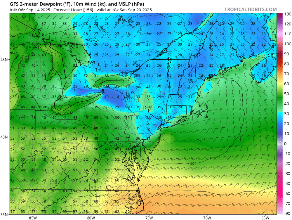
Dew the dew next weekend. Likely some frost chances where it can decouple given those afternoon Tds.
-
I pray it will at least be interesting and throw down a few surprises. Lots of different early casting around the world right now.
- 1 reply
-
- 1
-

-
Though boring for tracking, I think it’s absolutely fascinating what’s been going on this Sept so far. The last time Sept had no TC this far into the month was way back in 1992! It had its first Sep TC on Sep 17th. If 2025 doesn’t get a TD+ by Sep 17th (going to be close because of many models progging the current E MDR AEW to become a TD near or just after that day; also have to make sure the low off NC doesn’t do the same), then 2025 would have the latest 1st Sep TC since 1939’s Sep 23rd! Any predictions on whether either the current MDR AEW or the low off of NC will reach TD status by Sept 17th?
-
Upstate SC Spartanburg...Gaffney...Union areas getting very dry as well and people with sinus and headache issues are really feeling the pressure increase
-
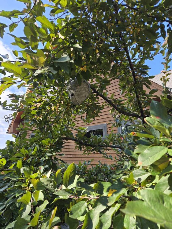
I have to cut the lawn at some point near this thing. Not a fan of hornets. Don't they have people that can remove these without killing them? Sent from my SM-S921U using Tapatalk
-

September 2025 OBS-Discussion centered NYC subforum
Picard replied to wdrag's topic in New York City Metro
It got quite threatening looking up here in the afternoon and evening yesterday. Nothing, not even a drip. Everything was well east. -
@CAPE https://www.espn.com/nfl/story/_/id/46245106/ravens-planned-take-shedeur-sanders-draft-sources-say Would have been interesting to see
-
September 2025 OBS-Discussion centered NYC subforum
anthonymm replied to wdrag's topic in New York City Metro
With no cool downs in sight September might average seasonable if not slightly above normal no? Much warmer looking nights ahead as well. -

September 2025 OBS-Discussion centered NYC subforum
wdrag replied to wdrag's topic in New York City Metro
Late yesterday (9/13/25) shower amounts via CoCoRaHs Click if in disbelief.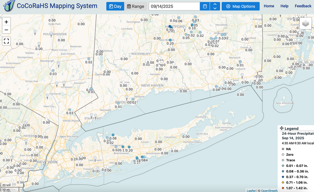
-
Ooph. Just found this big hornets nest in our ornamental tree Sent from my SM-S921U using Tapatalk
-
Thanks, Snowman. 1. Agreed. I think it’s absolutely fascinating what’s been going on this peak season so far. The last time Sept had no TC this far into the month was way back in 1992! It had its first Sep TC on Sep 17th. If 2025 doesn’t get a TD+ by Sep 17th (going to be close because of many models progging the current E MDR AEW to become a TD near or just after that day; also have to make sure the low off of NC doesn’t become a TD), then 2025 would have the latest 1st Sep TC since 1939’s Sep 23rd! 2. But to clarify, predictions from reputable forecasters were for slightly to moderately above avg activity rather than hyperactive. Also, mine (which can be seen in the AmerWx Contest thread) was for only slightly above avg ACE of 139 as well as 14 NS, 9 H, and 3 MH: 2. Don, Chris, and myself found with our research over the last month and posted ITT that any correlation between ACE and NYC snowfall the following winter has been weak at best. So, it not being hyper doesn’t say much as regards NYC snowfall prognosis. The slight correlation at best means the chance this season of 35”+ there in 25-26 is decreased only a little by a not AN ACE season.
-
September 2025 OBS-Discussion centered NYC subforum
Sundog replied to wdrag's topic in New York City Metro
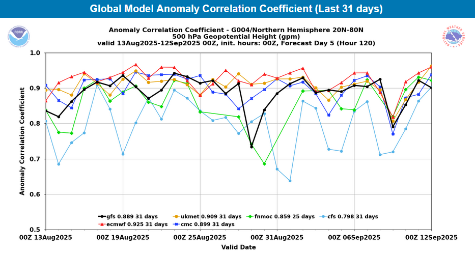
Excellent post Don. I've been saying for years that a model's usefulness goes far behind it's 500mb hemispheric score. -
September 2025 OBS-Discussion centered NYC subforum
donsutherland1 replied to wdrag's topic in New York City Metro
For reference, the ECMWF and EPS have been running a fairly strong warm bias in the short range. Meanwhile, the ECMWF continues to rank first in 500 mb anomaly scores: This divergent outcome is a reminder that there is more to forecasting than 500 mb maps. All the details matter. In terms of specific numbers, below were the 9/12 0z EPS forecast highs for Central Park: September 13: 80 (actual: 77) September 14: 86 September 15: 83 September 16: 82 September 17: 83 September 18: 84 September 19: 81 Below were the 9/12 0z ECMWF forecast highs for Central Park: September 13: 80 (actual: 77) September 14: 86 September 15: 84 September 16: 82 September 17: 86 September 18: 90 September 19: 87 Today could reach the lower 80s, tomorrow may reach 80°, Thursday has a shot at 80°, and Friday could be the warmest day, reaching the lower and maybe middle 80s. Interior sections of NJ will be warmer and Friday could see upper 80s there.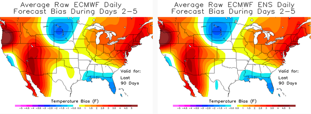
-
Let's dew it..