All Activity
- Past hour
-
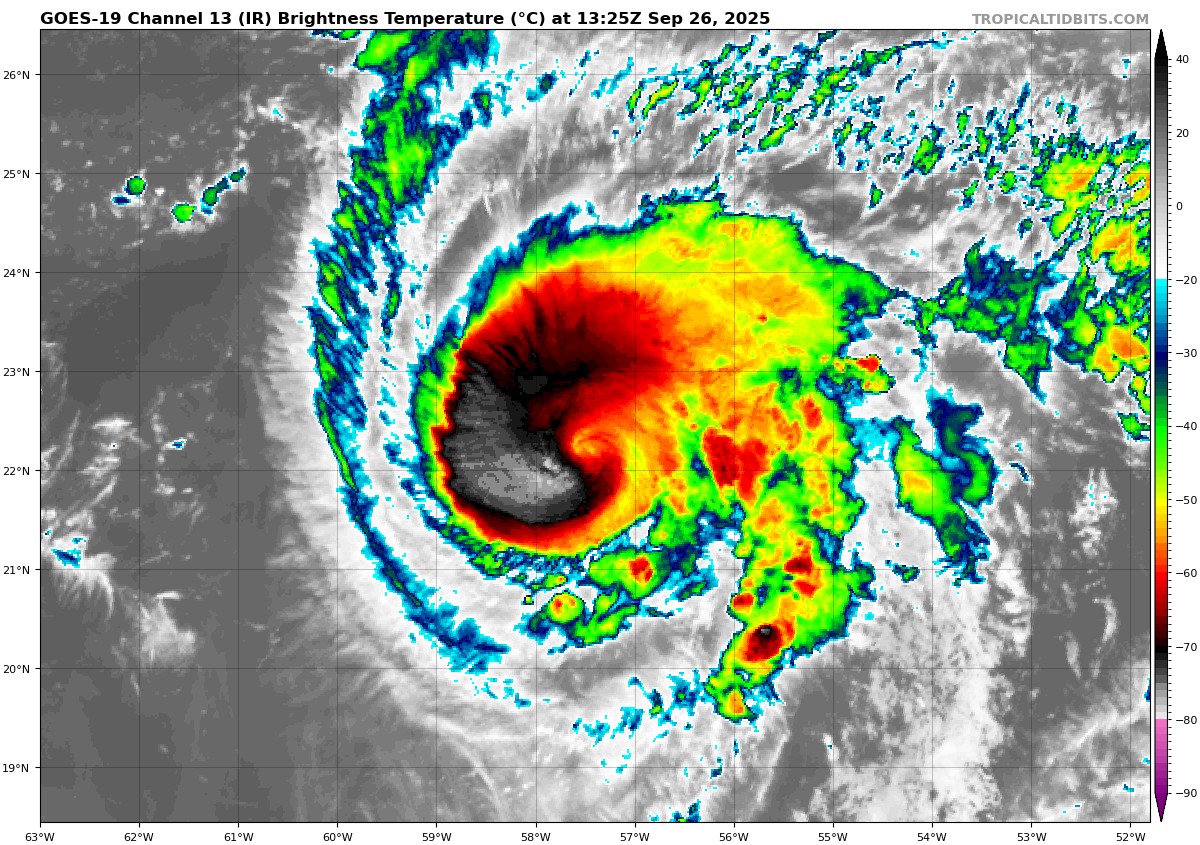
Humberto is much stronger than a Cat 1 right now, special advisory should be in order before 5pm
-
Humberto looks to be trending stronger than expected so far, and track is trending more towards Bermuda...if the trends continue, how will this impact the track of the other storm? Interesting to watch it play out...
-
20-21 I’d rate as good to very good here, 21-22 as generally average but good for the eastern 2/3 of LI that was slammed by the Jan blizzard. Islip I think had close to BOS’s snow for the season and 24” in the blizzard. The best of 2020-21 was NYC and west.
-

2025-2026 ENSO
40/70 Benchmark replied to 40/70 Benchmark's topic in Weather Forecasting and Discussion
We probably won't indentify it until we see the whites of the snow. -
Humberto going nuclear. This might be a cat 5 candidate
-
No, it wasn't that. It was yellow (or like a golden brown) with the light orange body or brownish orange. But it was crawling at me...I had no choice.
-
As a Cowboys fan, I approve of this message.
-
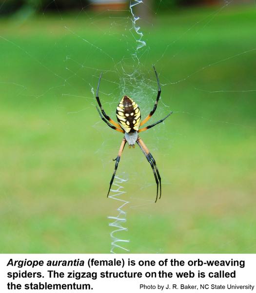
Storm total 2.64", almost as much as July/August combined (2.85"). About 1.8" fell 5 PM-midnight. Neither the Sandy nor the Carrabassett have risen much, about 1/2 foot. The upper parts of their watersheds received less rain - 'Bassett 1.14" and Rangeley probably about the same. Sounds like orb weavers. They’re great at killing other bugs. Non venomous to humans I've read that almost all spider species are poisonous - it's how they eat - but very few are dangerously poisonous.
-
Stop killing spiders weenie. Hope it wasn’t one of these argiopes. These are great spiders.
-
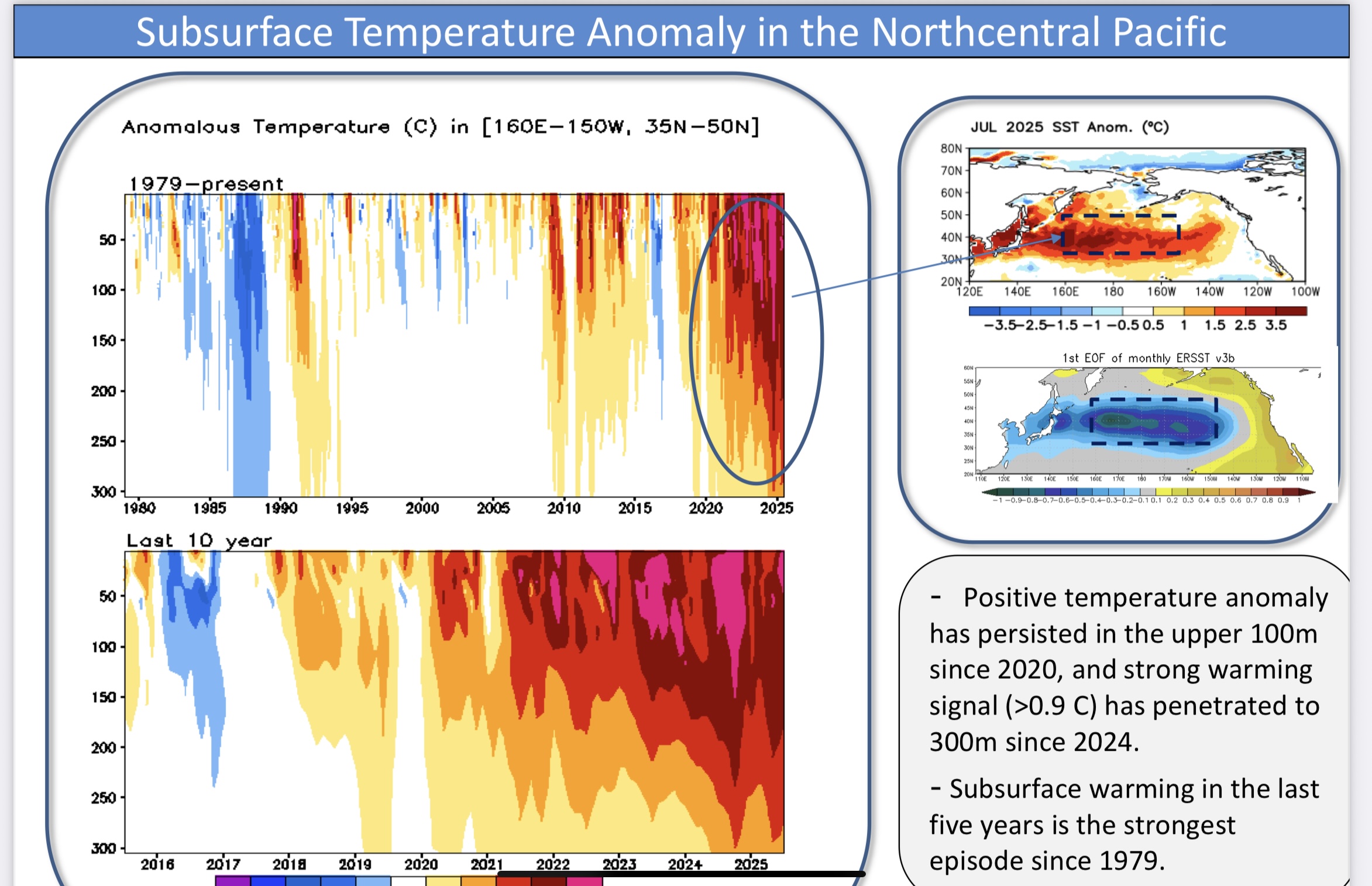
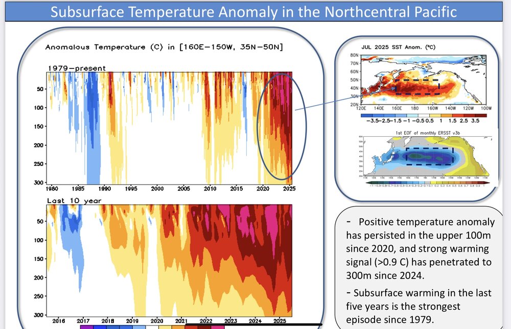
Yeah, those surface SSTs are very impressive. They recently helped to drive the 4 sigma jet streak near the Aleutians when combined with the record cold in Siberia. Just a tremendous thermal gradient. So we are currently getting the big EPO and PNA volatile swings as the shortwaves are racing through the very fast Pacific flow. But they are only the tip of the iceberg since there is so much stored heat below the surface. This deep reservoir of warmth contributed to the record Pacific Jet last winter even though there was the deepest trough in 25 years east of Japan. Past instances of strong troughs east of Japan had much colder SSTs and a much weaker Pacific Jet. But the surface SSTs hardly cooled which maintained the strong SST gradient and faster Pacific flow with the record cold in Siberia. So it gave us the warm storm track through the Great Lakes. Going forward I am trying to find other areas which can offset this dominant climate feature since 2018-2019. But it’s still a work in progress. The last time we were able to push back against this feature was in January 2022. It took the MJO 8 tropical forcing to disrupt the pattern for a month. I will be happy if we can find another competing source of forcing in the coming years to help the snowfall bounce even a little above the 2019 to 2025 record seven year lows. But it may be a challenging task with that massive WPAC heat engine. This cutter, hugger, and suppressed Southern Stream storm track has become very persistent since the 2018-2019 winter when the rapid SST warming took of in the WPAC.
-
The only light I keep on is just outside the back door but its not particularly bright and inside a cove (not sure what its technically called but its an overhang which connects the house with the garage.
-
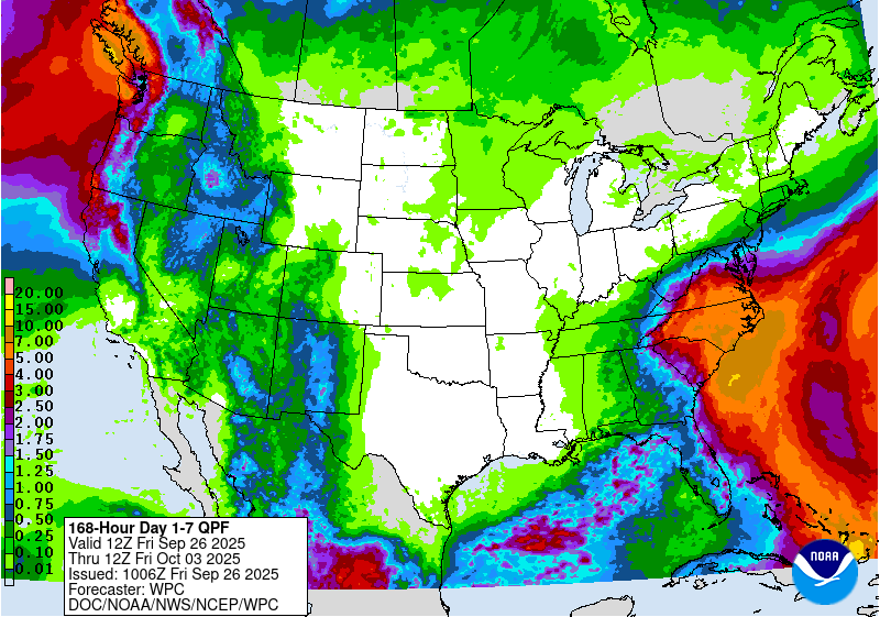
There is not much rain at all the next 16 days on the GFS. We desperately need some tropical loven Sent from my SM-G970U1 using Tapatalk
-
Hurricane Humberto Discussion Number 8 NWS National Hurricane Center Miami FL AL082025 1100 AM AST Fri Sep 26 2025 Humberto continues to rapidly strengthen this morning. Infrared satellite images show a ring of deep, cold inner core convection wrapping around an eye that has recently emerged in conventional satellite imagery. Objective satellite intensity estimates are quickly climbing, and the initial intensity is raised to 80 kt for this advisory, in best agreement with recent UW-CIMSS ADT and AiDT estimates. A recent ASCAT-B pass over the hurricane was used to update the 34- and 50-kt wind radii of Humberto. The rapidly improving satellite structure, along with conducive environmental and oceanic conditions, suggest that significant to rapid intensification (RI) is likely to continue in the short term. In fact, the latest DTOPS guidance shows a greater than 80 percent chance of Humberto strengthening by 30 kt in the next 24 h. Thus, rapid intensification is explicitly forecast here, and the NHC intensity forecast has been raised during the first 48-72 h of the forecast period. This forecast most closely follows the regional hurricane models and the HFIP corrected consensus (HCCA), on the higher end of the guidance envelope. By early next week, there are indications that deep-layer shear will increase over Humberto, and some weakening is shown beyond 72 h. Note that as Humberto gains latitude, the wind field is forecast to expand while the hurricane curves around Bermuda at days 4-5. The hurricane is moving slowly northwestward at about 4 kt. Humberto should move toward the west-northwest and northwest during the next couple of days along the southern periphery of a subtropical ridge over the western and central Atlantic. As this ridge slides eastward, the hurricane is forecast to recurve around this feature, turning northward and then accelerating northeastward early next week. The models are in very good agreement on this sharp recurvature over the western Atlantic, and only minor adjustments were made to the latest NHC track forecast. FORECAST POSITIONS AND MAX WINDS INIT 26/1500Z 22.3N 57.7W 80 KT 90 MPH 12H 27/0000Z 22.5N 58.3W 95 KT 110 MPH 24H 27/1200Z 22.9N 59.6W 105 KT 120 MPH 36H 28/0000Z 23.3N 61.3W 115 KT 130 MPH 48H 28/1200Z 24.1N 63.3W 125 KT 145 MPH 60H 29/0000Z 25.3N 65.2W 125 KT 145 MPH 72H 29/1200Z 26.8N 66.9W 120 KT 140 MPH 96H 30/1200Z 30.6N 68.8W 105 KT 120 MPH 120H 01/1200Z 34.5N 66.0W 90 KT 105 MPH $$ Forecaster Reinhart
-
Do you keep outside lights on at night? Good way to attract lots of spiders (and f up migrating birds, but that's a different story)
-
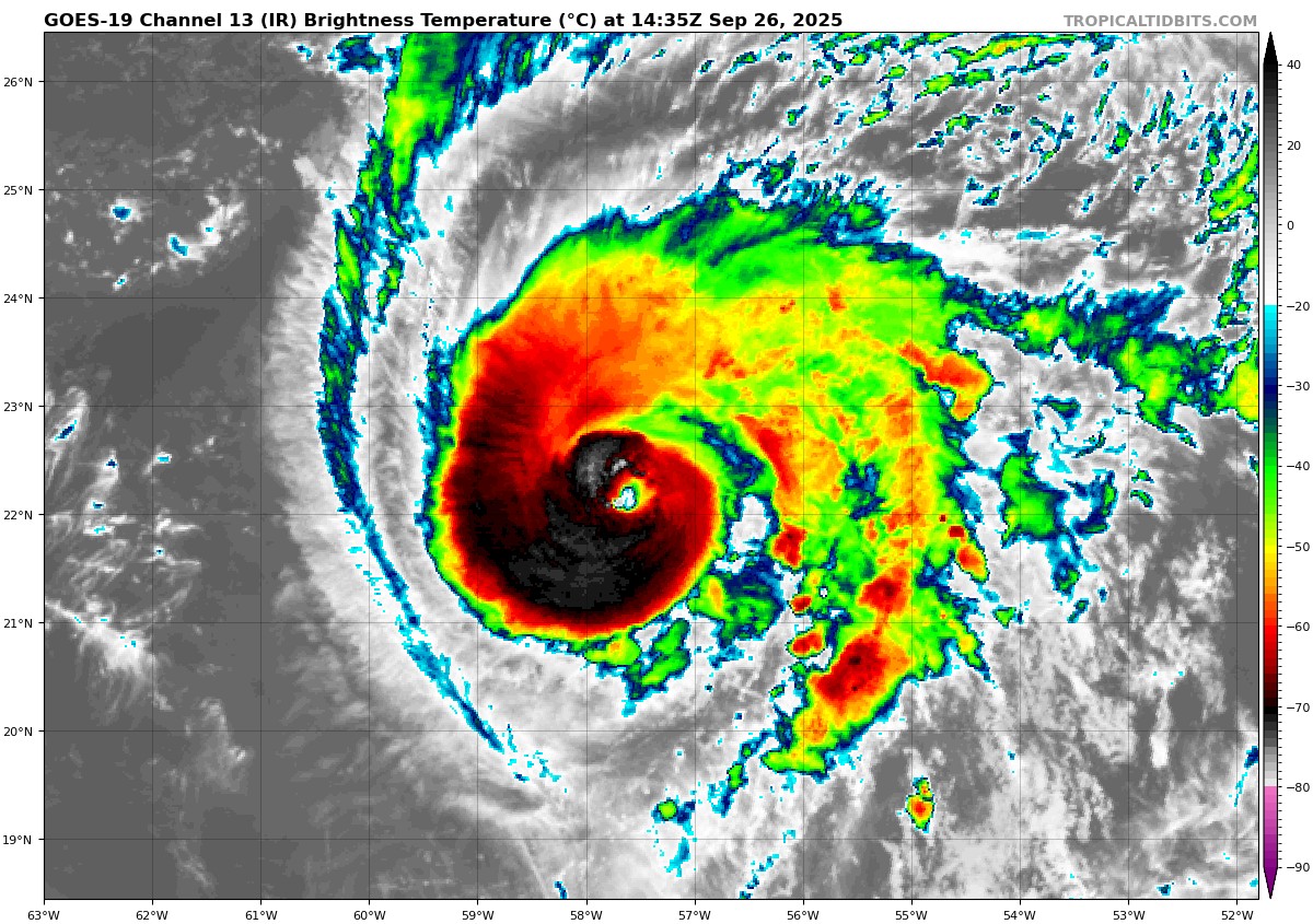
Just over an hour apart


-
Looks like some true Autumnal weather arrives later next week - highs in the 50s to mid 60s with lows in the 30s to mid 40s.
-

September 2025 OBS-Discussion centered NYC subforum
jm1220 replied to wdrag's topic in New York City Metro
Some good swells coming in a few days anyway. Won’t be like Erin because a smaller storm but Humberto should produce some decent ones since it’s forecast to get to Cat 4. -

September 2025 OBS-Discussion centered NYC subforum
SACRUS replied to wdrag's topic in New York City Metro
Already 78 / 67 here -
Hey, it's just mother nature tipping her hand as to how winter's going to play out...lol
-
Looks like RI is well underway.
-
@weathafella

-
hmmm could be those. what kind is the "common yellow house spider"?
- Today
-

2025-2026 Fall/Winter Mountain Thread
Maggie Valley Steve replied to Buckethead's topic in Southeastern States
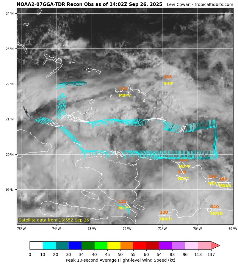
The first low level recon is underway. So far there is no indication of surface circulation.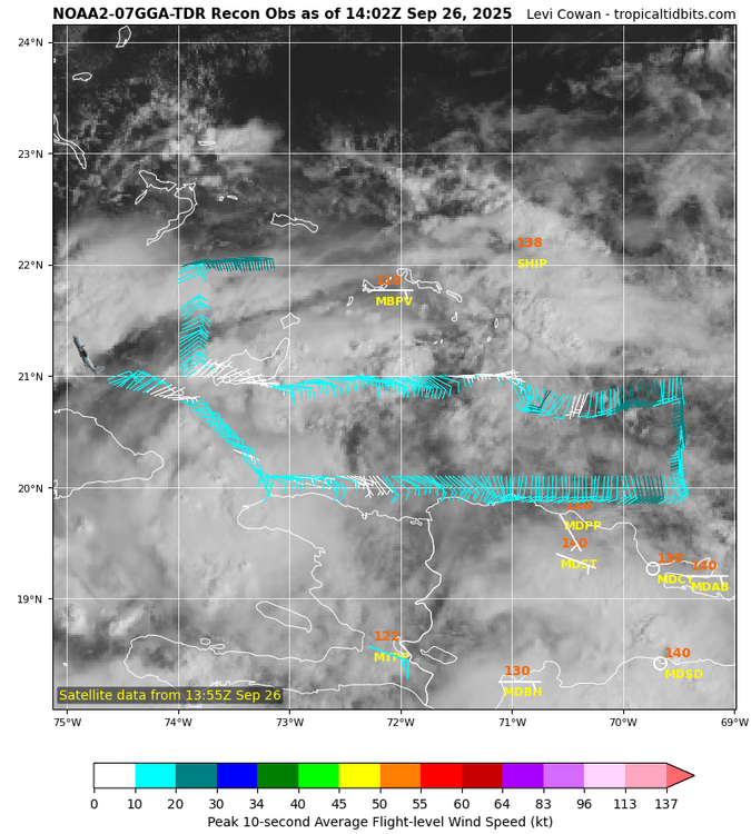
-
2025-2026 ENSO
40/70 Benchmark replied to 40/70 Benchmark's topic in Weather Forecasting and Discussion
Also, remember...SSTs are part of a feedback, which is the reason for the correlation, but they don't run the show....if the atmosphere begins changing, the sea will not lead the way.