All Activity
- Past hour
-
Yes, it did make landfall here, I wonder why no one ever talks about that, was it a minimal tropical storm when it was making landfall here?
-
Already up to 5.5" of rain for the month. Quite a few power outages around after the line came through last night. Surprised CLE only reported .35" of rain yesterday... must have been missed by almost every storm.
-
Agnes
-
I could see this becoming an anvil/mammata late afternoon from southern VT/W CT, with distant ominous thunder that devolves to just occasional orange lightning and a period of moderate decay rains. Nasty mosquito evoking weather where it's warm and sultry with lighter rain might be the biggest disaster the befalls western zones out of this when that claims the late day for them. You should probably plan to chase to see that
-
Total since the 16th is a whopping .6 Not like it's needed because everything is plenty soggy but I feel like I got cheated.
-
Only caveat on Sunday is clouds (debris) from the MCS to the north and any storms that make it south, but agree Sunday hits 90 as it should clear out and be hot enough in gerneral (overall) especially in the hot spots and the more south you go.
-
1972 - Hurricane Agnes moved onshore near Cape San Blas FL with wind gusts to 80 mph, and exited Maine on the 26th. There were 117 deaths, mainly due to flooding from North Carolina to New York State, and total damage was estimated at more than three billion dollars. Up to 19 inches of rain deluged western Schuylkill County PA. The rains of Hurricane Agnes resulted in one of the greatest natural disasters in U.S. history. Agnes caused more damage than all other tropical cyclones in the previous six years combined (which included Celia and Camille). (David Ludlum) (The Weather Channel) Didn't Agnes also make a landfall near JFK Tony? 1794: A violent tornado commenced west of the Hudson River in New York. The tornado traveled through Poughkeepsie then crossed the border into Connecticut where it went through the towns of New Milford, Waterbury, North Haven, and Branford. It then continued into Long Island Sound. The tornado did extensive damage, and the funnel was reported by one observer to look like the "aurora borealis." <<< this must have been an F3 at least 1835 - A tornado tore through the center of New Brunswick NJ killing five persons and scattering debris as far as Manhattan Island. The tornado provided the first opportunity for scientists to study firsthand the track of such a storm. (David Ludlum) <<< this sounds like an F3 too also wow, you don't see stuff like this in this region anymore. and this must have been the peak of the heat in 1994, July and August were not this hot for us (but very hot for Philly.) Not historical like 1993, but just a step below it. Highs: EWR: 103 (1994) NYC: 98 (1994) LGA: 97 (1994) JFK: 98 (1994)
-
Next area of clouds already in WPA with an arrival of between 1 - 2 PM we'll see if its more scattered clouds or if storms develop later this PM. Off to the races the next 4 - 6 hours.
-
An intensifying 998 low in the St Lawrence valley and most of us get jack dick. Why do people bother with convection?
-
Not saying this is a positive or negative for today, however, sometimes I think there is too much focus on the timing of the actual cold front for our region. 9 times out of 10, the focus for our convection is a pre-frontal trough and never with the actual cold front. In the rare setups where we get moderate-to-extreme instability, that is where we can get a second round of convection with the cold front but when it comes to forcing/dynamics its usually s/w track and timing and pre-frontal trough. Now...more often than not the better dynamics are typically tied in close proximity to the cold front. Pre-frontal troughs can be a huge boost for us but they also kill alot of our opportunities.
-

2025-2026 ENSO
40/70 Benchmark replied to 40/70 Benchmark's topic in Weather Forecasting and Discussion
I would have to agree. -

Central PA Summer 2025
Mount Joy Snowman replied to Voyager's topic in Upstate New York/Pennsylvania
Low of 69 with .03” of rain. We’ll be on the river this morning. Probably have to pull out early this afternoon. Keeping a close eye on things. -
people who love blue skies and sunshine. find an a/c to stand near
-
Im already sweating Who the hell likes this crap?
-
I have 16 yards of natural mulch Staring at me.. Stay safe out there today.
-
Another morning where I ALMOST set a new 'warm minimum'. Low was 65.8, record 67 from 2000. At least I see some blue skies and the sun trying to break through. It has been either cloudy or foggy for many a morning in a row here. Currently 67.3/66.0 at 8 am.
-
2025-2026 ENSO
40/70 Benchmark replied to 40/70 Benchmark's topic in Weather Forecasting and Discussion
-EPO is my early hedge for next winter, as well...I was just telling a forecaster on FB that I associate with that I feel good about ridging INVO AK next season. -
First morning in months with a clear sky. It feels like today is going to feature some rough weather.
-
On the contrary... it's typical to dawn murky high dps with a patchwork of fog and low strata on severe days. This is in fact expected behavior. There are sunny/skylights stationary E of the topography; this is keyed into high DP air mingling with shallow nocturnal inversion resulting basically in very low level 'steam'. It's not even 8 am and no sooner the sun tips over treetops and there's rapid evap ongoing. Not just typical, it's physically obvious why this is the case, too. Our biggest limitation on the day most likely will be timing. This may evolve more across central NY/PA along that axis, with a few descrete/dangerous cells then organizing into linear segments. The better instability will be there extending down into the M/A. There's not a lot of CIN in these areas. Oriographic assisted cu features will probably take off without restraint and quickly. This does not include areas E of Albany initially. The whole synopsis doesn't bring the front through here until 2+am overnight so that E NE may not be in the party at all. May get some activity into western zones as the typical accelerating outflows organize/pool and propagates down wind and triggers/cyclic development. There may also be a prefrontal trough ... there's so little inhibition in this whole set up, that could trigger and rob down in the eastern PA/PHL/NJ area. SPC's got it pretty well covered.
-
The fog is going to erode rather quickly, except maybe valleys
-
78 dew 71 start to the day
-
mlvl lapse rates are much worse than modeled. Wonder if the air got totally overturned from the convection yesterday across the Great Lakes/Ohio Valley. Have to see what some of the 12z soundings look like.
-
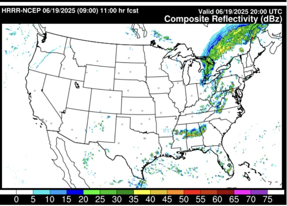
Hrrr brings pf convection into wcpa around 2:00pm . Although it fires off storms on both fronts and Inbetween It likes the pft as the dominant line of convection. By 4:00pm the leading convection has just crossed the Susquahanna river.
-
Records: Highs: EWR: 103 (1994) NYC: 98 (1994) LGA: 97 (1994) JFK: 98 (1994) Lows: EWR: 53 (1954) NYC: 49 (1914) LGA: 56 (2022) JFK: 54 (1965) Historical: 1794: A violent tornado commenced west of the Hudson River in New York. The tornado traveled through Poughkeepsie then crossed the border into Connecticut where it went through the towns of New Milford, Waterbury, North Haven, and Branford. It then continued into Long Island Sound. The tornado did extensive damage, and the funnel was reported by one observer to look like the "aurora borealis." 1835 - A tornado tore through the center of New Brunswick NJ killing five persons and scattering debris as far as Manhattan Island. The tornado provided the first opportunity for scientists to study firsthand the track of such a storm. (David Ludlum) 1934: A hurricane in the Gulf of Mexico came ashore in Louisiana, then moved northeast, passing over northern Delaware, Philadelphia, PA and central New Jersey as an extratropical storm, with sustained winds of 45 mph. Philadelphia received 1.70 inches of rainfall on the 18th into this date, and New York City had 1.93 inches on this date, a daily record. As the storm passed over Philadelphia, the pressure dropped to 29.40 inches of mercury. (Ref. Wilson Wx. History) 1938 - A cloudburst near Custer Creek, MT, (near Miles City) caused a train wreck killing forty-eight persons. An estimated four to seven inches of rain deluged the head of the creek that evening, and water flowing through the creek weakened the bridge. As a result, a locomotive and seven passenger cars plunged into the swollen creek. One car, a tourist sleeper, was completely submerged. (David Ludlum) 1944: Hailstorm caused great destruction to fruit crop in Winchester, Virginia. 1964: A squall line producing large hail swept through central Illinois, followed by two more consecutive lines passing shortly after dawn. The resulting hailstorms caused damage in excess of $9 million dollars, as hailstones the size of grapefruits brought havoc to trees, utility lines, crops and buildings. The thunderstorms also produced as much as 5 inches of rain over an 8-hour period. (Ref. Wilson Wx. History) 1965: The Arkansas River crested at 15.68 feet at Dodge City, KS. Heavy rains in Eastern Colorado combined with three broken dams started the torrent of water which flowed through Colorado and Kansas. The river rose seven feet in 15 minutes between 9 AM and 9:15 AM. The deepest part of south Dodge was about 7 feet under water. The deep water created other problems, when gas regulators were covered, pressure built up in the gas lines and Dodge City was rocked by explosions. Total urban losses in Dodge City and Wilroads Gardens were estimated at nearly $3.8 million dollars, including damages to 615 residences and 155 businesses. 24 Kansas counties were declared flood disasters. (Ref. Wilson Wx. History) 1972 - Hurricane Agnes moved onshore near Cape San Blas FL with wind gusts to 80 mph, and exited Maine on the 26th. There were 117 deaths, mainly due to flooding from North Carolina to New York State, and total damage was estimated at more than three billion dollars. Up to 19 inches of rain deluged western Schuylkill County PA. The rains of Hurricane Agnes resulted in one of the greatest natural disasters in U.S. history. Agnes caused more damage than all other tropical cyclones in the previous six years combined (which included Celia and Camille). (David Ludlum) (The Weather Channel) 1987 - It was a warm June day, with plenty of thunderstorms east of the Rockies. Lightning knocked out power at Throckmorton, TX, and ignited an oil tank battery. A woman in Knox City TX was struck by lightning while in her car, and a man was struck by lightning near his home in Manatee County FL. Strong thunderstorm winds overturned several outhouses near Bixby OK, but no injuries were reported. (The National Weather Summary) (Storm Data) 1988 - Temperatures soared above 100 degrees in the central U.S. for Father's Day. Fifteen cities reported record high temperatures for the date. Severe thunderstorms in Minnesota and Wisconsin produced softball size hail near River Falls WI, and wind gusts to 80 mph at Menomonie WI. (The National Weather Summary) (Storm Data) 1989 - Fourteen cities reported record high temperatures for the date as searing heat spread from the southwestern deserts into the High Plains Region. Record highs included 98 degrees at Billings, MT, 107 degrees at Valentine, NE, and 112 degrees at Tucson, AZ. (The National Weather Summary) 1990 - What would eventually be known as the "Inland Hurricane" stuck south central Kansas. This storm system produced a swath of 65 to 120 mph winds across six counties and caused $80 million dollars in damage. The peak recorded wind gust was 116 mph, which reaches low-end category 3 on the Saffir-Simpson hurricane wind intensity scale. On the enhanced Fujita Scale the 116mph winds would be rated an EF2. The storm knocked out power to all the Wichita TV stations, and they were off the air for hours. All but one of the Wichita Radio Stations, including the Wichita NOAA Weather Radio Station KEC-59, was knocked off the air. (National Weather Service Wichita) 2006 - Up to 11 inches of rain fell in the Houston, Texas area, causing widespread flash flooding. The Houston Fire Department rescued more than 500 people from flood waters, but no serious injuries or fatalities were reported
-
Always “fun” to be on the bad side of a record performance


.thumb.jpg.6a4895b2a43f87359e4e7d04a6fa0d14.jpg)


