All Activity
- Past hour
-

2025 ENSO/Winter Speculation
Prismshine Productions replied to 40/70 Benchmark's topic in New England
Slightly above (+3.6", 60.1 total) Sent from my SM-S166V using Tapatalk -
Called the airport-- apparently the equipment is still there and this relates to a data feed issue at all USAF maintained sites. No estimate on resumption of data but it likely will be resumed.
-

September 2025 General Discussion
TheClimateChanger replied to Geoboy645's topic in Lakes/Ohio Valley
-
Looks wetter, starting Friday into much of next week. Also appears Lorena in the Eastern pacific will give us an opportunity for tropical remnants middle of next week. I’m thinking for my back yard - just need to make it through next three days with watering and the worst is far behind.
-
 The average high temperature for Newark NJ this time of year is around 78 to 79 F. We are going to be above normal.
 -
13 of the 19 current Chester County stations recorded their driest August on record. Of note those stations have less years with data. That said on average it appears this to be the 3rd driest August since 1893 across our fair county. The driest such months occurred in 1896 and 1943.
-

E PA/NJ/DE Autumn 2025 Obs/Discussion
ChescoWx replied to PhiEaglesfan712's topic in Philadelphia Region
13 of the 19 current Chester County stations recorded their driest August on record. Of note those stations have less years with data. That said on average it appears this to be the 3rd driest August since 1893 across our fair county. The driest such months occurred in 1896 and 1943. -
Seems like KCEF may have been decommissioned... No official word but it's getting the unperson treatment on all official sites... Bummer From UMass and the surrounding area it's 40-60 mins by car to ORE, ORH, BAF, & BDL
-
12Z UKMET, after having it for the first run in a couple of days as a TD on the 0Z run (though it later weakened), is back to having the low too weak to be classified as a TC.
-

September 2025 OBS-Discussion centered NYC subforum
donsutherland1 replied to wdrag's topic in New York City Metro
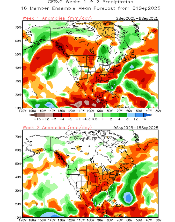
Consistent with the idea that a dry end of August often leads to below normal rainfall during the first week of September and September overall, the latest NBM has further trimmed rainfall amounts from yesterday's runs. Now, it shows some showers on Friday and then Saturday evening into Sunday morning with a frontal passage. Rainfall amounts for both events are light. The latest CFSv2 shows drier than normal conditions through at least its Week 1 and Week 2 forecasts. All said, early on, September appears to be on course for a drier than normal month. Model skill falls off sharply beyond two weeks.
-

September 2025 OBS-Discussion centered NYC subforum
winterwx21 replied to wdrag's topic in New York City Metro
Finally a little heat and humidity Friday into Saturday, but what a stretch of weather after that. Behind the front it's going to be a long period of cool comfortable weather. It's going to be great weather next week, but boy do we need rain. The chance of rain Friday into Saturday doesn't look impressive. -
Barry, I’d rather not address those ITT, but that area may be active by midmonth. 12Z ICON is much weaker than and S of the 0Z run and has WSW motion to 15N, 49W at 168 well below a 600 dm H5 high at a steady state 1003 mb/TS.
- Today
-
have you even seen the WCAR/BOC ensembles last night innit?
-
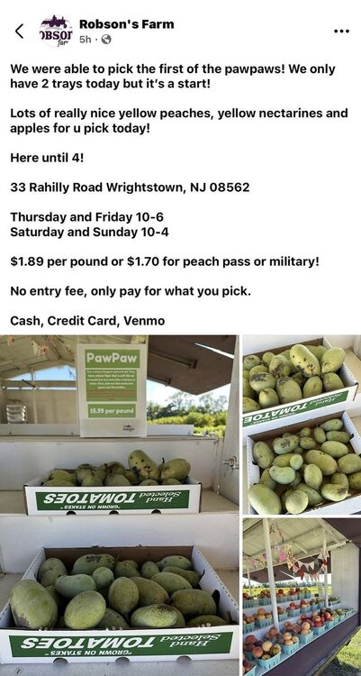
Not sure if you’re familiar with this place, but they have ripe pawpaws starting and some days with PYO tours.
-

September 2025 OBS-Discussion centered NYC subforum
SnoSki14 replied to wdrag's topic in New York City Metro
Cool mornings plus dry conditions -
Yeah I’ll take anything at this point…even a wedged all day -RADZ fest.
-
Concord got an inch last week. I was down there Saturday and you could tell…the lawns greened back up and there were puddles. But in town here looks like Arizona. I’m afraid to water my potted trees with how slow the well is to refill. Hopefully Fri/Sat delivers something substantial.
-

September 2025 OBS-Discussion centered NYC subforum
Stormlover74 replied to wdrag's topic in New York City Metro
Noticing some leaf color change already -
Anything’s possible. It could blow up in especially the W half of the Caribbean if it gets to the E Car pretty weak. By the way, note that per Deepmind that the faster members are more of a threat to the Caribbean/further S.
-
can we just get one strong low with widespread rain
-
We were racking it up in the first half with all of those wet weekends. 1 rain event in 5 weeks is rough though.
-
Road the Northern Trail yesterday from Franklin up to Danbury and back - lots of leaves on the ground with many others looking they will soon be on the ground.
-
About as exciting as that
-
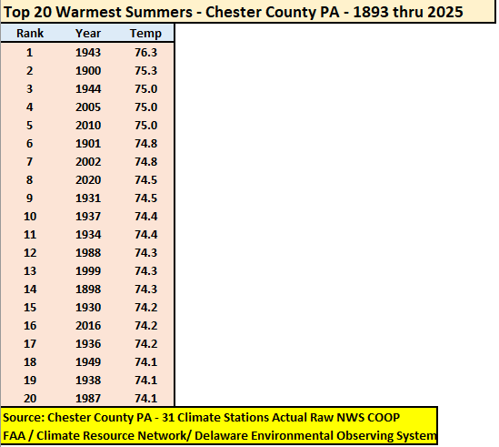
At an overall average temperature of 73.0 degrees the summer of 2025 finished as the 54th warmest summer across 133 years of records in the Philly burbs of Chester County PA. The top 20 warmest summers are listed below.
-
E PA/NJ/DE Summer 2025 Obs/Discussion
ChescoWx replied to Hurricane Agnes's topic in Philadelphia Region
At an overall average temperature of 73.0 degrees the summer of 2025 finished as the 54th warmest summer across 133 years of records in the Philly burbs of Chester County PA. The top 20 warmest summers are listed below.