All Activity
- Past hour
-
Kinda saw that coming. More in line with the rest of guidance for now. We got time. Watch the Euro make a big shift NW over the next few runs lol.
-

First Legit Storm Potential of the Season Upon Us
UnitedWx replied to 40/70 Benchmark's topic in New England
True, but it doesn't mean the GFS is better. Look at 6Z lol. Waffle waffle -

First Legit Storm Potential of the Season Upon Us
moneypitmike replied to 40/70 Benchmark's topic in New England
Tell me about it. At least for the next couple of years, I'll typically be in Maine during the week/Mattapoisett on the weekends. I'll need to hope the storms cooperate! -

January 2026 Medium/Long Range Discussion
Stormchaserchuck1 replied to snowfan's topic in Mid Atlantic
6z GFS a miss 2" for Richmond - Va beach -

First Legit Storm Potential of the Season Upon Us
The 4 Seasons replied to 40/70 Benchmark's topic in New England
you in Mattepoisett now, damn thats a rough spot for snow lovers -

First Legit Storm Potential of the Season Upon Us
TauntonBlizzard2013 replied to 40/70 Benchmark's topic in New England
Still feel mostly the same. This largely misses -

Central PA Winter 25/26 Discussion and Obs
Voyager replied to MAG5035's topic in Upstate New York/Pennsylvania
Ugh...where did this Saturday snow come from? I'm likely picking up a new vehicle on Saturday, (trading in the Jeep for a GMC Terrain) and am not exactly wanting it's maiden voyage to be on snowy or icy roads. -
First Legit Storm Potential of the Season Upon Us
moneypitmike replied to 40/70 Benchmark's topic in New England
AIGFS is just outside the BM. Mattepoisett rejoices. -
First Legit Storm Potential of the Season Upon Us
The 4 Seasons replied to 40/70 Benchmark's topic in New England
really would like to see Euro trend west at 12Z and the ensembles. I dont expect GFS to show hit after hit at this range, waffling happens, having the European suite on board is more important.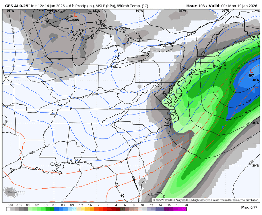
-

First Legit Storm Potential of the Season Upon Us
ineedsnow replied to 40/70 Benchmark's topic in New England
Ya just saw that -
Low popped off the coast of FL on 0z… now its back to popping out in the atlantic .
-
First Legit Storm Potential of the Season Upon Us
The 4 Seasons replied to 40/70 Benchmark's topic in New England
Op went east, AI went west go figure -

First Legit Storm Potential of the Season Upon Us
Damage In Tolland replied to 40/70 Benchmark's topic in New England
Friday night into Saturday on wave 1 with 1-3/2-4 interior That one sped up. -
6z GFS not nearly as good as 0z. Just did not have the moisture this run.
-
First Legit Storm Potential of the Season Upon Us
ineedsnow replied to 40/70 Benchmark's topic in New England
Euro FTW?.thumb.png.5beae14ecdaa89af68176bc86de3221e.png)
-
First Legit Storm Potential of the Season Upon Us
ineedsnow replied to 40/70 Benchmark's topic in New England
It was chasing that convection to.the east and tried developing that low.. might be wrong but who knows.. -
First Legit Storm Potential of the Season Upon Us
ineedsnow replied to 40/70 Benchmark's topic in New England
6z GFS = meh -
January 2026 Medium/Long Range Discussion
Stormchaserchuck1 replied to snowfan's topic in Mid Atlantic
6z NAM has a kicker diving into the Great Lakes It's close though.. might do it We need more wave spacing or 1st wave to be primary energy. -
First Legit Storm Potential of the Season Upon Us
ineedsnow replied to 40/70 Benchmark's topic in New England
Ya 6z GFS doesnt look as good at hr72 -
Lol I was thinking the same thing.
-

January 2026 regional war/obs/disco thread
Snowcrazed71 replied to Baroclinic Zone's topic in New England
Not after today..... Back to Winter from Friday on..... -
Why are we awake right now? Three days before and the models are still all over the place. lol.
-

E PA/NJ/DE Winter 2025-26 Obs/Discussion
Ralph Wiggum replied to LVblizzard's topic in Philadelphia Region
EPS also well offshore for Sunday.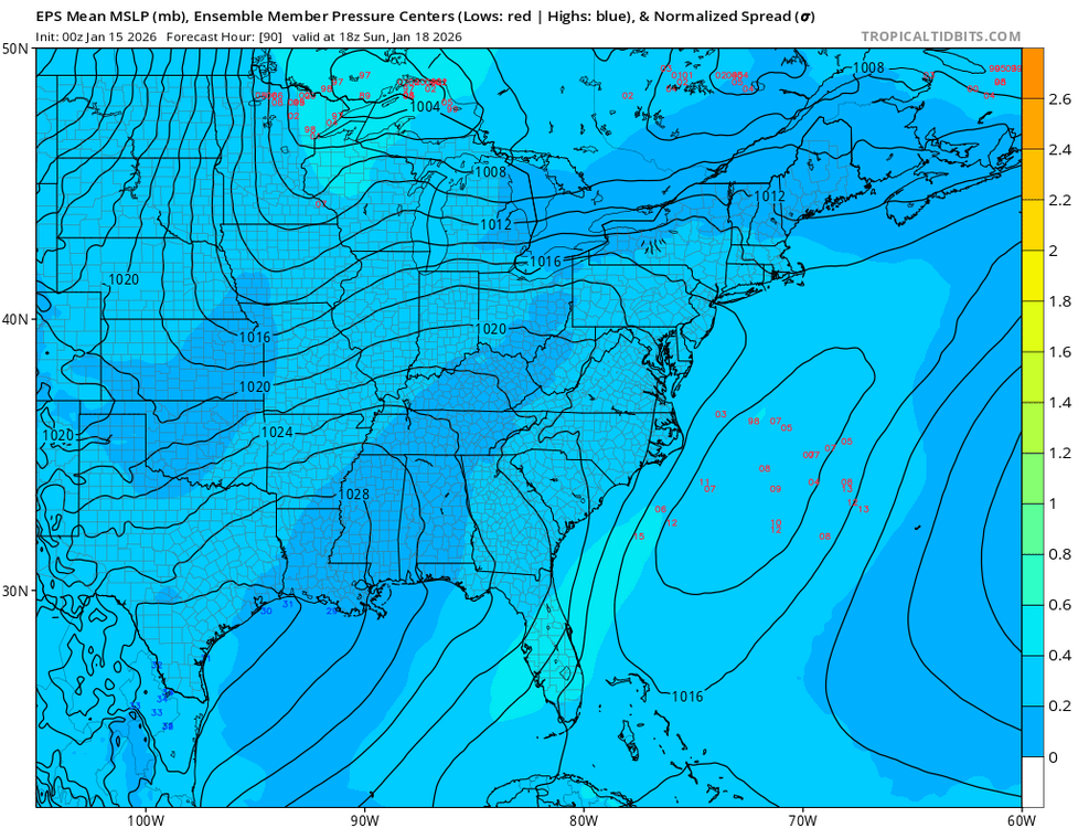
-
E PA/NJ/DE Winter 2025-26 Obs/Discussion
Ralph Wiggum replied to LVblizzard's topic in Philadelphia Region
Euro didnt budge and is a good bit offshore. ICON ticked SE just a smidge with the Sunday system. Getting deja vu here with the GFS likely pulling a Lucy. -

First Legit Storm Potential of the Season Upon Us
WxWatcher007 replied to 40/70 Benchmark's topic in New England
I’m still extremely skeptical of this one. There’s still a reasonable scenario where this scrapes rather than hits most of interior NE.


.png.df75bbb2ed586b949d4bd829e953ecb8.png)

