All Activity
- Past hour
-
Perhaps you are unclear on the concept of "not based upon all present indicators ... "
-
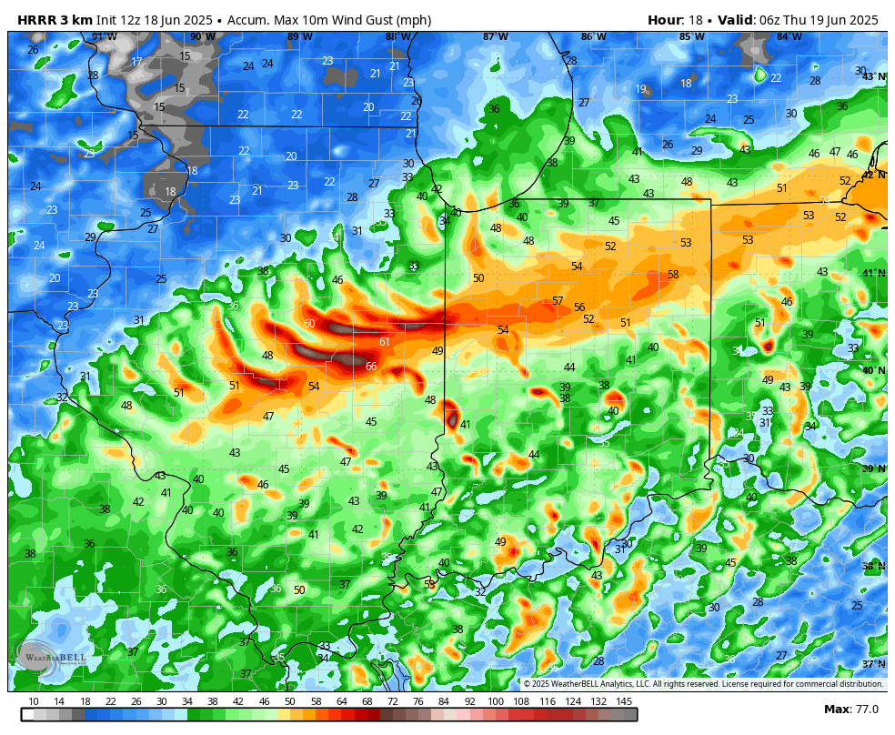
I think the HRRR is underplaying aerial coverage tomorrow
-
The last couple runs of the HRRR have been particularly ridiculous with that: I just want some good rain before the heat arrives this weekend.

-
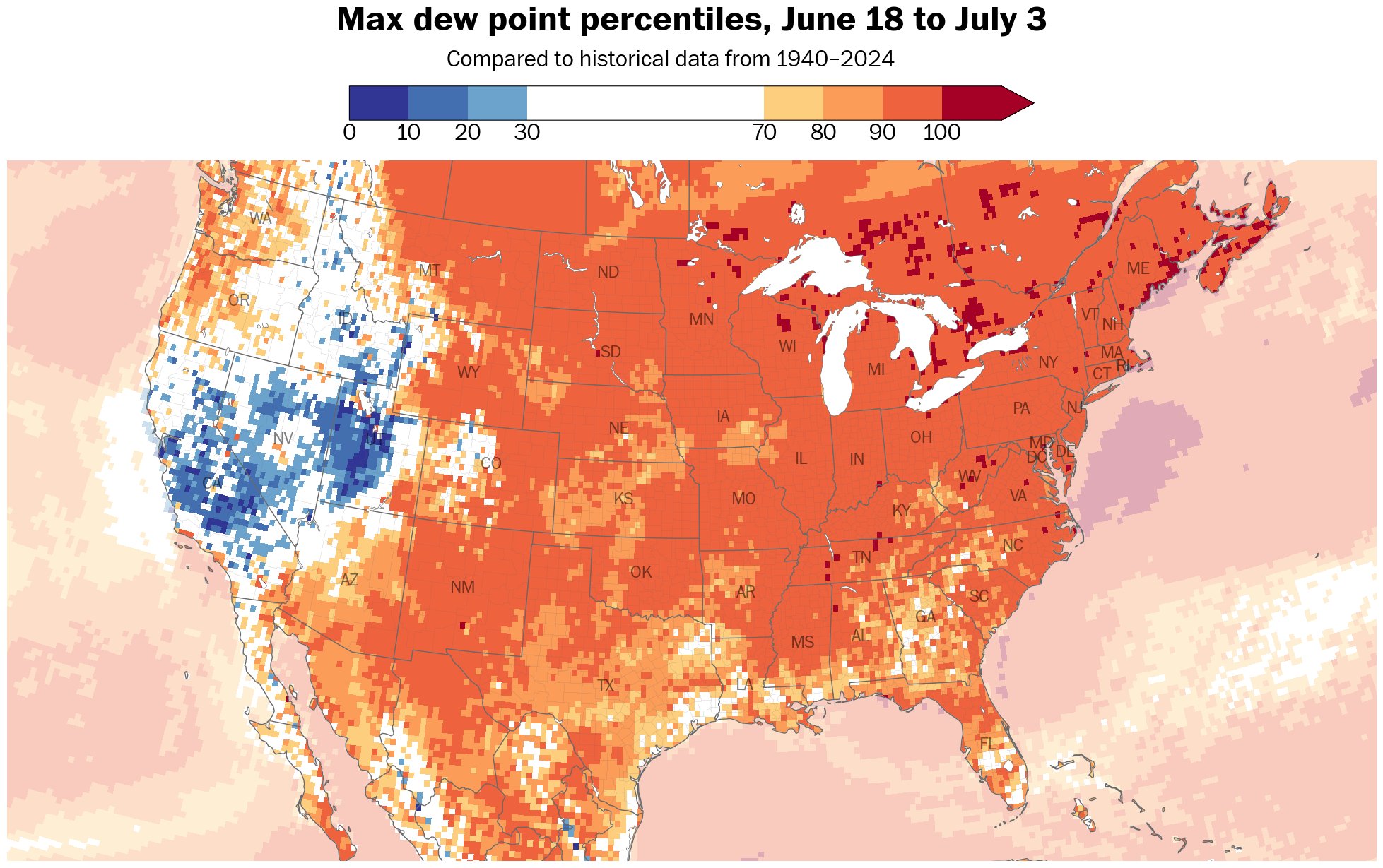
Not only hotter, but more moist and humid as dew points reach the 90 th percentile, or greater, over a vast area of the US.
-
We shall be seeing an enhanced risk tomorrow for at least western MA and western CT
-

2025 Atlantic Hurricane Season
BarryStantonGBP replied to BarryStantonGBP's topic in Tropical Headquarters
to that one guy on storm2k who predicted 13/6/3: every day is a fine day right? -
Central & Eastern Pacific Thread
BarryStantonGBP replied to Windspeed's topic in Tropical Headquarters
I heard someone had a dream last week (when Dalila was active) of logging onto the NHC front page and seeing a Category 4 off the west coast of Mexico, well before models started to initialize Look what we have here now -
Could be some record breaking high minimums.
-
Every piece of guidance has 3-4 days of 90+
-
Lol pencil that in for late September
-
Socked in again this morning with clouds, fog, mist and drizzle. Another .15" rainfall last 24 hours. Has gotten very humid and on the muggy side.
-
WHY do we keep doing this?
-
Yeah, 12z HRRR looks a little better but still messy. Hopefully we avoid too much crapvection before the main line moves through. Optimistically… I can hope whatever pops ahead of the line is rotating and interacting with the leftover boundaries from the storms that just came through here.
-
hrrr selling a 2" drought buster, need to lock in
-
Starting to look like more run of the mill type heat for most especially the city and east. The eastern periphery of the ridge is prone to backdoor fronts and cloud/T-storms. Also looks like winds will try hard to veer onshore which heightens the humidity but would make it hard to reach 95. But if we have dewpoints well into the 70s with temps over 90 it’s still disgusting. Just not historic, more like our more typical FL type heat of late. Inland away from the seabreezes or backdoor intrusions can likely make it to 100.
-
Kind of a contnuation of that buregeoning theme from last cold season of a colder se Canada...lets keep that going into next winter.
-
This is not a correct assessment based upon all present indicators ... it's okay bro. It's only mid June. We'll have other shots at this over the next 6 to 8 weeks ( before the GFS routines begins snowing at D10 in mid August LOL )
-
Mid range attenuation not of just winter threats, but of anything remotely interesting, though this one I'll take.
-
NWS HeatRisk is slowly escalating from Sunday through Tuesday, though we still aren’t seeing Extreme values punching into New England just yet. https://www.wpc.ncep.noaa.gov/heatrisk/
-
Watch for some strong winds behind the line of storms today, particularly around the mesolow.
-
Jan 7 2024 was incredible...Feb 1 2021 was okay, too....but that's about it for me.
-
Totally socked in here with fog. Haven’t seen the sun in 5 days. Truly wretched stretch.
-
I had 3 rounds of thunderstorms too. Each one of them woke me up - totaled almost an inch of rain from them.
-
Yeah exactly. When we are bullseye several days out, the boundary nearly always ends up SW of us
-
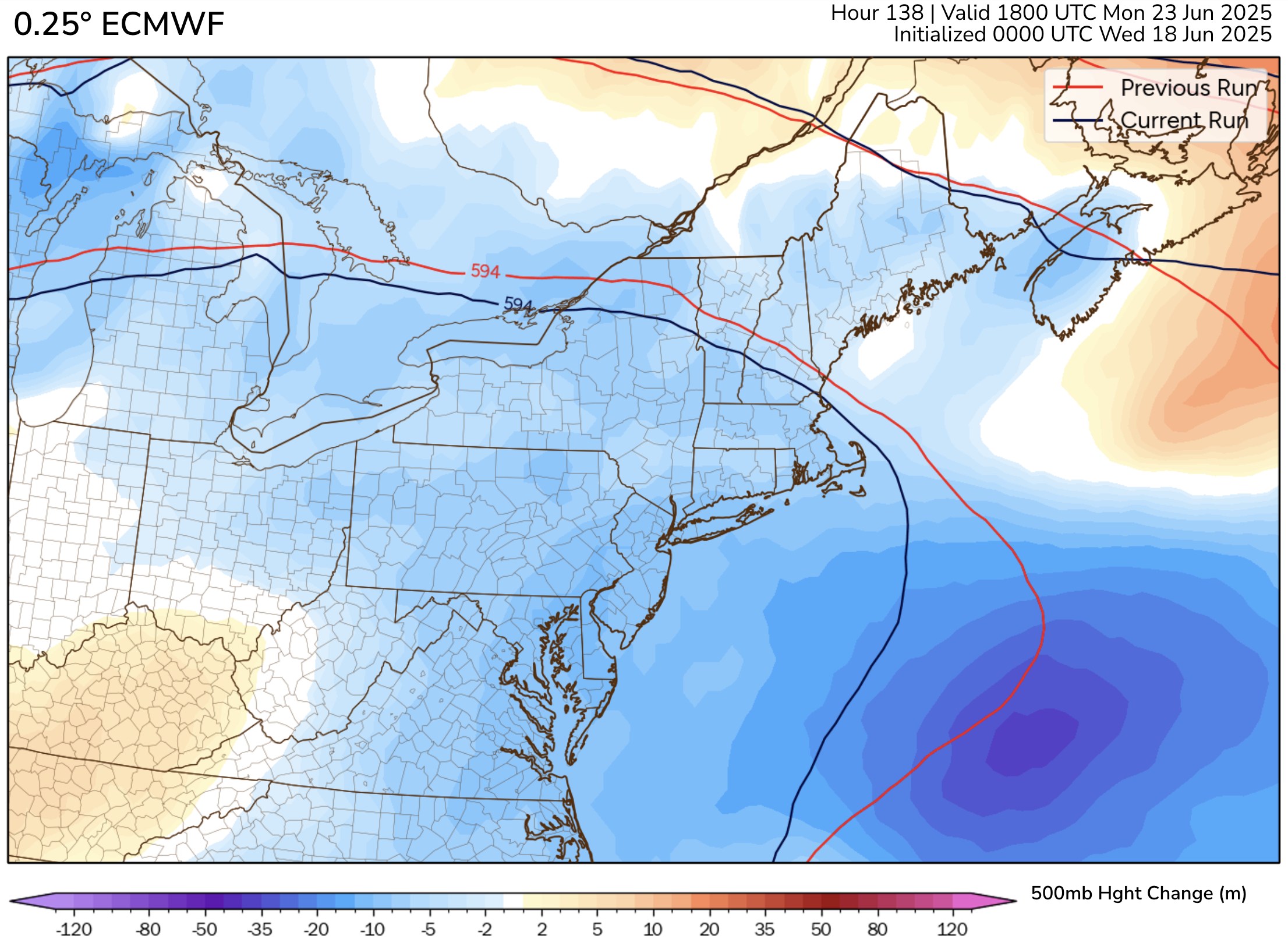
The regular Euro has seen somewhat larger drops in heights. This is for Monday: