All Activity
- Past hour
-
Look what I just posted in my edit haha we had two events like that during the early 90s and one was a complete surprise (the first one)
-
I remember some type of event from the early 90s where the Weather Channel was showing models forecasting moderate snow dropping down from the north in a line. Even as a little kid I remember seeing that and thinking that was weird.
-
 lol. No, I've never been that ambitious to trudge over there for a measurement. I just consider my Riverside Park measurements to be a good enough proxy. And honestly, the temp at my location might be one of the better proxies for CPK you'll find. Per this map from a few years ago we are lucky enough to live in one of the "coolest" spots in Manhattan - this little tongue that extends to the river in the low 100s.
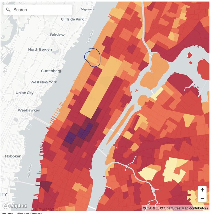
-
Sorry for the delayed response, just a little too much unfolding. House goes under contract. Inspection failed, contract withdrawn. Close to foreclosure, vehicle just as close to repo... SAD but true. I'm literally going to be on the street soon. I have lost everything with no solution.
-
the heaviest stuff is occurring right now lol
-
Suns coming out. Off to the torches!
-
Aw man I love that place. Great spot to just relax.
-
No I mean if we had precip coming down from the same direction (north) in the winter, even if it happened differently. I remember a couple of times we had surprise snowstorms in the winter when an arctic front came down from the north and stalled just south of us. February 1993 is one example, we got 4-7 inches of snow out of that (my favorite kind, all day snow that cleared right at sunset.) The other one was in February 1991 (if I remember this one correctly, my favorite snowstorm prior to January 1996), we had over 8 inches of snow during an arctic frontal passage that was never supposed to do anything except for a few rain showers changing to snow showers. The front stalled and a low formed just SE of the Hamptons and it snowed here for 36 straight hours (my longest snow event to this day-- thats why I loved this event so much and it was a complete surprise). It would have accumulated a lot more than 8 inches, but the snowfall during the day was while temperatures were 33-34, it really started accumulating at night and we were the bullseye. There was no snow west of Newark or east of the Hamptons. Boston and Philly got nothing.
-
We don’t get snow from a MCS
-

-
the rain is now getting heavy LOL
-
SPC removed us entirely from any threat today. I can’t argue with that, given that no guidance brings storms anywhere close to our area. That said, guidance has no real handle at all on that MCS.
-
this would be a nice surprise snowstorm in the winter lol
-
so some beach locations in Florida do hit 100 degrees on occasion!! 2009: Florida: Temperature records tumble with Vero Beach leading the record heat parade with a record high of 102°F and a heat index of 111°F. Elsewhere in the state, Tallahassee hits 103°F; Daytona and West Palm Beach, 96°F and Miami 98.°F.(Ref. WxDoctor)
-
You didnt read any of the posts for context. He wasnt praising a model for being correct nor touting technological advances. He was mocking all of the models. Hence the take a breath, you came in here attacking someone for something that you misread. Now go take that breath. Or play outside. Dont care. But take the nonsense somewhere else.
-
Awful performance by the models even at 6z.
-
Winds now in Farmingdale as I ride the LIRR east as pretty strong from the WSW. Not sure if that’s some mesoscale induced feature
-
Looking at some lows this morning. New monthly record high at Saint Cloud, Minnesota (80F). Minneapolis-St. Paul, Rochester, and Brainerd all fell one shy of the monthly record, but each set daily records. Wisconsin put up some insane numbers. These are all ThreadEx sites with long PORs. All subject to being maintained through midnight local standard time, which should be the case barring something unexpected. Hayward had a low of 80F, obliterating the prior monthly record of 75F by an insane 5F. The old record was last set on June 23, 2005. Also sets a new all-time record high minimum temperature. La Crosse had a low of 80F, tying the monthly record set on June 29, 1931. Green Bay had a low of 79F, breaking the monthly record of 78F last set on June 30, 1931. It also ties the all-time record high minimum temperature. Wausaw had a low of 78F, breaking the monthly record of 77F set on June 28, 1931. This was 1F below the all-time record of 79, set in 1999. Rhinelander had a low of 76F, breaking the monthly record of 75F set on June 27, 1991, and tying the all-time record high minimum temperature.
-
The economic impact for many will start to take a toll if this weekend rain pattern continues. An unexpected shower or T storm isn't that surprising in summer, but an extended organized batch of rain with no warning does suck, and seems rare in the warmer months. Also people had the plan to do some outdoor stuff early while the heat is at least tolerable. Now getting t storms moving through. Watch those NYC temps. Central Park underachieves temp wise even more when its wet there, compared to out in the open where it dries out faster.
-
I think makes it a wet weekend for everyone, look at how widespread the rain is.
-
How cute, 6z RGEM had upper 80s for 10AM. It's 73 degrees right now.
-
what causes it to move from north to south though? our winds are not coming from the north....
-
Where in the world are you located lol
-
yes on the positive side, barring any unforeseen rain (heh) next weekend should be in the low 80s with sunshine. Thursday will be the last hot day, major change coming by Friday. This is now normal for us, even if they are extreme, our heatwaves are rarely longer than 4-5 days anymore.
-
If you slept late, you missed it all! Should be a nice day from this point forward


