All Activity
- Past hour
-
Which Ensembles ? Just looked at the 12Z GEFS and we have only a couple days of cold outbreaks then when the storm approaches it cuts because of the southeast ridge and no blocking through the 1st week of DEC
-

November 2025 general discussions and probable topic derailings ...
CoastalWx replied to Typhoon Tip's topic in New England
EPS is cold To end. That’s a massive vortex in Canada. Would be nice to get some NAO ridging. -
At least snowpack should build in the Midwest the next few weeks..
.thumb.png.4d3e5f492a498f160599a1f9e0b2abca.png)
-

November 2025 general discussions and probable topic derailings ...
radarman replied to Typhoon Tip's topic in New England
That back edge in view from Treehouse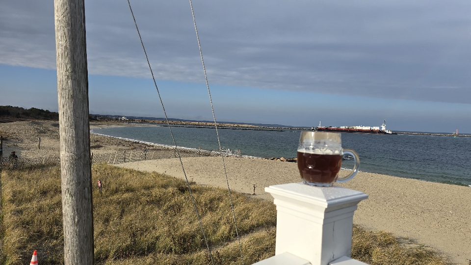
-
Negative to neutral NAO and PNA to just cooperate.
-
Need Neg NAO and that all important strong HP in southeast Canada anchored and a weakening of the southeast ridge - storms will cut west of us before this happens........seems like this is repeated here every year over and over - we all know the routine...........
-

2025-2026 ENSO
donsutherland1 replied to 40/70 Benchmark's topic in Weather Forecasting and Discussion
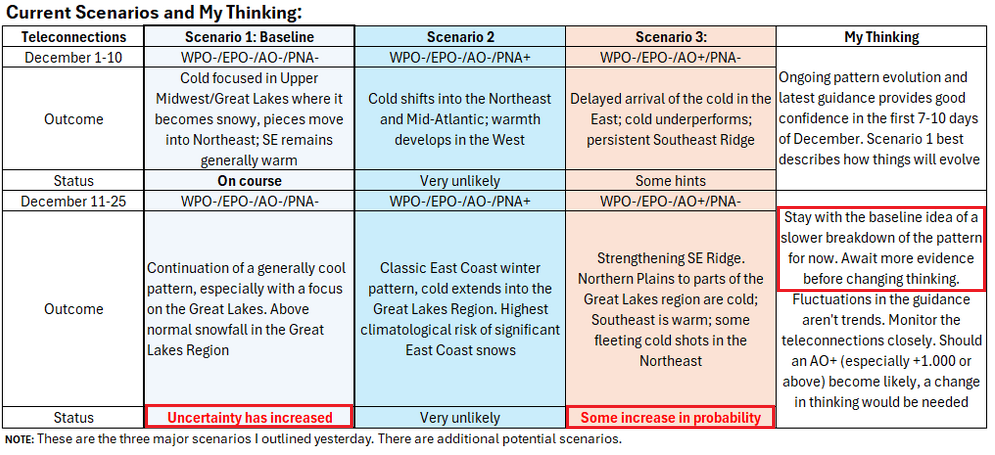
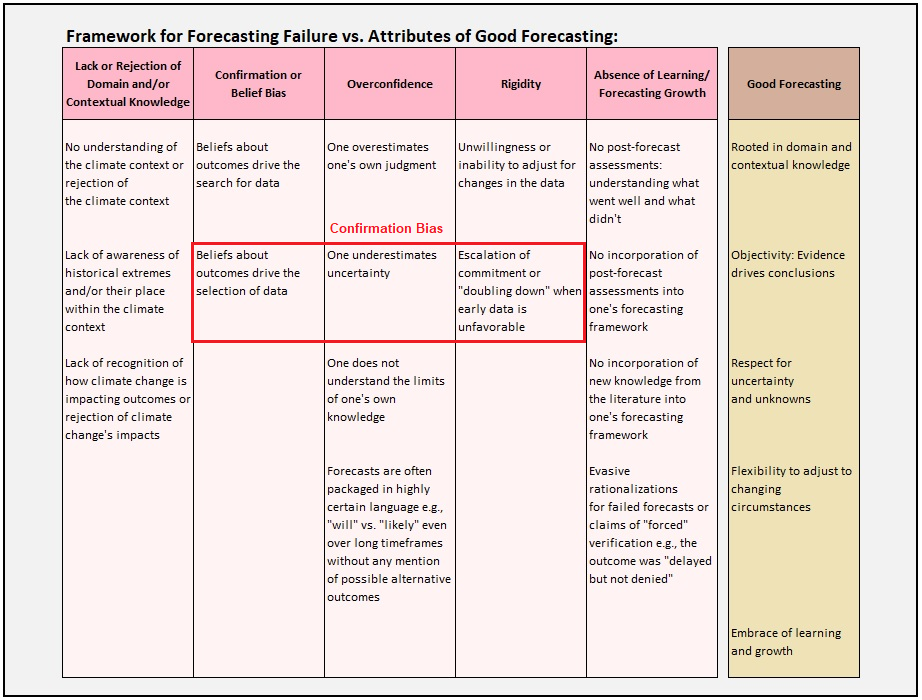
Several things: 1) There remains a lot of uncertainty how the stratospheric warming will propagate. Propagation could be a big factor in prolonging/strengthening or bringing back Atlantic blocking. 2) Even as stratospheric warming often (not always) propagates favorably to build or prolong/strengthen Atlantic blocking, one should not immediately dismiss hints of evidence to the contrary. Confirmation bias is bad for forecasting. Such evidence exists e.g., here's the AO forecast from the EPS 46-day forecast: Although the below table talks about considering climate change-related impacts on forecasts, I highlighted the section that relates to how and why confirmation bias skews forecasts: A systematic forecasting framework allows one to acknowledge such evidence while avoiding rash decisions from model noise. As I don't have a crystal ball to have 100% confidence in whether or not the above AO forecast will verify, I have made a note to continue to monitor developments. Needless to say, there is more to it than such a framework. Each scenario has clusters of outcomes (not discussed above). It should be noted that such frameworks don't guarantee accuracy, but they do reduce the risks that can otherwise lead to bad forecasts, especially when one is dealing with timeframes over which model skill is limited or worse. Finally, the 11/22 12z guidance has reaffirmed the December 1-10 idea. Indeed, more than half of the 11/22 0z EPS ensembles suggested 1" or more snow in Detroit and Toronto (a good signal for measurable snow prospects from this far out). I expect those figures to hold up with the 12z cycle.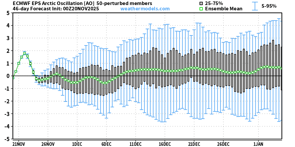
-
Its not guaranteed but the signals are looking good. Ensembles are still showing a favorable pattern. Op runs will still flip flop
-
Starting when? Favorable for cold outbreaks is a guarantee - Snowstorms are not a guarantee YET IMO ......Need blocking to set up
-
Exactly
-

Fall 2025 Medium/Long Range Discussion
Chicago Storm replied to Chicago Storm's topic in Lakes/Ohio Valley
As we know, there’s a multitude of ways it can fail (our recent history says it will), but you have to admire the look at least. -
.thumb.jpg.6a4895b2a43f87359e4e7d04a6fa0d14.jpg)
Central PA Fall Discussions and Obs
Yardstickgozinya replied to ChescoWx's topic in Upstate New York/Pennsylvania
Depressing but informative . -
Yes there is, the AO looks to go positive but it's only temporary then return negative or neutral state within the next two weeks. The weeklies also keep an negative EPO which did well last winter. I also don't think we are losing a negative EPO as all forecasts have it diving deeply negative some even have it below -4 sigma.
-

December 2025 Short/Medium Range Forecast Thread
Carvers Gap replied to John1122's topic in Tennessee Valley
The 12z Euro deterministic also kicks out the energy out of the Southwest. The EPS is a little slower to do so, but I am going to guess it does the same. Both the 12z GEFS and EPS have a formidable cold look now. The SER flexes are short lived. Just file this one away for later used. I would say 75% chance that what we saw yesterday was feedback across all modeling. It caused havoc downstream from that. I would suggest modeling in the d8-14 is still in the process of correcting. -
I always have hard time realizing that people are illogical. It like really evokes some nasty stuff when warm forecasts are mentioned, for what I would say is a majority.
-

2025-2026 ENSO
Stormchaserchuck1 replied to 40/70 Benchmark's topic in Weather Forecasting and Discussion
Actually the 12z GEFS looks completely different from the 0z EPS over the N. Pacific. It actually has a trough in the gulf of alaska where the EPS has a ridge. EPS has been doing better so far, but it's an interesting split. I would guess the 2 models are handling the MJO differently? -
2025-2026 ENSO
Stormchaserchuck1 replied to 40/70 Benchmark's topic in Weather Forecasting and Discussion
There is a lag -
December 2025 Short/Medium Range Forecast Thread
Carvers Gap replied to John1122's topic in Tennessee Valley
The 12z Euro has correct as well. Storms are kicking out of the Southwest as one would expect. Now that modeling is getting that fixed, we should see some downstream corrections. I would expect for something to track pretty soon. -
Seems like some utter nonsense talk about a possible AO and positive NAO . A major SSW favors, negative AO and negative NAO phases.
-

November 2025 general discussions and probable topic derailings ...
George001 replied to Typhoon Tip's topic in New England
I’m not entirely sure, but I’ve heard that guidance struggles the most during seasonal transition periods and during la Nina’s. The struggles during La Niñas I would think is because they are northern energy dominant, and models struggle the most with energy originating from the north as it’s very sparsely populated up there. We are currently in a seasonal transition period and La Niña conditions are present, so I would expect these struggles to continue. -
2025-2026 ENSO
Stormchaserchuck1 replied to 40/70 Benchmark's topic in Weather Forecasting and Discussion
Alaska is a big spot. Neutral or negative H5 is going to give you a warmer pattern pretty far north. If the ridge stays over Alaska (probably unlikely) the northern areas will be cold. I'm mostly talking about Dec 6-7-> -
0.3" here
-
Why be negative? Things change, you have to be able to change with it. "The MJO forecast way out in time" has done so poorly as a forecasting tool over the years.
-
2025-2026 ENSO
Stormchaserchuck1 replied to 40/70 Benchmark's topic in Weather Forecasting and Discussion
That's a +400dm mean ridge over Alaska for a 7-day period. Not really the same as the 1 panel you posted above. We are going to get a -EPO period but it's not going to be as strong or sustain like 2013. -
 .22 here. Sunny and warm now We lights


.png.6bb8dd0a4e7f2ec48ac7713a84abe502.png)


