All Activity
- Past hour
-
I definitely like a cold November, but w/ La Nina's of late....that rule hasn't played as fairly as year past. Probably has something to do w/ less see ice over the Arctic region. As for Nov, I think we start cold, warm-up during the middle 10 days, and cool back off. We may be able to get a normal month in terms of temps with that setup. Since months are kind of arbitrary in the grand scheme of things(30 day increments), I think if we can get a pattern of strong amplification w/ some troughs coming through...we should be good. Amplified patterns (as long as they aren't too crazy) work for much of the forum area. I just don't want the motherload of cold during November. That was kind of my main thought. I want a flip strongly to cold to begin winter. I think that is our best chance this winter(December). Then, we hope it returns. It is work noting Cosgrove strongly favors a backloaded winter and patience. I tend to see that as a Nino pattern, but he has some sound thinking, and really supports his ideas. Regarding this winter, I think for coastal areas, La Nina is no bueno. West of the Apps, we can score and score bigly. Kind of feast or famine like that Tennessee defense. I think we see chances at winter. Right around November 4th...strong signs of a big coastal.
-
150 mph winds are 150 mph winds, regardless of "source," plus the radial inflow and vertical winds in both types of storms (vertical motion exists in both kinds of storms) are far lower than the tangential/horizontal winds and I'm certain standing in 150 mph winds from either source will lead to injury or death. However, it is true that the rate of change of the wind speed in a tornado is usually greater than in a hurricane due to the shear/torque component of tornadoes and that can exacerbate damage, but the far bigger component is the actual horizontal wind speed. Also, Cat 5 hurricanes have a lot more mesoscale vortices than weaker hurricanes and these produce more turbulence/localized shear and can behave more like tornadoes.
-
Wonder how much longer that Montego Bay stream stays up? That northern eye wall is very intense on radar.
-

Major Hurricane Melissa - 892mb - 185mph
MonumentalNole replied to GaWx's topic in Tropical Headquarters
I am fairly confident in saying anyone covering the ground in Jamaica will not be able to find travel accommodations in order to get to Cuba in time. -

Major Hurricane Melissa - 892mb - 185mph
Wannabehippie replied to GaWx's topic in Tropical Headquarters
Battery power, satellite internet? -
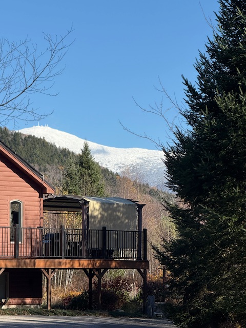
Gorgeous day
-

Major Hurricane Melissa - 892mb - 185mph
Wild Weather Monger replied to GaWx's topic in Tropical Headquarters
Montego Bay seems to be destined to be struck by the intense western eyewall.. Yikes. http://www.insmet.cu/asp/genesis.asp?TB0=PLANTILLAS&TB1=RADAR&TB2=../Radar/05Pilon/plnMAXw01a.gif -
So far, none of these locations have recorded a freeze... Next week was looking promising for Asheville but has trended much warmer.
-

Major Hurricane Melissa - 892mb - 185mph
TheDreamTraveler replied to GaWx's topic in Tropical Headquarters
Was thinking the same thing. We may have to anticipate and watch this happen all over again in a few days. Even if just a cat 4 it's going to be a disaster for Cuba so I hope the people covering Jamaica didn't burn themselves out when we focus on Cuba -
Looks like its about to get much worse there very shortly.
-
Yeah same vortices you see from top down
-
can't believe they still have power/internet
-

Major Hurricane Melissa - 892mb - 185mph
NorthHillsWx replied to GaWx's topic in Tropical Headquarters
Depending on structure when this gets back over water I’m not sure we don’t see another cat 5 landfall on Cuba. Environment is still extremely conducive until the Cuban landfall when shear will begin to increase -
The eye is slowly constricting as you would expect, but the remainder of the structure is holding together remarkably well considering the land interaction and high terrain.
-
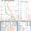
First time I have ever read an official forecast that suggests”wearing a helmet” holy smokes
-
SUMMARY OF 200 PM EDT...1800 UTC...INFORMATION ---------------------------------------------- LOCATION...18.2N 78.0W ABOUT 20 MI...35 KM SSW OF MONTEGO BAY JAMAICA ABOUT 230 MI...370 KM SW OF GUANTANAMO CUBA MAXIMUM SUSTAINED WINDS...165 MPH...270 KM/H PRESENT MOVEMENT...NNE OR 25 DEGREES AT 8 MPH...13 KM/H MINIMUM CENTRAL PRESSURE...899 MB...26.55 INCHES 165/899 There’s clearly NNE movement now.
-
2pm advisory still just below 900mb at 899 with 165mph max sustained.
-
Black River Hospital: https://x.com/dentona22/status/1983219897933975711
-

Major Hurricane Melissa - 892mb - 185mph
WxWatcher007 replied to GaWx's topic in Tropical Headquarters
-
Could be. I am not sure.
-
The airport hasn’t reported. Might be some sort of synthetic ob?
-
That gust report in Montego bay seems a bit high, they still got 20-30 minutes before they get into the eyewall based on Pilon, Cuba radar.
-
It looks like if it wasn't for that barely 70 degree high on the 19th, Central Park would have gone the entire second half of October without any days in the 70s of higher. In fact it was the only day with a high of 70 or higher since the 8th, when our mini torch ended. That's actually really impressive, especially when considering the background state we have to deal with.
-
bath water