All Activity
- Past hour
-
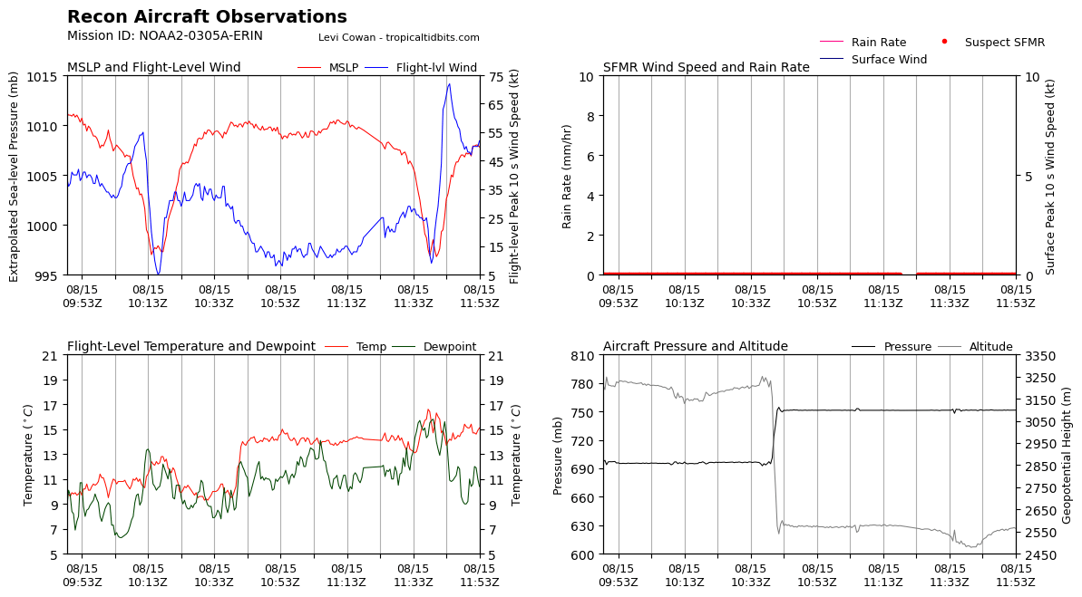
 KERMIT SAYS CLOSED EYE LADS Peak Flight-Level Winds: 75kt at 12:07z Peak SFMR: 65kt at 12:07z oval eye 19x27 nm wide 17.84N 54.77W 2C Delta a 10K-ft
 -

Central PA Summer 2025
Mount Joy Snowman replied to Voyager's topic in Upstate New York/Pennsylvania
Low of 70 with .45" of rain. Any storms that pop later today should come from the southeast. Love me some "opposite" storms. The only guarantee is that Lancaster will be in the bullseye ha. -
Not that late summer/early fall cold shots are always indicative of an incoming cold winter, I'd bet my retirement that most warm winters lack them. So decreasing the chance of a warm winter is always a step in the right direction at this point of the year imho.
-
Hope so. Summer's too short.
-
Gonna make a bold prediction the names Erin, Gabrielle, Humberto, Karen and Lorenzo will be 2025’s majors
-
2025 Atlantic Hurricane Season
BarryStantonGBP replied to BarryStantonGBP's topic in Tropical Headquarters
Gonna make a bold prediction the names Erin, Gabrielle, Humberto, Karen and Lorenzo will be 2025’s majors -
I haven’t weighed in on the great debate and I love summer, but the dog days are over and the step down is here. Still summer…but you know what’s coming next.
-
If right, it'll still go down as an Enso neutral winter since they don't include MEI or RONI...not that they shouldn't start considering them.
-
 Aug through two weeks (8/14) EWR: -1.2 NYC: -1.2 LGA: -1.9 JFK: -1.9
 -
Yeah MKX is really highlighting the potential for multiple rounds of rainfall pretty much every night from tonight through Tuesday next week, depending on where the mesoscale boundaries and such line up. This could get interesting fast around here, as thanks to last weeks rain we can't really tank a couple inches of rain again. And anything E of the Rock would be a huge concern given all the flooding in Milwaukee and fact that the rivers have mostly just fallen out of flood stage. These types of events with a stationary boundary sitting across the state have really hurt in the past (2018,2007). Hopefully it will not be to that level at all, but considering what happened lsat week I'm not all that confident to say the least.
-
Records: Highs: EWR: 99 (1988) NYC: 97 (1988) LGA: 97 (1985) JFK: 98 (1988) Lows: EWR: 54 (1964) NYC: 54 (1964) LGA: 59 (1964) JFK: 57 (1964) Historical: 1787 - Tornadoes were reported in Connecticut, Rhode Island, Massachusetts, and New Hampshire. Wethersfield CT was hard hit by the tornado outbreak. (David Ludlum) 1886: This tornado was estimated to be an F3 and moved northeast from 5 miles southwest of Newark, SD through town and into North Dakota. Only three buildings were reportedly undamaged at Newark, and a bartender at a saloon was killed. Three people died in two homes on adjoining farms two miles southwest of town. A saddle from a Newark stable was carried for a half mile. In North Dakota, homes and barns was damaged along the Wild River. (Ref. Wilson Wx. History) 1946 - Saint Louis, MO, was deluged with a record 8.78 inches of rain in 24 hours. (The Weather Channel) 1950: In 45 years of Hawaiian meteorological records, a hurricane had never affected the islands. On this date, Hurricane Hiki was moving north of the islands. Residents held their breath when the storm turned southwestward. Fortunately, the storm resumed its westward course and missed the islands. The highest wind speed recorded was at Kilauea Lighthouse, Kauai at 68 mph. (Ref. Wilson Wx. History) 1967 - The sundance fire in northern Idaho was started by lightning. Winds of 50 mph carried firebrands as much as ten miles in advance to ignite new fires, and as a result, the forest fire spread twenty miles across the Selkirk Mountains in just twelve hours, burning 56,000 acres. The heat of the fire produced whirlwinds of flame with winds up to 300 mph which flung giant trees about like matchsticks. (David Ludlum) 1969: Camille became a hurricane south of Cuba and entered the Gulf of Mexico as a major hurricane with winds of 115 mph. (Ref. AccWeather Weather History) 1971: Some of the worst flooding that ever occurred in western north Texas happened on this date. Heavy rain began on the 14th, but the worst of the rain and most of the flooding was on this date. On that day, rainfall amounted 4 to 11 inches. The Wichita River, on the northwest side of Wichita Falls, TX crested at its highest level in 30 years. At least 10 families were forced to evacuate their homes along the river as the waters rapidly rose. The river also rose so high that its swift-flowing waters undercut several streets, causing them to collapse. The official rainfall at the National Weather Service Office in Wichita Falls was 4.52 inches, making this the wettest August day ever observed in the city. (Ref. Wilson Wx. History) 1977: Lightning struck a cement well covering near Mankato, MN, causing shattered pieces of concrete to be blown over 30 feet, damaging cars. (Ref. AccWeather Weather History) Hurricane Doreen tracked north-northwest along the west coast of Baja California, dissipating over the coastal waters. Areas of southern California received at least two inches of rain with up to 8 inches in the mountains on this date through the 17th. Debris flows and flooding from Henderson Canyon into the Borrego Springs De Anza area damaged 100 homes. Mud flows grew to five feet deep. Flooded roads resulted in desert areas. Four people died and damage was set at $25 million dollars. (Ref. Wilson Wx. History) 1979: Early season chill across the Midwest and East produced record low temperatures for the date including: International Falls, MN: 33°, Grand Forks, ND: 36°, Madison, WI: 37°, St. Cloud, MN: 39°, Fargo, ND: 43°, La Crosse, WI: 43°, Dubuque, IA: 45°, Peoria, IL: 45°, Indianapolis, IN: 45°, Mansfield, OH: 46°-Tied, Moline, IL: 47°-Tied, Akron, OH: 47°- Tied, Youngstown, OH: 47°-Tied and Cincinnati, OH: 49°. (Ref. Wilson Wx. History) 1983 - Hurricane Alicia formed on this day and was the costliest tropical cyclone in the Atlantic since Hurricane Agnes in 1972. It struck Galveston and Houston, Texas directly, causing $2.6 billion (1983 USD) in damage and killing 21 people. This storm was the worst Texas hurricane since Hurricane Carla in 1961. Also, Alicia was the first billion-dollar tropical cyclone in Texas history. 1987 - Thunderstorms developing ahead of a sharp cold front produced severe weather in the Upper Midwest during the afternoon and evening hours, with Minnesota and eastern South Dakota hardest hit. A thunderstorm in west central Minnesota spawned a tornado at Eagle Lake which killed one person and injured eight others. A thunder- storm in eastern South Dakota produced softball size hail at Warner. (The National Weather Summary) (Storm Data) 1988 - Thirty five cities in twenty states in the north central and northeastern U.S. reported record high temperatures for the date, including Lamoni IA and Baltimore MD, where the mercury hit 105 degrees. Temperatures 100 degrees or above were reported in twenty-two states. Pierre SD was the hot spot in the nation with a high of 114 degrees. Bluefield WV reported eight straight days of record heat. (The National Weather Summary) 1989 - Evening thunderstorms in eastern New Mexico produced wind gusts to 66 mph at Clovis. Evening thunderstorms in West Texas produced baseball size hail around Hereford, Dimmitt, Ware and Dalhart. (The National Weather Summary) (Storm Data) 1993: Slow moving thunderstorms produced torrential rain across Mower County, MN. Rainfall exceeded 4.00" over most of the county with the highest total of 10.25" at Adams, MN. Significant flooding occurred within the city of Austin, MN, where 1,000 homes suffered water damage. The Cedar River in Austin rose rapidly out of its banks through the day. It crested at 21.3 feet, 6.3 feet above flood stage. (Ref. Wilson Wx. History) 1994: Tropical Storm Beryl formed in the northeast Gulf of Mexico and moved slowly east northeast, crossing the Florida panhandle coastline near Panama City. Beryl greatly added to the woes of people who were still recovering from Tropical Storm Alberto in July. At landfall the maximum sustained wind was estimated at 60 mph. The greatest rainfall total of 10.69 inches were observed at Apalachicola, but higher values likely occurred to the east of this location. Beryl weakened to a tropical depression as it moved northeast into extreme southwest Georgia at early on the 16th. There were no deaths and only 1 injury directly attributable to Beryl and damage was estimated at $5.9 million dollars. (Ref. Wilson Wx. History) 2004: Severe flooding in Death Valley National Park in California caused extensive flooding. The flooding completely washed away several miles of roadway and caused damage to several rest areas. Two people traveling along Highway 190 were caught in the flooding and killed. Damage was estimated at $20 million dollars and took 3 months to completely repair the damage. (Ref. Wilson Wx. History) (Ref. WxDoctor)
-
2025 Atlantic Hurricane Season
BarryStantonGBP replied to BarryStantonGBP's topic in Tropical Headquarters
Oi kev did ya check the ec aifs on that one lad -

Occasional Thoughts on Climate Change
donsutherland1 replied to donsutherland1's topic in Climate Change
This was a very important paper--perhaps one of the most important weather/climate papers that will be published this year. It describes the mechanism by which climate change is driving Southwest aridification via marine heatwave-induced changes to the PDO. -

2025 Atlantic Hurricane Season
Kevin Reilly replied to BarryStantonGBP's topic in Tropical Headquarters
I guess we should ignore the direct strike at Daytona beach in 11 days August 26th? -
It got better yesterday.


-
OI OI LADSSSSSS

-
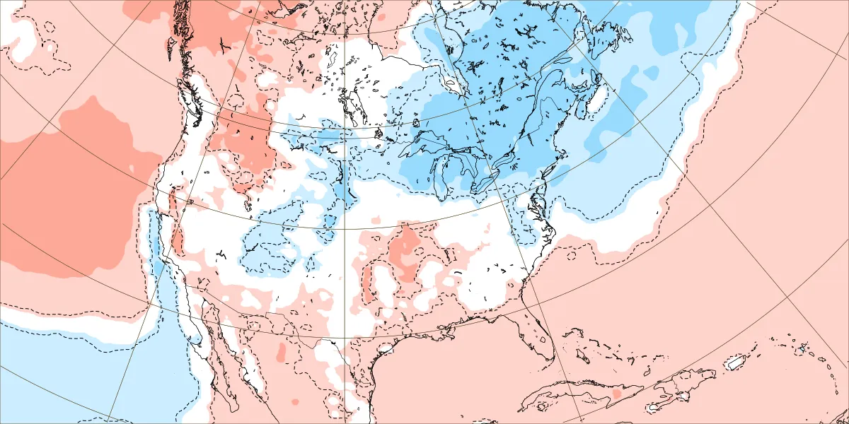
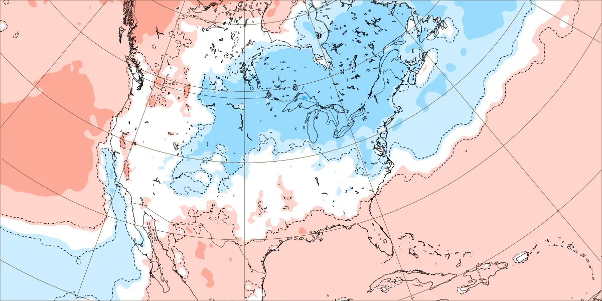
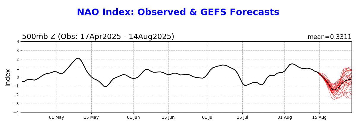
The GEFS and EPS are finally starting to digest a -NAO developing as Erin makes closest pass to CONUS. This is best seen in the increase in number of individual members slowing down and well west of the mean. Surface HP also now shown building in SE Canada. I am still watching for interest in how this all unfolds, because I do think the simple wide right recurve is amiss in this regard—it doesn’t fit the developing pattern.

-
OI LADS GTFIH 71KT FL 120730 1816N 05500W 6966 03142 0038 +088 +076 135072 075 065 004 00 120800 1817N 05459W 6963 03150 0054 +081 +079 137070 075 061 005 00
-
79 / 67 . Continued warm, partly cloudy. Isolated showers mainly South/West, Mid 80s to 90 in the hot areas. Weekend looking great for i think mostly 4 in a row now. Split warm saturday mid 80s / upper 80s , Hot / Humid Sunday low - mid 90s, perhaps some 96,97 in the hottest areas, only isolated showers ot storms possible. Onshore flow Monday NE flow keeps it coolers upper 70s / low 80s or perhaps some midnight/1Am highs Sunday overnight into Monday. Erin hooks northeast mid week. Week is near normal overall with onshore flow and scattered showers Wed/Thu mainly west of the areas as forecast. Warmer by the end of the week and into next weekend briefly with perhaps next shot at 90 Sat or Sun. Ridge west trough into the GL/NE with cooler period the following week. Ridging coming east by the close of the month with warmer - hotter flow. 8/15 - 8/17: Warm - Hot/ Humid - Heat Sunday - only isolated/scattered storms 8/18 - 8/22 : Near normal - cooler than normal Erin east 8/23 - 8/24 : Warmer weekend perhaps a 90 in the hottest areas 8/25 - 8/28 : Cooler 8/29 - Beyond : Ridge builds warmer / hotter flow
-
are people overhyping sinking and dry air? CAM ON ERIN!
-
Had several days in the 90s here. At least the week heading into Labor Day looks to warm up.
-
The advisory also said a brief td is possible
-
Last week of the month may try to evolve warmer ...kind of a newish telecon signal.
-
Already not liking the darker earlier mornings and the earlier sunsets...both very noticeable now and it's getting depressing. Not looking forward to the dark by 4:00...unless its snowing out. The thought of having a a snowstorm ongoing and its like 4:30 PM and already dark but its so peaceful and calm with heavy snow is very soothing.
-
any concerns with your well?