All Activity
- Past hour
-
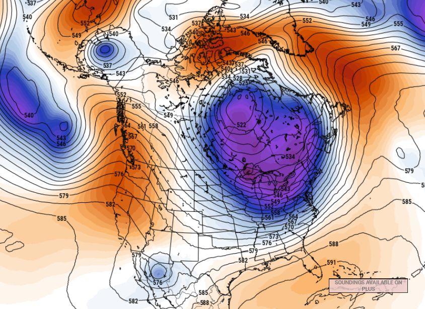
it's a winter pattern in the curvature/geometric orientation, but doing so with spring hydrostatic and non-hydrostatic heights. It's been this way all spring all spring. 80 F? doesn't matter... that's just the higher relative hydro and non hydro heights, but when you have this coherent background/non-linear forcing to always look like this or similar to it (below) as your resting/return state ... you're in winter:
-

Central PA Spring 2026 Discussion/Obs Thread
Mount Joy Snowman replied to Voyager's topic in Upstate New York/Pennsylvania
Low of 41. Rain totals again being cut back down this way for tomorrow. -
Ha, it’s like legit snowing now.
-
My Wisteria browned out, my hostas look like they were scorched. Worst freeze in 20 years for tree fruits and the wine industry from VA through the northeast.
-

2026-2027 Strong/Super El Nino
bluewave replied to Stormchaserchuck1's topic in Weather Forecasting and Discussion
The sensible weather in any given location is a function of the global temperatures which sets the range of options. It’s why the CONUS winters have shifted so much warmer after 2014-2015 compared to before. This is why your area in the Great Lakes hasn’t been able to experience a repeat of the 2013-2014 winter following the big global temperature jump in 2015-2016. Same for Central and Eastern PA not being able to experience a repeat of 1993-1994 benchmark for snow and record cold. Along with NYC Metro not seeing anything close to 1995-1996. It’s no coincidence that those two benchmark winters occurred before the first big temperature jump in 1997-1998. The climate state from 1997-1998 to 2014-2015 also produced benchmark winters for Boston in 2014-2015 and DC to Philly in 2009-2010 which haven’t been able to be replicated. Following the 2023-2024 temperature shift to warmer weather we experienced the #1 warmest winter and #2 warmest winter for the CONUS only two years ago apart. Even a relatively small temperature shift to warmer in the 1980s hasn’t allowed a top 10 coldest CONUS winter to happen again like we had in the 1970s. So every temperature jump has resulted in some aspect of the prior climate not being able to occur in the new warmer one. But we usually have to wait until after one of these jumps to start observing which elements of the earlier climate state haven’t been carried forward into the newer one. -
Mins this morn…lots of sub freezing temps in the valleys and north.
-
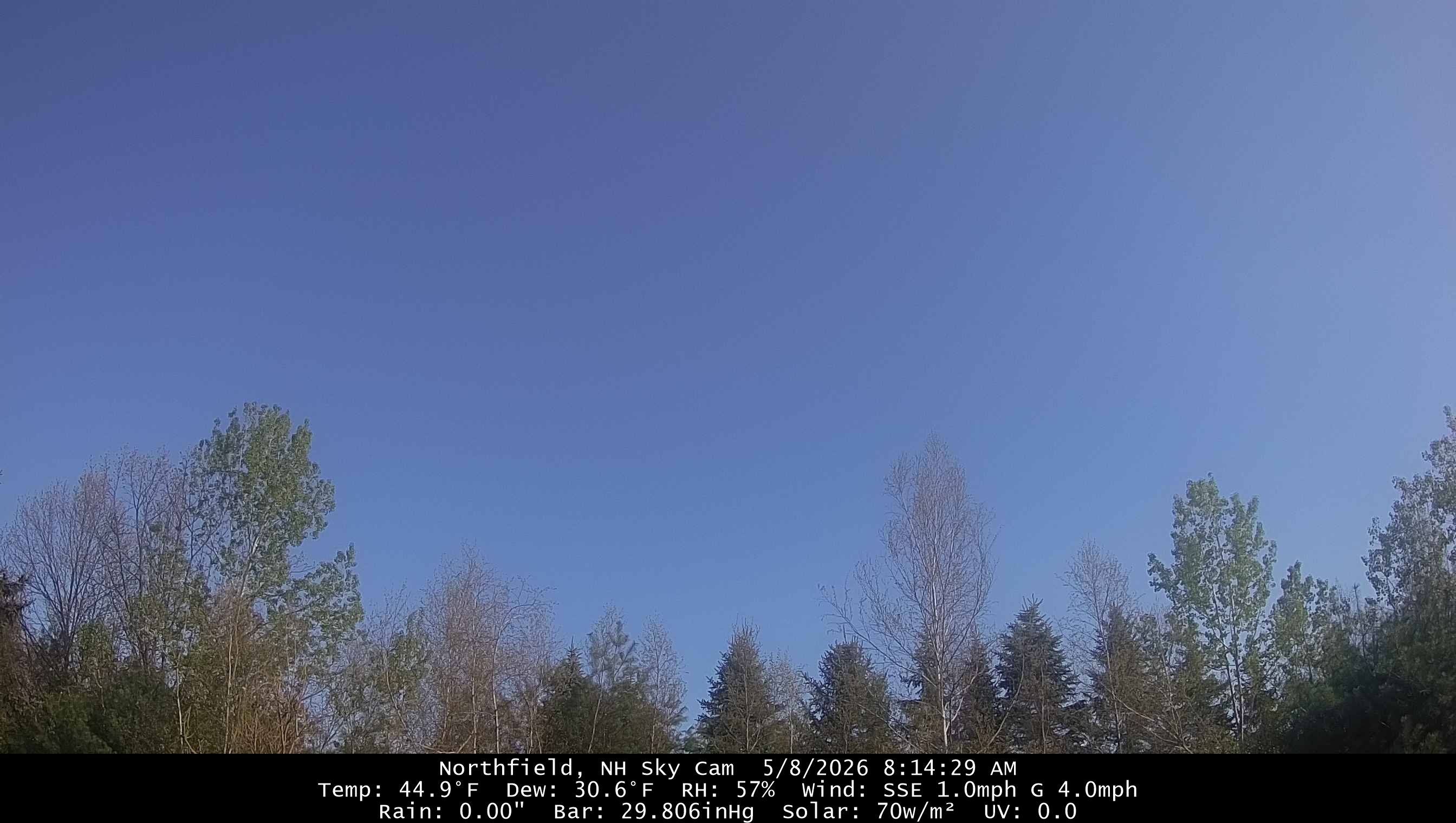
30.3 with FROST at 6:15.
-
I'm with you. Low of 31° here. I'm so done with it.
-
-
(002).thumb.png.6e3d9d46bca5fe41aab7a74871dd8af8.png)
Central PA Spring 2026 Discussion/Obs Thread
ChescoWx replied to Voyager's topic in Upstate New York/Pennsylvania
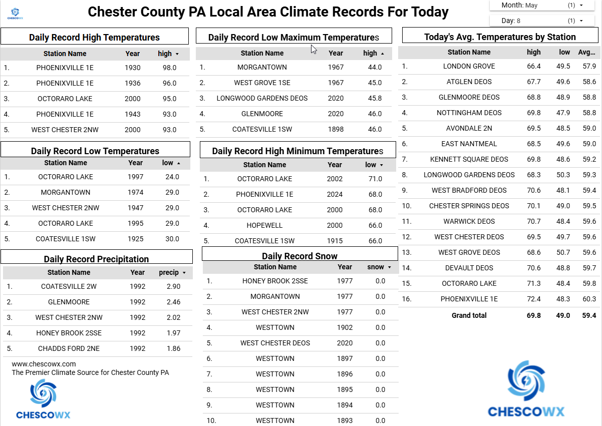
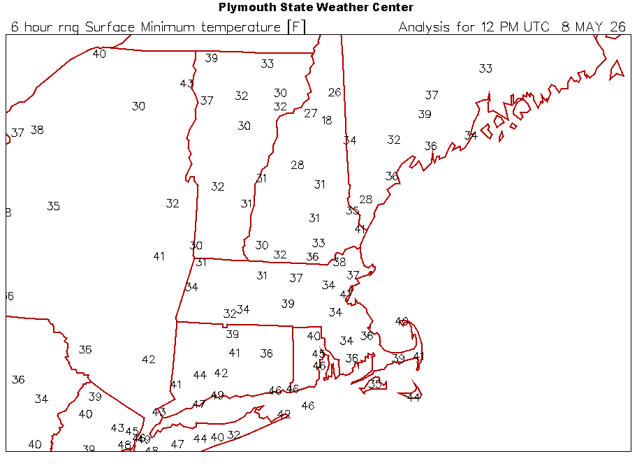
Minimum temperatures this morning were 8 to 14 degrees below normal for today’s date. The lowest was our typical cold spot in Warwick Twp with a low of 35.5. With the exception of Sunday, where temperatures will be close to normal with highs in the low 70’s we should see well below normal temperatures continue for at least the next week. Rain chances increase tomorrow morning into the afternoon. We should see a mostly sunny Mom’s Day on Sunday before more rain arrives Sunday night into Monday. Some models are hinting at almost an inch of rain between Saturday and Monday night.
-
E PA/NJ/DE Spring 2026 Obs/Discussion
ChescoWx replied to PhiEaglesfan712's topic in Philadelphia Region
Minimum temperatures this morning were 8 to 14 degrees below normal for today’s date. The lowest was our typical cold spot in Warwick Twp with a low of 35.5. With the exception of Sunday, where temperatures will be close to normal with highs in the low 70’s we should see well below normal temperatures continue for at least the next week. Rain chances increase tomorrow morning into the afternoon. We should see a mostly sunny Mom’s Day on Sunday before more rain arrives Sunday night into Monday. Some models are hinting at almost an inch of rain between Saturday and Monday night.
-
Overcast, 44°.
-
E PA/NJ/DE Spring 2026 Obs/Discussion
ChescoWx replied to PhiEaglesfan712's topic in Philadelphia Region
Nice write up! our climate has always and will always move in cycles. Of note with May likely to end with below normal temperatures - this will mark 7 of the last 10 months with below average temperatures here in Chester County. -
Light snow/flurries up here at 1,500ft base of ski area, ha. Phenomenal.
-
Step 4 would be a displaced Polar Vortex caused by SSW which played a huge role in the extended cold snowy outbreak(s) this past winter. Also the colder than normal persistent sea surface temps off the coast would help.
-
Yeah we have started with some stuff and it was really just this week, but still largely sticks especially just out of the valley floor above 1,000ft. I can tell it’s about to explode though. Feel like we need another 1-2 days of sun and mild and it would go full green everywhere.
-

Central PA Spring 2026 Discussion/Obs Thread
mahantango#1 replied to Voyager's topic in Upstate New York/Pennsylvania
- Today
-
The 80s on Tuesday made a huge difference here. Trees started leafing out, fruit trees are flowering, and the catbird, orioles, and hummingbirds have returned. It just looks and sounds different out there.
-
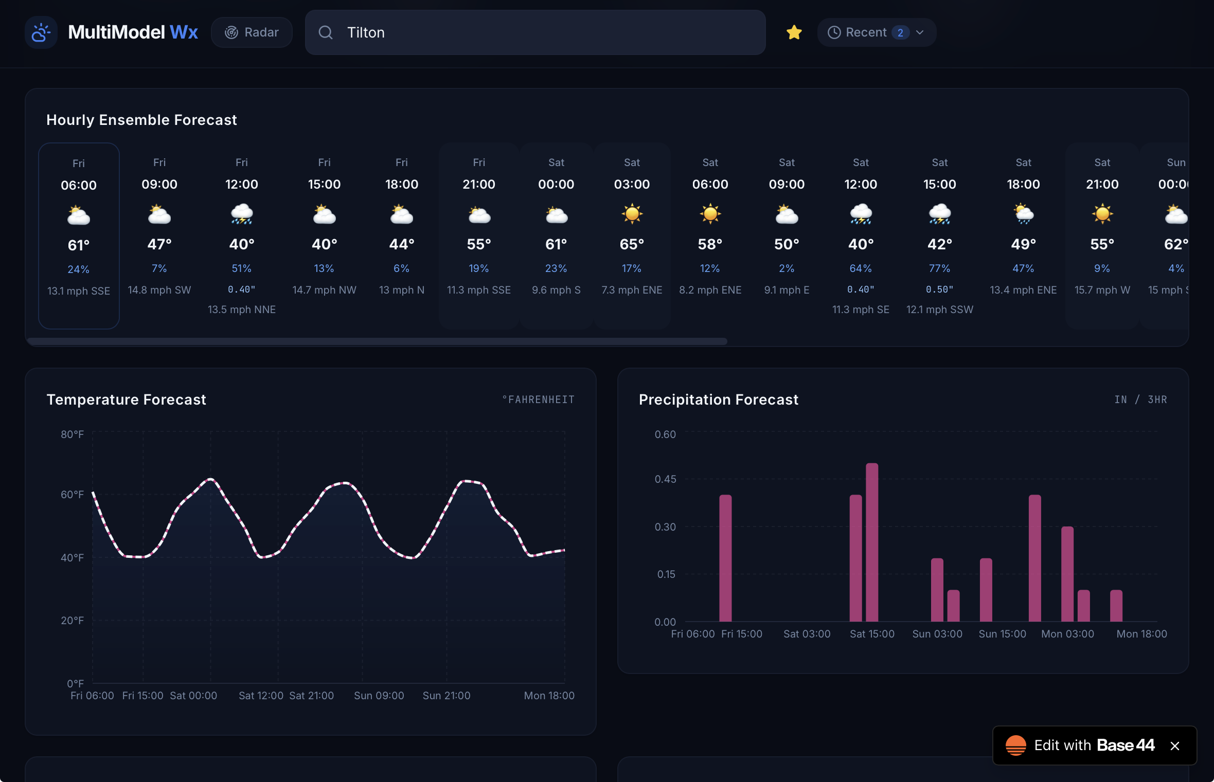
A little better, but still seems too high compared to modeled 2m temps. What’s up with those times too? Max temps are 03:00 and mins closer to 12:00 or 15:00.
-
Low was 36.0 degrees, currently 37.1/32.8 degrees at 7:30 am with clear skies.
-
32F… kind of has a November vibe with not much greenery and still stick season. Weird with the long daylight though. Bring back the 70s.
-
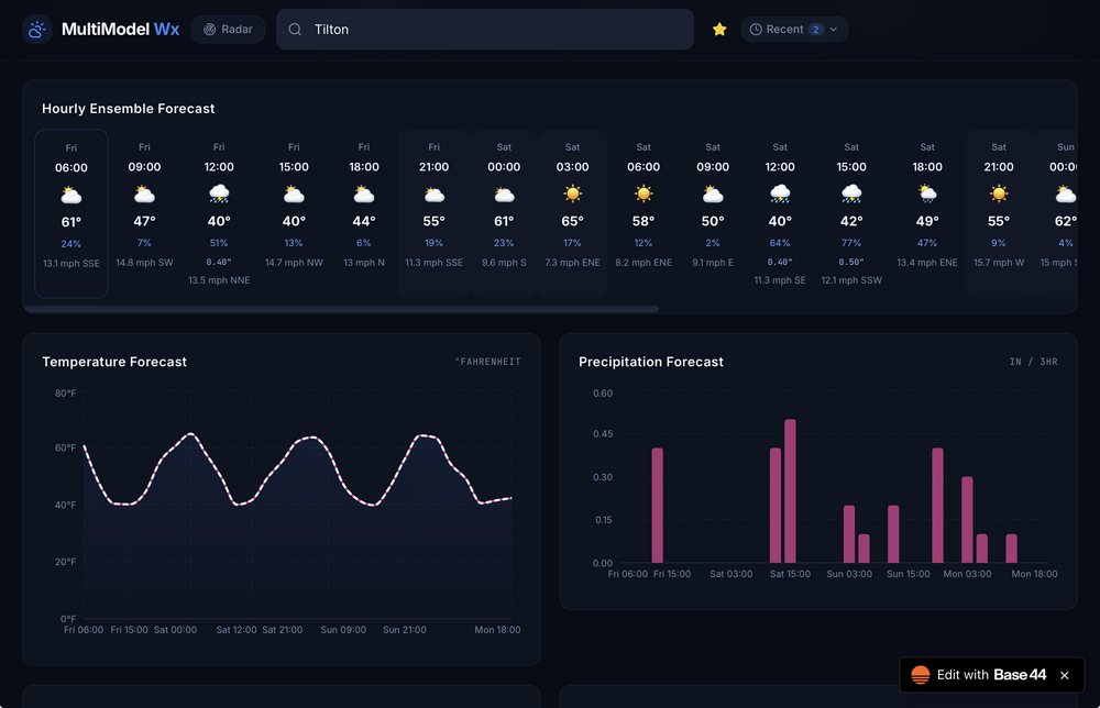
Try now https://synoptic-weather-lens.base44.app
-
There are a few types of plants that are looking weak due to disrupted development from that freeze. Some don't really show it but, because they started flowering and the flowers froze they won't be fruiting and seed production will be severely reduced.
-
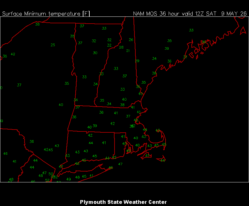
MOS mins for tomorrow AM. Cutting it close with the potted plants in the driveway.

-
Working on it