All Activity
- Past hour
-

Central PA Winter 25/26 Discussion and Obs
Jns2183 replied to MAG5035's topic in Upstate New York/Pennsylvania
It's been 60-70 around Xmas here a few times. That a torch Sent from my SM-S731U using Tapatalk -

December 2025 regional war/obs/disco thread
WinterWolf replied to Torch Tiger's topic in New England
Ahh at this point, it’s(Xmas) far out there…Tuesday is the priority for me. Let’s get that in focus first. But that’s just my opinion. -

December 2025 Short/Medium Range Forecast Thread
Holston_River_Rambler replied to John1122's topic in Tennessee Valley
I got this one from the NCEP reanalysis site for todays date in 1995: -

December 2025 regional war/obs/disco thread
Damage In Tolland replied to Torch Tiger's topic in New England
Too much Shabbs in your head -
December 2025 Short/Medium Range Forecast Thread
Holston_River_Rambler replied to John1122's topic in Tennessee Valley
We desperately need to fill up the thunder in the mountains index. There is hope tonight. -

E PA/NJ/DE Winter 2025-26 Obs/Discussion
Birds~69 replied to LVblizzard's topic in Philadelphia Region
Yep, pretty sure. I don't think I'll make it through the night. Anywho, cool temps, rain and the poor air quality screams relief....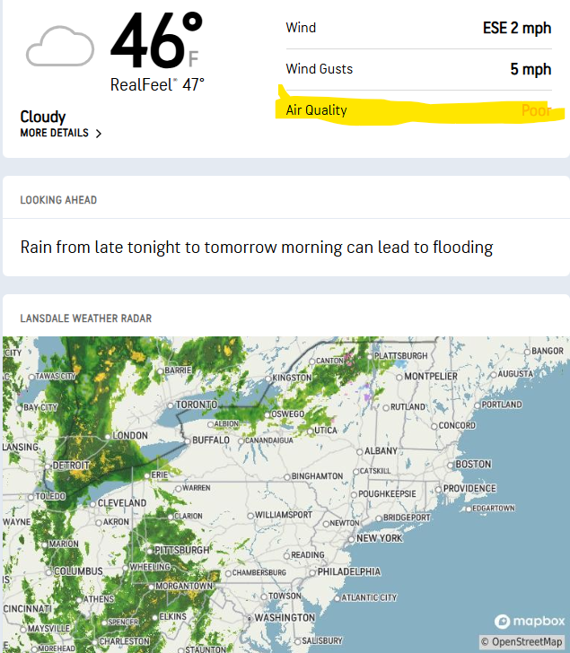
-

December 2025 Short/Medium Range Forecast Thread
Daniel Boone replied to John1122's topic in Tennessee Valley
This is this day in 1995 Plymouth State Weather Center Compare to Christmas then : Plymouth State Weather Center I know it just shows Site link but it goes directly to Map. -
Not stealing any joy, just saying what it shows. Hopefully it’s all further south.
-
December 2025 regional war/obs/disco thread
WinterWolf replied to Torch Tiger's topic in New England
That will happen Monday/Monday night lol. -
December 2025 regional war/obs/disco thread
WinterWolf replied to Torch Tiger's topic in New England
Don’t let them steal your joy…this is the problem with social media. Would anybody not enjoy a 75-80 degree day in mid April…because two or three days later it’s gonna rain and be 41? Of course not. Enjoy the moment…f**k what comes later on. -

December 2025 regional war/obs/disco thread
SouthCoastMA replied to Torch Tiger's topic in New England
I'd like to see the 23rd come in a bit more robust and further south on other guidance like the Euro has had for a few runs, now that we are within 5 days -
As advertised the Pacific is hostile on the means for the foreseeable future. We shall see if that verifies. It might not. If it does, what can 'save us' from a shit the blinds period to some degree is a favorable NA. In general the guidance indicates we may get that, but we just cant know yet. Just roll with it man. Keep monitoring. Have fun with it. This isn't life and death shit lol.
-
December 2025 regional war/obs/disco thread
WinterWolf replied to Torch Tiger's topic in New England
7 days out. -
Europe has not been cold in seemingly forever in winter. Thats the pattern that really gets them cold, though they did well in 09-10 and 10-11 (early) with a W based -NAO, overall the e based one is better though.
-
Yeah this just is not a cold pattern for the west at all really. The Bering Sea ridge and subsequent trof are too far west. Its a fine line for them, a 700 mile shift east would produce December 1990 results for them but as of now too much Pac air is getting into that trof so they're just not cold and won't be any time soon
-
December 2025 regional war/obs/disco thread
SouthCoastMA replied to Torch Tiger's topic in New England
got em -

E PA/NJ/DE Winter 2025-26 Obs/Discussion
RedSky replied to LVblizzard's topic in Philadelphia Region
Swine flu -
December 2025 Short/Medium Range Forecast Thread
Daniel Boone replied to John1122's topic in Tennessee Valley
Yeah, la nina augmented you might say. Nina actually strengthened a little recently after a steady weakening. Should see a rather fast weakening from here on. I think i'll go back and look at some NPAC Charts from 95-96 and see how or if the AR was prominent then. -
Dammit Chuck, stop canceling winter!! We need a good vibe up in here. Read the room.
-
25
-
It’s all guidance at 12z.
-
Cold front passed through the area earlier this afternoon, with (convective) rain showers accompanying it, which helped to transport higher winds down to the surface. Peak wind gusts of 48MPH at ORD, 52MPH at MDW, and 41MPH at RFD.
-
Solid sunset a short time ago at ORD…
-
December 2025 regional war/obs/disco thread
Damage In Tolland replied to Torch Tiger's topic in New England
It’s like no one is allowed to enjoy the potential snow Tuesday because an op run shows a day of 38 rain on the 26th. Wild -
December 2025 regional war/obs/disco thread
WinterWolf replied to Torch Tiger's topic in New England
Well you know, we gotta have the stoking of the fire. And then the nellies chime in etc etc…it’s how it goes around here unfortunately. Xmas is a week out, but yet we have folks telling us what it’s gonna do on Xmas already.


