All Activity
- Past hour
-
Yes
-
0.70” for the day. 5.22” for the month. Am not looking forward to the excessive heat.
-
The highs in the area were 93-95. But that tells only some of the story as the dewpoints/RH made it feel like ~100-102. I had to go into a house whose AC is broken. It was 91 inside and this was at 8PM. I was soaking wet within 5 minutes!
-
Absolutely no wind but sky is still constantly lit up, rolling thunder and a close cg bomb every 5 minutes still after 70 mins. Picked up nearly 3" of rain last hour. Storms don't look like they are moving much as Erick remnants keep throwing moisture in. Dry air is off to northwest and losing. This storm has ruined me for life I'm afraid. Sent from my SM-G970U1 using Tapatalk
-
Pretty underwhelming here, just some moderate rain at best. I feel like the strongest severe storms pop up on days when there's less risk. Today I think we were in enhanced. It's not like we need the rain anyway. Breeze kicking up now and can already notice a significant drop in humidity.
- Today
-
Yeah—I’m just talking about 100° in June. That seems far more rare. I only see 1952 and 1964 on NOWData. There was a 99° on 5/26/2010 from what I see. Assuming something doesn’t muck it up, next week looks pretty anomalous for this time of year.
-
Only 0.17" here today.
-
I had towers go from 0 to almost -70c in minutes. The low cloud base right over bay made almost all strikes positive cg Sent from my SM-G970U1 using Tapatalk
-
After tonight I'm embarrassed I ever thought thunder by us was loud. Being in a high rise overlooking bay/ocean when outflow boundary hit old boundary just after dark, I had basically multiple close strikes every 2-2 seconds for 10 minutes so that it felt like the whole hotel was shaking and it was blue daylight outside. We had to cover our ears it was getting so loud. It was torrential rain and we could not hear it the first 15min. I feel like I was a virgin until tonight. Sent from my SM-G970U1 using Tapatalk
-
And just like that, it's over...
-
And now I'm getting an "f you" cloudburst just to finish it off...
-
Bad day for storms locally but a good day for learning and mulching. Atleast now that I found some of these tools it's much harder for someone to say it's black when it's really white, theoretically of course lol. Not that anyone here would do such a thing.
-
They were last at 100F in 2019. They reached 103F in 2011.
-
This makes me sad. I've had tons of gray tree frogs every spring for the last 20 years or so. This year I have not heard a single one. I wonder what would cause a large population to disappear so suddenly?
-
The only time I can find BDL hitting 100° in June is 6/30/64. Would be impressive if it happens next week.
-
I thought you said it would be interesting lol. There was definitely a lot of anx among our local forecasters yesterday about exactly where storms would Initiate. I said yesterday my hopes were a little different than my expectations but i'm not afraid to share them both.
-
So my grand total for today's stormy environment? 0.00" Not one drop. The pre frontal stuff hit south of Quakertown. Round one hit south of Allentown. This last round missed to the north, getting the Scranton area.
-
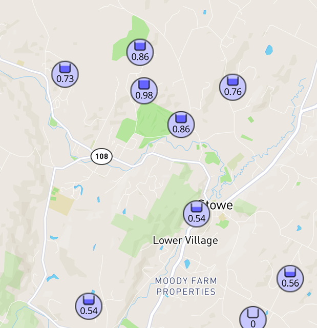
We had a good soaking, with standing water or soggy conditions in numerous areas of a 3-mile loop with the dog. The neighbor across the street along Stowe CC had 0.86” today in three quick moving downpours. The top of the golf course 200-300ft higher had 0.98”. Looks like the Lower Village and SE had just over a half inch. I appreciate how this area has so many PWS stations in a very small radius. Its always interesting how even 1 mile can add 0.30” of rainfall in these convective situations.
-
Everything split around us at the golf course tonight. Not a drop of rain.
-
Yep. Been a cacophony of them for the past week or so. Thankfully the whoosh of the AC drowns them out.
-
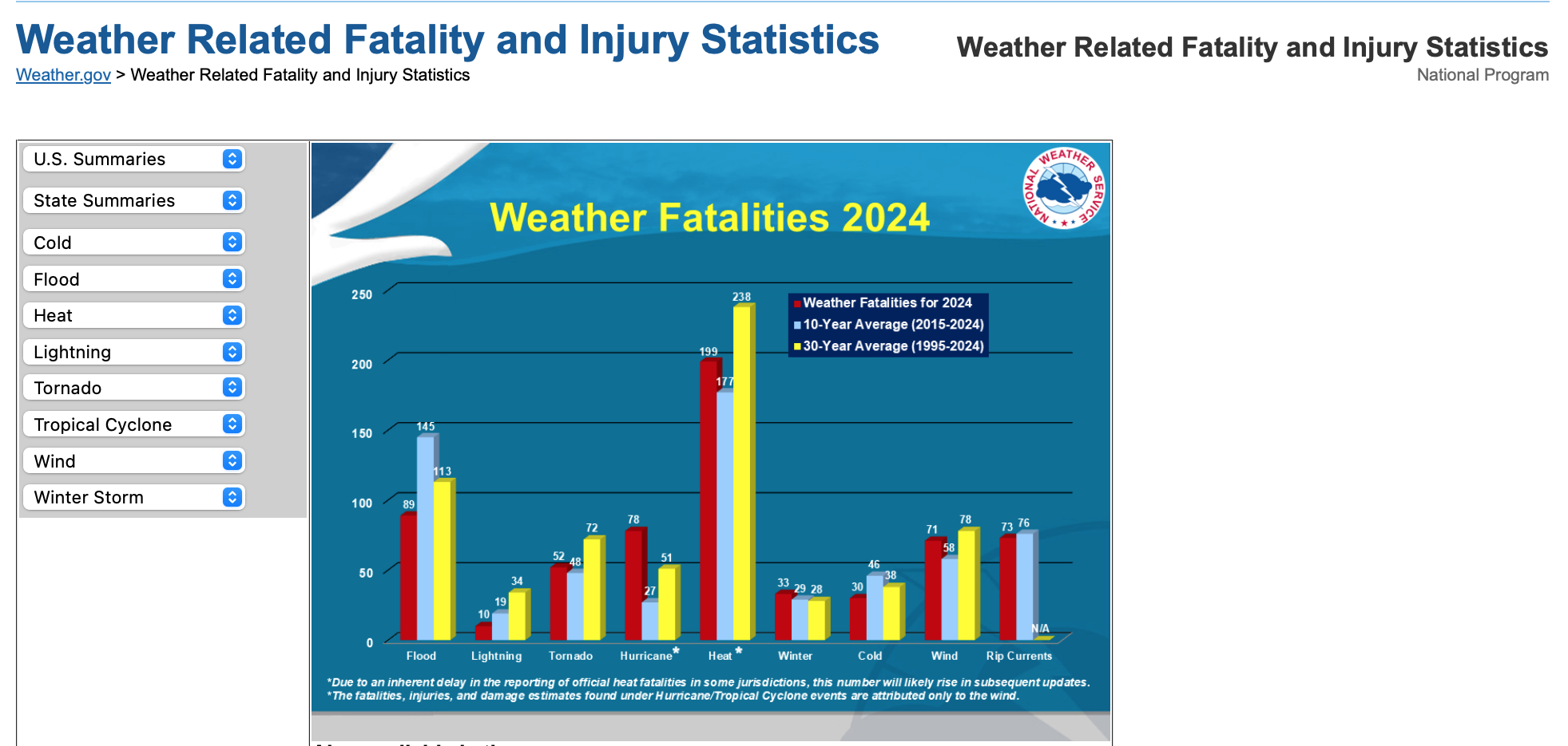
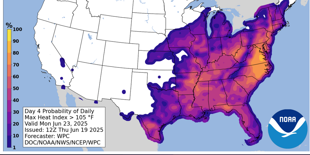
 Model guidance (especially European) for days has been forecasting 100 degree heat, with the potential suppressants being early developing daily sea breezes and/or thunderstorms-clouds debris. While severe storms cause damage, excessive heat can cause fatalities if not properly prepared. Please follow NWS guidance and advise of local officials-cooling centers, hydrating etc as this heat wave develops. The Heat Wave 'may' break next Thu-Fri before reasserting for another opportunity at 100F next weekend - June 28-29. June record stats in the 90+ year Period of Record (POR)... 100+. Newark 2 days, NYC CP 1. Yearly warmest 3 day max temp period ever in Newark over the 90+ period of record. We MAY??? crack top 10. See attached graphic. Added Preparedness statistics graphic...believe--especially urban centers which may not cool below 82 degrees Monday and Tuesday nights. HEAT on average is the highest fatality hazard. WPC statistical probability of MAX HI on the 23rd is added... from the graphic you can see that is a 50-70% chance in the interior. post completed 1105PM/19
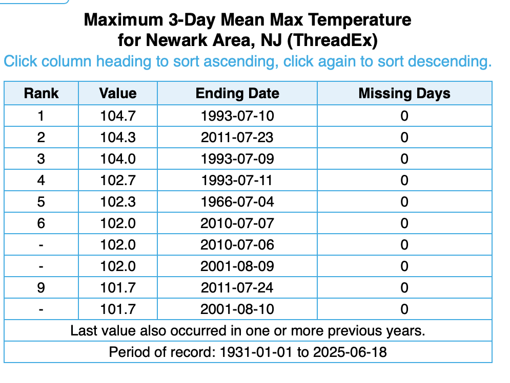
-
Headlines up
-
Power out since 5 and tree down on a car with the wires but just 107 total outages so a small number and we are low priority. Plus it’s a Thursday holiday. The huge tree on University about 3 weeks ago put 900 out and we got prompt attention on that
-
Was in D.C. area this afternoon, numerous trees down and some unfortunately on cars that were on the roadway. Meanwhile back home 88 for a high.
-
Looks like dew points temps maxed out at 75/76 is the highest i see today. Slowly dropping now into the upper 60s.


.thumb.jpg.6a4895b2a43f87359e4e7d04a6fa0d14.jpg)