All Activity
- Past hour
-
Maybe they left their grass really high? I'm only half kidding. Im sure that there aren't a lot of us with a snow ruler using a snowboard. I also get the sense that there's a fair amount of snow envy out there so I wouldn't be surprised if some people report late after seeing what's in their area and then jack potting themselves. I don't envy you trying to weed out the bullshit measurements but it's appreciated.
-
We’re not that far from a white Christmas. 150 miles more south?
-

December 2025 regional war/obs/disco thread
Ginx snewx replied to Torch Tiger's topic in New England
Oh boy oh boy -
We need to stop comparing today to 35+ year old analogs. The climate has changed drastically. There are way too many variables in play today vs then.
-
Grades but that was close.. to the south of us gets nailed
-
6z Gfs wants to ruin Christmas with zr/ip. It'll probably keep pushing cold south until Chill wins again. Lol
-
6Z Gfs trying for Christmas day now
-
Some better trends overnight. Still don’t like the pattern overall, it the 11-15 day featured a good ridge poking into Greenland. Still hope for Christmas.
-
Not much but it will do
-
Christmas saved for all of SNE on the 6z GFS
-
GFS trying to change over here at the end Friday.. it would be nice to get a coating after losing it all
- Today
-

2025-2026 ENSO
Stormchaserchuck1 replied to 40/70 Benchmark's topic in Weather Forecasting and Discussion
Yeah, look at how there is consistency. This is what I would expect. Usually the Winter pattern sets up in Nov/Dec and persists. In the Pacific the Winter pattern can even set up as early as Sept/Oct. If the atmosphere is Nina-like right now, I don't see why it would be +PNA in Jan, although 7 of the last 7 is like a 1:25 random type of thing. The 384hr ensemble means still have a very strong Aleutian ridge, +300dm in early Jan. It's also showing no signs of letting up, strengthening in anomaly between 372hr - 384hr. Kudos to those who said La Nina effects would happen this Winter. The pattern with a dry STJ and flooding in the NW is actually Moderate/Strong Nina like. 2nd year PDO's, where the PDO didn't correlate year 1 have really high correlation numbers in year 2 for whatever reason. -
Chuck, The strongest Jan +PNAs for +ENSO were these: 1977: +1.8 from +0.5 in Dec 1983: +1.2 from +0.8 in Dec 1987: +1.0 from +1.4 in Dec 1992: +1.3 from +0.5 in Dec 2003: +1.3 from +1.6 in Dec 2010: +1.3 from +0.3 in Dec 2016: +2.0 from +0.8 in Dec So, avg Dec preceding +1+ +ENSO Jan PNA was +0.8. But avg Jan following +1+ +ENSO Dec PNA was only +0.5 though it was skewed by 1954.
-
you didn't get any from the last event?
-
What in the world is that 9.7" in Monmouth county? I didn't see anything over 9" anywhere in cocorahs coop or the PNS by PHI.
-
2025-2026 ENSO
Stormchaserchuck1 replied to 40/70 Benchmark's topic in Weather Forecasting and Discussion
Yeah, it neutralizes. If you start from the most extreme point, it should come toward evening out. Still, ENSO is a powerful factor so I would have thought the +PNA January's would be more extreme. 6/7 were +PNA January's though, and since 1980, 5/5 were +PNA January's. It neutralizes the other side/point. Still, a net neutral signal in January-ENSO is something. Will be interesting to watch and see how this January evolves, I do know that Natural Gas led these Euro weeklies and all this warm stuff for Jan by some time! I'm going to say that they are probably too warm, but we'll see. -

December 2025 regional war/obs/disco thread
Torch Tiger replied to Torch Tiger's topic in New England
that was a wild storm. many people were stranded hours even didn't make it home. ..I had a 2wd but manual 2006 Toyota Tacoma that made it. I was smelling gears and etc up from Cambridge to Arlington on route two, it was a crazy trek. I barely made it up that hill; could see people behind me not making it but I could not stop because I would lose it took 1 hr. 45 min. to go from Watertown MA to Wilimington. Drove past dozens of vehicles that were far more equipped but don't know how to drive -
Chuck, Let’s see. I’m looking now at +ENSO 1+ PNA Decembers to Januaries: there were 8 cases: - 1953-4 +1.3 to -1.1: drop of 2.4 - 1963-4 +1.8 to +0.2: drop of 1.6 - 1969-70 +1.8 to +0.6: drop of 1.2 - 1986-7 +1.4 to +1.0: drop of 0.4 - 1997-8 +1.2 to +0.7: drop of 0.5 - 2002-3 +1.6 to +1.3: drop of 0.3 - 2006-7 +1.9 to +0.7: drop of 1.2 - 2023-4 +1.2 to +0.5: drop of 0.7 - avg drop 1.0 - avg drop much higher for 1st 3 cases (1.7) vs last 5 (0.6) ———— Your thoughts?
-
I vaguely remember driving home from school on a few snowy occasions that year when our usually stubborn superintendent waited until the last minute to let us out early. That must’ve been one of those wild storms where me and a few others spun out at least several times just trying to get out of the school parking lot. Thanks for helping unlock a fun memory from my crazy senior year.
-
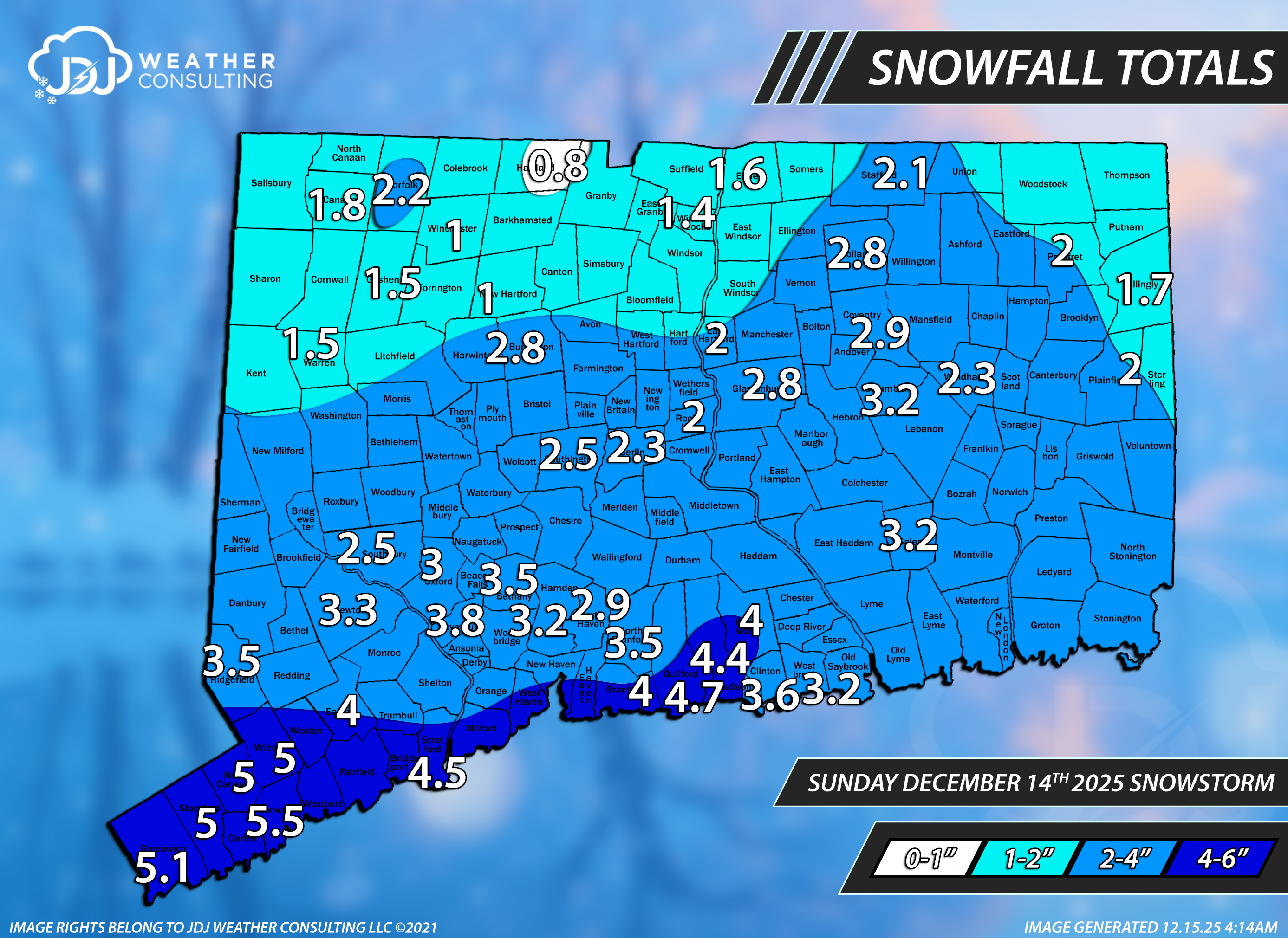
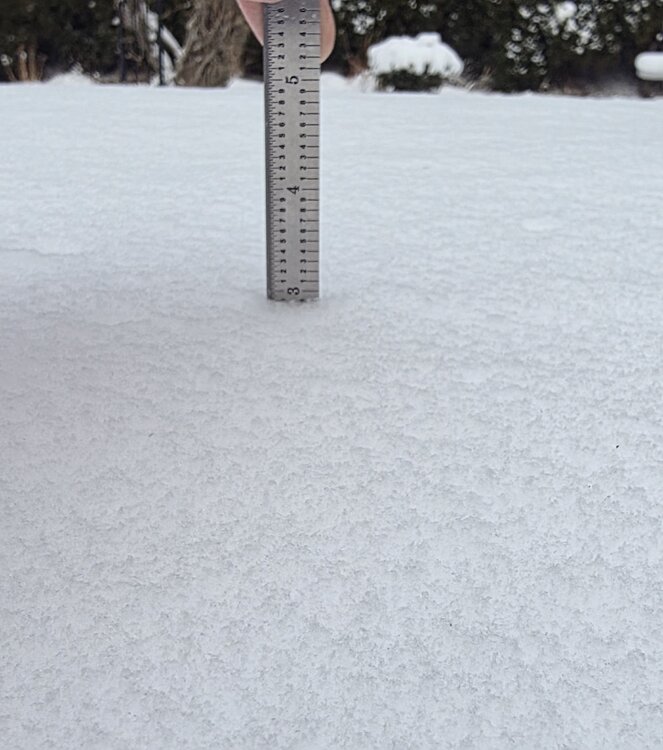
Same that's why i recorded 2.9 here because that's exactly what it was. I'd love to say 3" and call it a day. Almost everyone at my latitude broke 3" or more except probably New London county. I have a nice ruler that's divided in 1/10ths of inch for measuring snow. If I'm going to be making all these snowfall maps and determining which reports are valid and which ones are not, i should be holding myself to a high standard.

-

E PA/NJ/DE Winter 2025-26 Obs/Discussion
mattinpa replied to LVblizzard's topic in Philadelphia Region
Tonight’s GFS kept Christmas hopes alive. Maybe this season things will trend in the right direction more. -

December 2025 Short/Medium Range Forecast Thread
John1122 replied to John1122's topic in Tennessee Valley
Yes, I'm surrounded on all sides by 2500ft+ peaks. -
2025-2026 ENSO
Stormchaserchuck1 replied to 40/70 Benchmark's topic in Weather Forecasting and Discussion
Hey Larry, All of your examples 1950-1980 were -PNA January. Then you have only 7 examples after 1980.. now 7/7 is a strong point, I agree, but it might be in the field of random if you consider what ENSO is/does. A good test would be the opposite: What did January do in +ENSO after a +PNA December? What there a difference 1950-1980 and after 1980 (I haven't run the data, but will say probably not - just guessing). My map in the last post includes that, so since it rolls forward to a pretty strong N. Pacific ridge in January, I'm thinking it probably doesn't check out the other way around: (does +PNA Dec lead to -PNA Jan in +ENSO?). -
Hey Chuck, Here’s a post I made on Friday going all of the way back to 1950 that shows that for some reason (possibly randomness) the sharpest rises from a sub -1 PNA Dec to Jan have occurred since 1984-5 (CC related?): “This implies the realistic chance for a sub -1 Dec PNA. Whereas that’s bad news for those wanting E US cold in the 2nd half of Dec in the MidAtlantic/OH Valley south, it isn’t necessarily bad news for January prospects. That’s because in the vast majority of cases for -ENSO, the PNA in January rose sharply from Dec: PNA Dec/Jan for -ENSO for strongly -PNA in Dec - 1955-6: -2.1/-1.3 (rose 0.8) - 1961-2: -1.2/-0.1 (rose 1.1) - 1964-5: -1.7/-0.2 (rose 1.5) - 1971-2: -1.5/-1.4 (rose 0.1) - 1984-5: -1.6/+1.6 (rose 3.2) - 1996-7: -1.2/+0.6 (rose 1.8) - 2008-9: -1.4/+0.6 (rose 2.0) - 2010-1: -1.8/+1.3 (rose 3.1) - 2012-3: -1.0/+0.6 (rose 1.6) - 2013-4: -0.9/+1.0 (rose 1.9) - 2021-2: -2.6/+1.0 (rose 3.6) So, average PNA rise Dec to Jan for these was a whopping 1.9!
-

December 2025 regional war/obs/disco thread
H2Otown_WX replied to Torch Tiger's topic in New England
GFS is LBWSW for Xmas which seems odd for a northern stream disturbance.