All Activity
- Past hour
-
No worries whatsoever.. I know it seems locally high. The overall number of events has been impressive. Even the pennies have added up this year. Will mentioned my area? In far east Btown, is sort of banked up against the western slope, mild as it may be. But the active northern stream disturbances have suited us pretty well even if the differences might only be a quarter inch here, an inch there or whatever.
-

Outta gas and Outta Time: Early March Winter Storm finale
SomeguyfromTakomaPark replied to Ji's topic in Mid Atlantic
Perfect for this range, I’m in, looks like a decent moderate event with good temps. -

Outta gas and Outta Time: Early March Winter Storm finale
Jake Wx replied to Ji's topic in Mid Atlantic
euro ai goes north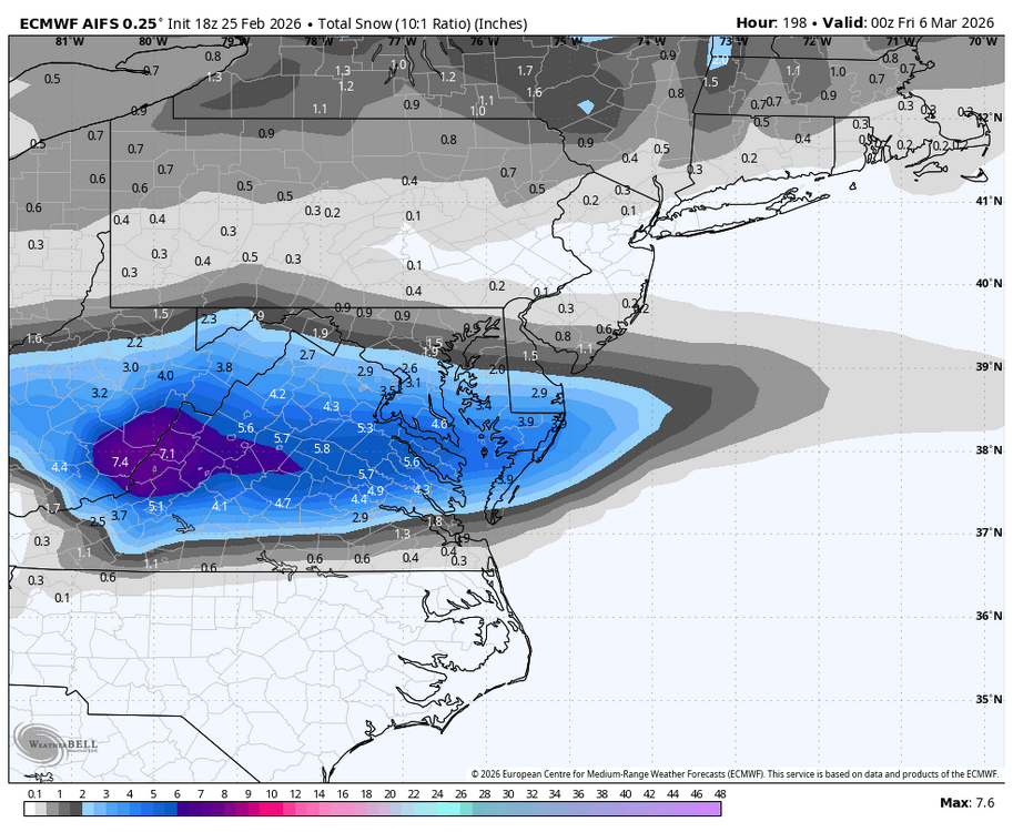
-
Off topic but i gotta go to southern Delaware and Maryland border for storm work. Any good things to see and spots to eat?
-
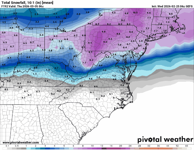
Last 3 runs of GEFS for next week
-
I’m not doubting you at all - sorry if I gave that impression
-
That’s a beast of a HP, plenty of time for some north tics. That could be a nice SWFE. Don’t they tend to tic further north than modeled in the mid-range?
-

Clipper Fires In Wednesday Feb 25 Disco/ Obs
ineedsnow replied to Damage In Tolland's topic in New England
RAP and HRRR give my area a inch or so tonight.. hopefully those squalls hold -
it might but doesn't look to last long
-

Clipper Fires In Wednesday Feb 25 Disco/ Obs
FXWX replied to Damage In Tolland's topic in New England
I don't make the decision, I just layout the options... and there was a very good one available... -
Unclear what the differences are but here's my event log fwiw. Have pics of a lot of these- 25/26 70" 12/2 6.5" moderate pac s/w, cold air in place, retreating hp, primary near BM, but warm layer pushed far inland. SN->ZR/RN with fluff overnight 12/14 2" weak ocean storm / amplification moving offshore, cold temps. Small flakes fell all morning, bit of an IVT. 6-8" jackpot NYC/NJ 12/23 1" E Canada clipper to the south and west. Minor bust, late burst for White christmas 12/26 5" light. Another clipper focused CT/NY but a nice late burst/mesoband did us good. 1/1 2" beautiful fluff with weak N stream disturbance followed by arctic fropa 1/4 .5" light snows with weak, dry clipper 1/6 .5" more light northern stream action, 2-4" inches up north 1/7 .5" sleet, wet flakes. Followed by some rain. Net loss. 1/17 5" two part clipper, light overnight to dense and sticky. Overperformer 1/18 4.5" an inch dense as moisture streamed in, then 3.5" fluffy overnight mid-level magic from ocean storm 1/21 2" fluff. Surprise northern stream waa event over deep cold air. 4" in N CT/ ORH 1/25-26 22". 2 part HECS with true arctic airmass. Swfe on roids dropped 15" settled, small dense flakes, then 7" on day 2, pure downy fluff. 2/7 4". Northern stream s/w, arctic fropa hooking into distant ocean storm. Cold, high ratio fluff. Overperformed. Crushed NEMA, SECT. 2/10 .5". Northern stream convective blobs on a weak fropa. Bad sounding w/ warmish temps, dry air. Minor bust locally. 2/20 4" heavy. snow to sleet to snow on a swfe, redeveloper. 2/23 8" dense. All time blizzard. SEMA/RI jack. Fringed a bit. Windy, dry snow. 2/25 2" fluffy. Fairly vigorous, fast moving northern stream s/w. Widespread 1-3" in SNE
-
HERE
-

Outta gas and Outta Time: Early March Winter Storm finale
stormtracker replied to Ji's topic in Mid Atlantic
Euro time! -

Outta gas and Outta Time: Early March Winter Storm finale
T. August replied to Ji's topic in Mid Atlantic
Gonna be congrats Chill by Saturday. -
2/26 - Follow-up Hopium Battlezone Storm
stormtracker replied to DDweatherman's topic in Mid Atlantic
18z Euro remains unimpressed with this one. -
Crazy, because I work in Ware and they have been pretty much similar to my backyard for every snowfall this year.
-
Outta gas and Outta Time: Early March Winter Storm finale
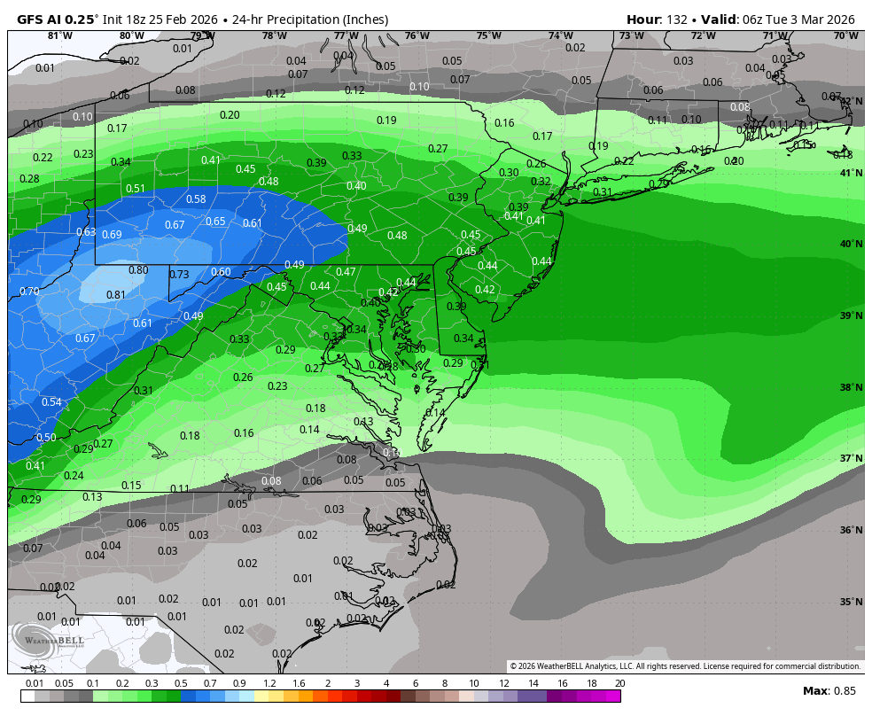
Jake Wx replied to Ji's topic in Mid Atlantic
gfs ai precip, 3-5 most likely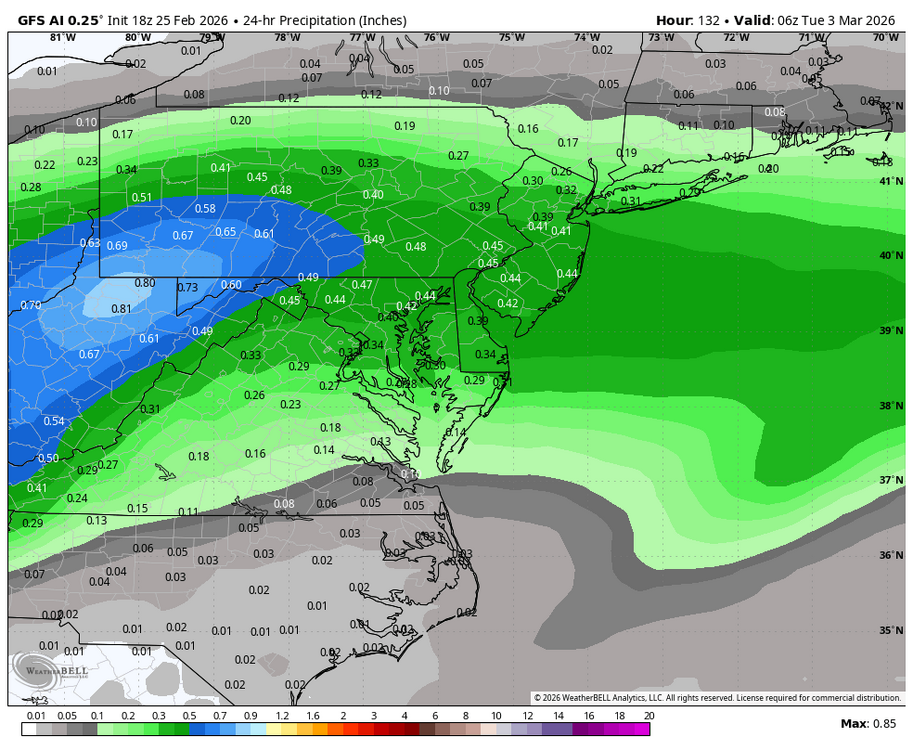
-
To dumb it down for you; there's more yellow, orange, and reds than shades of blue across the globe.
-
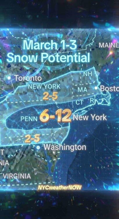
CWG is going 1-3 inches
-
70 after today!
-
Well Scooter and Tip both guaranteed it’s coming so….
-

Outta gas and Outta Time: Early March Winter Storm finale
bncho replied to Ji's topic in Mid Atlantic
there are a lot of big hits in the individual members. and i think IAD gets at least 1" from all of them.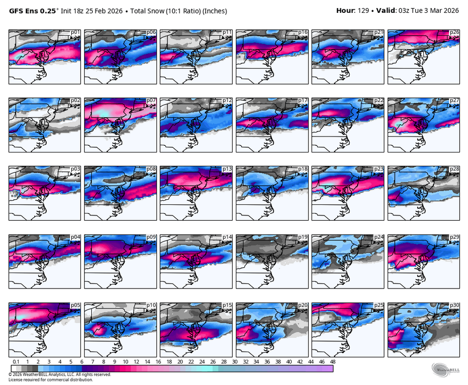
-
We’re on to the tenuous Tues/Wed period next week for next shot at wintry weather.
-
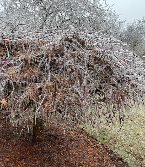
You can def get them late in the season Feb 28-Mar 1, 1995….had a lesser one but still decent on 3/2/07. And the below is from 3/23/24. Just two years ago in ORH. Most of that was midday too which is amazing that late.
-

Outta gas and Outta Time: Early March Winter Storm finale
Weather Will replied to Ji's topic in Mid Atlantic
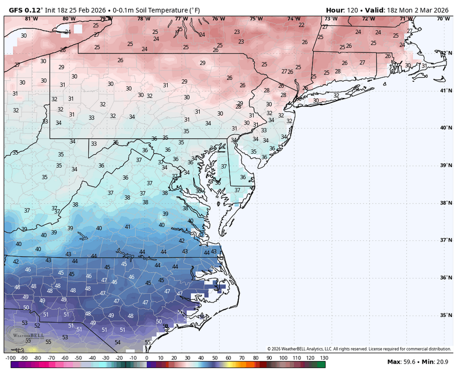
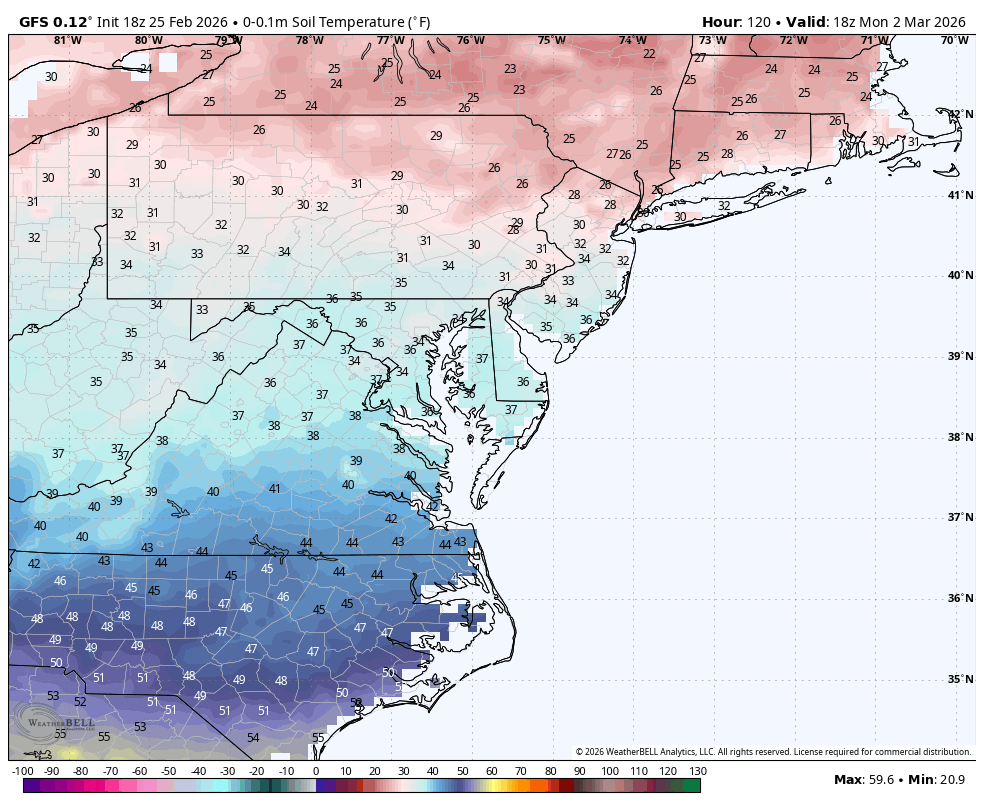
The big storm for me last weekend was a lot of white rain. Like it or not, ground temps and sun angle matter this time of year. If the snow is a light snow during the day on Monday even with temps below freezing it will melt. Soil temps never fall below freezing on Monday. Have to factor that in.