All Activity
- Past hour
-
It's such a fragile setup. Maybe the 10 pieces can assemble themselves this time to make something happen but there's been countless times since 2019 where it didn't or hit somewhere else. But there's the when I'm away rule in place like in Jan 2016.
-

Central PA Winter 25/26 Discussion and Obs
Blizzard of 93 replied to MAG5035's topic in Upstate New York/Pennsylvania
Where do I sign for the 0z GFS ? This looks like some of the runs that we had several days ago for this Sunday pm chance… Let’s see if we can reel this in…?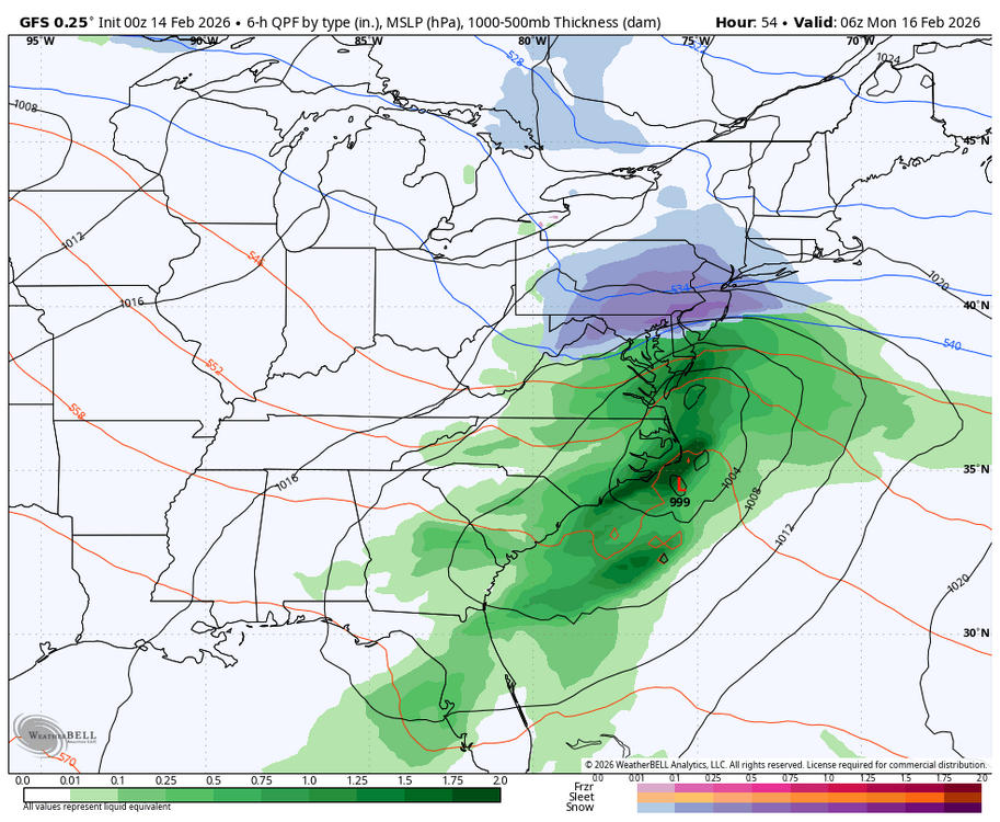

-

E PA/NJ/DE Winter 2025-26 Obs/Discussion
Kevin Reilly replied to LVblizzard's topic in Philadelphia Region
NBC 10 has spoken coating to an inch. We will update the map in the morning. Sounds right. -
I just saw it I'll talk to you in the morning
-
Another bust in the making ?
-

E PA/NJ/DE Winter 2025-26 Obs/Discussion
LVblizzard replied to LVblizzard's topic in Philadelphia Region
I’m not sure I can remember a storm threat quite like this. It’s such an unusual setup, far from what we typically see. Just crazy how such a small change at H5 in the first 12-24 hours leads to huge differences only a day later. -
He's being sarcastic.
-

Is we back? February discussion thread
RUNNAWAYICEBERG replied to mahk_webstah's topic in New England
Half a left eye still peeking, it’s creeping closer. -
What’s Tuesday?
-
Been texting you didn’t even think to go on here bc it’s mostly a nyc metro threat as of now
-
All the phasing is just giving us more cold rain here in the DC metro so let’s hope the GFS is wrong per usual
-

Is we back? February discussion thread
40/70 Benchmark replied to mahk_webstah's topic in New England
Jesus, I can't wait for Tuesday. -
I'm in Boston until Monday so it's guaranteed to hit NYC/LI when I'm away. And make for a disaster when I'm driving home. Looks here like it did at home a week ago roughly with the snowcover.
-

Central PA Winter 25/26 Discussion and Obs
MAG5035 replied to MAG5035's topic in Upstate New York/Pennsylvania
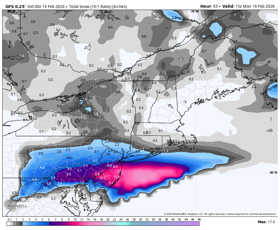
I mean I’ll gladly be wrong haha, though I didn’t completely shut the door on precip making it into southern PA. The 0z GFS is going harder than the 18z did, with a warning event in the Sus Valley and advisory all the way up through the C-PA I-80 counties. The northern feature is notably sharper and more involved than the 12z and 18z run. 0z vs 12z Models like the NAM and RGEM which hadn’t been anywhere near getting anything into PA now have lighter precip into the southern third of PA on the 0z run, although p-type is mainly rain with those models. 18z Euro, which was one of the few that got precip into PA was the same as well being similar in precip coverage to 12z but more rain. So temps are still a potential issue as they will be fairly mild Sunday. The GFS’s stronger solution would likely take care of that problem as that solution obviously has the heavier rates. You can see how a lighter event might still have issues though with the marginal surface temps. We’ll see what happens the next couple runs.
-
E PA/NJ/DE Winter 2025-26 Obs/Discussion
Kevin Reilly replied to LVblizzard's topic in Philadelphia Region
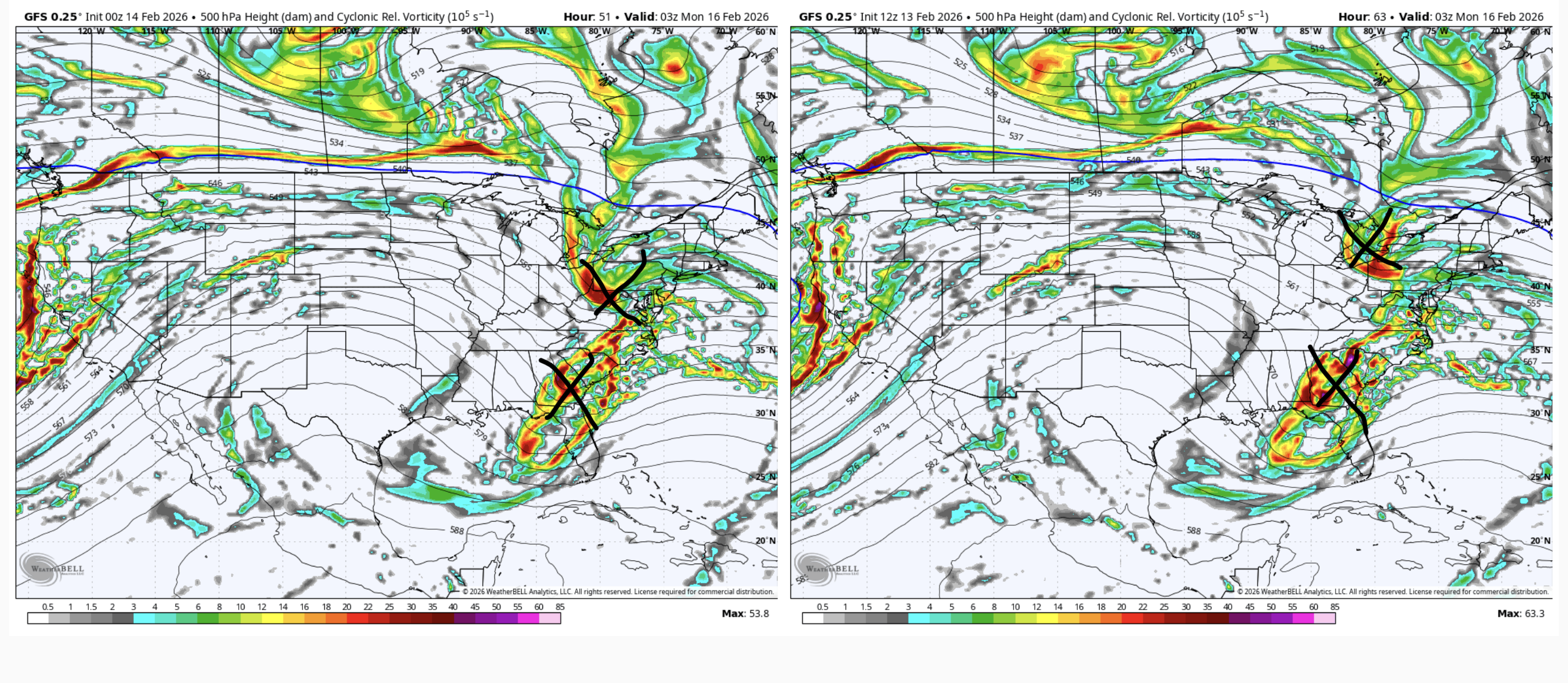
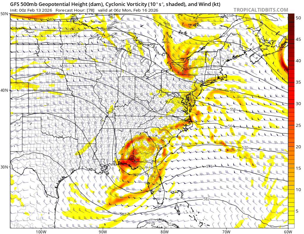
So ingredient #1 looks like a NW flow pretty evident with a low north of Quebec Canada drifting SSW. #2 Vort NNE of Winnepeg getting forced SSE. #3 low in north central New Mexico about to get the boot eastbound. #4 blocking NW flow will force storm to cut eastbound to our south then wait for a northern stream phase near Norfolk Va. You can clearly see the pieces on the water vapor map. This will be interesting to see unfold. -
It’s not even close. And the GFS is trash, worst model there is. That op run has no GEFS support. This is not going to turn into a snowstorm. This is going to be a miss/scraper, calling it now EDIT: not just no support, ZERO GEFS support
-
Look at these two friends getting together at the last minute
-
GEFS will be interesting i bet some good hits in there. I knew there was something up with this storm i never gave up fully on it, gonna want to see some more tics though and ec to come on board as well
-
Maybe maybe maybe. Ugggh if this ends up a bare bones scrape or close miss. Such a fragile setup but you'd think at this point the models are starting to have a clue.
-

E PA/NJ/DE Winter 2025-26 Obs/Discussion
Newman replied to LVblizzard's topic in Philadelphia Region
I'd love to read Mount Holly's night shift AFD on this one -
E PA/NJ/DE Winter 2025-26 Obs/Discussion
Newman replied to LVblizzard's topic in Philadelphia Region
The last 5 run trend of the GFS is wild, at some point do we see this stop trending? I still think this run is over the top and we see something more like the ICON or Euro, but it's been a long time since we've seen such significant shifts in guidance to produce a *favorable* outcome within 72 hours of an event
-

E PA/NJ/DE Winter 2025-26 Obs/Discussion
Duca892 replied to LVblizzard's topic in Philadelphia Region
Does the GFS solution have supports? -
GFS. Lol
-
Cmc is a miss but much further north than 12z
-
We have models dropping 6-10” in the city, rain, 1”, and nothing. Never seen something like this before