All Activity
- Past hour
-
. Interesting. I’m shocked at the axis of heavier stuff tho. Absolutely shocked.
-
Looks like a possible torch last week of the month based on the maps above? Even Canada is routed of cold air
-
We lost 1/2 fwiw -
-
I believe this does change the probabilities which designates the categories. For example, it looks like it will be more difficult now to get a high risk day which I think is a great idea because really if a high risk is issued...you want that to be held for days where widespread significant severe is going to happen. This may hopefully reduce more of the high risk "busts" we have seen. I am with you...I am definitely not bashing this either, just trying to understand it more. But with what you said I think makes sense and if that is the case and purpose I can understand it a bit better. I'm sure there is some literature on this, I've only read the little bit on the SPC site.
-
I suspect this is a PR method though, which is a complex human equation with lots and lots of complete dipshit oblivion reasons, that is a large spectrum of Darwinisms that range from the higher thinking ability of the mouth breathers, to general irresponsible apathy. Those hashing are not tapping our shoulders. They're trying to save those non-suspecting lives and this method may "solve" that equation above.
-
Melting was less than I expected yesterday bc of the lew dews....no filtration, just a yardstick into the snow....still over a foot.
-
Yeah, I passed by the Catskills on the way to (Saturday) and from (yesterday) Vermont. I didn't find much snow on the ground level. The snow was still there in Vermont, especially the further north I went (the furthest I went was Weston).
-
I’m not bashing it, but just trying to think about Joe the EMA guy trying to digest these products.
-
I mean is it going to hurt skill scores and just shrink the enhanced area and say in this area we could see strong tornadoes? I like that part of the new products.
-
same
-
sad but probably smart
-
This winter gets a C from me. Great start, horrendous finish resulting in below average snowfall AGAIN. Silver lining are the spring days we’ve gotten the past couple weeks
-
That's how I kind of see it. So in that tornado probability that intensity 2 area is supposed to indicate if a tornado occurs, the reasonable max intensity is EF3 and the intensity 1 area is max intensity EF2. I think though this is supposed to help local forecasters and emergency management to better communication to the public but I don't see how this helps.
-
If the intensity conditioning is just going to collocate with the overall probability then I don’t really see the point. That 2 area is basically painted right over the 10%.
-
Thinking about canceling my Utah trip in a couple weeks
-
 bncho changed their profile photo
 -

Winter 2025-26 Medium/Long Range Discussion
mimillman replied to michsnowfreak's topic in Lakes/Ohio Valley
UP winter -
We lose the furnace tomorrow but dews staying up near 40 through tomorrow night is gonna really obliterate the pack
-
So we are getting cute and hashing 90% of the area as increased tornado threat and the other 10% is supposed to be enhanced due to other reasons? Doesn’t really make sense.
-
Someone should start a thread for late Thursday into Friday. Euro and GFS hinting at a period of snow for some of the region.
-
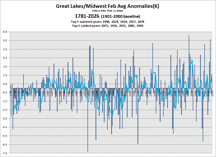
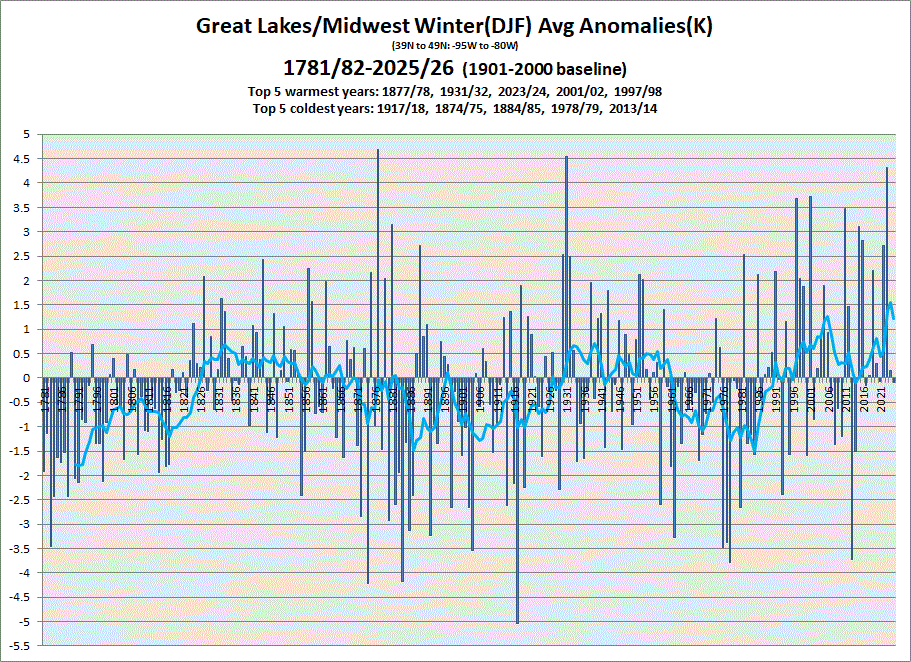
Early data in for Feb. Warmer Feb with an avg Winter in the books. 5 & 10 yr trend charts shown respectively.

-
There’s so much cold not far away in Canada. Right thru end of Morch that PV just sits up there and models show cold up there. I don’t think we are done yet. Suggest we enjoy today
-
I am still trying to gauge this new conditional intensity thing. But I am with you...seems odd the entire thing isn't filled in and what additional value does this have over the regular hatching? But I guess its to highlight what the "max intensity" may be. IDK...I feel like this is going to cause more uncertainty or even hype that isn't needed
-
lol, so ugly but also, let's go
-
Enjoy today, rest of the month looks fairly miserable.
-
I haven’t followed these new SPC products.


.thumb.png.4150b06c63a21f61052e47a612bf1818.png)