All Activity
- Past hour
-
Some broad rotation Sent from my SM-X210 using Tapatalk

-

July 2025 Discussion-OBS - seasonable summer variability
LibertyBell replied to wdrag's topic in New York City Metro
1966, 1999 and 2011 are the three most extreme Julys on this list. -
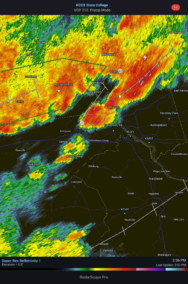
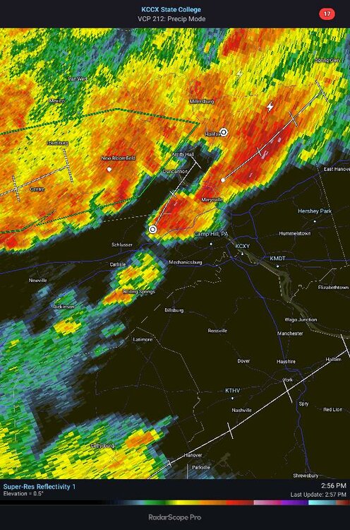
Watching this move across from my office is crazy - it is now absolutely pouring rain
-
July 2025 Discussion-OBS - seasonable summer variability
LibertyBell replied to wdrag's topic in New York City Metro
1980's historic nationwide heatwave is used as a textbook example of how lethal heat can be. https://en.wikipedia.org/wiki/1980_United_States_heat_wave The 1980 United States heat wave was a period of intense heat and drought that wreaked havoc on much of the Midwestern United States and Southern Plains throughout the summer of 1980. It was among the most destructive and deadliest natural disasters in U.S. history, claiming at least 1,700 lives.[1] Because of the massive drought, agricultural damage reached US$20 billion (equivalent to $76 billion in 2024 dollars[2]).[3] It is among the billion-dollar weather disasters listed by the National Oceanic and Atmospheric Administration. Causes [edit] The heat wave began in June when a strong high pressure ridge began to build in the central and southern United States allowing temperatures to soar to 90 °F (32 °C) almost every day from June to September. The high pressure system also acted as a cap on the atmosphere inhibiting the development of thunderstorm activity, leading to exceptionally severe drought conditions. The heat wave paused briefly when the decaying Hurricane Allen disrupted the prevailing weather pattern. Effects [edit] The drought and heat wave conditions led many Midwestern cities to experience record heat. In Kansas City, Missouri, the high temperature was below 90 °F (32 °C) only twice and soared above the century mark (100 °F or 38 °C) for 17 days straight; in Memphis, Tennessee, the temperature reached an all-time high of 108 °F (42 °C) on July 13, 1980, part of a 15-day stretch of temperatures above 100 °F (38 °C) that lasted from July 6 to 20. In Indianapolis, Indiana on July 15, the temperature reached 100 °F (38 °C) for the first time since 1954. In Dallas/Fort Worth, Texas, high temperatures exceeded 100 °F (38 °C) a total of 69 times, including a record 42 consecutive days from June 23 to August 3,[4] of which 28 days were above 105, and five days above 110. The area saw 29 days in which the previous record high temperature was either broken or tied, including its all-time high when the temperature hit 113 °F (45 °C) on three consecutive days (June 26 and 27 at DFW Airport and June 28 at Dallas Love Field). -
July 2025 Discussion-OBS - seasonable summer variability
LibertyBell replied to wdrag's topic in New York City Metro
you're losing the forest for the trees. Since you love AI so much, here is an AI briefing on that summer: AI Overview The summer of 1980 was exceptionally hot, particularly in the Southern and Southeastern United States . Key aspects of the 1980 heat wave: Duration and Intensity: The heat wave extended from June to September in some areas, driven by a strong, persistent high-pressure system. Dallas/Fort Worth experienced temperatures exceeding 100°F for almost six consecutive weeks. Wichita Falls, Texas, recorded an unprecedented temperature of 117°F. In Kansas City, Missouri, temperatures reached 100°F or more for 17 consecutive days. Dallas-Fort Worth set numerous heat records, including the all-time highest temperature of 113°F (on June 26th and 27th) and the longest streak of days with high temperatures of at least 100°F (42 days). The summer of 1980's average temperature in July for Dallas-Fort Worth was 92°F, making it the hottest month on record based on average temperature. Impact on the Population: Extreme heat was a major factor in a significant number of deaths, with estimates ranging from 1,250 to 10,000 nationwide. In Missouri alone, there were 389 heat-related deaths. In St. Louis and Kansas City, deaths from all causes increased significantly in July 1980 compared to previous years without heat waves. Elderly individuals and the urban poor were particularly vulnerable. Many lacked air conditioning, making it difficult to cope with the extreme heat. Drought Conditions: The high-pressure system inhibited thunderstorm development, leading to severe drought conditions. The Ozarks, for instance, were under extreme drought conditions. The dry conditions contributed to even higher temperatures. Economic Impact: The heat and drought severely damaged crops and livestock, leading to estimated agricultural losses of around $20 billion. Corn and soybean harvests were reduced by up to 50% in some areas. Livestock suffered greatly, with thousands of cattle deaths reported. Dairy cow milk production declined. These losses impacted the economy, causing food prices to rise and contributing to the failure of some family farms. In summary, the summer of 1980 was characterized by a widespread and prolonged heat wave that caused significant human mortality, agricultural losses, and economic damage across the United States. -
July 2025 Discussion-OBS - seasonable summer variability
LibertyBell replied to wdrag's topic in New York City Metro
You can still beat the heat by traveling outside the UHI by the way, heat is relative, it will always be cooler outside of the UHI. -
July 2025 Discussion-OBS - seasonable summer variability
LibertyBell replied to wdrag's topic in New York City Metro
The heat didn't start in June (at least not until the last week) and we're comparing sustained heat not just June but the entire summer. 1980 stands alone for July-August. -
July 2025 Discussion-OBS - seasonable summer variability
LibertyBell replied to wdrag's topic in New York City Metro
I hit 92 here at 1 PM my second heatwave so far. -
July 2025 Discussion-OBS - seasonable summer variability
LibertyBell replied to wdrag's topic in New York City Metro
It came out of the southwest and covered most of the country. Forget temperature tables and read some news sources of how lethal the summer of 1980 actually was. -
Not home, but checked in on the pet cam and it was just one crack of thunder after another. This is as electrical as I’ve seen in years.
-
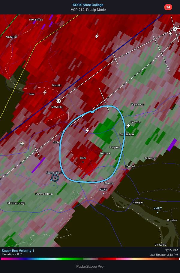
Yes - I admit I was somewhat skeptical about today but no longer...radar is angry (almost looks like it's boiling) and there's no where for it to go...
-

E PA/NJ/DE Summer 2025 Obs/Discussion
Hurricane Agnes replied to Hurricane Agnes's topic in Philadelphia Region
Had to go to a dentist appointment this afternoon and then pick up something from the pharmacy and barely made it in the door. It got dark fast! So far an up to 1.26" (total) in the bucket with > 2"/hr rates. Am under a fresh warning. Temp down to 76 with dp 73.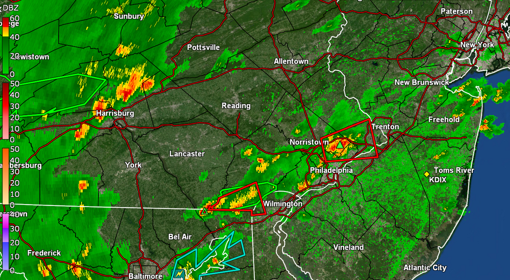
-
Maybe but right now ha
-

July 2025 Obs/Disco ... possible historic month for heat
Typhoon Tip replied to Typhoon Tip's topic in New England
I think this is my highest DP of season at 76 and it's 92. KFIT's 90/72 so the HI is up there. -
Picked up nearly an inch in 20 mins.
-
@canderson I think this may be your day Sent from my SM-X210 using Tapatalk
-
Another soaker here. Helluva pattern change the last couple months from the Great Plains pattern we were in the last 2 years.
-
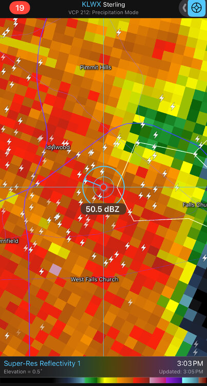
Flash Flood Warning National Weather Service Baltimore MD/Washington DC 254 PM EDT Tue Jul 1 2025 The National Weather Service in Sterling Virginia has issued a * Flash Flood Warning for... Northwestern District of Columbia... Southeastern Montgomery County in central Maryland... Western Arlington County in northern Virginia... Fairfax County in northern Virginia... The Northwestern City of Alexandria in northern Virginia... The City of Fairfax in northern Virginia... The City of Falls Church in northern Virginia... * Until 600 PM EDT. * At 254 PM EDT, Doppler radar indicated thunderstorms producing heavy rain across the warned area. Between 0.5 and 1.5 inches of rain have fallen. The expected rainfall rate is 1.5 to 2.5 inches in 1 hour. Additional rainfall amounts of 1 to 2.5 inches are possible in the warned area. Flash flooding is ongoing or expected to begin shortly.
-
Gonna get missed after it looked good for a while
-
0.85 from that first round and a fresh 75 degrees. Off to a great start!
-
3 day heat wave .
-
Storms starting to fire south of it off the outflow. It's ungodly horrible out right now with sun. I feel like rice in a steamer. Sent from my SM-X210 using Tapatalk
-
How is your annual deficit so much? I'm around 20"-21" and my deficit is only a little over 1" Sent from my SM-X210 using Tapatalk
-
1.35" was pretty much just straight down rain. Several lightening strikes and thunder
-
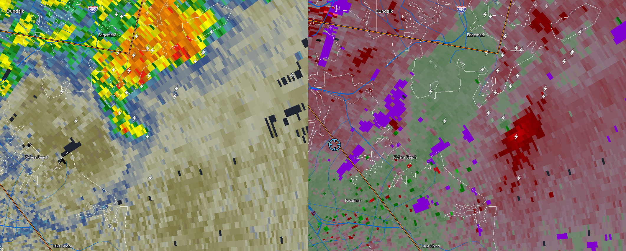
I bet this is producing a waterspout right now at the mouth of the Patapsco...

- 1,249 replies
-
- 3
-

-

-
- severe
- thunderstorms
- (and 2 more)