All Activity
- Past hour
-
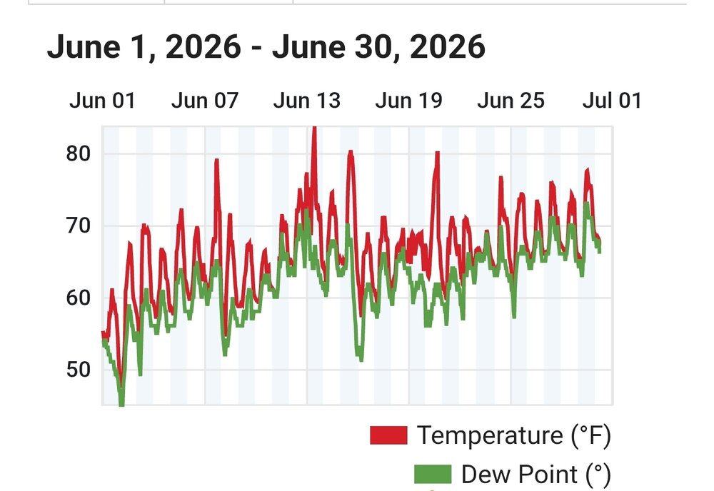
June finished here as 5th warmest and 5th driest ( 1.81" ) .
-
 Had 0.34” early last night…just enough to keep the surface wet a couple more days.
 -
love our lakes
-
 Wonder how we’ll get Steined with the MCS tonight ? Probably will hit Ginx down to the cape
 -
Yeah but you had near or over an inch Sunday
-

2026-2027 Super El Nino
bluewave replied to Stormchaserchuck1's topic in Weather Forecasting and Discussion
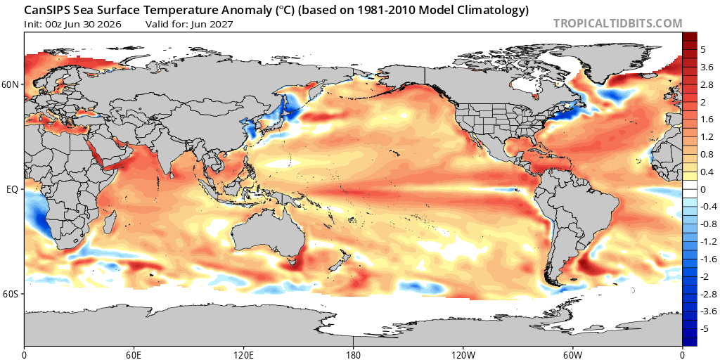
While the CanSIPS hasn’t had much skill with long range ENSO 500 mb patterns and temperatures over the CONUS, it will be interesting to see if it has some clue about the SST configuration. Notice how the much warmer the Indio-Pacific warm pool becomes following this super event than it initializes at the current time. My guess is the big baseline global temperature jump it has warms the SSTs. There is some cooling immediately near Japan. But the warm pool gets pushed a little east. Also notice how much warmer the Atlantic basin becomes. Also noticed the CFS runs doing something similar with the SSTs. The ENSO region would probably be the strangest look of all. Notice how skinny the developing La Niña cold tongue is by next June around the Galápagos Islands. It’s surrounded by continuing Nino-like waters just off equator.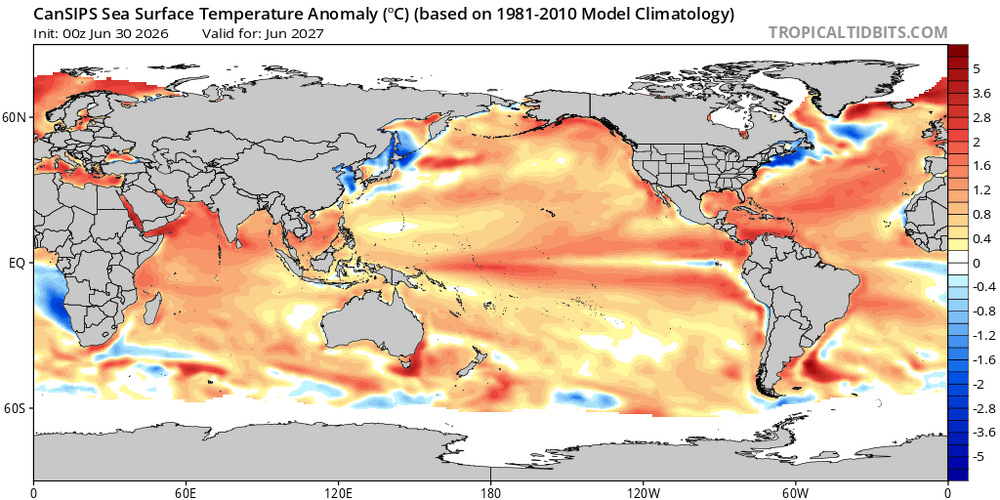
-
 I missed just to my north ( had sprinkles) last evening and nothing over night
 -

Central PA Summer 2026 Discussion/Obs Thread
pawatch replied to Voyager's topic in Upstate New York/Pennsylvania
72 for the low, DP 71 kind of mixed feelings about temperatures yesterday. Under my deck which is completely shaded 90 degrees. My other sensor which is partially in the sun was reading 102. The NWS said high was 91 which I’m not really sure that’s right. Stay hydrated theses next few days! -

Central PA Summer 2026 Discussion/Obs Thread
Mount Joy Snowman replied to Voyager's topic in Upstate New York/Pennsylvania
Low of 71. Let’s see how many Ben Franklins we can count the next few days. Stay cool everyone. -
lol. I took two of his full webbed hands up the hiney yesterday and last night. Literally missing by 1-2 miles . And then he moved them all around while he was up in there.
-

Central PA Summer 2026 Discussion/Obs Thread
mahantango#1 replied to Voyager's topic in Upstate New York/Pennsylvania
US issues emergency order for PJM Interconnection as heatwave looms By Thomson ReutersJun 30, 2026 | 5:14 PM June 30 (Reuters) – The U.S. Department of Energy on Tuesday declared an emergency across the nation’s largest power grid, citing soaring demand and supply risks as extreme heat grips the region. In an order issued under Section 202(c) of the Federal Power Act, the energy secretary said a statutory emergency exists in PJM interconnection’s region due to a combination of surging electricity demand and limited generation capacity. PJM submitted a formal request on June 29, warning of an “imminent electricity reliability emergency” driven by high temperature forecasts of around 95 degrees Fahrenheit or higher. PJM is projecting “peak loads of approximately 159,563 megawatts (MW) on July 1, 2026 and approximately 162,860 MW on July 2, 2026. These levels raise risks of supply shortfalls, threatening grid stability. The grid operator also flagged that some generation units could face constraints due to a restriction under an environmental permit or state requirement. The DOE said the order is necessary to ensure sufficient electricity supply and to protect public safety. PJM Interconnection serves a large swathe of the eastern United States, and officials warned that without intervention, extreme weather conditions could lead to system stress severe enough to impact the ability to meet electricity demand -
 Last natural AC for a bit.
 -
 Beautiful pre-heat morning here in central MA! 68F with partial cloud cover, and still comfortable humidity. The breeze still feels cool, but since it's coming from the south I expect that will change soon.
 -
Central PA Summer 2026 Discussion/Obs Thread
mahantango#1 replied to Voyager's topic in Upstate New York/Pennsylvania
- Today
-
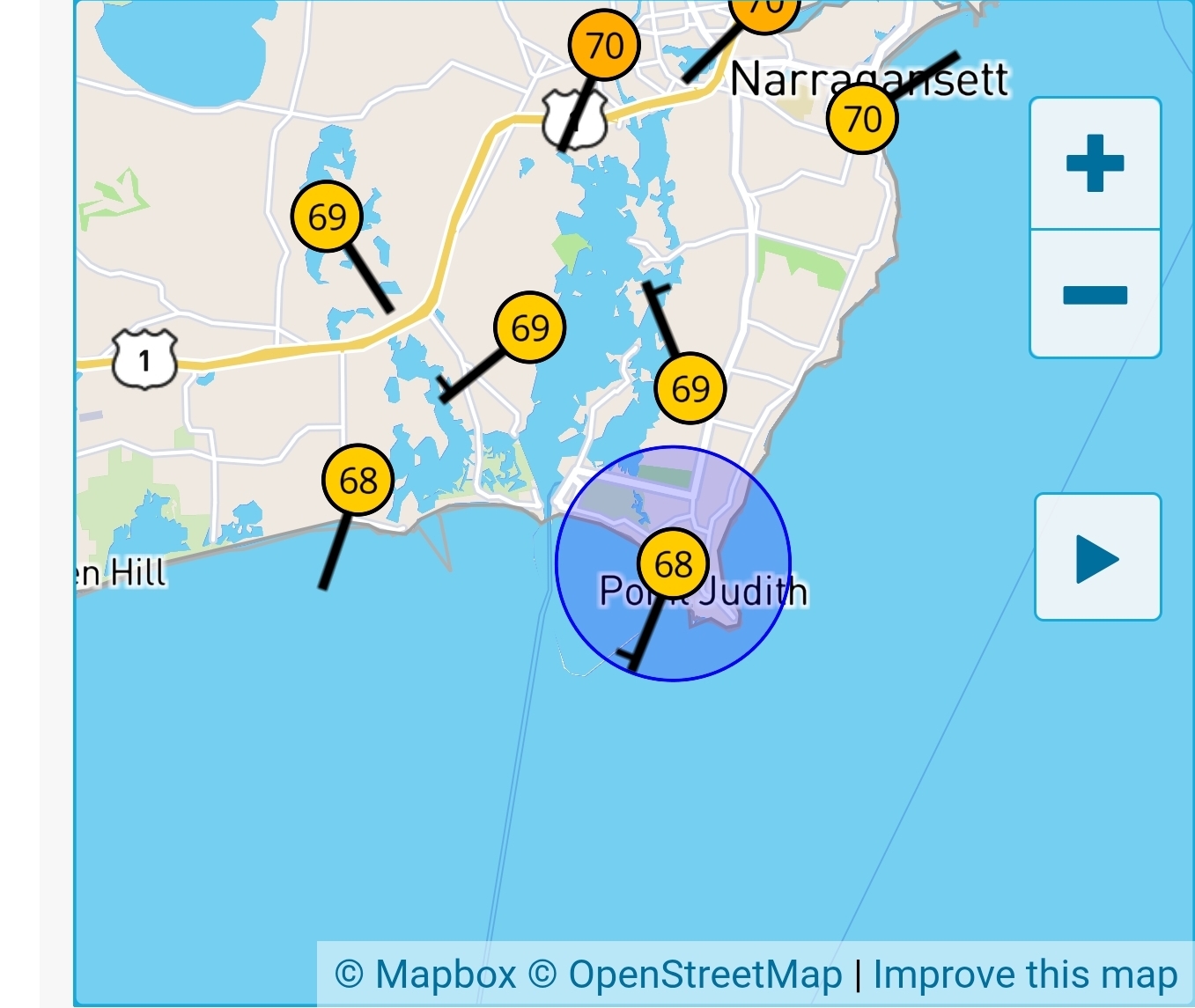
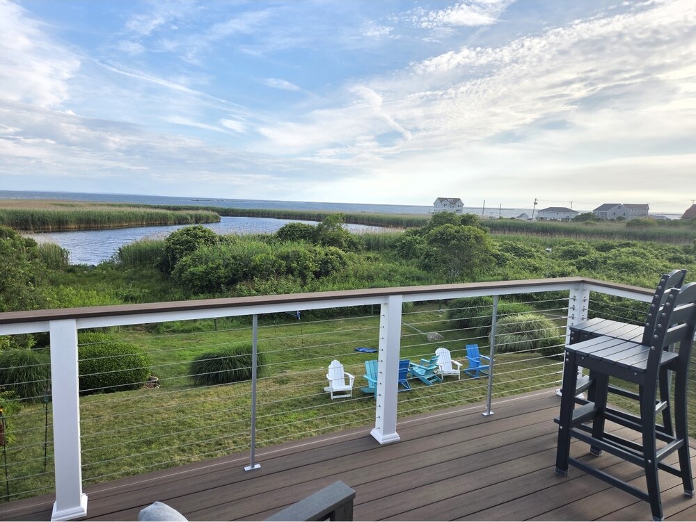
 I am heading to my sister's beach house in Narragansett out on Pt Judith today. Same thing there where only a north wind will bring in any heat. Its absolutely wild to leave there when its like 72 degrees and you get to Providence and its 102. I setup a wunderground station there a few years back. High was 72 yesterday and its only briefly touched 80 3 times this year. Probably one of the coolest locations outside of an island in New England.
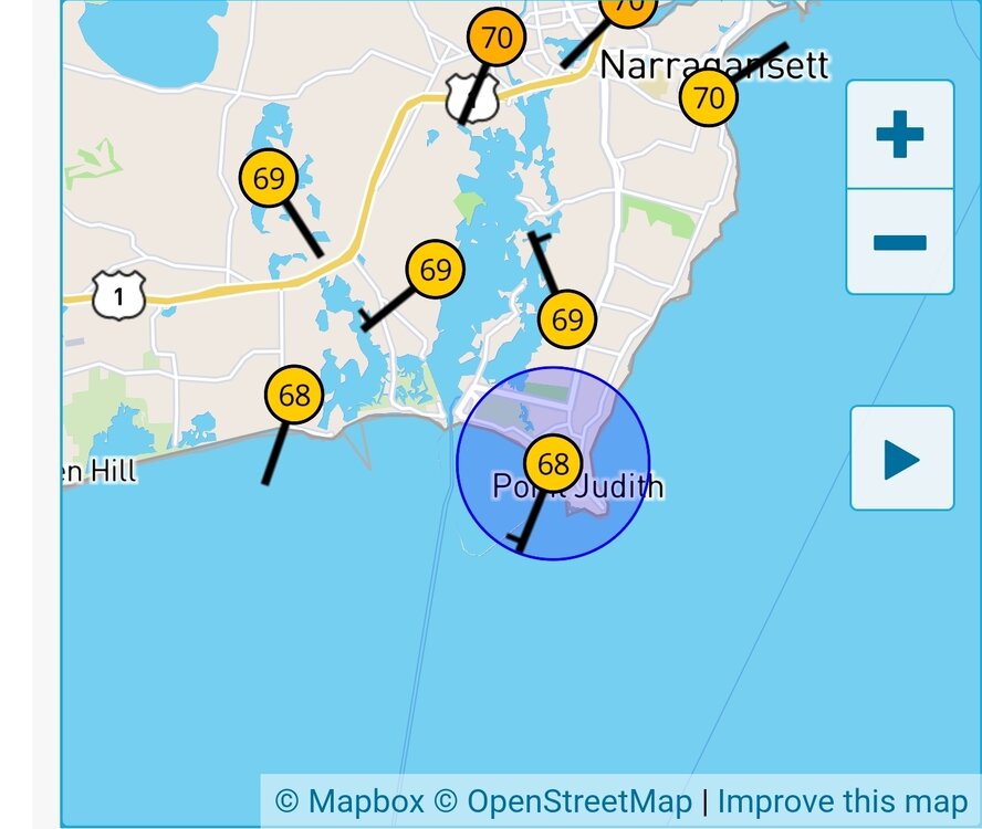
-
 Gonna roast at Winni.
 -
Central PA Summer 2026 Discussion/Obs Thread
mahantango#1 replied to Voyager's topic in Upstate New York/Pennsylvania
US National Weather Service State College PA Favorites ·Sosrdonpeth7u6mg4li24tl5c5292hh44tt4fc1cg15fic3397310gum0fu3 · Power outages do happen more often during heat waves! -
Car says 83 lol
-
I always remember Jul 95…mid level clouds until 9-10am and then it was off to the races. But yeah, clouds are collapsing pretty well on IR.
-
 0.32". Nice surprise Sent from my SM-S921U using Tapatalk
 -
Central PA Summer 2026 Discussion/Obs Thread
mahantango#1 replied to Voyager's topic in Upstate New York/Pennsylvania
Thats a good solid number, too bad others didn't make out so good. Last week I got most of my rain for the month. -
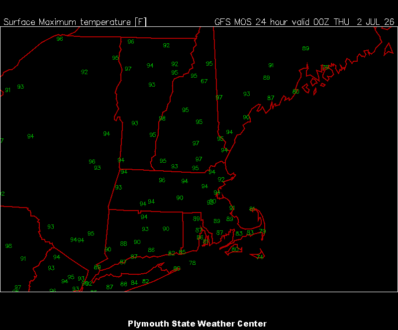
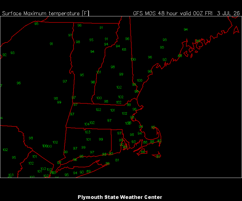
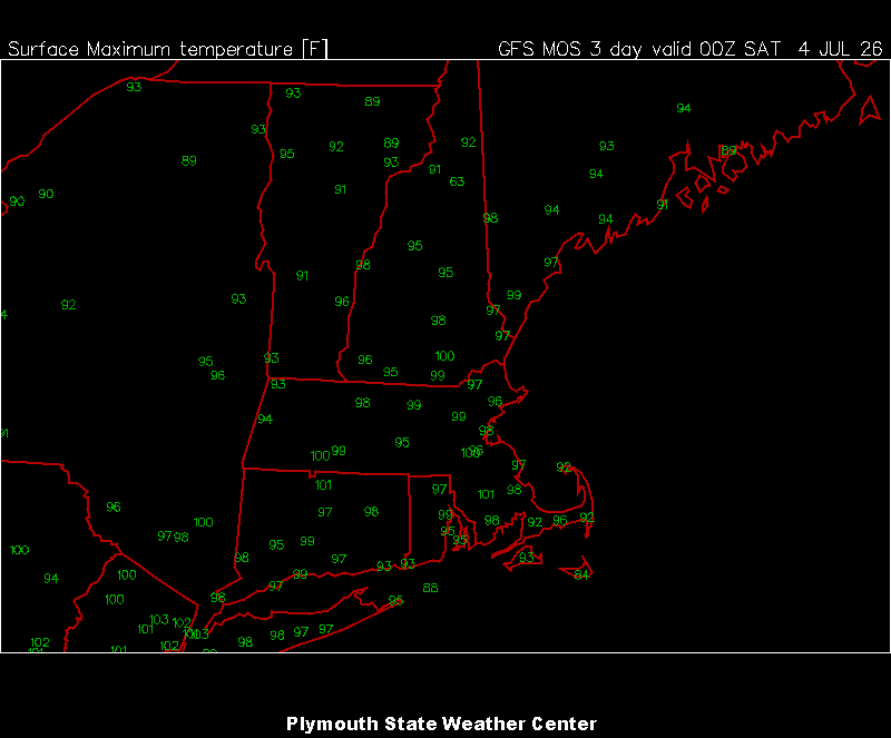
The 3 hot days are in the plym mav mos plotting window now.
-
Clouds seem to dissipating fairly quickly. Might be a bunch of cirrus through late morning.
-
94/75 for DTW yesterday. So far overnight the low is 79 at DTW and 81 at DET.
-
Nah it’s just why nobody cares about convection around here except for a few poor souls.