All Activity
- Past hour
-
Same here. Low of 31 and heavy frost.
-

Central PA Spring 2026 Discussion/Obs Thread
Itstrainingtime replied to Voyager's topic in Upstate New York/Pennsylvania
Pretty good chance I'd think. It already moved appreciably north since yesterday's outlook. -
Another penny to add to the pile- 11/11 0.1 11/30 0.1 12/02 0.2 (sleet) 12/05 3.8 12/06 1.5 12/08 0.5 12/09 5.1 01/17 0.1 01/25 4.5 (mix of snow and sleet) 01/26 2.8 (95-97% sleet) 02/04 0.3 02/07 1.0 02/23 0.2 03/13 0.1 Total 20.3
-
Going to Utah to visit the 5 national parks - leaving next weekend. Should be beautiful weather for that
-
Yep many have said that
-
I'm not a summer-seasonal guy, but I've heard it probably won't be that hot...
-
I’m sure this will be the summer where it rains every other day up there screwing up lake time while it’s stein and 94/74 here.
-
Different story up there. No argument from me.
-
You wild
-
Dry af up here. Can’t believe I’m saying this, but hopefully we get drenched this spring. This little bit of water from snow melt won’t last long.
-
The first thing to watch this summer into the fall is the PDO....I think it will finally flip positive, but can't have that remain negative, or we are going to end up with that pig ridge right over S Canada again, like 2023-2024...... -PDO/strong El Nino is awful. 1972-1973 was another one.
-
At least we know it will be active next year...welcome change. Yes, we also know temps will be a big issue, but I am done with stein seasons....so positive there.
-
out of our area but a HECS type storm for Minneapolis to Green Bay appears likely
-
Yea, well...I didn't say it was 90 degrees....but when it's too warm to snow in New England during winter, that is kind of a torch. I didn't say it the warmest winter ever...
-
Yep.
-
I can tell by the vibe and feedback from certain posters on here when I need to look.
-
(002).thumb.png.6e3d9d46bca5fe41aab7a74871dd8af8.png)
Central PA Spring 2026 Discussion/Obs Thread
ChescoWx replied to Voyager's topic in Upstate New York/Pennsylvania
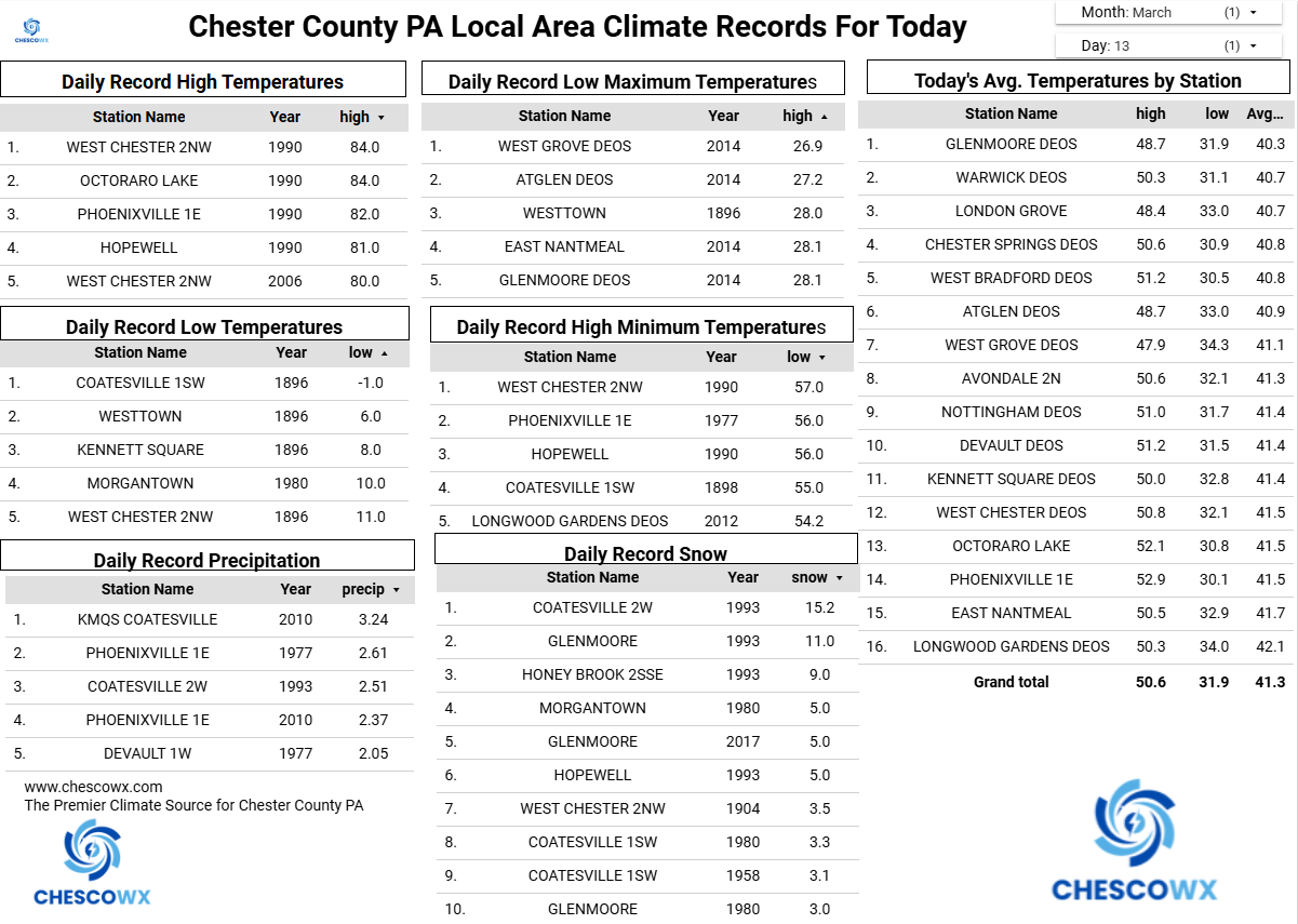
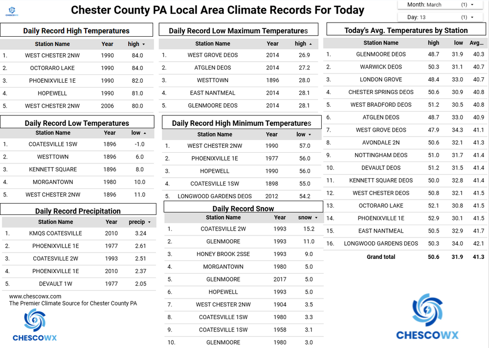
With yesterday's 0.5" of snow, we have now recorded measurable snow in each of the last 5 months from November through March. This is the 6th time that has happened in the last 23 seasons here in East Nantmeal Township. While we have recorded measurable April snow 7 times since 2004 (including last April) we have never recorded snow in 6 consecutive months. No snow in our future at least till Monday night but below normal temperatures both today and tomorrow before near normal (low 50's) highs on Sunday. We warm briefly to well above normal Monday before a strong cold front crosses the area with some potential for severe weather and another potential change to some wet snow before ending on Monday night. Unseasonably cold weather through much of next week appears likely.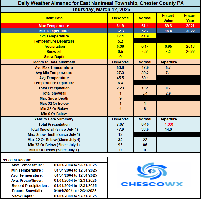
-
The 97-98 super Nino winter actually wasn’t a huge torch. It was just too warm to snow. There were a bunch of coastal storms with temps in the 30’s. The problem was it was extremely east-based, region 1+2 was over +4.0C, a secondary area of convective forcing formed there, which completely displaced the Aleutian Low over Alaska (++EPO) and the EPO floodgates were wide open all winter long with PAC air inundating Canada and the CONUS
-
E PA/NJ/DE Spring 2026 Obs/Discussion
ChescoWx replied to PhiEaglesfan712's topic in Philadelphia Region
With yesterday's 0.5" of snow, we have now recorded measurable snow in each of the last 5 months from November through March. This is the 6th time that has happened in the last 23 seasons here in East Nantmeal Township. While we have recorded measurable April snow 7 times since 2004 (including last April) we have never recorded snow in 6 consecutive months. No snow in our future at least till Monday night but below normal temperatures both today and tomorrow before near normal (low 50's) highs on Sunday. We warm briefly to well above normal Monday before a strong cold front crosses the area with some potential for severe weather and another potential change to some wet snow before ending on Monday night. Unseasonably cold weather through much of next week appears likely.
-
i always want the qpf
-
it's almost over but i just had a deja voo with with @CoastalWxill be peeking at the models until april 1st
-
I have managed to score in all of the super El Ninos, except 2015-2016 because that blizzard just missed me to the south.
-
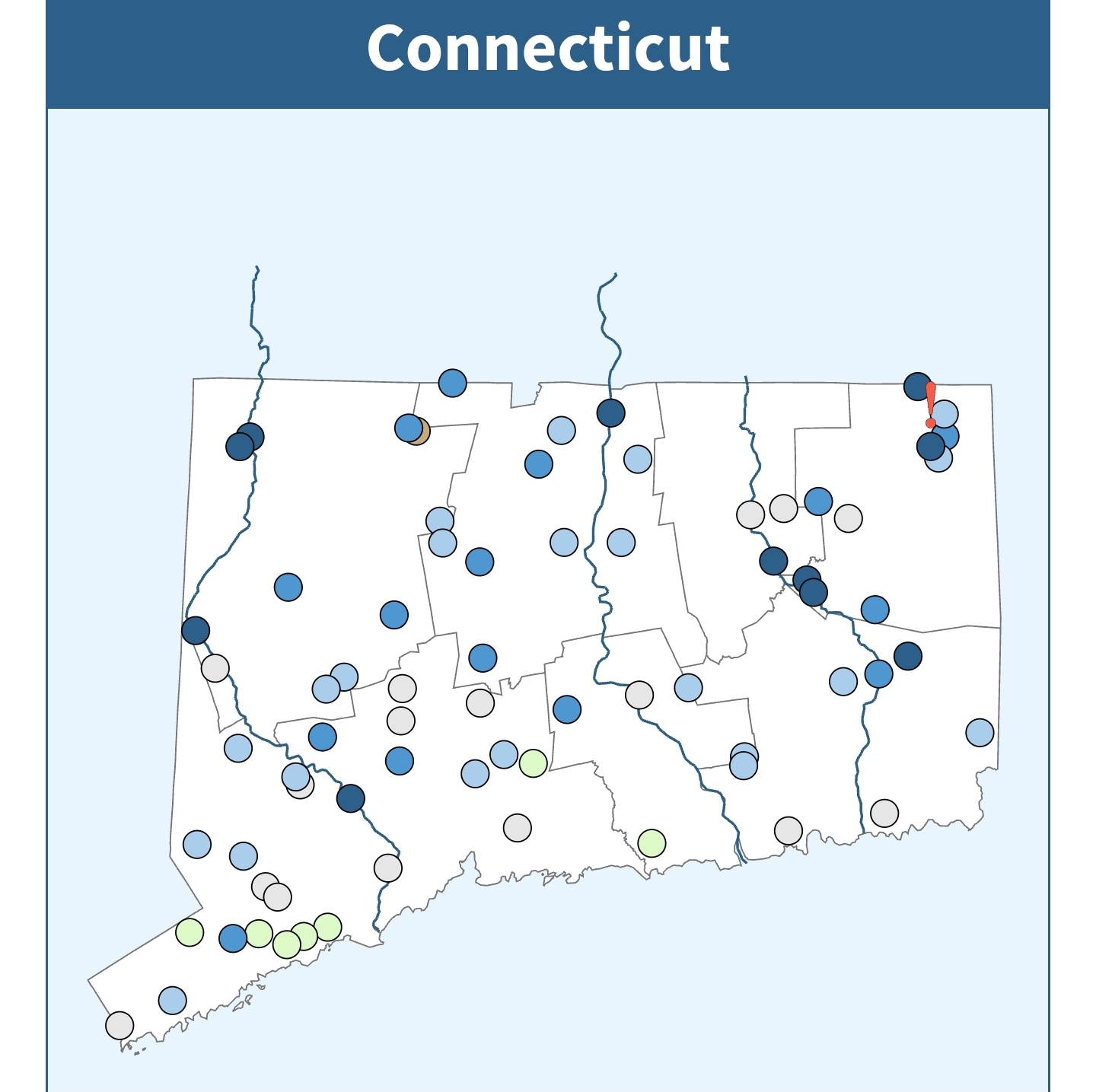
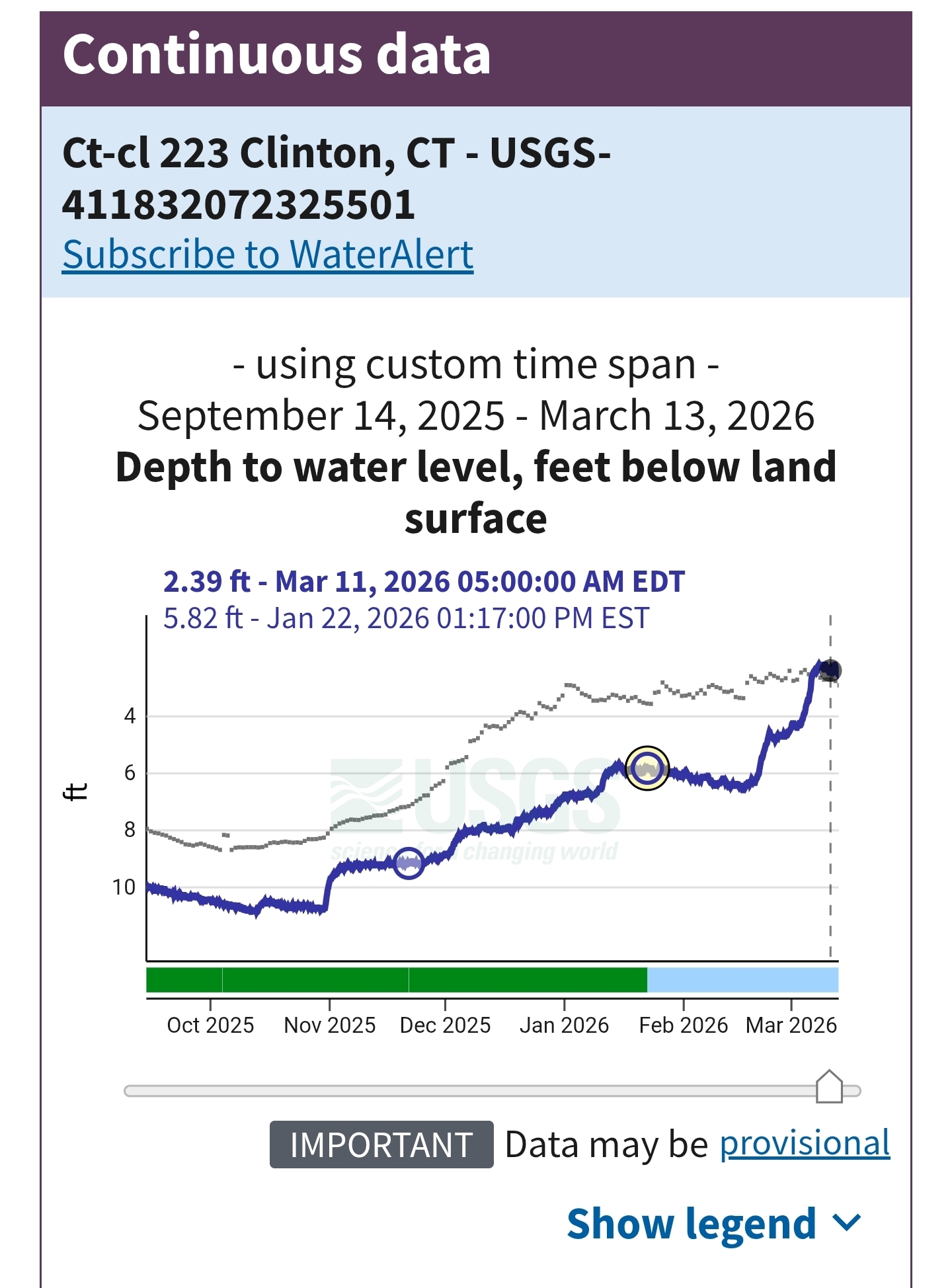
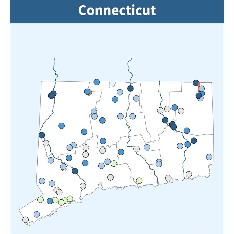
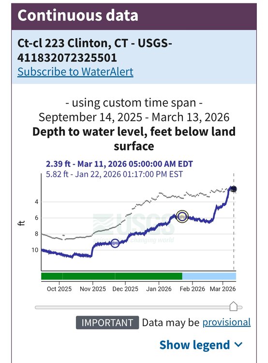
Yeah makes no sense here to be in moderate drought.. Most river and groundwater sensors are much above or extremely above in CT. Closest ground water sensor to me went from like 9ft to 2 the last year.
-
yeah it's currently rip city out there
-
I haven't viewed a model since my blog last week....says all you need to know.