All Activity
- Past hour
-

July 2025 Obs/Disco ... possible historic month for heat
DavisStraight replied to Typhoon Tip's topic in New England
Moving day today, been waiting for this day for weeks. I was hoping for a nice day but doesn't look like it in Maine. -

Central PA Summer 2025
Mount Joy Snowman replied to Voyager's topic in Upstate New York/Pennsylvania
Low of only 75. Exciting day ahead. While the humidity has certainly lived up to the hype, the temps at the official stations have come in a good bit lower than expected the last couple of days. -

July 2025 Discussion-OBS - seasonable summer variability
jm1220 replied to wdrag's topic in New York City Metro
Not many clouds here. Many of us will make a run at 90 again until it clouds up. -

E PA/NJ/DE Summer 2025 Obs/Discussion
Mikeymac5306 replied to Hurricane Agnes's topic in Philadelphia Region
Did something happen overnight with the short range models? Weather Sentry has MBY with only 1 inch total rain today and early tomorrow where on Wednesday it had over 3" Not complaining. just asking. -

July 2025 Obs/Disco ... possible historic month for heat
ineedsnow replied to Typhoon Tip's topic in New England
-
July 2025 Obs/Disco ... possible historic month for heat
ineedsnow replied to Typhoon Tip's topic in New England
it was more humid and lows bring those up.. if it was 90 every day it would be a different story,,, but when lows are making you have a top 12 July we meh -

July 2025 Obs/Disco ... possible historic month for heat
dendrite replied to Typhoon Tip's topic in New England
Nah he’s October now -
July 2025 Obs/Disco ... possible historic month for heat
ineedsnow replied to Typhoon Tip's topic in New England
number 5 is honestly much harder to achieve even if the difference isn't much.. I think September 1st he goes into winter mode? it will be nice to have him back -
July 2025 Obs/Disco ... possible historic month for heat
dendrite replied to Typhoon Tip's topic in New England
Poopooing a top 12 July but blowing a load over a min of 49° -
July 2025 Obs/Disco ... possible historic month for heat
dendrite replied to Typhoon Tip's topic in New England
Lol at nitpicking over #5 or #10. This was #9 at ORH at the new site. -

July 2025 Discussion-OBS - seasonable summer variability
donsutherland1 replied to wdrag's topic in New York City Metro
Yesterday's low temperature of 80° at JFK Airport broke the daily mark of 79°. The old record was set in 1995 and tied in 2006. It was the second such low this year, which tied the all-time record of two days set in 1999 and tied in 2016. -

July 2025 Discussion-OBS - seasonable summer variability
SACRUS replied to wdrag's topic in New York City Metro
82 / 75 clouds to the NYS border. A race to 90 will likely come up short, but may see some inland/southern areas. Storms / heavy rain in local areas Thu PM - Fri Pm 2-4 in the heaviest slowest moving storms. Cloudy / E/ENE flow keeps Friday in the 70s - similar to 6/27. Onshore barrage E/ENE flow the next 4 - 6 days jeeps it near / below normal with 90s capped. Weekend is nice overall 8/2-8/3. By the 8th flow comes around more south as the atlantic ridge builds in with a warm - hot / humid and wetter overall returning towards the 9th. Heat expanding from the west - eastward. 7/31: Hot/ Humid - storms 8/1 : Cool / cloudy (70s) Onshore 8/2 - 8/8: Onshore barrage - normal / below normal 8/9 - beyond : Warm - hot / humid wetter overall -
81/76 heat index 87, at least that is not too bad currently. Time to mow ahead of the epic rains. However, as mentioned by others, the overnight lows and overnight dewpoints are nuts !
-
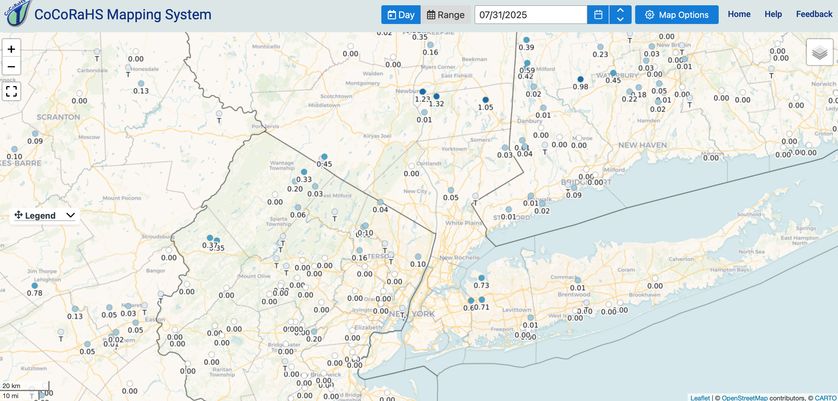
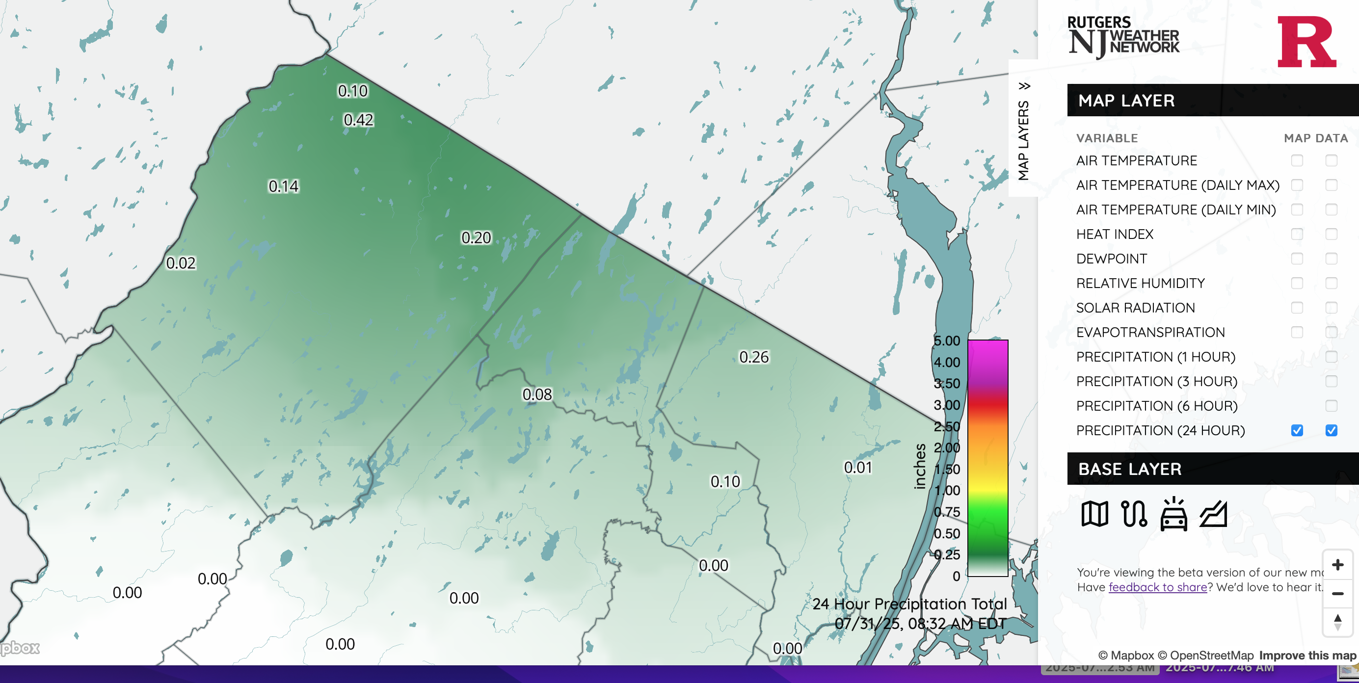
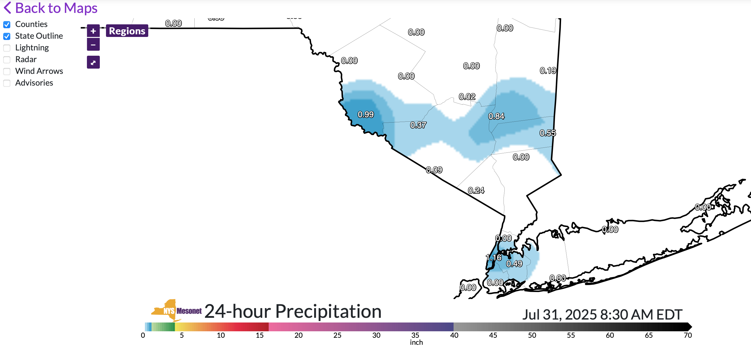
 Sampling of rainfall in narrow groups-swaths roughly 2PM yesterday- 8AM this morning. Click for clarity. Interesting 15 hours ahead. At 838AM added the NJ and NYS climate mesonet 24 hours amounts.
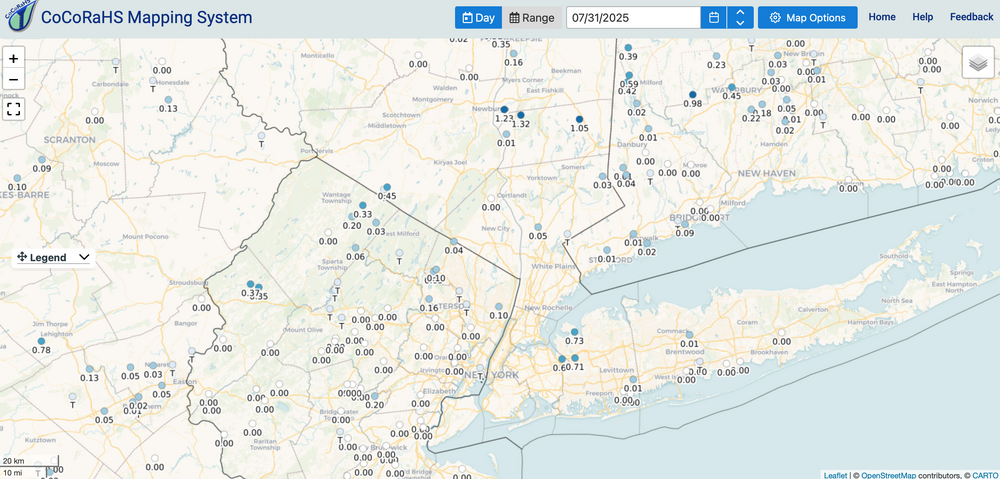


-
July 2025 Obs/Disco ... possible historic month for heat
ineedsnow replied to Typhoon Tip's topic in New England
ya but @Damage In Tolland is acting like he was right with top 5 and he wasn't -
July 2025 Obs/Disco ... possible historic month for heat
dendrite replied to Typhoon Tip's topic in New England
2024 was warmest ever -

July 2025 Obs/Disco ... possible historic month for heat
CoastalWx replied to Typhoon Tip's topic in New England
Probably kidnapped her and made her do that video. -
July 2025 Obs/Disco ... possible historic month for heat
ineedsnow replied to Typhoon Tip's topic in New England
this July was actually cooler than the last 2.. closest KORE averaging 74.02 in 2024 74.29 and 2023 74.15 for July -
July 2025 Obs/Disco ... possible historic month for heat
dendrite replied to Typhoon Tip's topic in New England
Right now it’s BOS 12, BDL 11, PVD 15, ORH 12 Maybe not top 5 but still really warm and high end -
July 2025 Obs/Disco ... possible historic month for heat
ineedsnow replied to Typhoon Tip's topic in New England
meh do we live there? also not counting lows it wouldn't be close.. dews were impressive though -

July 2025 Obs/Disco ... possible historic month for heat
SouthCoastMA replied to Typhoon Tip's topic in New England
Moregarbage was only good for having that chick with the huge jugs standing poolside. -
July 2025 Obs/Disco ... possible historic month for heat
CoastalWx replied to Typhoon Tip's topic in New England
May have to watch that line poking into Kevin’s fanny and developing NE. Probably the one to watch for any FF potential. -
With 0.62" of rain overnight, my July total thru 8am is 3.34". The July total thru 8am at DTW is 7.30". Ive never seen such a difference before.
-
July 2025 Obs/Disco ... possible historic month for heat
CoastalWx replied to Typhoon Tip's topic in New England
Sitting and spinning on it while giggling like Tom Brady down a water slide. -
lake effect sprinkles today?