All Activity
- Past hour
-
Snowed 9 PM thru about 2:30 AM, nice fluffy 2.8" on 0.23" LE, 22" at the stake. Forecast had been 1-3. Bright sun already has cleaned most of the trees.
-

Central PA Spring 2026 Discussion/Obs Thread
Itstrainingtime replied to Voyager's topic in Upstate New York/Pennsylvania
Hey, hey, hey now! I finished with the exact same numbers of you. Who woulda thunk? -
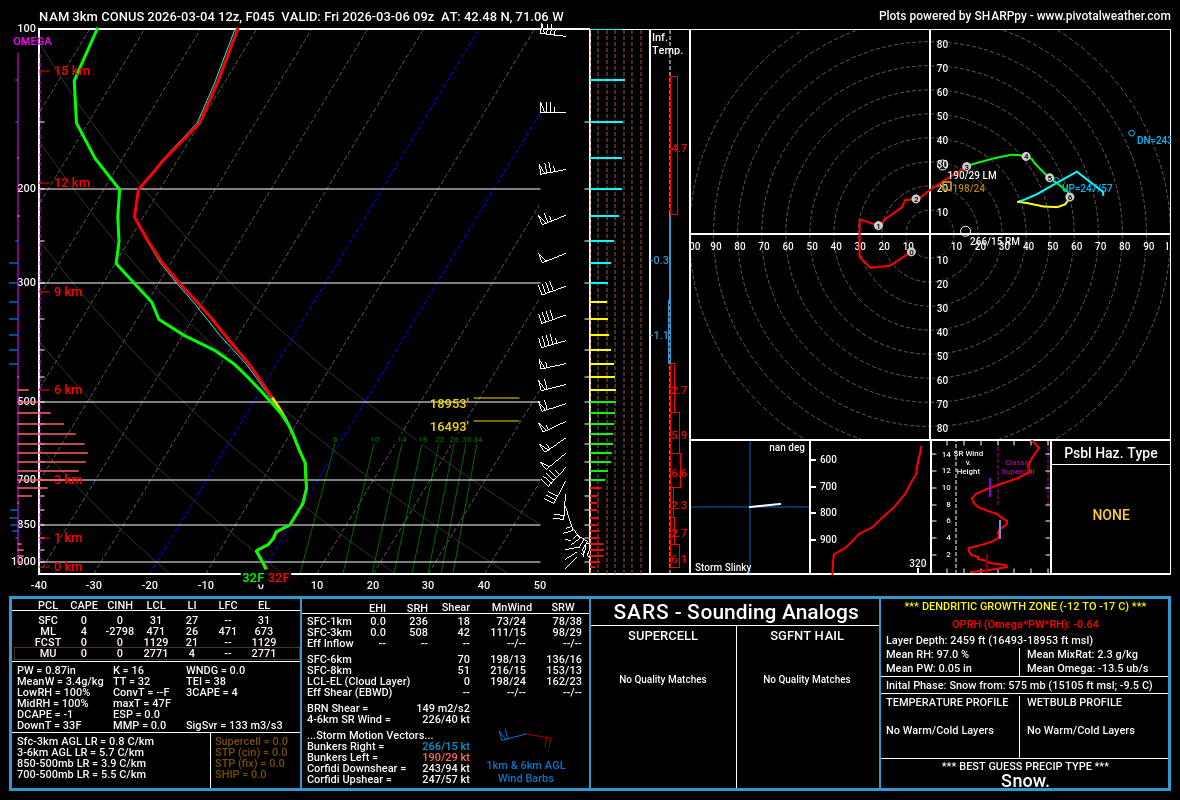
3k NAM near BOS. Mini snow bomb? Lol

-
Then there is this
.png.af0d18d9da3814fce1c319041e96881b.png)
-
For sure. Now we have snow eating fog in the valley this A.M. Pack will dissipate very quickly today between the fog and 50s
-
After the super cold swfe that's what I had for peak depths. As far as met winter goes this really has been almost wire to wire.
-
Not at 32F. Don’t think this one is for you.
-
Heavy heavy fog
-
Yup. Sweet little event from the Mountain north and high impact. Not nearly as much snow below the pike down here but it cranked for a little while and then we had a nice layer of zr on everything for at least a modest impact. Yesterday turned out pretty wintry almost statewide. The fog and zr after effects are stunning here and still a respectable pack. One would never know the sun was out not far up.
-
do Cheeze Its count?
-
Yeah, Charlie, it looks like also no UHI at those 4 GA locations that were just noted. OTOH, Phoenix (as a great example) has had a significant UHI as we’ve discussed to pile on top of CC’s effects there. So, it’s not always a red herring and it shouldn’t be ignored where it has had a lot of impact. Otherwise, it looks to others like it is purposely being hidden to exaggerate the effects of GW even if that’s not the case. I’m a disclose everything kind of person so that it doesn’t look like there’s something being hidden. That’s why I suggested Blairsville, GA, as a great choice for no UHI to cloud up the analysis. It’s also why I’m glad to see those 4 GA locations being rural.
-
Reggie will have the best handle on this tomorrow 6z
-
Do you have Scooby snacks?
-
Facebook post from some Facebook Met from like 2013. This was their winter forecast hahah
-
Let’s take the grid down
-
Nam is more sleet and cold rain south of rt 2.
-
Most of my yard is currently 16”-18”
-
Looks like over two feet otg?
-
So basically it turns into a Noreaster for Mass
.png.9b7c6172eb01fd36c19f76016651d4ab.png)
.png.794dd270540311058bd930dfcb149cf8.png)
.png.dcefa04deb21dc813228f2aea5e545c0.png)
.png.5324852c6e552e2b3d03c2e2f2b7dd66.png)
-
We’ve obviously had bigger storms this winter but yesterday was an ass kicker in terms of travel, cleanup, etc.
-
3k gone wild for some
-
More drunk emojis by Ineedsnow
-
Records: Highs: EWR: 72 (1974) NYC: 70 (1974) LGA: 69 (1946) JFK: 59 (1965) Lows: EWR: 6 (1943) NYC: 6 (1872) LGA: 7 (1943) JFK: 12 (1950) Historical: 1717: New England's "Great Snow." occurred between 2/27 and 3/7. Four storms dumped 36 inches of snow at Boston, MA and as much as 4 feet further north. Drifts up to 25 feet were reported near Dorchester, MA. Travel was virtually impossible for nearly 3 weeks. (Ref. Wilson Wx. History) 1780: Because of the very cold winter of 1779 - 1780 the port of Philadelphia was ice locked from December 21, 1779 until March 4, 1780. (p.30 Washington Weather Book 2002 by Ambrose, Henry, Weiss) 1873: The inauguration of Ulysses S. Grant remains Washington, DC’s, record cold March day. The low was 4 degrees; by noon (with sunshine) the temperature was 16 degrees (wind chills to -30 degrees). 40 mph winds made his inaugural address inaudible to most on the platform with him. (Ref. Weather Guide Calendar with Phenomenal Weather Events 2011 Accord Pub. 2010, USA) The minimum temperature for the date is 4 °F in Washington, DC. (Ref. Washington Weather Records - KDCA) 1909 - Though fair weather was forecast, President Taft was inaugurated amidst a furious storm. About ten inches of wet snow disrupted travel and communications. The storm drew much criticism against the U.S. Weather Bureau. (David Ludlum) 1951: In Riverside, CA it was 28°, their lowest temperature on record for March. (Ref. Wilson Wx. History) 1953 - Snow was reported on the island of Oahu in Hawaii. (The Weather Channel) 1960: Eastern Massachusetts' most significant March snowstorm occurred on March 4-5th, 1960. The storm produced record 24-hour snowfall totals 27.2 inches at Blue Hill Observatory, 17.7 inches at Worcester, and 16.6 inches at Boston. Winds gusted to 70 mph. 1966 - A severe blizzard raged across Minnesota and North Dakota. The blizzard lasted four days producing up to 35 inches of snow, and wind gusting to 100 mph produced snow drifts 30 to 40 feet high. Bismarck ND reported zero visibility for 11 hours. Traffic was paralyzed for three days. (2nd-5th) (The Weather Channel) 1971: A potent storm system blasted the northeastern U.S. on March 3-5th, 1971. The barometric pressure dropped to 28.36 inches at Worcester, MA, for the lowest pressure recorded at that location. 1983: Brownsville, Texas, recorded a high of 100 degrees, the earliest the city has ever hit the century mark. 1983: The maximum temperature for the date is 82 °F in Washington, DC. (Ref. Washington Weather Records - KDCA) 1987 - Rain and high winds prevailed in the northwestern U.S. A wind gust to 69 mph at Klamath Falls OR was their highest in 25 years, and winds at the Ashland Ranger Station in the Siskiyou Mountains of northern California reached 85 mph. (The National Weather Summary) (Storm Data) 1988 - Snow and freezing rain made travel hazardous in Ohio and Indiana. A six car pile-up resulted near Columbus OH, with seven injuries reported. Up to two inches of ice glazed central Indiana. Up to ten inches of snow blanketed northern Ohio. (The National Weather Summary) (Storm Data) 1989 - Thunderstorms produced severe weather in the Lower Mississippi Valley. A strong (F-3) tornado injured five persons near Brownsville MS, and killed seven cows and two hogs in one pasture. Thunderstorm winds gusted to 90 mph at Canton MS. (The National Weather Summary) (Storm Data) 1990 - A Pacific cold front working its way across the western U.S. produced heavy snow over parts of Idaho, Nevada and Utah. Up to eleven inches of snow blanketed the valleys of northwest Utah, while 12 to 25 inches fell across the mountains of northern Utah. Up to six inches of snow blanketed the valleys of east central Nevada, while more than a foot of snow was reported in the high elevations. In Idaho, 6 to 8 inches of snow was reported around Aberdeen and American Falls. (The National Weather Summary) (Storm Data) 2004 - An F0 tornado 2 miles north of Muldrow breaks a record stretch of days without a reported tornado, 292 days. 2008 - Only two days after reaching 78 degrees, St. Louis receives nearly a foot of snow in seven hours, the biggest snowstorm in 15 years.
-
What's the pack like?
-
Up to 36 in Simsbury, tons of ice to melt. We just had a massive fog bank roll in, not even quarter mile visibility right now


.thumb.png.4150b06c63a21f61052e47a612bf1818.png)


