All Activity
- Past hour
-
Yeah. Used to be higher percentage so, things does appear to have changed.
-

Major Hurricane Melissa - 892mb - 185mph at landfall
olafminesaw replied to GaWx's topic in Tropical Headquarters
https://x.com/volcaholic1/status/1983245789158642173 -

Major Hurricane Melissa - 892mb - 185mph at landfall
WxWatcher007 replied to GaWx's topic in Tropical Headquarters
Landfall expected around 2am. Not a ton of time to reorganize and intensify, but we’ll see what recon finds. -

Major Hurricane Melissa - 892mb - 185mph at landfall
GaWx replied to GaWx's topic in Tropical Headquarters
I haven’t but in the past in very strong storms, he’s gone many hours with no posts once a storm has hit. It may not be til tomorrow or later for the next post for all we know. -
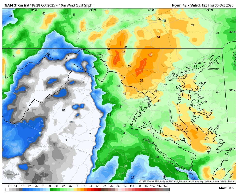
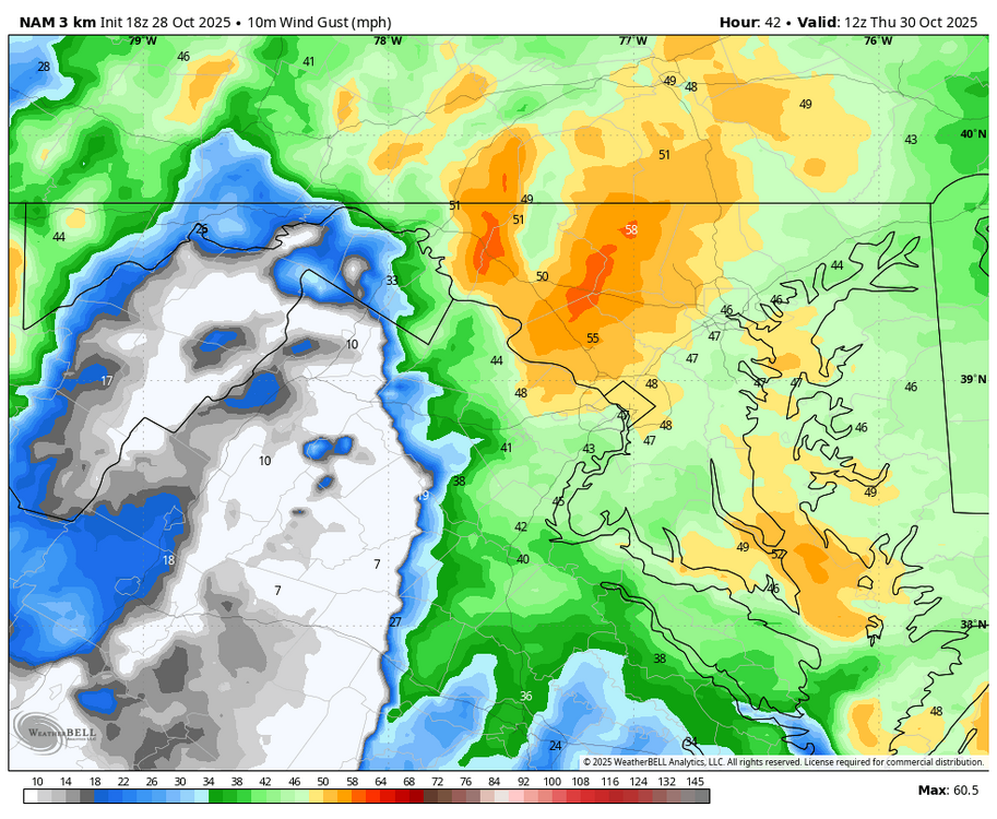
WB 18Z 3K NAM; windy and stormy Th. am on tap.
-

Major Hurricane Melissa - 892mb - 185mph at landfall
NJwx85 replied to GaWx's topic in Tropical Headquarters
Has anyone heard from Josh since LF? His last tweet was about 5 hrs ago before the worst hit. -
Major Hurricane Melissa - 892mb - 185mph at landfall
GaWx replied to GaWx's topic in Tropical Headquarters
Hurricane Melissa Discussion Number 30 NWS National Hurricane Center Miami FL AL132025 500 PM EDT Tue Oct 28 2025 The eye of Melissa made landfall in western Jamaica near 17Z with maximum sustained winds estimated at 160 kt and a central pressure near 892 mb. Since that time, the hurricane has been weakening over the mountains of western Jamaica with the eye disappearing and some warming of the convective cloud tops. Based on these changes, the initial intensity has been reduced to a highly uncertain 125 kt. NOAA and Air Force Reserve Hurricane Hunter aircraft are scheduled to investigate Melissa this evening to provide better information on how much it has weakened. It should be noted that while Melissa's landfall intensity is among the strongest ever recorded in the Atlantic basin, it will take extensive post-analysis to determine exactly where it ranks among landfalling Atlantic hurricanes. The initial motion is now 025/7. A turn toward the northeast with an increase in forward speed is expected this evening, and this should bring the center near or over southeastern Cuba late tonight or early Wednesday. After that, an even faster motion toward the northeast should bring the center through the southeastern and central Bahamas on Wednesday and near Bermuda Thursday or Thursday night. After passing Bermuda, the cyclone should continue quickly northeastward into the north Atlantic. The track guidance envelope has shifted a little to the left (north and west) through 72 h since the last advisory, and the new forecast track during this time is also shifted a little to the north and west. While the center of Melissa is now emerging over water, it will probably not re-intensify significantly before landfall in Cuba due to the limited amount of time before landfall and an upper-level wind environment that is becoming less favorable. Based on this, the intensity forecast calls for little change in strength before Melissa reaches Cuba. After leaving Cuba, Melissa should encounter increasing southwesterly vertical shear that should cause gradual weakening, although the cyclone should still be at hurricane strength when it passes near Bermuda. Based on global model guidance, Melissa is forecast to become a strong extratropical cyclone over the North Atlantic by 96 h. FORECAST POSITIONS AND MAX WINDS INIT 28/2100Z 18.5N 77.7W 125 KT 145 MPH 12H 29/0600Z 19.9N 76.7W 120 KT 140 MPH 24H 29/1800Z 22.2N 75.3W 100 KT 115 MPH 36H 30/0600Z 25.0N 73.2W 95 KT 110 MPH 48H 30/1800Z 28.9N 70.0W 90 KT 105 MPH 60H 31/0600Z 33.8N 64.8W 85 KT 100 MPH 72H 31/1800Z 39.0N 58.3W 70 KT 80 MPH 96H 01/1800Z 48.4N 42.2W 50 KT 60 MPH...POST-TROP/EXTRATROP 120H 02/1800Z 54.8N 25.1W 40 KT 45 MPH...POST-TROP/EXTRATROP $$ Forecaster Beven -

Major Hurricane Melissa - 892mb - 185mph at landfall
gallopinggertie replied to GaWx's topic in Tropical Headquarters
The good news for Cuba is the forecast has shifted west, the NHC track now shows a landfall about 55 miles west of Santiago de Cuba, on a stretch of coast where hardly anyone lives. -
Major Hurricane Melissa - 892mb - 185mph at landfall
NJwx85 replied to GaWx's topic in Tropical Headquarters
Nova Scotia better watch out. Lots of guidance tracks this very close to Atlantic Canada in about 96hrs. This after hits on Cuba, the Bahamas and Bermuda likely. -
Major Hurricane Melissa - 892mb - 185mph at landfall
GaWx replied to GaWx's topic in Tropical Headquarters
BULLETIN Hurricane Melissa Advisory Number 30 NWS National Hurricane Center Miami FL AL132025 500 PM EDT Tue Oct 28 2025 ...CENTER OF MELISSA EMERGING FROM THE NORTHERN COAST OF WESTERN JAMAICA... ...DAMAGING WINDS. CATASTROPHIC FLASH FLOODING, AND LIFE-THREATENING STORM SURGE CONTINUES IN JAMAICA... SUMMARY OF 500 PM EDT...2100 UTC...INFORMATION ---------------------------------------------- LOCATION...18.5N 77.7W ABOUT 15 MI...20 KM E OF MONTEGO BAY JAMAICA ABOUT 200 MI...325 KM SW OF GUANTANAMO CUBA MAXIMUM SUSTAINED WINDS...145 MPH...230 KM/H PRESENT MOVEMENT...NNE OR 25 DEGREES AT 8 MPH...13 KM/H MINIMUM CENTRAL PRESSURE...921 MB...27.20 INCHES -
Yes Will, the 18z NBM increased my QP from 1.50" to 1.75" as I expected from 2 hrs. ago. The NBM is easy to predict........................
-

Major Hurricane Melissa - 892mb - 185mph at landfall
clskinsfan replied to GaWx's topic in Tropical Headquarters
https://x.com/yungsenshi/status/1983240559067013254 -

Spooky Season (October Disco Thread)
powderfreak replied to Prismshine Productions's topic in New England
Yup. Looking your way… MWN on horizon.
-
.thumb.jpeg.f5c6ba9d911ec96b3b124f8606aee58e.jpeg)
Major Hurricane Melissa - 892mb - 185mph at landfall
TJW014 replied to GaWx's topic in Tropical Headquarters
Better electric infrastructure than my town. Power goes out here in a 25 mph breeze -
Major Hurricane Melissa - 892mb - 185mph at landfall
WxWatcher007 replied to GaWx's topic in Tropical Headquarters
The next recon flight is in the air and will be able to sample Melissa a bit after it emerges from land. -
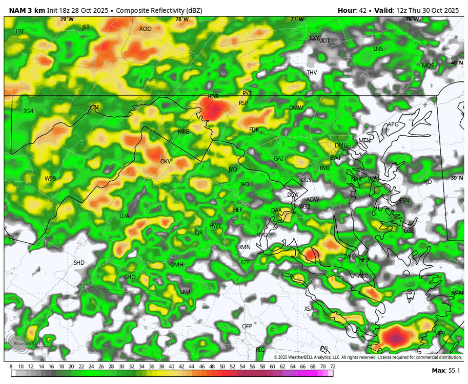
 Probably my last til 8A tomorrow an then I'll be off line all day tomorrow roughly 830A-8P. NO changes to the thread headline... I like it very much as is. Mesoscale modeling will show bands of 3" and some spots 1/2-1". 18z HRRR and NAM have no dry slot til after 03z/31. 18z WPC continues with their 1-1.75" isohyets for virtually the entire subforum. They must have gone with the heavier 12z EPS/EPSAI ...maybe Deepmind? though I dont have access to Deep Mind. 12z CMCE and GEFS were less than WPC so there is always that possibility. The 12z ensembles were heavier than many of op runs. Lets see how it plays. I have not read any discussions today from NWS.. so there may be some reasoning I missed. PHI has started their advisory for coastal flooding NJ coast south of Monmouth. It's only a matter of time I think that the advisory expands northward, but FOLLOW NWS. I suspect a wind advisory issues for coastal sections tomorrow morning (6 hr window in the aft or eve depending on location) and reserving the back side. That prepares folks for some delays etc. Friday wind advisory possibility NJ/LI reserves for a later issuance. HSLC thunder and squally gust possible late Thu. There is going to be significant impact for a few hours Thursday, especially afternoon-eve. One final addition at 450P. NAM 5H 12 hr HFC cyclicly at least last 3 cycles near 200M in e PA around 06z/31. Should become a little unstable for a few hours ahead of it.
 -
Major Hurricane Melissa - 892mb - 185mph at landfall
WxWatcher007 replied to GaWx's topic in Tropical Headquarters
The center is starting to or will imminently emerge back over the Caribbean. Clearly, the trek over Jamaica has disrupted the structure. I'll note however that there is still very strong outflow evident in all quadrants, deep convection surrounding the center, and relatively low wind shear. The radar that @klw is useful to an extent in showing the degradation of the inner core but given the factors I just mentioned we should watch what happens in the coming hours as this fully emerges and has time to potentially reorganize. -

Major Hurricane Melissa - 892mb - 185mph at landfall
smokeybandit replied to GaWx's topic in Tropical Headquarters
I'm impressed how many of the Jamaica webcams are still online. -

Major Hurricane Melissa - 892mb - 185mph at landfall
tamarack replied to GaWx's topic in Tropical Headquarters
True. The far longer lead time allows for 'cane chasers to find a safer spot. Josh picked the most solid-looking building at the north end of Great Abaco Island for Dorian and caught some amazing video of the front end. That "solid" building was badly damaged, and he (and others in that building) relocated during the eye. Tornado chasers are usually in vehicles and have minutes, or even seconds, to choose their spots. -
Working in the yard the last few days and the top soil is dust. Bone dry. October rainfall to date at my location is 1.56". That is FAR better than last October when the entire month had just a Trace. Still need rain badly. Think reasonable expectation for my area is 1" from the coming event based on current guidance. Anything more will be a gift and anything less will be a disappointment.
-
 Working in the yard the last few days and the top soil is dust. Bone dry. October rainfall to date at my location is 1.56". That is FAR better than last October when the entire month had just a Trace. Still need rain badly. Think reasonable expectation for my area is 1" from the coming event based on current guidance. Anything more will be a gift and anything less will be a disappointment.
- 20 replies
-
- 1
-

-
- heavy rain
- damaging wind? squalls?
- (and 2 more)
-

Major Hurricane Melissa - 892mb - 185mph at landfall
str8liner replied to GaWx's topic in Tropical Headquarters
She is not a big fan of vacuum cleaning Jamaica it appears. Much happier vacuuming the ocean. -

Major Hurricane Melissa - 892mb - 185mph at landfall
WolfStock1 replied to GaWx's topic in Tropical Headquarters
Well - Mitch made landfall with 80 mph winds; Melissa of course was over double that. Orders of magnitude more damage from 180 mph wind. -

Major Hurricane Melissa - 892mb - 185mph at landfall
Normandy Ho replied to GaWx's topic in Tropical Headquarters
This. The main difference between them is size -

Major Hurricane Melissa - 892mb - 185mph at landfall
CAPE replied to GaWx's topic in Tropical Headquarters
You're on the right track, I think. Both tornados and hurricanes exhibit vorticity and wind(a vector quantity). The big difference is the scale, but at a given point the wind velocity is what it is in both cases. Now consider the vorticity and lift. Much of the extreme damage we see in a tornado results from the(straight line) wind at a point PLUS the very strong localized lift within the more localized vorticity- an intense localized suction vortex. This produces the forces we see in videos that dramatically rips off roofs and uproots trees while lifting the debris rapidly upwards. Tornados are more intense, or 'violent' in a much more localized area.