All Activity
- Past hour
-
 82 / 65 here.
 -
You know what was cool? Being completely missed again yesterday. Crunchy grass is good, right? 0.90" over the last 30 days IMBY
-
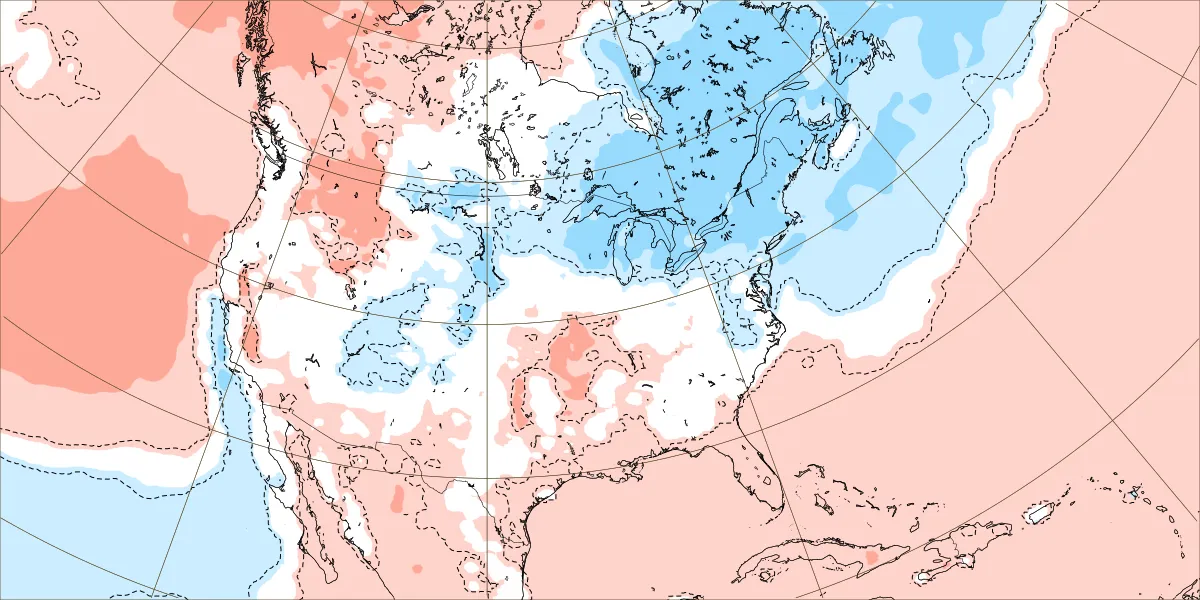
CON is +4.8F on the highs and -1.1F on the mins. Yore heat
-
Well..at least we have 6 months of fall incoming.
-
The difference between cold-neutral and weak La Niña is negligible. Same atmospheric response. The atmosphere isn’t going to say “I’m going to behave completely different because there’s a technical classification as ‘cold-neutral’ as opposed to ‘weak La Niña’. The classification difference between the two is one degree C
-
Heh, how soothing would that be if you were homeless? Luckily, CC will ultimately prevent 4:30 PM heavy snow when it also triggers civilization collapse we won't likely have to suffer the former state of affairs. Not to spark off a moron's subjectivel insufferable debate ... but, as I get older, I'm losing connection to even that nostalgia. I'd just prefer it stayed mild enough all winter to continue engaging in outer low grade athletic activities. Like bike rides. Golf, both disk and stick varieties. Going for runs. Tennis..etc. I'm probably destined to a warmer climate during retirement, provided the shit below doesn't get in the way. Just a few hurdles to overcome ... If I were a billionaire ...I'd build an extra-double top secret compound in the wilderness somewhere, replete with all three: water, wind and solar power generation options. AC/DC converters and state of the art battery capacity is utterly off power-grid. This compound's 15,000 acres would be surrounded by a 30' wall with guard towers, the top perimeter of which has highly sophisticate movement detection and entity identification ...annnnd with precision laser ammo (no bullets) it'd sound like a electrical fly zapper whenever some red neck in tattered rags with fractured words that read something like, 'makin 'merica great aghin' attempts to incur upon the edifice of the wall... Oh, throw bombs over the wall? well...little does anyone know, there's a extra-double, top secret black project in QM that has developed Quantum Interference force field technology. When turned on, it creates a transparent sphere of uncertainty principle; such that anything or object of reality that attempts to move through it, can't, because said objects quantum state ceases to exist. This is precisely calibrated to be on the inner 'last defense' side of the wall... you know, give 'em a chance to give up. To mention, sanitizing/recycling above ground. Need to have an under ground self environmentally sustained/contained storage facility. 20 year's-worth of stored various freeze dried and/or non-BPA canned food stocks for if/when hunting and growing seasons fail ... Ranging over to the typical accoutrement of needed sundries for health. The inside of the living complex has pool, rec room... movie theater, and standard living quarters. Yeah I see myself headed that way ...
-

2025 Atlantic Hurricane Season
BarryStantonGBP replied to BarryStantonGBP's topic in Tropical Headquarters
Won’t be surprised if Erin takes the role of the cleaning lady cleaning out school dinner crumbs on the table (dry air) before more kids come to play and they’d have an easier time -
as my wife says...safe trip!
-

2025 Atlantic Hurricane Season
Kevin Reilly replied to BarryStantonGBP's topic in Tropical Headquarters
Yea so Erin is kind of the lead running back to scour out the remaining Saharan Dust and dry air opening the door to other features as we move towards the peak of hurricane season. -
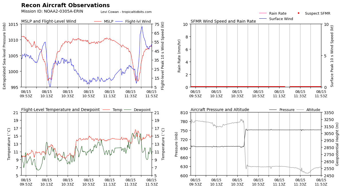
KERMIT SAYS CLOSED EYE LADS Peak Flight-Level Winds: 75kt at 12:07z Peak SFMR: 65kt at 12:07z oval eye 19x27 nm wide 17.84N 54.77W 2C Delta a 10K-ft
-

Central PA Summer 2025
Mount Joy Snowman replied to Voyager's topic in Upstate New York/Pennsylvania
Low of 70 with .45" of rain. Any storms that pop later today should come from the southeast. Love me some "opposite" storms. The only guarantee is that Lancaster will be in the bullseye ha. -
Not that late summer/early fall cold shots are always indicative of an incoming cold winter, I'd bet my retirement that most warm winters lack them. So decreasing the chance of a warm winter is always a step in the right direction at this point of the year imho.
-
Hope so. Summer's too short.
-
Gonna make a bold prediction the names Erin, Gabrielle, Humberto, Karen and Lorenzo will be 2025’s majors
-
2025 Atlantic Hurricane Season
BarryStantonGBP replied to BarryStantonGBP's topic in Tropical Headquarters
Gonna make a bold prediction the names Erin, Gabrielle, Humberto, Karen and Lorenzo will be 2025’s majors -
I haven’t weighed in on the great debate and I love summer, but the dog days are over and the step down is here. Still summer…but you know what’s coming next.
-
If right, it'll still go down as an Enso neutral winter since they don't include MEI or RONI...not that they shouldn't start considering them.
-
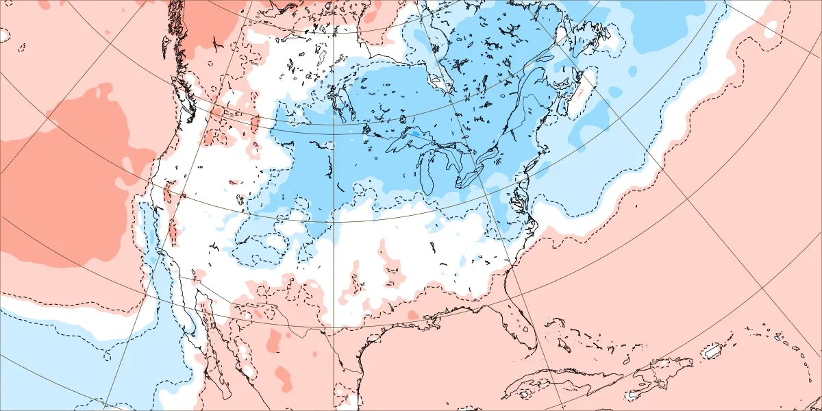
Aug through two weeks (8/14) EWR: -1.2 NYC: -1.2 LGA: -1.9 JFK: -1.9
-
Yeah MKX is really highlighting the potential for multiple rounds of rainfall pretty much every night from tonight through Tuesday next week, depending on where the mesoscale boundaries and such line up. This could get interesting fast around here, as thanks to last weeks rain we can't really tank a couple inches of rain again. And anything E of the Rock would be a huge concern given all the flooding in Milwaukee and fact that the rivers have mostly just fallen out of flood stage. These types of events with a stationary boundary sitting across the state have really hurt in the past (2018,2007). Hopefully it will not be to that level at all, but considering what happened lsat week I'm not all that confident to say the least.
-
Records: Highs: EWR: 99 (1988) NYC: 97 (1988) LGA: 97 (1985) JFK: 98 (1988) Lows: EWR: 54 (1964) NYC: 54 (1964) LGA: 59 (1964) JFK: 57 (1964) Historical: 1787 - Tornadoes were reported in Connecticut, Rhode Island, Massachusetts, and New Hampshire. Wethersfield CT was hard hit by the tornado outbreak. (David Ludlum) 1886: This tornado was estimated to be an F3 and moved northeast from 5 miles southwest of Newark, SD through town and into North Dakota. Only three buildings were reportedly undamaged at Newark, and a bartender at a saloon was killed. Three people died in two homes on adjoining farms two miles southwest of town. A saddle from a Newark stable was carried for a half mile. In North Dakota, homes and barns was damaged along the Wild River. (Ref. Wilson Wx. History) 1946 - Saint Louis, MO, was deluged with a record 8.78 inches of rain in 24 hours. (The Weather Channel) 1950: In 45 years of Hawaiian meteorological records, a hurricane had never affected the islands. On this date, Hurricane Hiki was moving north of the islands. Residents held their breath when the storm turned southwestward. Fortunately, the storm resumed its westward course and missed the islands. The highest wind speed recorded was at Kilauea Lighthouse, Kauai at 68 mph. (Ref. Wilson Wx. History) 1967 - The sundance fire in northern Idaho was started by lightning. Winds of 50 mph carried firebrands as much as ten miles in advance to ignite new fires, and as a result, the forest fire spread twenty miles across the Selkirk Mountains in just twelve hours, burning 56,000 acres. The heat of the fire produced whirlwinds of flame with winds up to 300 mph which flung giant trees about like matchsticks. (David Ludlum) 1969: Camille became a hurricane south of Cuba and entered the Gulf of Mexico as a major hurricane with winds of 115 mph. (Ref. AccWeather Weather History) 1971: Some of the worst flooding that ever occurred in western north Texas happened on this date. Heavy rain began on the 14th, but the worst of the rain and most of the flooding was on this date. On that day, rainfall amounted 4 to 11 inches. The Wichita River, on the northwest side of Wichita Falls, TX crested at its highest level in 30 years. At least 10 families were forced to evacuate their homes along the river as the waters rapidly rose. The river also rose so high that its swift-flowing waters undercut several streets, causing them to collapse. The official rainfall at the National Weather Service Office in Wichita Falls was 4.52 inches, making this the wettest August day ever observed in the city. (Ref. Wilson Wx. History) 1977: Lightning struck a cement well covering near Mankato, MN, causing shattered pieces of concrete to be blown over 30 feet, damaging cars. (Ref. AccWeather Weather History) Hurricane Doreen tracked north-northwest along the west coast of Baja California, dissipating over the coastal waters. Areas of southern California received at least two inches of rain with up to 8 inches in the mountains on this date through the 17th. Debris flows and flooding from Henderson Canyon into the Borrego Springs De Anza area damaged 100 homes. Mud flows grew to five feet deep. Flooded roads resulted in desert areas. Four people died and damage was set at $25 million dollars. (Ref. Wilson Wx. History) 1979: Early season chill across the Midwest and East produced record low temperatures for the date including: International Falls, MN: 33°, Grand Forks, ND: 36°, Madison, WI: 37°, St. Cloud, MN: 39°, Fargo, ND: 43°, La Crosse, WI: 43°, Dubuque, IA: 45°, Peoria, IL: 45°, Indianapolis, IN: 45°, Mansfield, OH: 46°-Tied, Moline, IL: 47°-Tied, Akron, OH: 47°- Tied, Youngstown, OH: 47°-Tied and Cincinnati, OH: 49°. (Ref. Wilson Wx. History) 1983 - Hurricane Alicia formed on this day and was the costliest tropical cyclone in the Atlantic since Hurricane Agnes in 1972. It struck Galveston and Houston, Texas directly, causing $2.6 billion (1983 USD) in damage and killing 21 people. This storm was the worst Texas hurricane since Hurricane Carla in 1961. Also, Alicia was the first billion-dollar tropical cyclone in Texas history. 1987 - Thunderstorms developing ahead of a sharp cold front produced severe weather in the Upper Midwest during the afternoon and evening hours, with Minnesota and eastern South Dakota hardest hit. A thunderstorm in west central Minnesota spawned a tornado at Eagle Lake which killed one person and injured eight others. A thunder- storm in eastern South Dakota produced softball size hail at Warner. (The National Weather Summary) (Storm Data) 1988 - Thirty five cities in twenty states in the north central and northeastern U.S. reported record high temperatures for the date, including Lamoni IA and Baltimore MD, where the mercury hit 105 degrees. Temperatures 100 degrees or above were reported in twenty-two states. Pierre SD was the hot spot in the nation with a high of 114 degrees. Bluefield WV reported eight straight days of record heat. (The National Weather Summary) 1989 - Evening thunderstorms in eastern New Mexico produced wind gusts to 66 mph at Clovis. Evening thunderstorms in West Texas produced baseball size hail around Hereford, Dimmitt, Ware and Dalhart. (The National Weather Summary) (Storm Data) 1993: Slow moving thunderstorms produced torrential rain across Mower County, MN. Rainfall exceeded 4.00" over most of the county with the highest total of 10.25" at Adams, MN. Significant flooding occurred within the city of Austin, MN, where 1,000 homes suffered water damage. The Cedar River in Austin rose rapidly out of its banks through the day. It crested at 21.3 feet, 6.3 feet above flood stage. (Ref. Wilson Wx. History) 1994: Tropical Storm Beryl formed in the northeast Gulf of Mexico and moved slowly east northeast, crossing the Florida panhandle coastline near Panama City. Beryl greatly added to the woes of people who were still recovering from Tropical Storm Alberto in July. At landfall the maximum sustained wind was estimated at 60 mph. The greatest rainfall total of 10.69 inches were observed at Apalachicola, but higher values likely occurred to the east of this location. Beryl weakened to a tropical depression as it moved northeast into extreme southwest Georgia at early on the 16th. There were no deaths and only 1 injury directly attributable to Beryl and damage was estimated at $5.9 million dollars. (Ref. Wilson Wx. History) 2004: Severe flooding in Death Valley National Park in California caused extensive flooding. The flooding completely washed away several miles of roadway and caused damage to several rest areas. Two people traveling along Highway 190 were caught in the flooding and killed. Damage was estimated at $20 million dollars and took 3 months to completely repair the damage. (Ref. Wilson Wx. History) (Ref. WxDoctor)
-
2025 Atlantic Hurricane Season
BarryStantonGBP replied to BarryStantonGBP's topic in Tropical Headquarters
Oi kev did ya check the ec aifs on that one lad -

Occasional Thoughts on Climate Change
donsutherland1 replied to donsutherland1's topic in Climate Change
This was a very important paper--perhaps one of the most important weather/climate papers that will be published this year. It describes the mechanism by which climate change is driving Southwest aridification via marine heatwave-induced changes to the PDO. -
2025 Atlantic Hurricane Season
Kevin Reilly replied to BarryStantonGBP's topic in Tropical Headquarters
I guess we should ignore the direct strike at Daytona beach in 11 days August 26th? -
It got better yesterday.