All Activity
- Past hour
-
Possibly severe weather coming.
-
I don't think Albernaz is SO bad that he deserves to be canned after his rookie season like some fans want. Now am I convinced by him as a manager yet? No. But think about it...your rookie year as manager, all the introduction and such...and then you already get canned? Nah--unless they are just toxic and things get worse under them...that doesn't seem right to me. Seems more fair to at least give him next year to see if he grows and improved. And if (hopefully when) Elias goes and they hire a new GM, I'd bet ownership would make the decision to keep Alby. Because again...one year, lol
- Today
-
 https://mencarevirtual.shop/# MenCare
 -
Haha isn’t the lowest at ORH 21.4”? If so I could see a record low in the next 20 years, but not sub 10”. That’d probably mean goose eggs for most of SNE lol.
-
Naming a TC after a teletubby?
-

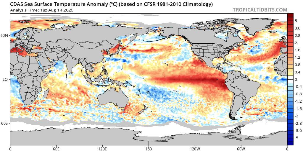
2026-2027 Record-breaking El Nino
GaWx replied to Stormchaserchuck1's topic in Weather Forecasting and Discussion
That’s where the great and long SOI monthly records can be useful. There’s a good -correlation between SOI and 3.4 SSTa. SOI goes way back to 1876. -
Viagra online price: MenCare Virtual - Cheap Sildenafil 100mg
-
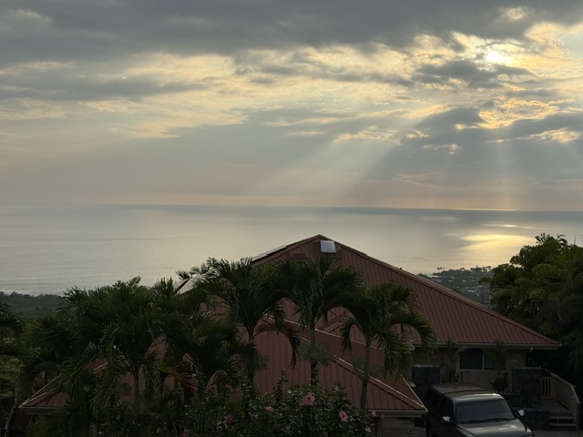
We were supposed to be in Volcano tonight, but the forecast there is for 15+ inches of rain plus the wind, and the town doesn’t have a particularly strong infrastructure so we rented a home in Kona instead up on the hill. ChatGPT says this should be the most sheltered spot on the island. As an added bonus it has a good 180 view to the West so it should be a fun spot to watch the hurricane from. Hopefully not too many issues. A bit bummed that I don’t get to spend any time in Volcano, I love spending time in the rainforest there, but with 2 kids in tow and the possibility of being without power, water or even road access for days didn’t seem wise. But hey, it’ll be a trip of firsts: first lava fountain, first actual hurricane (assuming it does become a hurricane).
-
Hrmm...
-
(002).thumb.png.6e3d9d46bca5fe41aab7a74871dd8af8.png) So let's address Charlie @chubbs post above Charlie, of course no dispute that Phoenixville stepped down at the 1948 move. But you've written the very objection into your own post: "Not surprising because the bias adjustments are calculated from the raw data." Charlie, your test is pairwise comparison of a target against raw neighbors across a break date. But so is the PHA! You've actually hand-implemented the method NCEI automates. Agreement demonstrates reproducibility, but of clearly not correctness as you are simpling showing us the same method, same data. It's the same issue as Berkeley and NCEI agreeing being offered as independent confirmation - they are of course not! On your "bullet proof" claim - the four available estimates of this one documented move: Berkeley -1.23 F / yours vs Coatesville -1.49 F NOAA -1.88 F / yours vs West Chester -2.03 F Four pairwise estimates of the same event spanning 0.80 F; the largest is 65% bigger than the smallest. Same sign and rough scale but the real question here as always has been the magnitude is what's in dispute here, and that spread isn't what bullet proof looks like!!. Also, your 2 references disagree by 0.54 F. If both were stable through 1947-50 they should agree on that Phoenixville's step. They don't, so they moved relative to each other in your window - and you date West Chester to 1970 and Coatesville to 1946, before your "before" period even opens. So you also say "all of the major county COOP stations moved in the same direction and roughly the same magnitude after the war". If so, doesn't that actually represent a real problem for the method, not support for it??. Pairwise comparison sees only RELATIVE change - a shift common to the whole network differences out and is invisible by construction. The more synchronised those moves were, the less your test and the PHA can detect, in exactly the era carrying the county's largest adjustments. So Charlie while none of this says your step estimate wrong. It means the method you are using is simply being validated against itself, the spread across implementations exceeds the confidence claimed, and the scenario you offer as clinching is the one the method handles worst.!! Paul
So let's address Charlie @chubbs post above Charlie, of course no dispute that Phoenixville stepped down at the 1948 move. But you've written the very objection into your own post: "Not surprising because the bias adjustments are calculated from the raw data." Charlie, your test is pairwise comparison of a target against raw neighbors across a break date. But so is the PHA! You've actually hand-implemented the method NCEI automates. Agreement demonstrates reproducibility, but of clearly not correctness as you are simpling showing us the same method, same data. It's the same issue as Berkeley and NCEI agreeing being offered as independent confirmation - they are of course not! On your "bullet proof" claim - the four available estimates of this one documented move: Berkeley -1.23 F / yours vs Coatesville -1.49 F NOAA -1.88 F / yours vs West Chester -2.03 F Four pairwise estimates of the same event spanning 0.80 F; the largest is 65% bigger than the smallest. Same sign and rough scale but the real question here as always has been the magnitude is what's in dispute here, and that spread isn't what bullet proof looks like!!. Also, your 2 references disagree by 0.54 F. If both were stable through 1947-50 they should agree on that Phoenixville's step. They don't, so they moved relative to each other in your window - and you date West Chester to 1970 and Coatesville to 1946, before your "before" period even opens. So you also say "all of the major county COOP stations moved in the same direction and roughly the same magnitude after the war". If so, doesn't that actually represent a real problem for the method, not support for it??. Pairwise comparison sees only RELATIVE change - a shift common to the whole network differences out and is invisible by construction. The more synchronised those moves were, the less your test and the PHA can detect, in exactly the era carrying the county's largest adjustments. So Charlie while none of this says your step estimate wrong. It means the method you are using is simply being validated against itself, the spread across implementations exceeds the confidence claimed, and the scenario you offer as clinching is the one the method handles worst.!! Paul -
First legit rainy day in forever here. Rained basically non stop for 5 hours.
-

Augdewst 2026: Summer's Last Stand
HIPPYVALLEY replied to Prismshine Productions's topic in New England
Streams are low again around here. All showers have been a miss in Greenfield this week. Decent summer week tho' -
I actually like the call for minimal hurricane on the closest approach. Though the discussion mentioned not much change in organization or intensity in the past six hours, Lala's core structure is starting to show some interesting signs it may be about to begin a period of intensification. Over the past several hours, organizing banding is wrapping near the CoC. Additionally, some deeper convection is now firing within that interior band, and radar also suggests a shallow ring is evolving. SSTs are running above 27-27.5°C at that location, which is above normal aided by the strengthening El Niño. I'd favor steady intensification now despite any lingering dry airmass and status quo at this point.
-
viagra canada: Buy Viagra online cheap - Cheap generic Viagra
-
best price for viagra 100mg [url=https://mencarevirtual.shop/#]MenCare Virtual[/url] buy Viagra online
-

2026 C and E Pacific tropical activity
WxWatcher007 replied to GaWx's topic in Tropical Headquarters
Tropical Storm Lala Discussion Number 11 NWS Central Pacific Hurricane Center Honolulu HI CP012026 Issued by NWS National Hurricane Center Miami FL 500 PM HST Fri Aug 14 2026 Lala has changed little in organization during the past several hours, with most of the deep convection remaining over and north of the center. However, data from NOAA and Air Force Reserve Hurricane Hunter aircraft indicate that the cyclone has strengthened some this afternoon. Pressure observations from nearby NDBC buoy 51004 have also been useful in assessing the cyclone as it passes close to the station. Based on a blend of the aircraft data, buoy observations, and overall satellite presentation, the initial intensity is set at 55 kt. The initial motion is west-northwestward, or 290/10 kt. A mid-level high pressure system anchored north of the Hawaiian Islands should continue to steer Lala generally west-northwestward during the next several days. Some slowing of the forward motion is possible as the cyclone approaches the Big Island and begins to interact with the island's terrain on Saturday. Short-term deviations in the track are also possible during this time. After passing near or over the southern portion of the Big Island, Lala could make a subtle turn toward the northwest in the lee of the island before resuming a west-northwestward motion south of the smaller islands through the remainder of the weekend. The latest NHC track forecast is very similar to the previous advisory and remains close to the mult-model consensus (HCCA) and the Google DeepMind ensemble mean. Some additional strengthening is forecast during the next 12 to 24 h while environmental conditions remain generally favorable. Although mid-level dry air continues to be a limiting factor, the inner circulation could become somewhat more compact and organized as Lala approaches the southern portion of the Big Island. The NHC forecast therefore continues to show Lala reaching hurricane strength near the time it reaches the Big Island on Saturday. Interaction with the island's terrain should then disrupt the low-level circulation and result in weakening, with increasing vertical wind shear associated with an upper-level low providing an additional negative influence later in the weekend. Some re-strengthening is forecast early next week as vertical wind shear relaxes and Lala remains over warm sea surface temperatures. The latest NHC intensity forecast is similar to the previous advisory and remains near the middle- to upper-end of the guidance envelope. Key Messages: 1. Damaging hurricane-force winds are expected on the Big Island of Hawaii Saturday, with the strongest wind gusts expected in areas of higher terrain. Preparations should be rushed to completion this evening before tropical-storm-force winds begin. Tropical-storm-force winds are also expected across portions of the smaller islands this weekend. 2. Heavy rainfall will reach the Big Island this evening and spread westward across the remainder of the island chain this weekend. This rainfall may produce life-threatening flooding and mudslides, especially in areas of steep terrain. 3. Large and dangerous waves are expected across portions of the Hawaiian Islands this weekend. Surf is already building along east-facing shores and will increase along exposed southern shores as Lala passes through the region. This heavy surf may cause localized coastal flooding and significant beach erosion. FORECAST POSITIONS AND MAX WINDS INIT 15/0300Z 17.6N 152.4W 55 KT 65 MPH 12H 15/1200Z 18.0N 154.0W 60 KT 70 MPH 24H 16/0000Z 18.8N 155.7W 65 KT 75 MPH 36H 16/1200Z 20.0N 158.6W 60 KT 70 MPH 48H 17/0000Z 20.7N 161.4W 55 KT 65 MPH 60H 17/1200Z 20.9N 163.8W 55 KT 65 MPH 72H 18/0000Z 21.0N 166.1W 60 KT 70 MPH 96H 19/0000Z 21.5N 170.0W 65 KT 75 MPH 120H 20/0000Z 22.8N 173.3W 70 KT 80 MPH $$ Forecaster Gibbs -
1.3" on the day. Hoping for a repeat tomorrow.
-

2026-2027 Record-breaking El Nino
forkyfork replied to Stormchaserchuck1's topic in Weather Forecasting and Discussion
so the strongest nino in almost 300 years. damb -
That is a great answer Mike! that transformer efficiency improving over time means declining waste heat, which puts spurious cooling into the raw record, which needs the later data warmed. That's the sign NCEI applied. It's a coherent mechanism and it's the first one offered in this thread that resolves the direction problem. Thank you for it. However....I think it may cost you a bit more than you think this buys you! A few posts ago your position was "100% documented evidence of microsite impacts" and "Coatesville's breakpoints are fully documented at this point." Now the site is "literally a thermal zoo" and the complexity "obviates all the musings about what caused a precise shift at time X and magnitude Y." Those are different arguments. The first says the causes are documented and therefore the corrections are validated. The second says the causes can't be pinned down and therefore we have to trust the detector. I don't think both can be true of the same station, and the second is a much weaker claim than the one you started with. It also runs into my actual objection rather than around it. If the microsite is too complex to attribute a given shift to a given cause, then it is also too complex to verify that the correction applied was the right size. You're offering unverifiability as a reason for confidence. Unverifiability is the thing I've been objecting to. And your mechanism argues against the correction's shape. Transformer technology improving across decades is gradual. A cooling pool installed at one point and removed after 2005 is two events. Steadily declining waste heat produces a ramp, not a staircase. The PHA fits steps. By your own account the physical signal is the wrong shape for the correction being applied to it - and that's your description of the site, not mine. There's a specific case I'd like your read on. The 1946-01 changepoint is +0.79 C, warming everything from 1946 forward. That's the move TO Newlinville. If the station relocated onto a substation with massive transformers and high loads, the raw record should have jumped warm at that moment and needed a cooling correction. NCEI warmed it instead. That only works if Newlinville was cooler than the water plant site it came from - which is your earlier "hot location to progressively cooler ones" account, and I don't see how it sits alongside "massive heat sources" at the same site in the same year. Last thing, If Coatesville 1SW spent 36 years in a thermal zoo with industrial heat sources that moved, changed technology, and gained and lost a cooling pool, there's a conclusion available that neither of us has put on the table: that this record can't be salvaged for trend estimation and shouldn't be used for it. "Automated detection is the only way to salvage this data" assumes it can be salvaged. What's the basis for that, given everything you've just described? And is it a kind of a funny coincidence that the station carrying the county's largest adjustments is the one you're describing this way? Paul
-
super el nino banter thread
forkyfork replied to forkyfork's topic in Weather Forecasting and Discussion
all you need is one good storm track with just enough cold air <3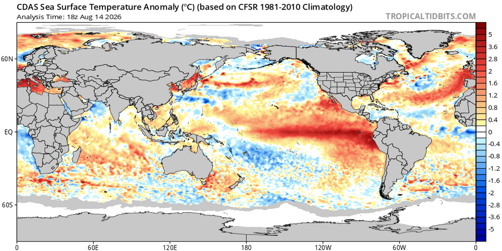
-
super el nino banter thread
forkyfork replied to forkyfork's topic in Weather Forecasting and Discussion
+4 lol -

2026 C and E Pacific tropical activity
NorthHillsWx replied to GaWx's topic in Tropical Headquarters
If anyone’s followed models or honestly just looked at the system and avoided social media it’s been very apparent for days this will be an upper-tier TS or bottom line cat 1 hurricane when it makes its closest approach. Based on what I’ve seen it likely skirts just south of the big island. Nothing shocking or surprising has happened this system has largely followed the forecast, though I agree at present it would seem to be unlikely this reaches hurricane intensity before its closest approach -
https://mencarevirtual.shop/# MenCare
-
https://mencarevirtual.shop/# MenCare Cheap generic Viagra
-
looks like the largest rainy day/night for E Colorado in a long while