All Activity
- Past hour
-
For you?
-

February 2026 Medium/ Long Range Discussion: Buckle Up!
Weather Will replied to Weather Will's topic in Mid Atlantic
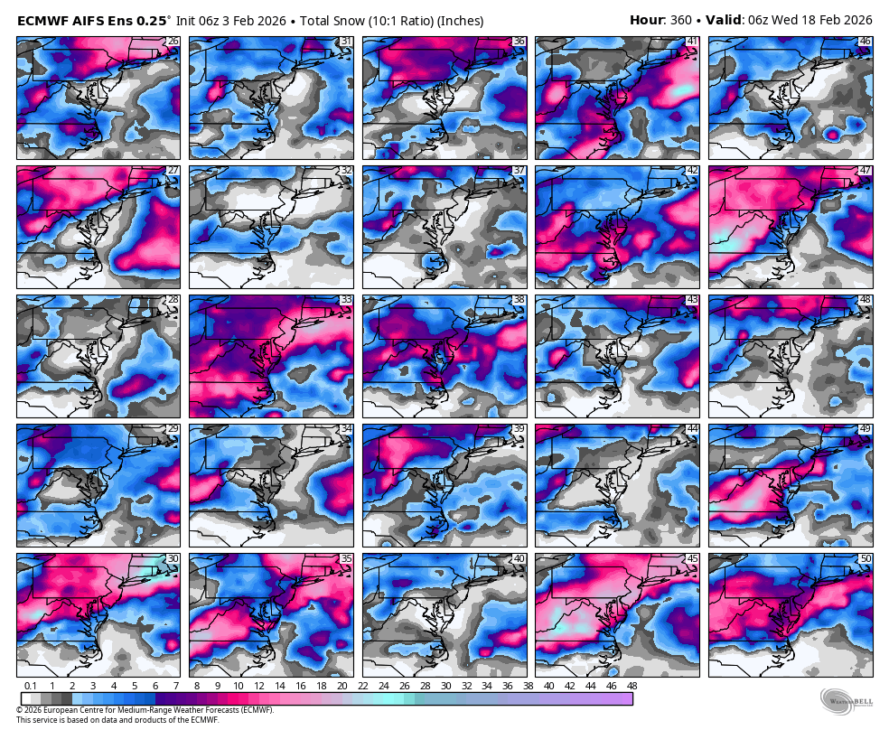
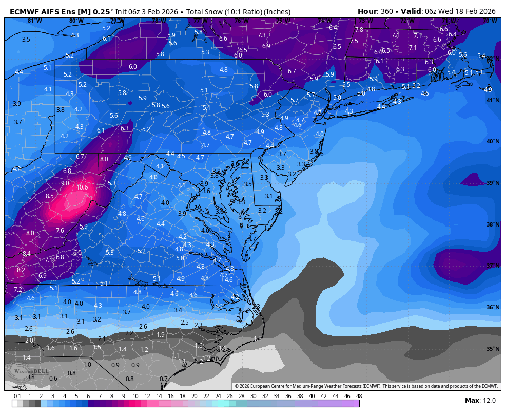
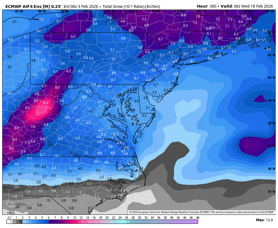
WB 6Z AI EPS has lots of hits to our south in the extended. Not a shut out look.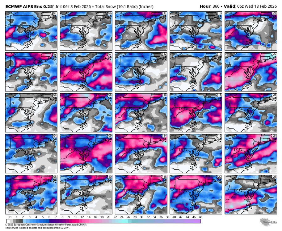

-
So finally creeped just above freezing yesterday with a 33.0 high first time in 10 days. Was above 32 for about an hour. With only 10 mph winds it felt like 60 lol. MUCH warmer overnight, never went below 20 degrees here, that also is a first in about 10 days.
-

2025-2026 ENSO
40/70 Benchmark replied to 40/70 Benchmark's topic in Weather Forecasting and Discussion
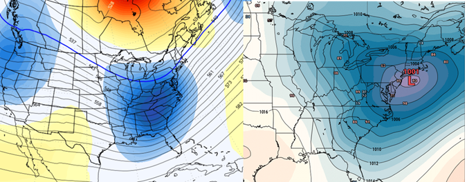
Looks like the main PV lobe is headed to Asia. Looks like the airmass grows rather stale on this side of the hemisphere beyond about Feb 10th. -
 Once again... way warmer than you for my house. 12F this morning
 -
 ICON was west too. GFS brings it straight in.
 -

E PA/NJ/DE Winter 2025-26 Obs/Discussion
MickeyTim6533 replied to LVblizzard's topic in Philadelphia Region
-

Feb 4-5 significant SE snow threat
WinstonSalemArlington replied to GaWx's topic in Southeastern States
-
That was 00z.
-
Looks like 2-3 on euro Friday night with more on cstl PYM county.
-
.thumb.jpg.6a4895b2a43f87359e4e7d04a6fa0d14.jpg)
Central PA Winter 25/26 Discussion and Obs
Yardstickgozinya replied to MAG5035's topic in Upstate New York/Pennsylvania
Mood flakes are flying here. Nice size flakes. Good call, SnowNuts. -
Is we back? February discussion thread
40/70 Benchmark replied to mahk_webstah's topic in New England
Yea, probably a great pattern for NNE. -
Is we back? February discussion thread
40/70 Benchmark replied to mahk_webstah's topic in New England
I guess I sensed an optimistic tone in your interpretation. Agree concerning volatility, but I think the correction vector in terms of at least the middle third of the month is warmer. Hopefully I'm wrong. -
Meh.
-
I am somewhat intrigued by the AI more wintry scenarios and the ensembles included. They’ve performed well lately.
-

February 2026 Medium/ Long Range Discussion: Buckle Up!
Chris78 replied to Weather Will's topic in Mid Atlantic
Yeah. Hopefully it's a quick relaxation rather than a 2 week+ change that would come close to closing down the 2026 snow season lol. For MBY I kind of want the moisture first and hope temps work. Probably the opposite of the low lands. My area has gotten burnt the last several years from south and east storm tracks. I'm not really sure what to root for anymore honestly lol. -

Is we back? February discussion thread
Damage In Tolland replied to mahk_webstah's topic in New England
If that Fri night low digs that far south.. it’s gonna snow -
Central PA Winter 25/26 Discussion and Obs
Yardstickgozinya replied to MAG5035's topic in Upstate New York/Pennsylvania
Oh snap !! When you and blizz team up, for a good one, I expect at least 3 solid inches. -

Central PA Winter 25/26 Discussion and Obs
pasnownut replied to MAG5035's topic in Upstate New York/Pennsylvania
NWS had my only chance at breaking freezing to be today. Yesterday they had me at 33 for the high. today they throttled it back down to mood flakes and 26. Despite the "boring" cold, we have a decent chance at statewide flakes friday and wont see above freezing for the next 7-8 days. Solid winter continues. Thanks for saving what you gave us Mo Nature. -
You guys are a lock imho
-
Optimism? Just my interpretation. The way LR models flip there is zero Optimism.
-
I'm sorta done with the cold, but gladly take some more sn as we head towards the backside of winter
-

January 30th- Feb 1st ULL and coastal storm obs
SUNYGRAD replied to JoshM's topic in Southeastern States
Rapid Reaction: A Statewide Snowstorm for the Ages - North Carolina State Climate Office -
Yea heights around 540 instead of 520 but with SWFE implications. Looking forward to a warm up
-
here's your VD transmission day event in the Canadian ensemble. GEFs and EPS have nothing coherent above the background static noise left over after the big bang for their handling between the 14 and 15th. The numerical indices have no interest, either. In fact, -d(PNA), +EPO, neutralizing NAO support at minimum alleviation of cold. I think we're seeing that pretty clearly enough in the general cinemas of the operational models out there toward the middle of the month. There is/was one operational run, the 06z GFS, as I'm sure this remarkable storm attentive group of people have already exposed. So, it is what is for the time being. Not much support from most of what's out there, with a short list of sources doing more.