All Activity
- Past hour
-

Possible Light Snowfall (1" - 3") on Tuesday Dec 23
Northof78 replied to Northof78's topic in New York City Metro
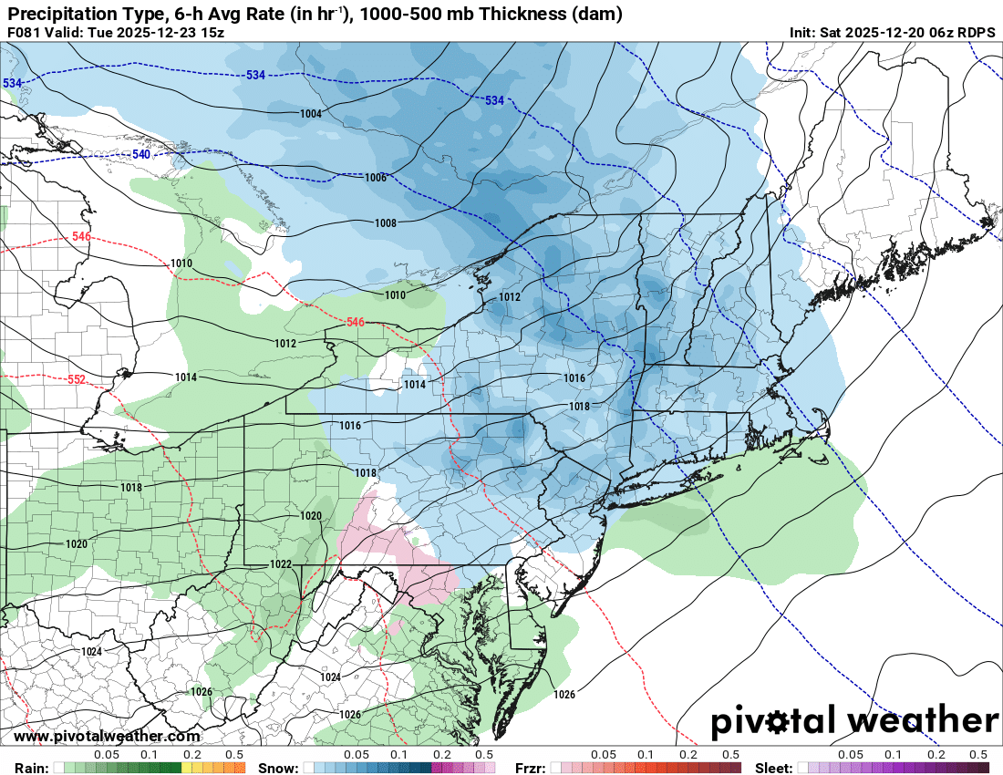
6z GFS ups the ante, more moisture and a more robust system seems to be the trend. 2-4" for much of the forum -

Possible Light Snowfall (1" - 3") on Tuesday Dec 23
MJO812 replied to Northof78's topic in New York City Metro
Here is the rgem
.thumb.png.e63bb008cc03a1d5dcb3022d0a978606.png)
-
6z euro more with the inv trough look into srn Me and central NH.
-

Central PA Winter 25/26 Discussion and Obs
canderson replied to MAG5035's topic in Upstate New York/Pennsylvania
Found my downspout extenders. The wind took both off the end of my downspouts and blown them across the street into a field. -

Central PA Winter 25/26 Discussion and Obs
mahantango#1 replied to MAG5035's topic in Upstate New York/Pennsylvania
Still over 16,000 customers of PPL without power this morning. 17 this morning. -
The redevelopment on the AI models is nice to see. Would keep flow from ripping out of the SW at 850 and below. Seems like op runs so far are slowly migrating to that idea.
-
Possible Light Snowfall (1" - 3") on Tuesday Dec 23
MJO812 replied to Northof78's topic in New York City Metro
He think he is always right but he has been wrong more than he has been right. The block is giving the models a hard time. Models look better as we end of the year. Unfortunately Christmas should be milder this year. -
6z GEFS has the same general idea- energy ejecting eastward with confluence under the block.
-
Don’t be so hard on yourself as you are one of the best forecasters on here. When I saw how extreme the December2015 forcing for an El Niño in the WPAC was leading to the +13.3 in NYC, it caused me to gain a ton of respect for what has been occurring in the WPAC. https://phys.org/news/2021-04-distinctive-mjo-super-el-nino.html A research group, led by Dr. Wenjun Zhang from the Nanjing University of Information Science and Technology analyzed MJO activity of the super El Niño event during the Northern Hemisphere winter of 2015/16. Observations show that the western Pacific MJO activity was strongly suppressed during the peak phase of the 1982/83 and 1997/98 super El Niño events. However, during the crest of the 2015/16 super El Niño event, western Pacific MJO-related convection was enhanced. "It is apparent that the enhanced western Pacific MJO is mainly related to its sea surface temperature (SST) anomaly distribution and the associated background thermodynamic conditions." said Dr. Zhang. His team's complete research and data are published in Advances in Atmospheric Sciences. When compared to the previous super El Niño events, the warm SST anomaly, or change from average, of the 2015/16 El Niño was located more westward than during the other two extreme seasons. Additionally, no significant cold SST anomaly was detected in the western Pacific. Accordingly, the moisture and air temperature tended to increase in the central-western Pacific during the winter of 2015/16 unlike the previous super El Niño events. This research highlights that climatologists should consider the SST anomaly distribution of super El Niño events for future MJO activity studies.
-

December 2025 regional war/obs/disco thread
Sey-Mour Snow replied to Torch Tiger's topic in New England
GFS and Euro really beefing up qpf for Tuesday morning .. nice .2-.4” qpf event with some spots up to .5” -
Yup we take!!
-
AI models certainly would.
-

Possible Light Snowfall (1" - 3") on Tuesday Dec 23
SnoSki14 replied to Northof78's topic in New York City Metro
I don't know what his problem is. Dude hates snow/cold. So maybe we'll get an inch of snow. Pattern looks pretty bad afterwards, he should be thrilled. -

Central PA Winter 25/26 Discussion and Obs
Voyager replied to MAG5035's topic in Upstate New York/Pennsylvania
Mine is quite sheltered too. I had a peak wind gust of only 16.2 mph yesterday in my backyard. -
6z GFS does deliver some frozen/freezing precip for end of the month period but who cares about the details this far out- keep advertising NA looks like this with a bowling ball rolling across the south and we stay interested.
-
Possible Light Snowfall (1" - 3") on Tuesday Dec 23
MJO812 replied to Northof78's topic in New York City Metro
6z euro and 6z ai

-
He sets an alarm when I post
-
Our annual warm up over 55° between 12-17 and 12-25 was right on schedule. This pattern has become more pronounced over the years. While the general pattern did exist prior to 2011, this is the first 15 year run with no interruption. The last time we didn’t see this warm up was back in 2009 and 2010. Data for December 19, 2025 through December 19, 2025 Click column heading to sort ascending, click again to sort descending. CT DANBURY MUNICIPAL AP WBAN 60 NJ NEWARK LIBERTY INTL AP WBAN 59 NJ TETERBORO AIRPORT WBAN 59 NJ CALDWELL ESSEX COUNTY AP WBAN 59 NY ISLIP-LI MACARTHUR AP WBAN 59 NY RIVERHEAD RESEARCH FARM COOP 59 NY LAGUARDIA AIRPORT WBAN 58 NY NY CITY CENTRAL PARK WBAN 58 NY MONTGOMERY ORANGE COUNTY AP WBAN 58 CT NEW HAVEN TWEED AP WBAN 58 CT MERIDEN MARKHAM MUNICIPAL AP WBAN 58 NY FARMINGDALE REPUBLIC AP WBAN 57 NY JFK INTERNATIONAL AIRPORT WBAN 57 CT IGOR I SIKORSKY MEMORIAL AIRPORT WBAN 57 NY WESTCHESTER CO AP WBAN 57 NY SHIRLEY BROOKHAVEN AIRPORT WBAN 57 NY BAITING HOLLOW COOP 57 NY UPTON COOP - NWSFO NEW YORK COOP 57 CT NORWICH PUBLIC UTILITY PLANT COOP 57 NJ HARRISON COOP 56 NJ TETERBORO AIRPORT COOP 56 NY ST. JAMES COOP 56 CT GROTON NEW LONDON AP WBAN 56 NY CENTERPORT COOP 55

-
Just like every year!
-
E PA/NJ/DE Winter 2025-26 Obs/Discussion
Voyager replied to LVblizzard's topic in Philadelphia Region
Up my way in northern Lehigh and Schuylkill Counties, downed trees, wires, and even some snapped power poles in New Tripoli on PA309 played havoc with the last two deliveries of my trucking work shift. -

December 2025 regional war/obs/disco thread
Damage In Tolland replied to Torch Tiger's topic in New England
Should be enough to give white Cmas -
AI models argue for some more though over ern areas just away from the water. Especially NE Ma.
-
Anything above 3 is north.
-
OT, but I am impressed at how rapidly snowman19 throws a weenie tag on @MJO812. Initial post was 31 minutes ago, followed by the weenie 26 minutes ago. All happening before 6:00 am on a Saturday It’s almost like you guys have each others accounts linked.
-
December 2025 regional war/obs/disco thread
Damage In Tolland replied to Torch Tiger's topic in New England
2-5”
.png.326ab1d3ce6ebee511a4bf334f4cf125.png)


