All Activity
- Past hour
-
Oh man! That ain’t good!
-
First time playing Mahomes?

-
 Kind of agree... still not to give up hope since neg tilt, instability aloft. In bands... probably best eastern PA into central NYS northwest of the 850 low, but all modeling continues with beneficial amounts for the forum. Impossible for me to know for sure... ensembles (esp EC and ECAI ae larger than I anticipated when looking at their 00z/28 ops).
 -
https://www.youtube.com/live/k4Lt_iev8x4 Here's live video of the Flat Bridge (would just be off to the NW of this map N of Spanish Town). You can rewind showing the water level rise over the last 8 hours to where the bridge is now almost completely overtopped.
-
“The next few days will see a polar vortex strengthen due to less solar radiation. However, to date it seems temporary with a zonal deceleration towards December. The eQBO maintains a weak polar vortex, but without support from the EPflux with Eddys momentum and heat fluxes, it will be difficult to get cold in the mid-latitudes. In this case, the MJO or tropical convention will play a key role in the dynamics of heat fluxes in the polar vortex if it propagates towards the Pacific with good amplitude in December. A W1 pattern over the Pacific seems likely with December. Obviously, if the MJO does not propagate over the Pacific Ocean, there will be no convergent heat fluxes that make the PV weak, and this will be a problem.”: “A negative QBO phase always lifts hopes for mid-latitude winter cold enthusiasts, owing to its influence on the stratospheric PV. But the QBO's links to surface weather are not simple. Perhaps surprisingly, during La Niña a -QBO is warmer than a +QBO in early winter in N Europe”:
-

Spooky Season (October Disco Thread)
kdxken replied to Prismshine Productions's topic in New England
Weirdly the national weather services no. "In terms of impacts there are few changes to make from the previous update. While the system will be progressive in nature, most areas can expect a widespread 1-3" of rainfall. NBM 90th percentile guidance shows a reasonable worse case scenario with a widespread 2-4 inches of rain falling. We should note that DESI is indicating some low probabilities of 4+ inches of rain with this system. -
 Hoping we get decent rain east of the city since it’s still needed. Looking like the best rain may be setting up west of us again.
 -

Spooky Season (October Disco Thread)
CoastalWx replied to Prismshine Productions's topic in New England
It’s just a front moving through, to me it was always half inch to an inch give or take a little bit. -
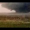
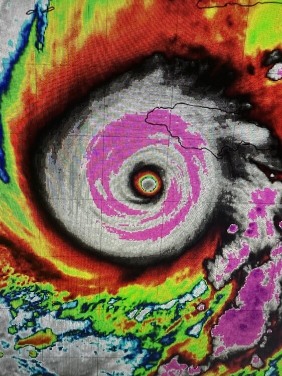
Pinpoint eye and significant Lightning visible in this image capture. Just a monster of a storm.
-
Oooof
-
lol they won’t. Sub 500 season ahead. Oh well.
-
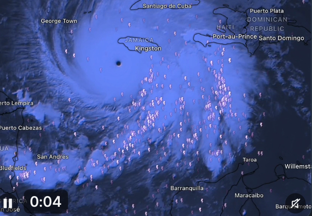
Flooding in Kingston already via this sat image from Copernicus

-
Spooky Season (October Disco Thread)
kdxken replied to Prismshine Productions's topic in New England
Did the models back off on the rainfall? My Google forecast has less than an inch. it was over two for Thursday yesterday. -
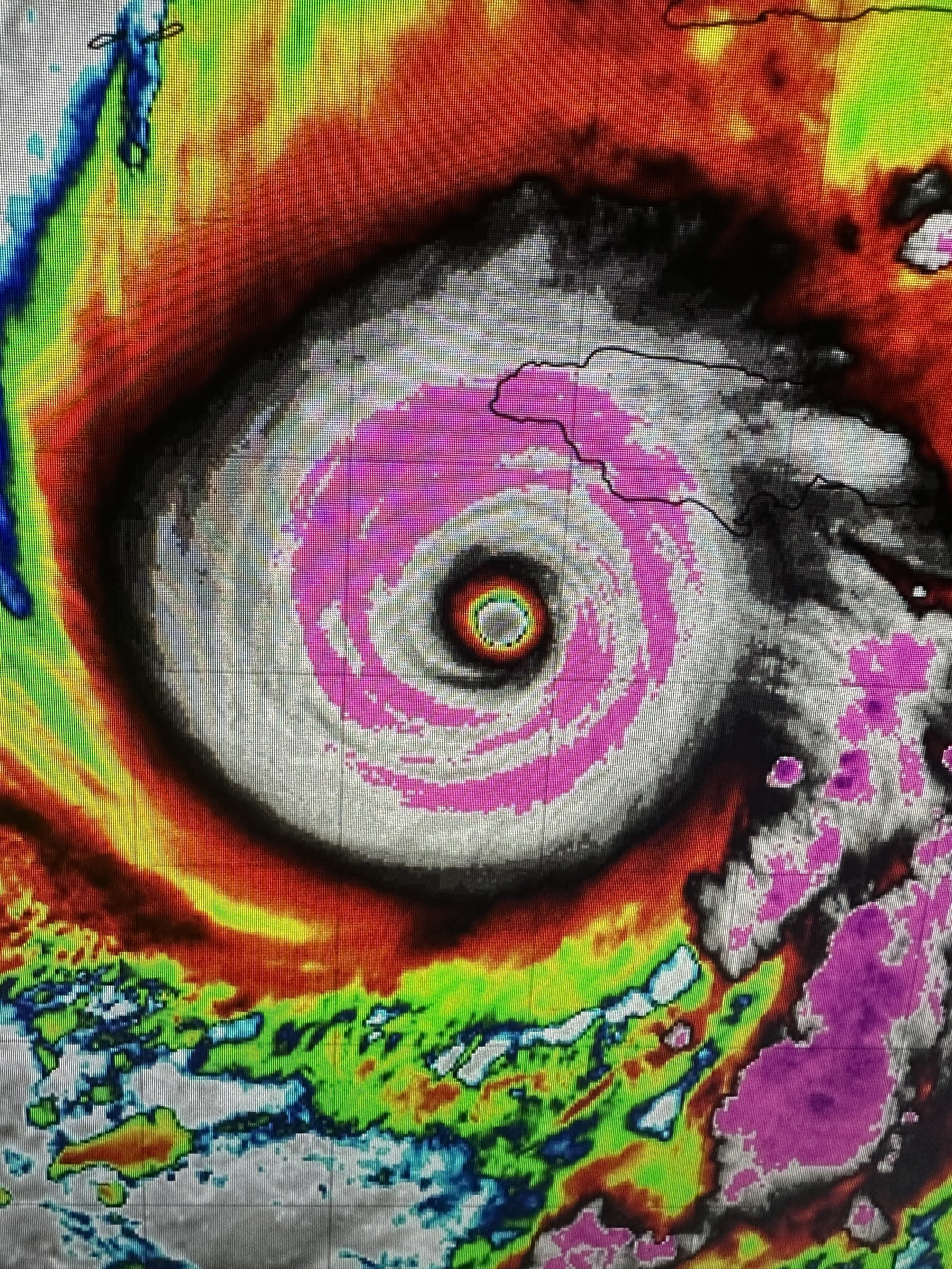
Thank you! Glad Kevin was able to grab an image. Yeah, Melissa's core has been one of the most resilient I can remember since perhaps Dorian and Irma at such a high intensity.
-
Also, Jamaica has already been getting pounded all night with that right front quad feeder band feeding off the central Caribbean. There appears to be a break in precip between the core and that wide, strong, convectively active feeder. That might help some, but totals are no doubt already adding up over the higher terrain to the central and eastern range.
-
These are the actual current anomalies, they have cooled but are still pretty warm
-

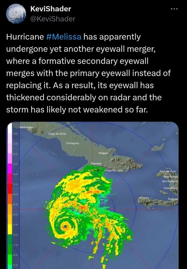
Major Hurricane Melissa - 903mb - 175mph
olafminesaw replied to GaWx's topic in Tropical Headquarters

-
I actually have bothered to look smart guy. It warmed back up in early November back then. I love how you suddenly appear here with insults after contributing absolutely nothing to this thread since it began. One of those who only posts from November through the end of March then disappears
- Today
-
There might be some impact from Melissa--adjusting the flow patterns, but for now... I'm not attributing Melissa indirectly -- I'd have to prove it w some science and that for me is not easily done. Speculation herein warranted but not for media as yes (gospel pronouncement). Basically what I see is a routine event Thursday... the 09z/28 WPC 3 day beneficial totals are within the 1 year repeat interval so its just a matter of impacts on travel. I don't see anything worse than thread headlined. Wind advisory coasts Thursday ahead of the low, and then maybe again behind it Friday afternoon-eve; scattered tree limbs down here and there for power outages, but not extensive unless we get a good squall-line (HSLC) event Thursday afternoon-evening. Coastal flooding limited to minor, imo-psurge values into minor have decreased on the GFS/GEFS/NAEFS. Therefore, its the previously exposed (Oct 12-13 event) coastal locations that seem most vulnerable to coastal flooding (NJ),. Still time to adjust but for now my anticipation has waned a bit due to the upper 5h low arcing northeastward through western-central PA.
-
Jamaica's radar sites are not pulling down. So I jumped to the only other radar site I could find that has the core. This is the tower in Pilon, Cuba. It is quite long range so the echoes are weak from this distance. However, you can still make out Melissa's very symmetrical eyewall. Especially compared to any returns adjacent to it. To my eyes, there may be a moat on the SW backside, but I don't really make out any signs of an EWRC yet. We are running out of time for such to do any damage to the core. It would need to already be underway by now. I'm starting to feel like this is definitely going to be a strong Category 5 strike.
-
Spooky Season (October Disco Thread)
CoastalWx replied to Prismshine Productions's topic in New England
Both gfs and euro have fairly impressive west winds Friday night. -
1.66 so far. .
-

Spooky Season (October Disco Thread)
ineedsnow replied to Prismshine Productions's topic in New England
First frozen in my point and click.. high of 47 going to be hard to get zr with that temp Monday A chance of rain or freezing rain. Partly sunny, with a high near 47. Northwest wind 5 to 8 mph becoming southwest in the afternoon. Chance of precipitation is 40%. -

Major Hurricane Melissa - 903mb - 175mph
Coach McGuirk replied to GaWx's topic in Tropical Headquarters
901 MB, 175 MPH. -
Major Hurricane Melissa - 903mb - 175mph
Coach McGuirk replied to GaWx's topic in Tropical Headquarters
Bad ass cat 5.