All Activity
- Past hour
-
1.68 here. Well needed rains for sure. But wow....it is chilly
-
We’ve had some maple leaf drop during the past few days. A bunch yesterday. not sure it is really unusual, but maybe a little early due to the lack of rain.
-
 Most, but not all of the area is below normal so far. I suspect that the entire region will finish below normal once August concludes. NYC will be solidly below normal.
 -
Seeing some swamp Maple turning. Sad.
-
Weather obs are not really a priority of mine right now.
-
0.1" yesterday, 0.6" MTD. she dry
-
1.74” here
-
 My area east of HVN has been at +0.5 for August so far. So a nice step down from the record heat in June and July. The last few days here have been the coolest of the month so far.
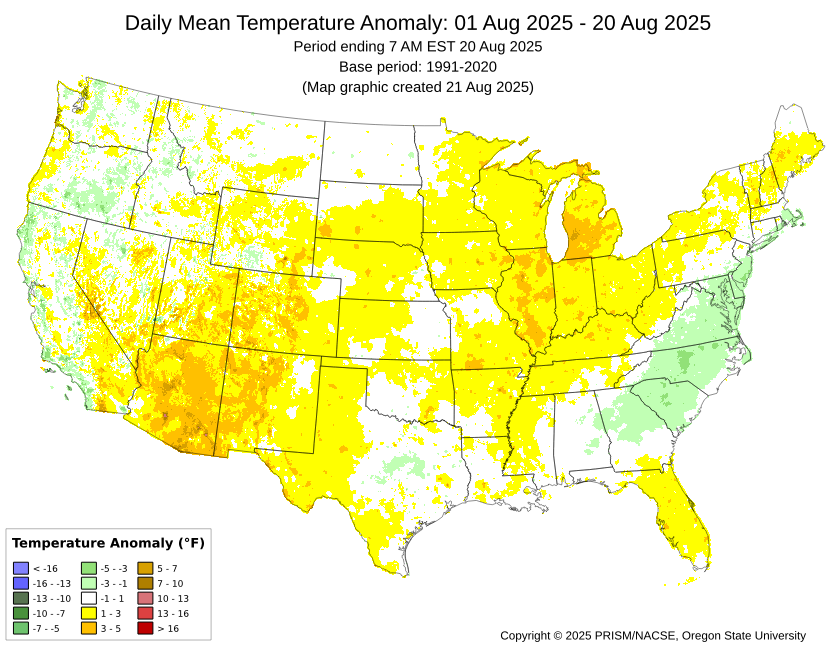
-
Lol from the guy who took 7 years to get his online
-
4.09 on the month. Most of that cane yesterday and Sunday nite in an hour
-
You’ve struggled with since you had. From cloggage to not knowing how to get it online . Wish you’d get it together
-
2.28” to bring the monthly total to 3.32”. Drought cancel.
-
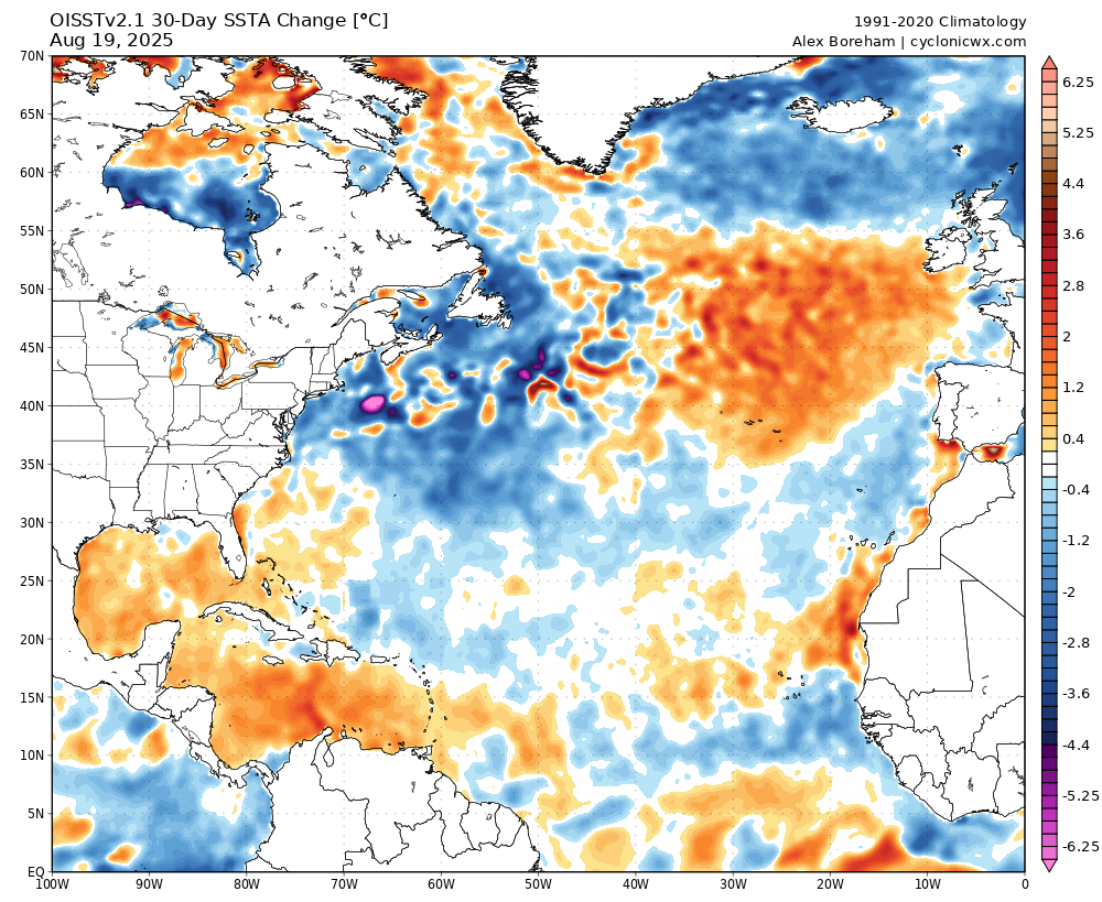
Cyclonicwx.com offers a 30 day change map fwiw.
-
 Arent we running BN for August?
 -
That 500mb anomaly map looks like the latest Euro seasonal.
-
Last week the forecast was for sunny weather for multiple days in a row despite any effects from Erin. This week at Dewey has been nasty. Constant cloud cover, mist, high winds, high waves. It has been a record in terms of high humidity and high dew points both nationally and globally.
-
This storm was like a surprise snow storm that just overperforms. Still raining. I cant wait to see precip amounts from on I 84 corridor
-
Were there any big totals as some of the models had?
-
Some localized heavier amounts here on the CT Shoreline and refreshing low maxes after all the heat and dry conditions this summer. Daily Precipitation Report Station Number: CT-FR-25 Station Name: Norwalk 2.9 NNW Data Explorer Observation Date 8/21/2025 7:00 AM Submitted 8/21/2025 6:38 AM Gauge Catch 1.75 in. Notes FallLike Day. 60s breezy. FINALLY RAIN!!! Started as mist late morning. Moderate in afternoon. Heavy at 11pm. Rained overnight. Misting at OBS Data for August 20, 2025 through August 20, 2025 Click column heading to sort ascending, click again to sort descending. GROTON NEW LONDON AP WBAN 1.58 NEW HAVEN TWEED AP WBAN 0.73 RECORD EVENT REPORT NATIONAL WEATHER SERVICE NEW YORK, NY 221 AM EDT THU AUG 21 2025 ...RECORD DAILY LOW MAXIMUM TEMPERATURE SET AT BRIDGEPORT CT... THE HIGH TEMPERATURE WAS ONLY 70 DEGREES WEDNESDAY, AUGUST 20 AT BRIDGEPORT SIKORSKY AIRPORT. THIS TIES THE OLD RECORD LOW MAXIMUM OF 70 DEGREES, SET IN 1990. RECORDS FOR THE BRIDGEPORT CT AREA GO BACK TO 1948. ALL CLIMATE DATA ARE CONSIDERED PRELIMINARY UNTIL REVIEWED BY THE NATIONAL CENTERS FOR ENVIRONMENTAL INFORMATION (NCEI).
-

Hurricane Erin: 110 MPH - 943 mb - N @ 13
MANDA replied to BarryStantonGBP's topic in Tropical Headquarters
This post explains a lot. -
Hurricane Erin: 110 MPH - 943 mb - N @ 13
MANDA replied to BarryStantonGBP's topic in Tropical Headquarters
Some people born obtuse and some stupid. Unfortunately, some are born both. -
I wish I kept track of how many cloudy, swamy mornings this summer. I was on the swim team as a kid. We practiced every morning. I never remember dreary mornings during summer. This summer has to be a record. Another dreary day. Yay
-
Yeah, I’m not far from that either. And we had a very, very wet July locally here too. So we’ve been decent in the water department aside from a few Stein stretches.
-

Hurricane Erin: 110 MPH - 943 mb - N @ 13
NorthHillsWx replied to BarryStantonGBP's topic in Tropical Headquarters
Family at nags head reports no overwash and very breezy conditions. Seems like highway 12 south of Oregon inlet took a beating like usual. -
I’m just going by the two gauges near me. Gotta unclog the stupid Davis.