All Activity
- Past hour
-
Intensity guidance keeps ticking up. Watch this be our 4th straight major hurricane on the season
-
Recon has been in Imelda and although it has not intensified much (there are stronger FL winds showing up now), it is confirming that the satellite appearance of more organization near the center is legit. Note that curved band of deep convection near the center, and how it is trying to wrap upshear. We'll see if the shear currently present keeps this organizational trend in check. Product: Air Force Vortex Message (URNT12 KNHC)Transmitted: 29th day of the month at 2:20ZAgency: United States Air ForceAircraft: Lockheed WC-130J Hercules with reg. number AF98-5307Storm Name: ImeldaStorm Number & Year: 09 in 2025 (flight in the North Atlantic basin)Mission Number: 20Observation Number: 09 ( See all messages of this type for this mission. )A. Time of Center Fix: 29th day of the month at 1:53:20ZB. Center Fix Coordinates: 24.74N 77.09WB. Center Fix Location: 27 statute miles (44 km) to the SE (142°) from Nassau, Bahamas.C. Minimum Height at Standard Level: 1,420m (4,659ft) at 850mbD. Minimum Sea Level Pressure: 998mb (29.47 inHg)E. Dropsonde Surface Wind at Center: From 160° at 3kts (From the SSE at 3mph)F. Eye Character: Open in the southeastG. Eye Shape & Diameter: Circular with a diameter of 25 nautical miles (29 statute miles)H. Estimated (by SFMR or visually) Maximum Surface Wind Inbound: 31kts (35.7mph)I. Location & Time of the Estimated Maximum Surface Wind Inbound: 80 nautical miles (92 statute miles) to the NE (46°) of center fix at 1:28:30ZJ. Maximum Flight Level Wind Inbound: From 104° at 46kts (From the ESE at 52.9mph)K. Location & Time of the Maximum Flight Level Wind Inbound: 75 nautical miles (86 statute miles) to the NE (45°) of center fix at 1:30:00ZL. Estimated (by SFMR or visually) Maximum Surface Wind Outbound: 28kts (32.2mph)M. Location & Time of the Estimated Maximum Surface Wind Outbound: 16 nautical miles (18 statute miles) to the SW (228°) of center fix at 1:58:30ZN. Maximum Flight Level Wind Outbound: From 344° at 38kts (From the NNW at 43.7mph)O. Location & Time of the Maximum Flight Level Wind Outbound: 35 nautical miles (40 statute miles) to the SW (228°) of center fix at 2:04:00ZP. Maximum Flight Level Temp & Pressure Altitude Outside Eye: 16°C (61°F) at a pressure alt. of 1,526m (5,007ft)Q. Maximum Flight Level Temp & Pressure Altitude Inside Eye: 20°C (68°F) at a pressure alt. of 1,525m (5,003ft)R. Dewpoint Temp (collected at same location as temp inside eye): 19°C (66°F)R. Sea Surface Temp (collected at same location as temp inside eye): Not AvailableS. Fix Determined By: Penetration, Radar, Wind, Pressure and TemperatureS. Fix Levels (surface & flight level centers within 5nm of each other): Surface and 850mbT. Navigational Fix Accuracy: 0.02 nautical milesT. Meteorological Accuracy: 4 nautical milesRemarks Section - Remarks That Were Decoded... Maximum Flight Level Wind: 46kts (~ 52.9mph) which was observed 75 nautical miles (86 statute miles) to the NE (45°) from the flight level center at 1:30:00Z Remarks Section - Additional Remarks... RAGGED EYEWALL 50% COVERAGE
-
The last 9 days of minimum temperatures: 39, 32, 30, 38, 60, 56, 60, 62, 58. Quite the whip-lash from crisp and frosty nights, to windows open all night. Don't need heat or AC though.
-
I disagree. The situation is different from before...they fired Billick back in 2007 when things got too bad. To me, things have never gotten THIS bad under Harbaugh--the failures are usually in the playoffs not this early in the season. This feels like it's leading to a "breaking point" moment; I have never seen players so defeated and looking like they've given up on the coaching before. I think this is different.
-

September 2025 OBS-Discussion centered NYC subforum
lee59 replied to wdrag's topic in New York City Metro
Down to 69 here, nice evening -

Spooky Season (October Disco Thread)
powderfreak replied to Prismshine Productions's topic in New England
Yeah, it's been a nice step down so far, but I agree that the upper level pattern looks to buck that trend in the long term. It wants to ridge out instead of the up and down of this month so far. -
So... There were similarities from the Summer of 1995 to this past Summer of 2025 ( although there was was a very small area of Tolland and Windham county that experienced above normal precipitation in July ). And we all know what happened in the winter of 1995/1996.... I'm not saying that's going to happen this winter, but, there were similarities ( During the summer of 2025 (June–August), Bridgeport, Connecticut, had its driest summer on record since 1948. The city recorded only 3.85 inches of rain during the entire season, surpassing the previous record of 4.13 inches set in 1995 ) During the summer of 1995, the Northeast experienced a severe drought and a notable heat wave in July, with August being especially dry. Overall, the season was significantly drier and warmer than normal, though regional variations occurred. Temperature A major heat wave in July was the most defining temperature event of the summer. Regional heat wave: Excessive heat and humidity spread into the northeastern United States by mid-July, after affecting the Great Plains and Midwest. Peak heat: The heat peaked around July 14, with temperatures in the 95–100°F range for some areas. The combination of heat and high humidity led to exceptionally high heat indices, exceeding 115°F in some locations. Persistent high temperatures: Some parts of the region experienced stretches of temperatures at or above 90°F during both June and August, in addition to the July heat wave. For example, locations from Philadelphia to Richmond saw 90+°F temperatures on 40 to 44 days during the summer. Above-normal averages: The average temperature for the summer was above normal for many areas, though not always drastically so. For instance, the Hartford, Connecticut, area had an average temperature of 72.2°F, which was just 0.3°F above normal. Precipitation A persistent and expanding drought was the key precipitation story of the summer, with August being exceptionally dry. Overall precipitation: The Northeast received 9.94 inches of precipitation, which was only 78% of the normal amount, making it the 19th-driest summer on record. Record dryness: Drought conditions intensified throughout the season, becoming moderate to severe by August. Many states experienced one of their driest summers or driest Augusts on record. Driest summer: New Hampshire had its driest summer on record, while Vermont had its second-driest. Driest August: Washington, D.C. experienced its driest August since 1871, receiving only 0.20 inches of rain. Vermont also had its driest August on record. Regional impact: The drought's intensity varied. For example, Bridgeport, Connecticut, recorded its driest summer on record with just 4.13 inches of rain. However, the nearby Hartford area was closer to normal for the season. August rainfall deficits: August precipitation was particularly low across the region, with significant rainfall deficits reported in nearly all states.
-

September 2025 OBS-Discussion centered NYC subforum
SnoSki14 replied to wdrag's topic in New York City Metro
Feels like a mid August night, not late September. And after the mild down later this week we're looking at another 5+ days of 80+ weather. Crazy stuff. Wild how a climate that's been stable for 1000s of years can change in less than half a lifetime. -
September 2025 OBS-Discussion centered NYC subforum
lee59 replied to wdrag's topic in New York City Metro
That one section of New Jersey can be such an outlier with warm days. -

Spooky Season (October Disco Thread)
WxWatcher007 replied to Prismshine Productions's topic in New England
I love fall and being in the Goldilocks zone for wx this time of year, so I’m with you on decent warmth—I just don’t like the upper level look. I want to see step downs. We keep saying these warm falls are fine and then I’m looking at +2 DJF and 30% of snow climo on March 15. I guess you could say I’m spooked - Today
-
 On vacation, luckily remembered to do this today on wife's computer (didn't bring mine). Bad thing is 1-took a while to remember the website log-in and 2-couldn't remember my password. FINALLY got in, lol. OK numbers for October DCA: +0.6 NYC: +0.7 BOS: +0.3 ORD: -0.2 ATL: +0.8 IAH: +0.5 DEN: -0.4 PHX: -0.2 SEA: +0.7
 -
Spooky Season (October Disco Thread)
powderfreak replied to Prismshine Productions's topic in New England
My feeling is that it isn't going to snow anyway, and it's getting darker earlier, so I enjoy the nice weather being outside as much as possible. My energy bill appreciates it with no AC or Heat. By early to mid November, I'm game for sustained normal to below weather for snowmaking. Have a full month+ though before it starts to matter. 48F and rain doesn't do much for me. -
September 2025 OBS-Discussion centered NYC subforum
lee59 replied to wdrag's topic in New York City Metro
81 the high here today -
Spooky Season (October Disco Thread)
WxWatcher007 replied to Prismshine Productions's topic in New England
I really don’t like this but if there’s a saving grace hopefully we snap back to troughing as we get closer to November. -
Spooky Season (October Disco Thread)
powderfreak replied to Prismshine Productions's topic in New England
That sounds about right as we head into the lower sun angle time of year. Mother Nature loves prolonging the sweet spot of temperatures in the 60-80F range as long as possible. -

Spooky Season (October Disco Thread)
kdxken replied to Prismshine Productions's topic in New England
Just found this guy. Seems reasonable -
Oh well, it's a dud and out to sea.
-
big 'uns
-
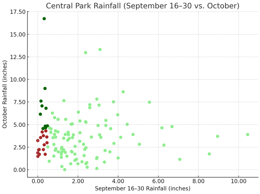
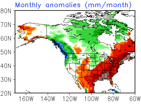
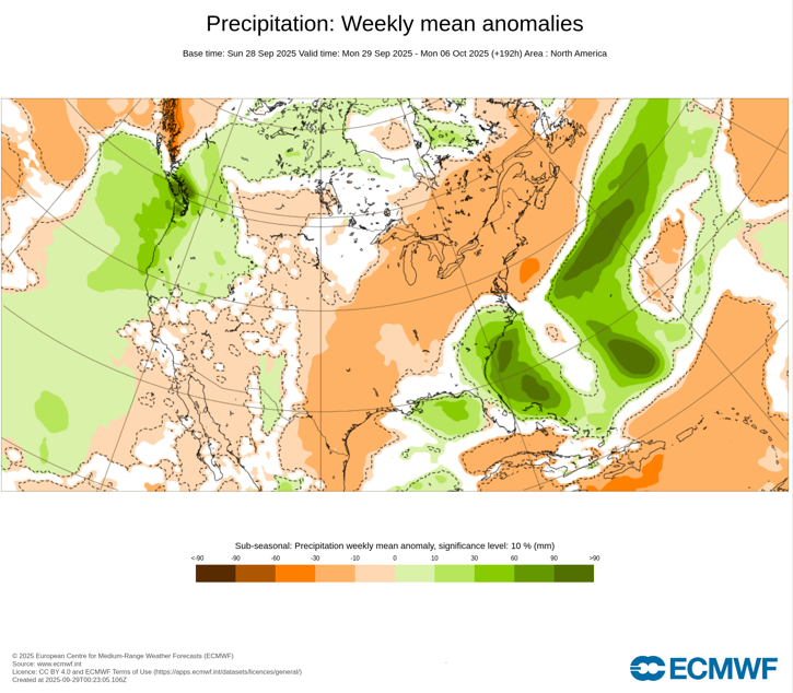
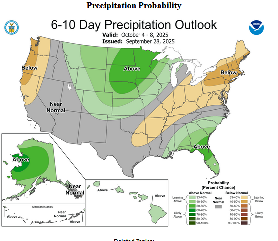
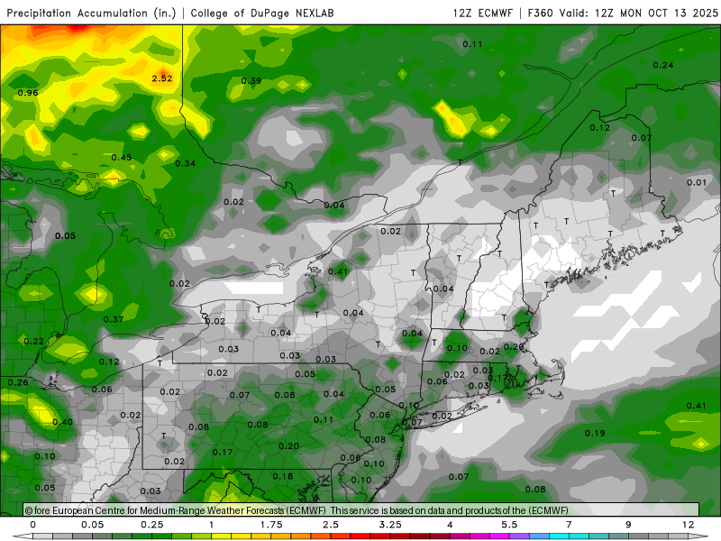
September 16-30, 2025 is on track to finish with 0.47" rainfall for Central Park. Since 1869, there have been 25 cases with 0.50" or less rainfall during the second half of September. Among those cases, 60% went on to have a drier than normal October while 40% went on to have a wetter than normal October. The latest CFSv2 monthly forecast shows a drier to much drier than normal October: The latest ECMWF weeklies also show a drier than normal start to October: CPC's 6-10-day precipitation forecast also favors drier than normal conditions: However, its monthly forecast from September 18th indicates equal chances of above or below normal precipitation. Finally, of the 8 years with mean temperatures of 70° or above during the second half of September coupled with < 1.00" rainfall, 75% were followed by a drier than normal October. The two exceptions were 2005 and 2019. All said, the odds lean toward a drier than normal October, but that isn't cast in stone.
-

Spooky Season (October Disco Thread)
H2Otown_WX replied to Prismshine Productions's topic in New England
-
The Euro weeklies control today flat out drops the hammer to begin November. There is some support from the ensemble. Yes, I know...waayy out there and huge grains of salt. Just wanted to share that winter is beginning to show up on some model runs at very long range as it should.
-
Category Five Hurricane Humberto
WxWatcher007 replied to WxWatcher007's topic in Tropical Headquarters
Shame they couldn't be there during the peak, but it's good to have data. -
2025 Atlantic Hurricane Season
WxWatcher007 replied to BarryStantonGBP's topic in Tropical Headquarters
Yeah Oct 7-20 is critical to my peak season forecast. I'm still thinking things heat up in the western Caribbean and Gulf during that period, and then we are winding down the season by the end of October. -
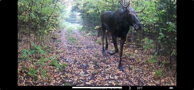
Couple of wildlife pictures. The first one was from a friend’s trail camera a few miles away from where we live and the second one was at the golf course today.

-
You can explain it to him but you can't make him understand. I've given up.


