All Activity
- Past hour
-
these don't do it for me, personally
-
 NorthTrust Pharm: п»їcanadian pharmacy uk delivery - legitimate canadian pharmacy online
 -
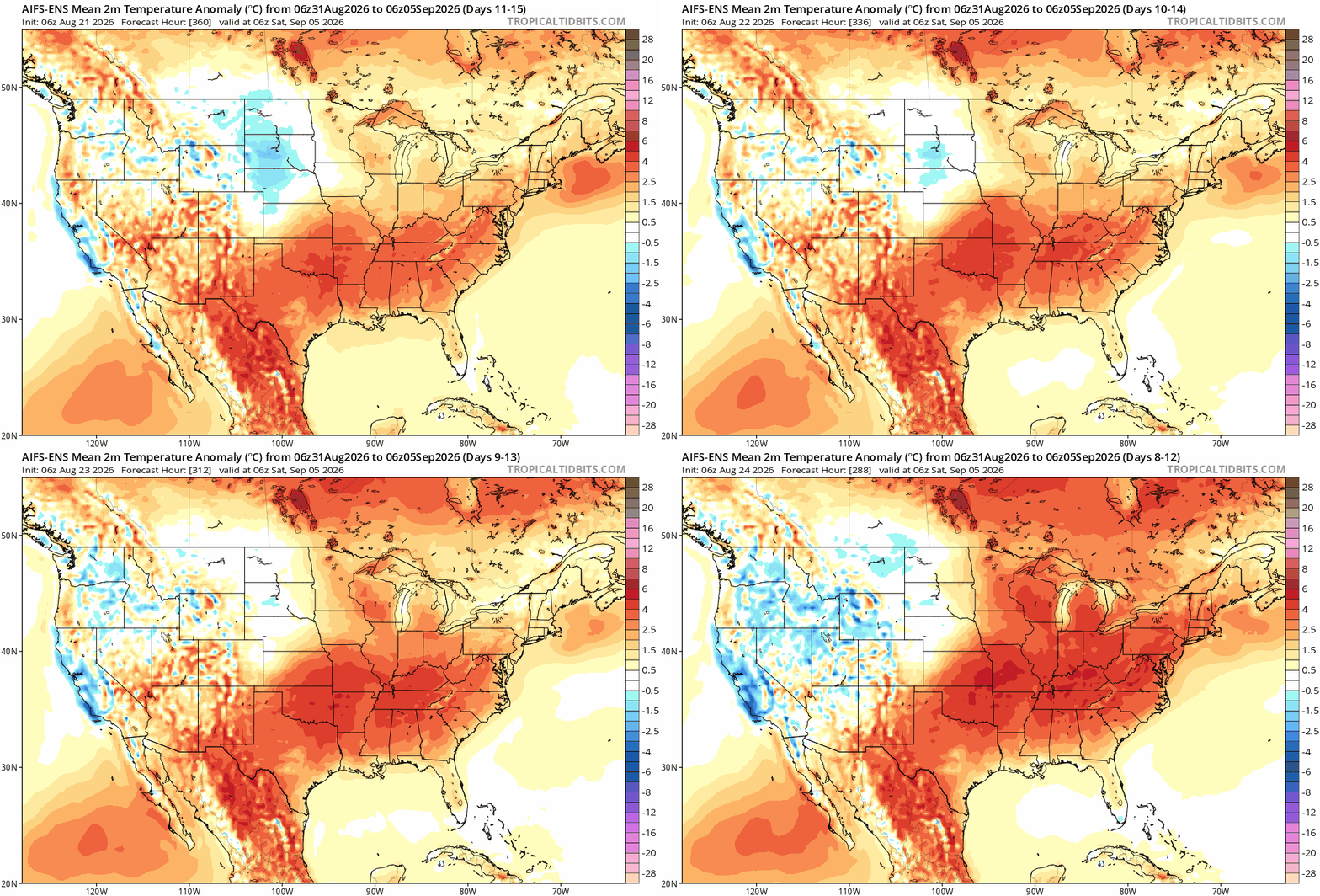
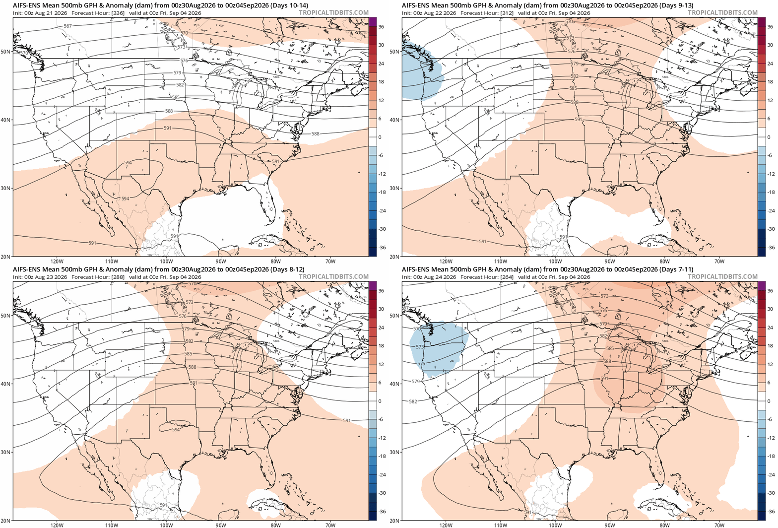
Euro and cm can have been showing the ridge/warmth potential for Aug 31 - labor day on several runs.
-
61F for the low. A bit disappointing. We hit that around 3 AM and started climbing. I guess, a bit of clouds and wind F'd us.
-

2026-2027 Record-breaking El Nino
GaWx replied to Stormchaserchuck1's topic in Weather Forecasting and Discussion
Based on model consensus suggesting higher than normal pressures at Tahiti likely dominating the 7 days or so, I don’t think the consistently strong -SOI dailies will return at least until early Sept. We could even have some +SOI dailies til then. -

2026-2027 Record-breaking El Nino
PhiEaglesfan712 replied to Stormchaserchuck1's topic in Weather Forecasting and Discussion
I was in the spa on Friday night, and my sister asked me why the spa doesn't stay consistently hot. It was at that moment that my understanding of the el nino/la nina cycle truly clicked. My answer was that it requires an extra amount of energy to maintain that heat. The same way that it requires extra heat to maintain an el nino. It was at that point that I realized why an el nino doesn't last, and ENSO neutrals/la ninas are more natural, lasting states. Then, she said that at hotels (where spas are maintained at continuous heat), there is a warning that you should not stay more than 15 minutes. It was at that point that I realized that if the earth was in a continuous el nino state, it would not really be habitable. (Like you'd have to leave the continuous warm spa after 15 minutes, you'd have to leave continuous earth to cool off after a certain period of time.) -

Augdewst 2026: Summer's Last Stand
Typhoon Tip replied to Prismshine Productions's topic in New England
Curious, what does Skynet think about the NAO during this time range above? -
for sure, TARP system still chewing through all the wastewater from the previous wet period and we're probably good on rain heading into the drier fall season the weather this time of year has been consistently wonderful, we're blessed
-
Augdewst 2026: Summer's Last Stand
Typhoon Tip replied to Prismshine Productions's topic in New England
Oh god, I'm gonna catch some bun blow back for this... but in 1995, we started getting hints and starts of -NAOs in late August, that more and then less continued into the autumn ...only to finally dominate from early November on. We started getting a local SE/Can to NE gradient look as the flow was carving a trough around the -NAO bias that month... Mixy snow and sleet to 2" remained in patches dappled about the UML commons by Veterans Day, and never actually completely disappeared before it was covered over by a more substantial snow mid month... Didn't see bare ground again until the mega thaw in late mid Jan - lost a 30 inch pack down to field ponds floating confused ducks. Winter made a decent comeback in Feb, but it wasn't as good. That's not likely happening this year and isn't intended as an analog - setting the table for making a point here. digressing.. anyway, the point of this was going to be that sometimes seasonal biases have roots in the immediate preceding season. Like you start seeing the biases early, albeit too subtle to perhaps notice the preponderance setting in. Until it becomes factored, sort of unknowable... Similar subject matter, active winters with coastal frequency/events, tend to see a autumn couple of coastals ... - the table sets while no one's looking. I'm only bringing it up because there's a significant correlation between warm ENSO's and the negative NAO mode - east vs west, notwithstanding. This is particularly true/more so in Jan/Feb. But I dunno ... if this thing does do the super duper phat dope badass whatever, maybe the dominating statistic punches thru earlier? -
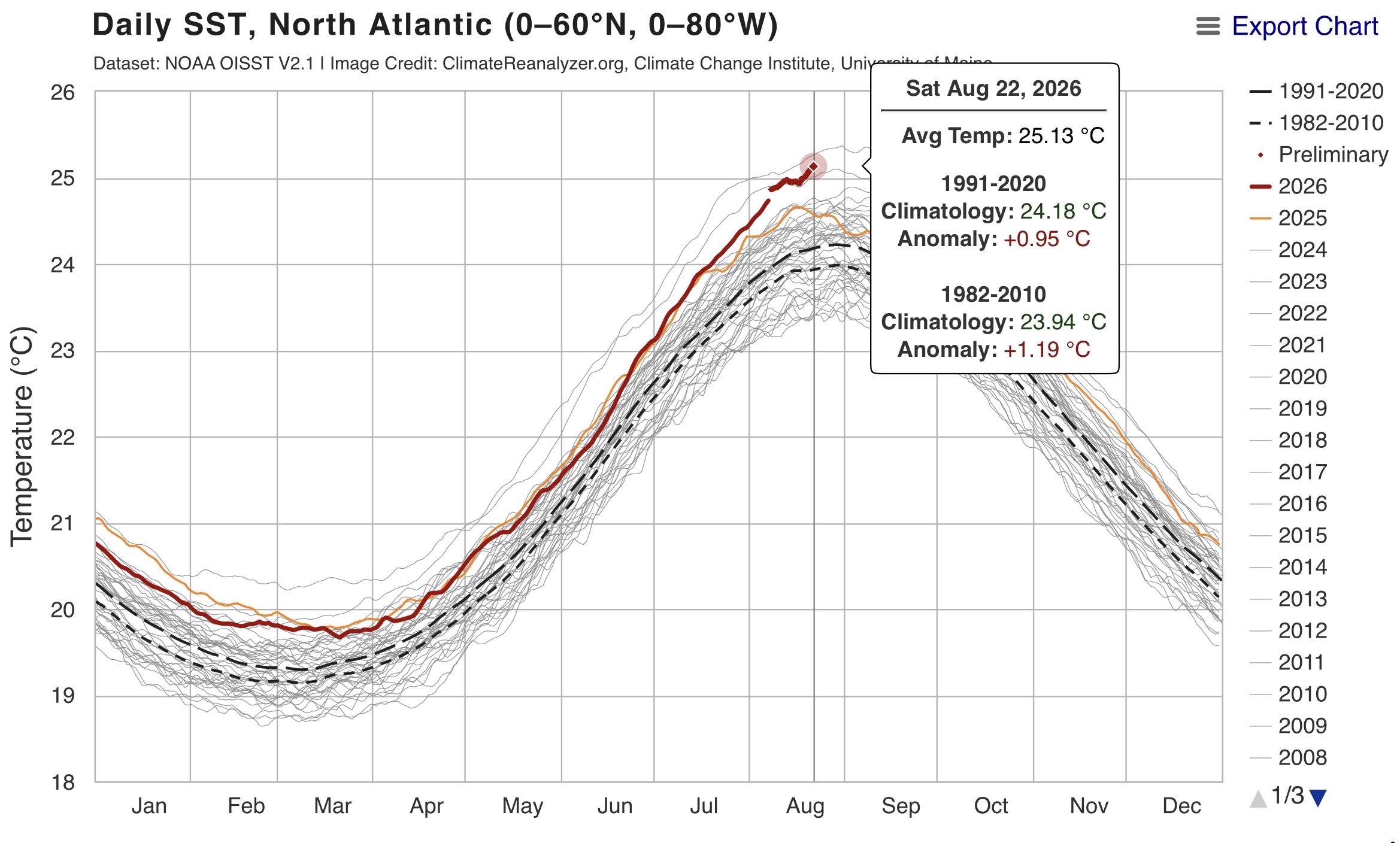
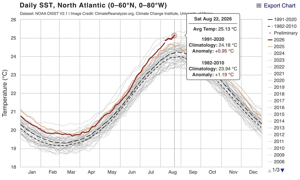
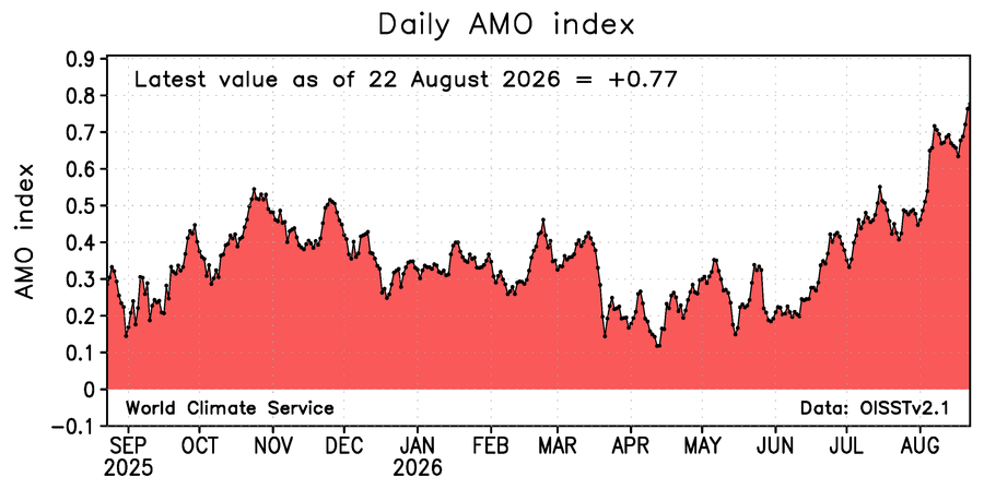
North Atlantic close to the all-time warmest set back in 2023.
-
warm and rainy
-

Augdewst 2026: Summer's Last Stand
forkyfork replied to Prismshine Productions's topic in New England
hello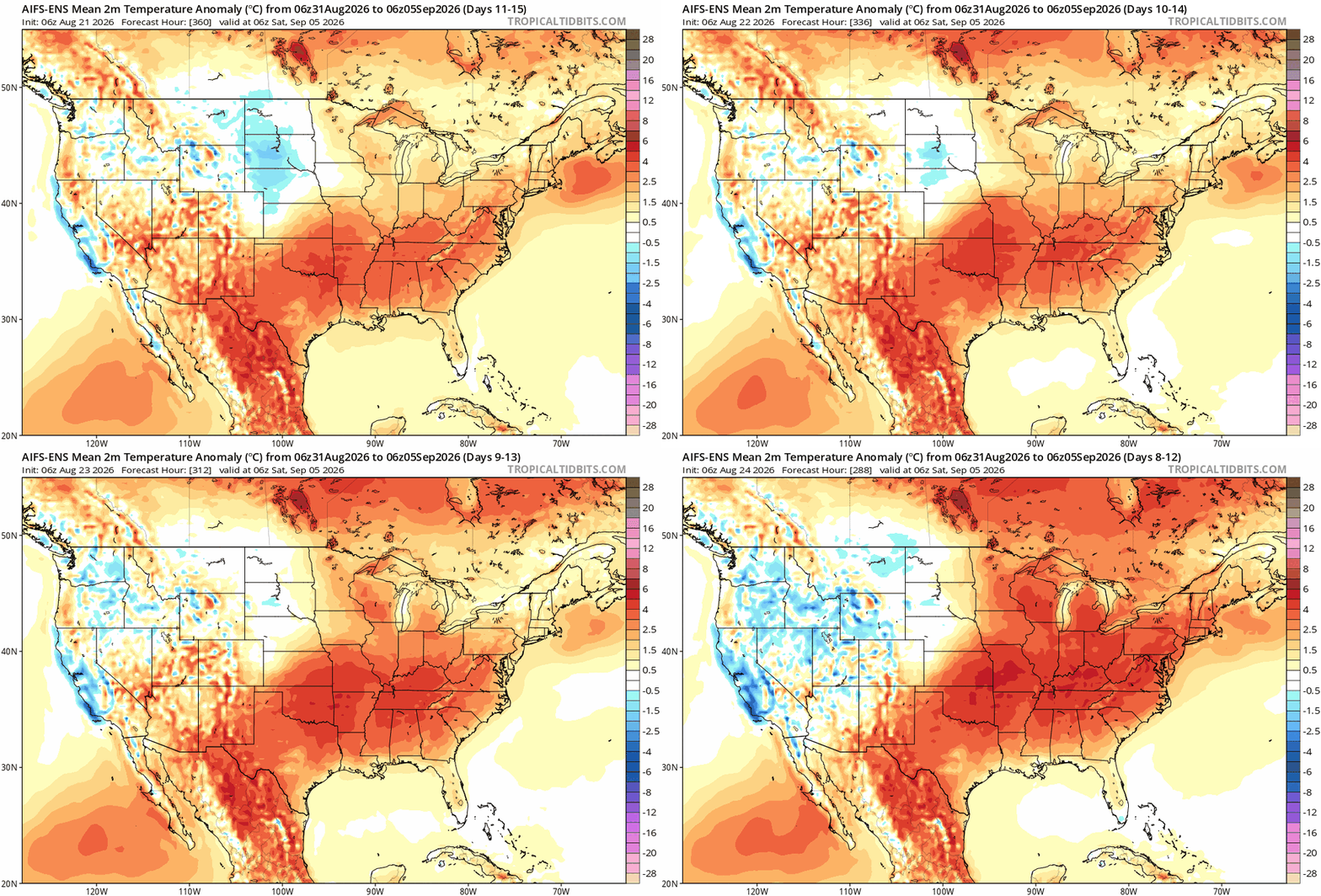
-
Nice crisp morning in the 50s here today ARR got down to 51 Rochelle 48!
-

2026-2027 Record-breaking El Nino
40/70 Benchmark replied to Stormchaserchuck1's topic in Weather Forecasting and Discussion
I like the MEI for coupling...I use the RONI more to gage how much MC influence there may be as a result of SST thermal distribution, but kind of related... -
A lil boredom never hurt. Personally I like these lulls. Makes you appreciate the action even more when it arrives. imo wall-wall action would get boring quick. Balance …. Just for perspective Chicago’s record for consecutive days with measurable precipitation is 11 days. 1880, 1949
-

2026-2027 Record-breaking El Nino
LakePaste25 replied to Stormchaserchuck1's topic in Weather Forecasting and Discussion
Yes. For record keeping purposes I will use absolute ONI however since that is always consistent with the 30 year mean, and RONI is too inconsistent in how it’s calculated between agencies and organizations. For atmospheric coupling purposes I will use RONI. 23-24 and 26-27 will likely get adjusted downward anyway until they become centered on their 30 year climate period. -
59.7 for the low and 5.33 for the month
-
2026-2027 Record-breaking El Nino
GaWx replied to Stormchaserchuck1's topic in Weather Forecasting and Discussion
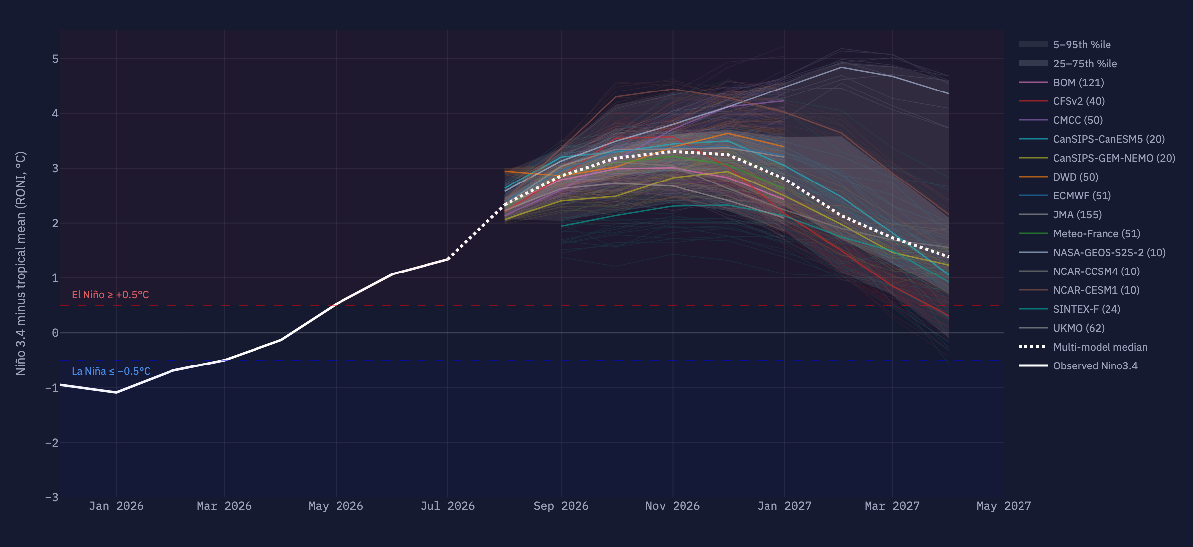
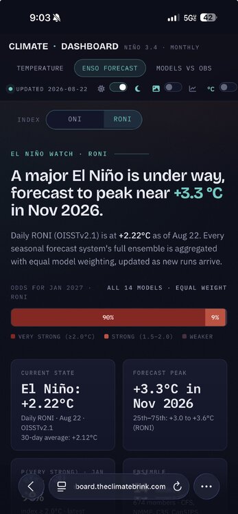
A daily peak of +3.3 on OISST seems reasonable to me as it would be consistent with a monthly peak of +3.0 and a trimonthly peak of +2.8. The dailies could even peak near +3.5 for that matter and still be consistent based on the volatility of the dailies. - Today
-
another missed ridge
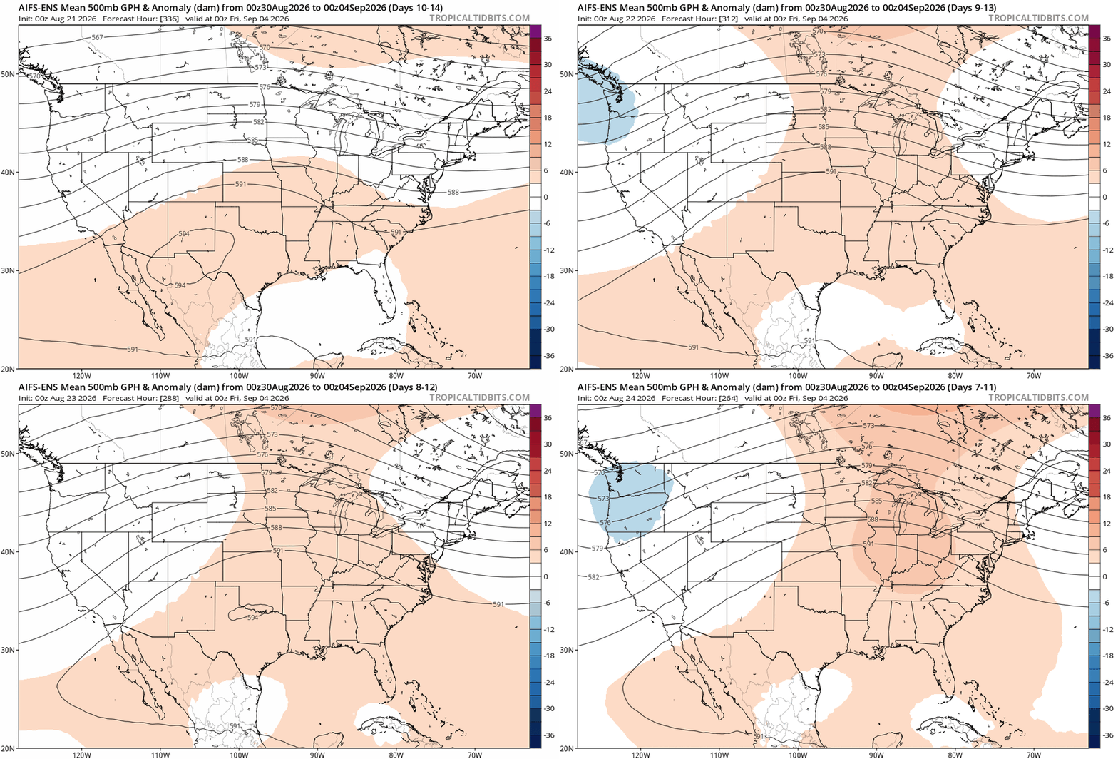
-
2026-2027 Record-breaking El Nino
LakePaste25 replied to Stormchaserchuck1's topic in Weather Forecasting and Discussion
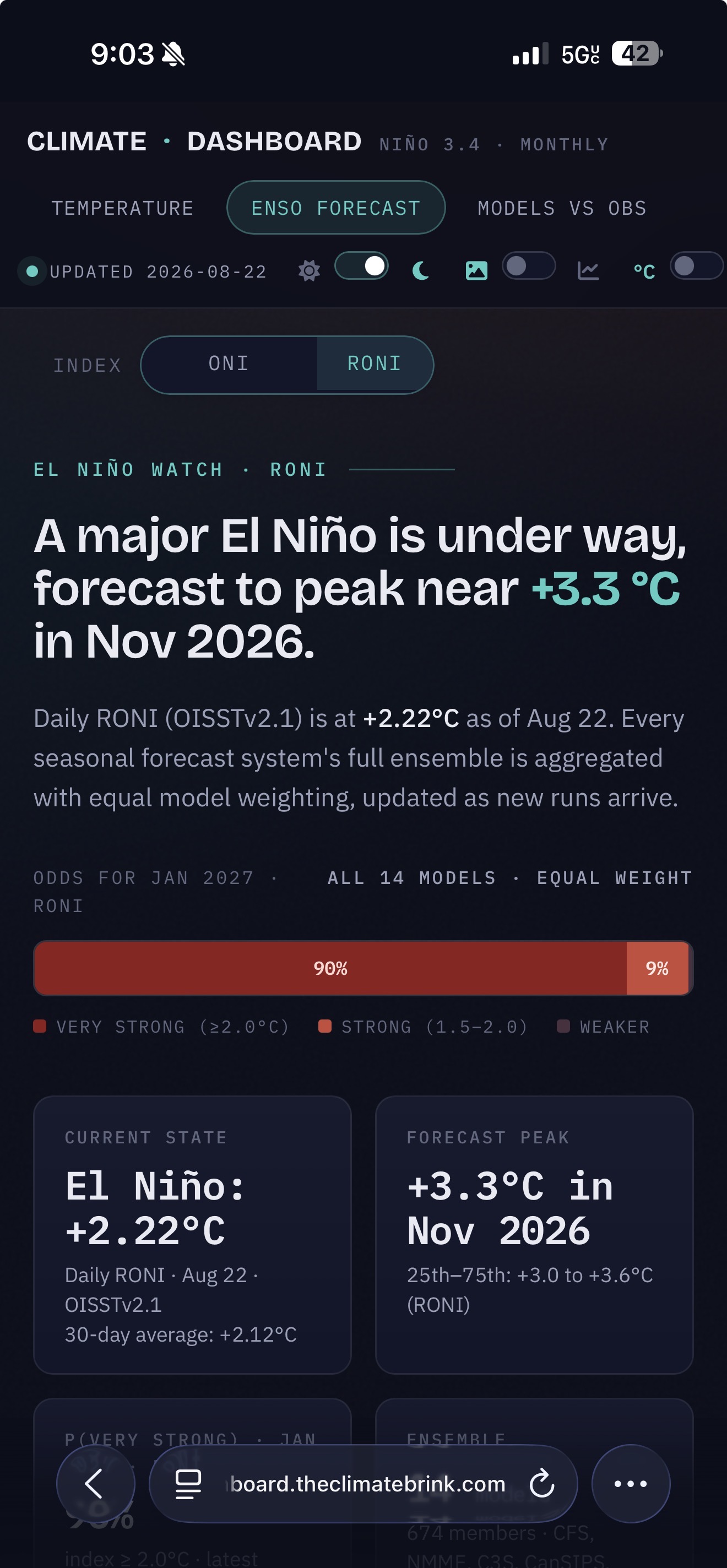
Climate dashboard is still going with a +3.3 RONI peak. This would be a daily peak and not trimonthly.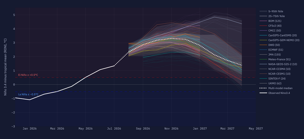
-
2026-2027 Record-breaking El Nino
40/70 Benchmark replied to Stormchaserchuck1's topic in Weather Forecasting and Discussion
Tri. -

Central PA Summer 2026 Discussion/Obs Thread
Mount Joy Snowman replied to Voyager's topic in Upstate New York/Pennsylvania
Low of 59 with .13” of rain. Mondays stink. -
Weekly update SST:
-
Augdewst 2026: Summer's Last Stand
40/70 Benchmark replied to Prismshine Productions's topic in New England
Yea, that fits...we've avoided the big heat, but def. not fall like.