All Activity
- Past hour
-
Is there a more drastic difference in sensible weather for a specific date one year apart here than 3/31 1997 and 1998?
-
Guy spent all day telling me it was going to be 40-45. Like taking candy from a weenie.
-
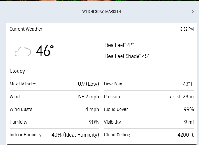
Yikes I'm only at 46
-
yeah thats intentional because the font for the climate sites i.e. PVD 37.9 overlaps with surrounding reports, same thing with all the other climate sites youll notice. So i delete them so it doesnt look bad and become hard to read/see.
-
It was a Saturday, 12:15 pm March 29, 1997 up at UML. Over the previous hour I had been looking over weather charts from Unisys internet site; the ECMWF and the MRF 12Z runs were updating ever couple of frantic mouse click moments. Over my shoulder, up upon the WX Lab monitor, the temperature read 63.3F ... despite what those model presentations were telling me. I recalled in the moment how an early week broadcast, Harvey Leonard was did his 20 second synoptic rundown before he gave us the numbers. He spoke in deference to "...A strong disturbance... closing off as it is crossing New York State.." He waved his hand in a rotational gesture and added, "...Should this vigorous feature manage to pass under Long Island, we'll be watching this for having much more important implications..." - may not be an exactly the words he used, but in after 30 years...but in principle. I remember that moment I sat there looking at those charts ... that was exactly what the 12z runs that morning were succeeding in doing. Moments later I walked across the University Ave bridge that spans the Merrimack in some of the most utopia sun drenched spring conditions physically make-able on planet Earth. It shown intensely through a random smattering of picturesque fair weather cumulus, leaning their shallow turrets south like the tipping masts of dinghy race. Lawns were already well green. And bumble bee bobbed temporarily by like something out of Disney. I thought about just how non suspectingly oblivious everything about that reality and the scene within it, were. I thought of this dichotomy memory because ... though there is no storm like coming, just the idea that it was that way it was, outside, just yesterday, and now it is 51 here with steaming streets under fervent spring sun, and knowing that 4.5" of snow followed by more glaze is due on deck ... it's amazing how we do this revolving door seasonality in spring around here.
-
Warmest in New England right now? Wow.
-
You want to lose power?
-
Arms hanging out the window heading north on 93.
-
I suppose it could. Part of the equation is rates/dynamics too. More dynamic may help with the sleet and snow in those areas that get it.
-
Sounds like you’ve been spending some time in Metheun .. burly beefy
-
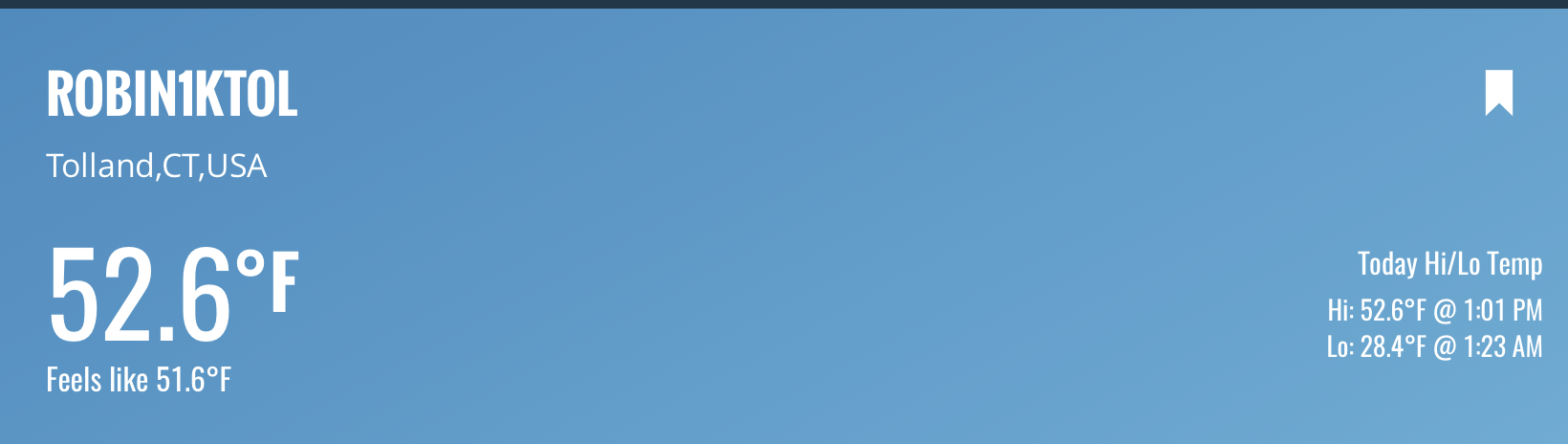
Stilll stuck at 37 in the valley…blech
-
49F as I cross the GWB….feels awesome out .
-
Pretty well summarize what I’ve been saying in that the northern jet which has been comfortably south of our region all winter now has a mean position right over our hood. It’s mid wintet north of it and mid spring south of it. Yesterday and today a perfect juxtaposition especially with no big storms and associated fronts, before, during or after….
-
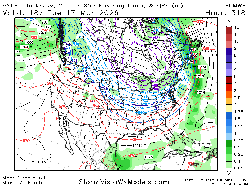
Euro has a huge cutter mid March which brings in cold air.

-
Euro has a huge cutter mid March which brings in cold air.
-
Well, we did it.
-
-AO for sure, NAO I'm not as concerned about. What would be helpful is a list of all 4"+ NYC March-April storms and which teleconnections were present to get a better idea of what you'd need for late season snow.
-
Any chance this trends colder as we approach go time? We now have a WWA for Hartford, Tolland and Windham counties
-
why?
-
Sounds like Kevin is out of the picture?
-
URGENT - WINTER WEATHER MESSAGE National Weather Service Boston/Norton MA 1218 PM EST Wed Mar 4 2026 CTZ003-004-MAZ002-004-008-009-012-026-050630- /O.NEW.KBOX.WW.Y.0013.260305T2200Z-260306T1700Z/ Tolland CT-Windham CT-Western Franklin MA-Northern Worcester MA- Western Hampshire MA-Western Hampden MA-Southern Worcester MA- Northern Middlesex MA- Including the cities of Putnam, Union, Charlemont, Chesterfield, Fitchburg, Milford, Willimantic, Blandford, Worcester, Barre, Ayer, and Vernon 1218 PM EST Wed Mar 4 2026 ...WINTER WEATHER ADVISORY IN EFFECT FROM 5 PM THURSDAY TO NOON EST FRIDAY... * WHAT...Mixed precipitation expected. Total snow and sleet accumulations up to two inches and ice accumulations between one-quarter to one-third of an inch. * WHERE...Interior high terrain of Southern New England. This includes the eastern slopes of the Berkshires, Worcester and northwest Middlesex Counties in Massachusetts, as well as Tolland and Windham Counties in Connecticut. * WHEN...From 5 PM Thursday to noon EST Friday. * IMPACTS...Travel could be very difficult, with tree and powerline damage possible. The hazardous conditions could impact the Thursday evening and Friday morning commutes.
-
We have this thing in my household where we call my 3 year old, Reed, "a big guy"...I always get him to laugh no matter how moody he is.....so everyone was musing about how "Reed is my favorite", and why...so my 6 yr old daughter out of nowhere comes up with "Is it because he's a big guy, and you like big guys"....I could not stop laughing She said it in the most innocent, straight forward, unassuming manner ever.
-
Agree with you. It’s all -WPO driven cold….with no mechanism downstream (Atlantic) and over the top (Arctic) to stop cutters and runners, that’s why you need -NAO/-AO blocking…to force secondary, coastal redevelopment. Color me very skeptical of some mid-late March I-95 corridor snow blitz with that look
-
55F - Torch
-

E PA/NJ/DE Spring 2026 Obs/Discussion
Birds~69 replied to PhiEaglesfan712's topic in Philadelphia Region
Damn Warm people creating new Spring threads too early! It's Winter damnit! We are not METS so continue winter! I'm glad it's in the 40s/drizzle and overcast and hope it continues! Hell, we only receive a solid 2-3 month of possible cold/cloudy/snowy winter weather per year so why are these idiots want to rush into Spring? June, July and August I understand but early March? F-that! Hope this spring is cold. miserable and damp!