All Activity
- Past hour
-
How to keep the Gulf of Alaska low from flooding pacific air into the NA continent. Pac jet pumps the Alaskan ridge into steroid range, and sends snow level cold to Florida.
-

Wounded Duck Strikes Back: Dec 26 & 27th Winter Storm Obs
40/70 Benchmark replied to WxWatcher007's topic in New England
It's cute how you list all of these meteorological milestones in areas where I do not reside, as if that will sway my opinion of my much it's sucked diseased donkey balls where I live. -

Ice Ice Baby December 28-29 Storm Discussion
dendrite replied to Baroclinic Zone's topic in New England
Monday’s morning commute may suck, but otherwise this is overblown. -
Wounded Duck Strikes Back: Dec 26 & 27th Winter Storm Obs
40/70 Benchmark replied to WxWatcher007's topic in New England
When you got boned in both "blockbusters", absolutely. I mentioned January 2024 because I didn't get boned in the January 7th event....I would also take December 2019, and February 2021. -
0z Euro....lol
-
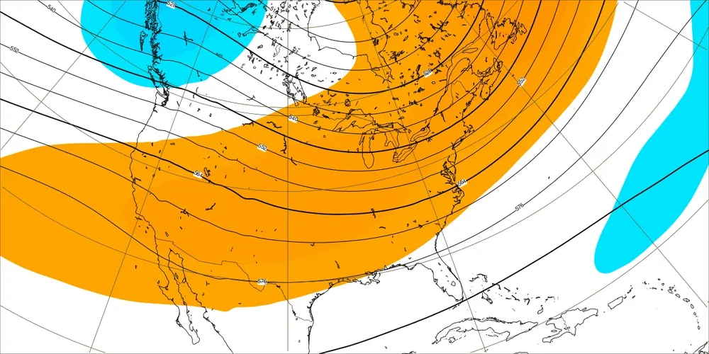
When you consider that both the EPS and GEFS have had a notable -PNA bias/notable warm bias from your area eastward and that all -ENSO -PNA Decs have transitioned to +PNA Jans, these consistently much better pattern maps for mid-Jan are quite encouraging. Just 5 days ago, the EW had this ugly (to me….for you not as bad) -PNA for 1/12-18:
-
All of a sudden, this looks like a pretty snowy few days starting on Monday in NE Ohio
-

Wounded Duck Strikes Back: Dec 26 & 27th Winter Storm Obs
vortex95 replied to WxWatcher007's topic in New England
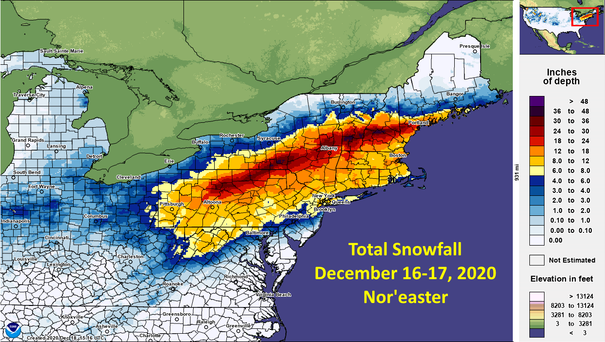
It's been lame I know, but just last 5 years, we have had two blockbusters than don't even come close to anything during the lame period 978-79 to 1991-92. I brought these up to CoastalWx recently. Dec 16-17, 2020 Snowfall map attached. 40"+ in a single snowstorm is rather rare in the Northeast and multiple reports. Sanbornton, NH: 42.4" - That is awfully close to the 24-hour snowfall record for the entire state of New Hampshire (49.3" atop Mount Washington, but that's almost cheating at over 6,000 feet). Binghamton, NY: 42.0" (40.0" at the official airport site) - That was good enough for the biggest snowstorm in the city's history! The old record was 35.3" in March of 2017. Binghamton averages about 82" in a full season, meaning they got about half in one day. Williamsport, PA: 24.7" - Another all-time record. And even more impressive, the city known for the Little League Baseball World Series only averages about 35" in an entire winter season. Alba, PA: 43.3" - This is currently under investigation and may end up as a new state of Pennsylvania 24-hour snowfall record. Ludlow, VT: 44.0" and Landgrove, VT: 42.0" - Both may have set new state Vermont 24-hour snowfall records. Jan 28-29, 2022 Snowfall map a attached. BOS 7th biggest snowstorm 24.3 tied record one day total 23.6" PVD 4th biggest snowstorms 19,3" biggest daily snowfall on record 18.8" Max amount 35.7" Bridgewater MA Do we forget so easy? Is an above avg snowfall season better than getting an isolated blockbuster in a below avg snowfall season? That's a matter of preference, but it not like we have lacked true KU classics during this current lame period. It's like the winter of 1996-97, well below avg snowfall for the season in much of southern New England, and then April Fools Blizzard made up for it being one of the most classic storms ever and brought my seasonal snowfall to almost exactly avg. Even CoastalWx I think will agree here!
-
As soon as I say suppression isn't an issue, the Euro has snow on the beaches.
-
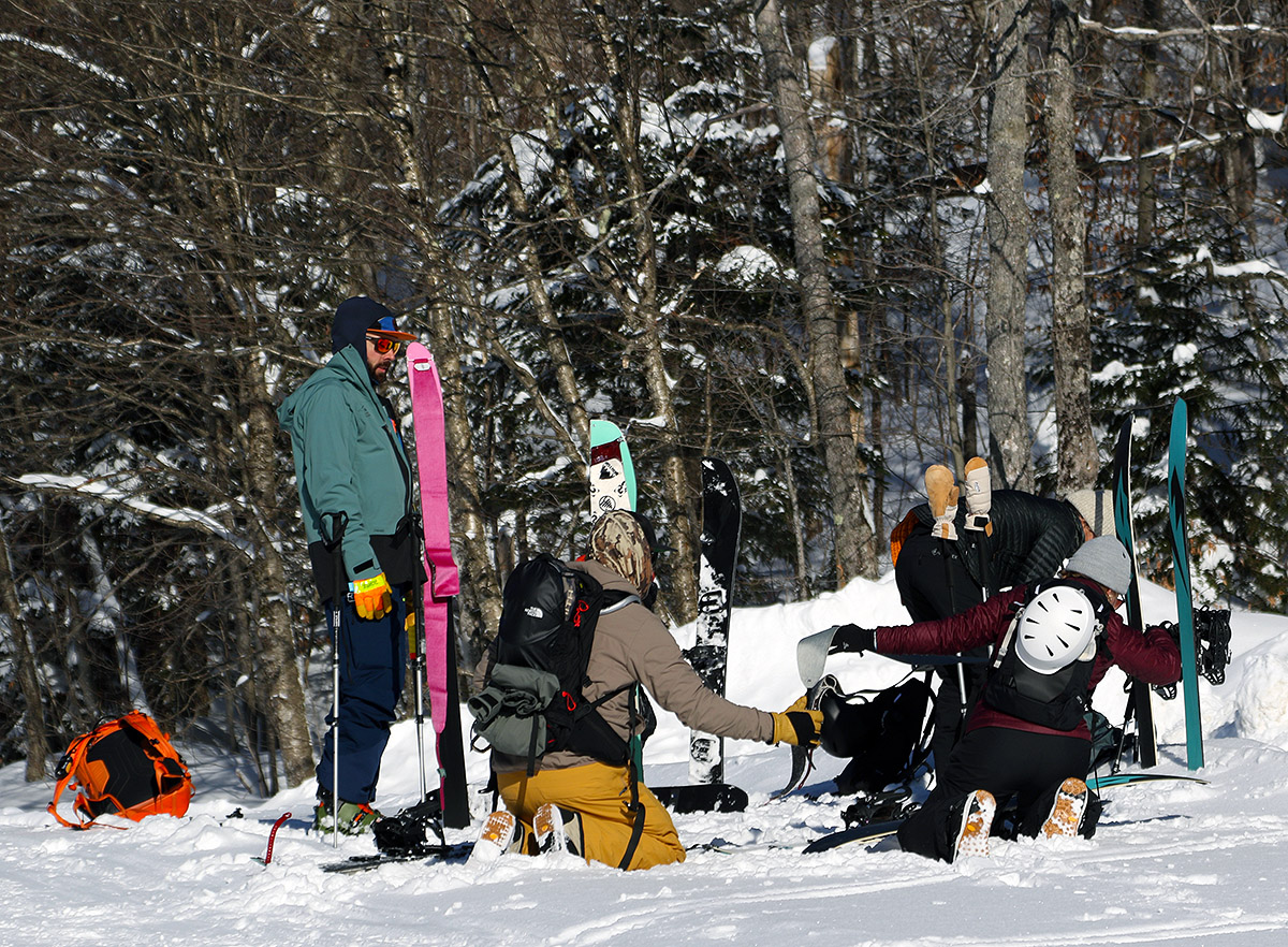
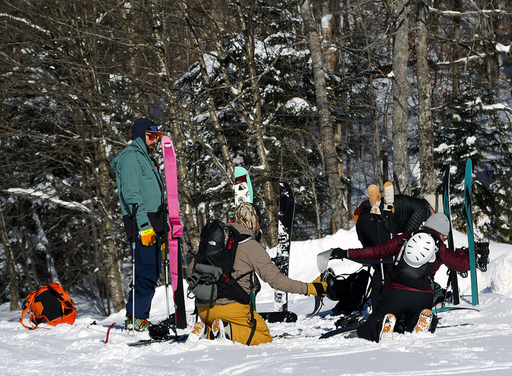
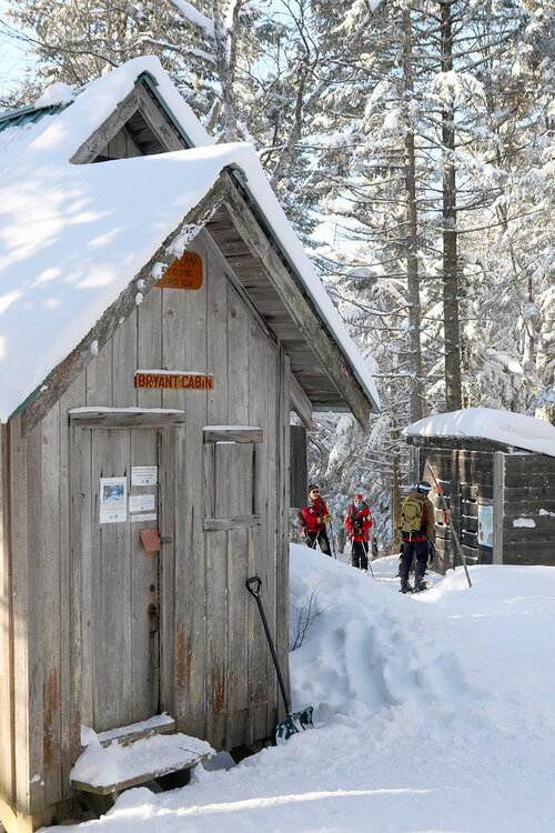
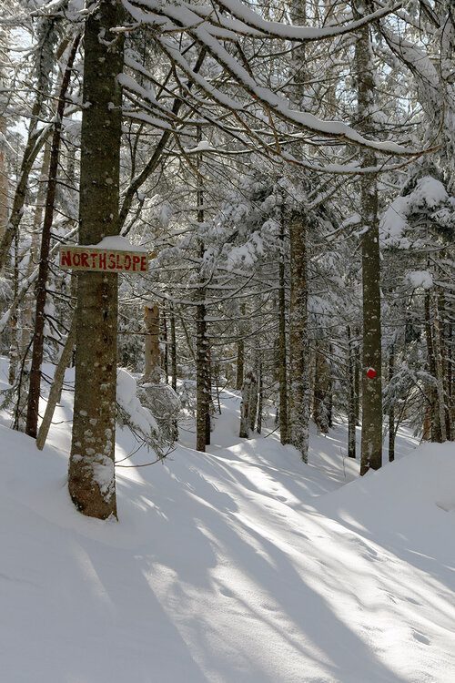
We were on the fringes of Winter Storm Devin up here in Northern Vermont, but Bolton Valley still picked up 3 inches of new snow from the system to top off the current powder depths. And thankfully, today was much warmer than yesterday – it was 15 F when I arrived in the Bolton Valley Village in the late morning period, which was quite a contrast from yesterday’s 2 F temperature at the start of my ski tour. Today I toured more on the eastern side of the Bolton Valley Nordic & Backcountry Network. I ascended the Bryant Trail up to and around the Bryant Cabin, then headed out on North Slope to catch some glades there with a descent via Gun Sight in the Gotham City area, and I finished off with some of the lower glades near the Telemark Practice Slope. The powder skiing continues to be absolutely fabulous, with the accumulations from Winter Storm Devin coming in around 6% H2O based off my snow analyses in the valley. That meant it topped off the current snow quite well and maintained the right-side-up density gradient in the powder. Between settling and compression from the new snow, total powder depths were about the same as what I encountered yesterday, with 12-15” around the 2,000’ level and 15-16” in the 2,500’-2,700’ elevation range. We’re definitely into the holiday week now, and with the great snow conditions, it’s not surprising that the resort is seeing a lot of visitors. Arriving in the late morning, they were already having people shuttle up from the Timberline parking lots, but thankfully some early morning folks were leaving at that point, and I was able to grab a spot in the second lot for backcountry/uphill skiers. The upper backcountry parking lot was actually blocked off for lessons, and while I was out on my tour I saw a couple of groups out with backcountry instructors, so it’s nice to see that people are taking advantage of the holiday week and the great powder conditions to get out there and become familiarized with backcountry skiing.
-
It was 86 degrees at my place today. I hope we can get some payback later into January. EPS weeklies definitely looking more promising mid month.
-
January 2026 regional war/obs/disco thread
40/70 Benchmark replied to Baroclinic Zone's topic in New England
I'll get excited when I'm up to my knees and shoveling without amounts half of everywhere around me. -
Wounded Duck Strikes Back: Dec 26 & 27th Winter Storm Obs
vortex95 replied to WxWatcher007's topic in New England
I was just going by climate sites for a first guess. CON is -2.4" for the season, but they are +0.5" for Dec, so only parts of srn NH. -
You should be excited about this upcoming pattern.
-
January 2026 regional war/obs/disco thread
40/70 Benchmark replied to Baroclinic Zone's topic in New England
Keep me updated -
Euro is very close with a big coastal at hours 240.
- Today
-
events up north need threads more often.
-
Wounded Duck Strikes Back: Dec 26 & 27th Winter Storm Obs
40/70 Benchmark replied to WxWatcher007's topic in New England
I think that is extended a bit too far to the north...MHT has like 14", which is at least normal for them....but I am not far se of them and only have 8". -
I'm not getting the blizz but was wide-eyed once I checked on my local, an inch of rain for just today then 8" of snow right on Monday! Enormous precip amounts! The roads are already icy from the freezing rain on Boxing Day - this is going to exacerbate the mess.
-
Wounded Duck Strikes Back: Dec 26 & 27th Winter Storm Obs
40/70 Benchmark replied to WxWatcher007's topic in New England
I don't give a rat's greasy taint about pond hockey...give me one huge storm surrounded by 50's, over cold and dry. It's easy to mock the IMBYism when you aren't in someone's shoes...it's been nearly a decade since I have sniffed a normal snowfall season. That is extraordinarily unusual and did NOT happen in the 80s. -
Wounded Duck Strikes Back: Dec 26 & 27th Winter Storm Obs
40/70 Benchmark replied to WxWatcher007's topic in New England
Yea, another sucky month in terms of snow AFAIC......only reason it isn't abysmal is the 3" right before XMAS. But I'm not sure how you consider it a good winter month when your largest storm is 3". I'd take January 2024 over December 2025 100/100 times. -
Brutal stuff..not even our borderline feral cat wants to go out in this nut shrinking airmass. Great day and night to embrace the spirit of the season, hibernation!
-
Another December in the books without a legit snowfall around these parts. Zzzzz decembers becoming the norm.
-

December 2025 regional war/obs/disco thread
OrangeCTWX replied to Torch Tiger's topic in New England
I’m currently in Newport for the weekend lol I’m seeing 22F as the current temp. Regardless legit dont think I’ve ever been here with snow on the ground. Shows how cold the last storm was for all of SNE. -
Wounded Duck Strikes Back: Dec 26 & 27th Winter Storm Obs
40/70 Benchmark replied to WxWatcher007's topic in New England
Thanks for mentioning....I noticed that that actually made my map look worse if extrapolating it out haha.