All Activity
- Past hour
-
Looks pretty set that through around new years the east is going to be NN to AN and the only source of cold would be a sneaky high building in from New England (would get us cold enough so that people laugh at those calling for a torch but not actually provide winter weather shots). NAO now looks to stay slightly negative or neutral, so not much of a factor. PNA is going to stay deeply negative. I hope this is a reset and not a new base state for this winter. This would require an active STJ and with the pacific raging that isn’t going to happen. I get it with NAO going neutral to slightly negative and ridge building over the Midwest, so we’ll have back door fronts and wedge opportunities, but there isn’t any moisture. Dry and near normal through new years would be the best forecast call for the region. Probably a few AN days thrown in
-

December 2025 regional war/obs/disco thread
Damage In Tolland replied to Torch Tiger's topic in New England
-
Fell to 15.6 just after midnight, then a very slow climb to 17.5 at 7 am CoCoRaHS report, 11 degrees warmer than yesterday.
-

December 2025 regional war/obs/disco thread
40/70 Benchmark replied to Torch Tiger's topic in New England
Exceedingly rare. -

December 2025 regional war/obs/disco thread
Ginx snewx replied to Torch Tiger's topic in New England
Prolific overunning can be a major snow. -
2025-2026 ENSO
40/70 Benchmark replied to 40/70 Benchmark's topic in Weather Forecasting and Discussion
I would take 1996 and run relative to what I have had recently...December was nice, and had an early April event for the ages. -
December 2025 regional war/obs/disco thread
Ginx snewx replied to Torch Tiger's topic in New England
-

Central PA Winter 25/26 Discussion and Obs
mahantango#1 replied to MAG5035's topic in Upstate New York/Pennsylvania
When the next threat of winter precip.? -

Central PA Winter 25/26 Discussion and Obs
Blizzard of 93 replied to MAG5035's topic in Upstate New York/Pennsylvania
Low in Marysville this morning was 7, which is coldest of the season here. -
Low of 25.0 actually occurred before midnight, then temps rose to 31.7 before dropping in the last hour to 29.9. Clouds and wind likely contributed to the temp spikes through the night as evidenced by RDU observations
-

Central PA Winter 25/26 Discussion and Obs
CASH_COOP replied to MAG5035's topic in Upstate New York/Pennsylvania
Impressive for the airport. I had 5 coldest so far dis season -
December 2025 regional war/obs/disco thread
40/70 Benchmark replied to Torch Tiger's topic in New England
It does suck, I agree. But it could be worse and we have certainly seen worse this time of year.. I wouldn't be surprised if most of us had an inch or two on the ground for xmas. That said, this is not the pattern for a major snow...completely agree. -
Last night's Euro and EPS went back to warm/torch
-
December 2025 regional war/obs/disco thread
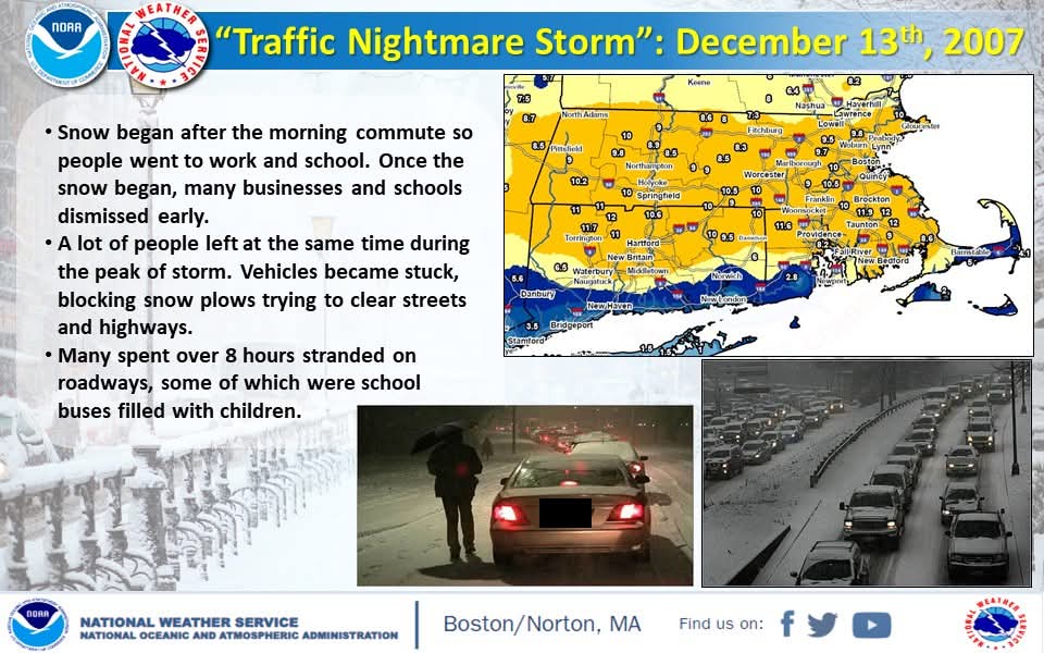
40/70 Benchmark replied to Torch Tiger's topic in New England
Yea, that was a few days before my favorite one on 12/16/07. -
December 2025 regional war/obs/disco thread
Ginx snewx replied to Torch Tiger's topic in New England
-
Euro with 978 mb in southern Ottawa. 61 is record high for the date here. They will be under threat regionally Should be taking notes that all of our big storms have been cutters. From someone who only wants big snowstorms, and seasonal cold. This is pattern is trash.
-
December 2025 regional war/obs/disco thread
40/70 Benchmark replied to Torch Tiger's topic in New England
Spoken from the guy that doesn't have 4 under the age of 7 -
December 2025 regional war/obs/disco thread
Damage In Tolland replied to Torch Tiger's topic in New England
I think most would root for and welcome that scenario -
Hopefully the grid is taken down Christmas morning and kids are left with no power for a week.
-
If it isn't going to snow, 40's and 50's are fine with me. Atleast it's warm enough to go outside to get away from family when needed.
-
December 2025 regional war/obs/disco thread
Ginx snewx replied to Torch Tiger's topic in New England
Absolutely. Models insist on temps being cold all the way up. Go Skynet! -
Through the 15th / first half of Dec Departure LGA: -8.6 NYC: -8.6 EWR: -7.9 JFK: - 7.6
-
Long range is so flat we can't even stamp a laugh, or weenie emoji on anyone's posts.
-
Records: Highs: EWR: 65 (2021) NYC: 63 (1971) LGA: 63 (2021) JFK: 65 (1971) Lows: EWR: 10 (1942) NYC: 7 (1876) LGA: 13 (1951) JFK: 15 (1961) Historical: 1811: The area around New Madrid, MO was rocked by a powerful earthquake estimated at a magnitude 8.0 or greater on the Richter Scale. It was the first in a series of tremors during the winter of 1811-1812 that would become known as the worst series of earthquakes in U.S. history at this time. For a time the Mississippi River actually ran backwards. Church bells as far away as Charleston, SC and Washington, DC were rung by the tremors, which were felt over a land area of almost one million square miles. (Ref. AccWeather Weather History) 1835 - New England experienced one of their coldest days of record. At noon on that bitterly cold Wednesday the mercury stood at four degrees below at Boston, 15 degrees below at Norfolk CT, and 17 degrees below at Hanover NH. The temperature at Boston was 12 degrees below zero by sunset. Gale force winds accompanied the severe cold, and that night a great New York City fire destroyed much of the financial district. (David Ludlum) 1890: A big snowstorm began over Pittsburgh, PA on this day and continued into the 17th. 23.9 inches of snow fell in 24 hours, their greatest 24 hour snowfall on record for the city. (Ref. AccWeather Weather History) 1896: Violent northeast gales and snow hit the Boston, Massachusetts area. (Ref. NOAA Boston Weather Events) 1917: An ice jam closed the Ohio River between Warsaw KY and Rising Sun IN. The thirty foot high ice jam held for 58 days, and backed up the river a distance of 100 miles.(David Ludlum) 1917 - An ice jam closed the Ohio River between Warsaw, KY, and Rising Sun, IN. The thirty foot high ice jam held for 58 days, and backed up the river a distance of 100 miles. (David Ludlum) 1941: The U.S. Weather Bureau suspended nationwide weather reports as a result of the attack on Pearl Harbor. (Ref. Wilson Wx. History) 1945: Lake effect snow squalls buried Buffalo, NY under 24.3 inches of snow in 24 hours. (Ref. Wilson Wx. History) 1965: The latest first measurable snowfall in Chicago was recorded on this date in 1965. Snow Trivia for Chicago - NWS 1973: Central Connecticut was crippled by a major ice storm, which knocked out power for days and downed more trees than the New England Hurricane of 1938. Boston, MA had their latest seasonal recorded trace of snow. (Ref. AccWeather Weather History) 1987 - A Pacific storm battered the coast of California with rain and high winds, and dumped heavy snow on the mountains of California. Winds along the coast gusted to 70 mph at Point Arguello, and winds in the Tehachapi Mountains of southern California gusted to 100 mph at Wheeler Ridge. Snowfall totals ranged up to 24 inches at Mammoth Mountain. Snow fell for two minutes at Malibu Beach, and Disneyland was closed due to the weather for only the second time in twenty-four years. A winter storm which began in the Southern Rockies four days earlier finished its course producing snow and high winds in New England. Snowfall totals ranged up to 19 inches at Blanchard ME. (The National Weather Summary) (Storm Data) 1988 - Fairbanks, AK, reported freezing rain and record warm temperatures. The afternoon high of 41 degrees was 43 degrees above normal. Snow and high winds continued to plague the mountains of southern California. Mount Wilson CA reported two inches of rain in six hours during the early morning, and a storm total of more than 3.50 inches of rain. (The National Weather Summary) 1989 - Fifty-seven cities from the Southern and Central Plains to the Appalachians reported record low temperatures for the date, including North Platte NE with a reading of 17 degrees below zero. Squalls in the Great Lakes Region produced 18 inches of snow at Syracuse NY, and 30 inches at Carlisle IND. Low pressure brought heavy snow to northern New England, with 18 inches reported at Derby VT and Saint Johnsbury VT. (The National Weather Summary) (Storm Data) 2000 - An F4 tornado hits communities near Tuscaloosa, AL, killing 11 people and injuring 125 others. It was the strongest December tornado in Alabama since 1950.
-
(002).thumb.png.6e3d9d46bca5fe41aab7a74871dd8af8.png)
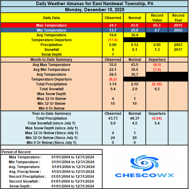
Central PA Winter 25/26 Discussion and Obs
ChescoWx replied to MAG5035's topic in Upstate New York/Pennsylvania
We had quite a few spots with lows in the single digits. The lowest was the 3.8 degrees at Warwick Township. The sun returns today and we should see some melting of the snow but with high temperatures remaining below freezing and the low sun angle it will be limited. Our much colder than normal December continues before we finally warm up to above normal on Thursday and Friday with rain arriving on Thursday night. Expect some fog over the melting snow with this system and most of the snow cover will be gone by Friday morning. Rain amounts could approach an inch in some spots. Looking ahead to Christmas week temperatures look to be not too far from normal for Christmas, but chances of a White Christmas look slim.