All Activity
- Past hour
-
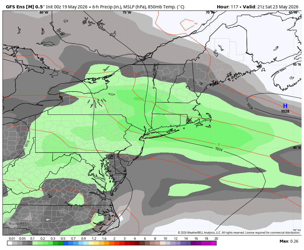
The CAMs were wrong about everything getting stuck in Missouri and nothing getting up here. There were no strong storms around here, so in that regard the weekend was a dud. However, another round of solid rain dropped 0.64" in my yard overnight. Four decent rounds of rain through the weekend added up to 1.86". The rest of the month is looking drier and fairly boring again.
-
Looks like we get storms here today if the NAM is right.. plus with what we had last week and what coming this weekend all of us should be good
-
Front might be a bit too fast.
-
HRRR literally has no storms tomorrow . Will be tough to come out of this 5 day heater with no rain
-
I did not . 40’s and rain thru weekend?
-
Yeah, best weather this weekend is north and east. Seems like Saturday and part of Sunday maybe we can salvage down here.
-
GWDLT Saturday?
-
Did you look at 6z?
-

Central PA Spring 2026 Discussion/Obs Thread
mahantango#1 replied to Voyager's topic in Upstate New York/Pennsylvania
We'll take it one day at a time. -

Central PA Spring 2026 Discussion/Obs Thread
pawatch replied to Voyager's topic in Upstate New York/Pennsylvania
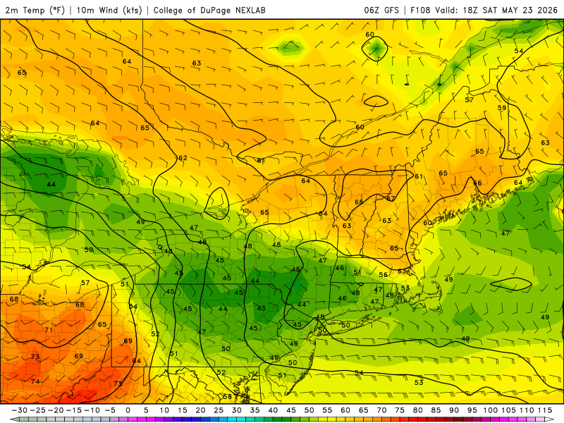
Montourville recorded a high of 94 yesterday. “Airport NWS” Didn't break a record…record 95 degrees set 1962. Garden view where I live, we had 95-96 depending what thermometers I go off of. We also had a lot of thunder and lightning in the area from 10:30 pm to 1:30 pm. One heck of a lightning storm, but very little rain. rainfall total for me .02” someone got hit? -
That’s not the op
-
It is? Here's the GFS.

-

2026-2027 Strong/Super El Nino
40/70 Benchmark replied to Stormchaserchuck1's topic in Weather Forecasting and Discussion
I think keying in on major signals when developing an analog composite does have some value. -

Central PA Spring 2026 Discussion/Obs Thread
Voyager replied to Voyager's topic in Upstate New York/Pennsylvania
Indeed... But...it's hard to get excited about the summer like weather when the forecast high for Saturday drops all the way down to 58 with mid 40's lows again. -
2026-2027 Strong/Super El Nino
40/70 Benchmark replied to Stormchaserchuck1's topic in Weather Forecasting and Discussion
I def. wouldn't be as worried about it where you are....more wiggle room. -

E PA/NJ/DE Spring 2026 Obs/Discussion
Hurricane Agnes replied to PhiEaglesfan712's topic in Philadelphia Region
After a 67 low yesterday, I hit 95 for a high just before 3 pm. Another scorcher today with my low so far a little with my low of 71 so far about 4 degrees warmer than yesterday. Currently sunny and 72 with dp 69. - Today
-

Central PA Spring 2026 Discussion/Obs Thread
Mount Joy Snowman replied to Voyager's topic in Upstate New York/Pennsylvania
68 at the house, 64 through the rurals. Looks like MDT topped out at 93 yesterday. Can we go record chasing today? Quite the unsettled period coming up it appears. -
Alll the AI’s and GFS suppress it all south . Euro is still showery . We’ll see
-
Is the weekend doneski bunky you think?
-
LWX doesn't seem to be buying it
-
It’s now Euro vs world for the weekend
-
What a furnaced airmass. My low is 68. It was 71 at almost 4:00 am
-
Highs approaching the May monthly max in NJ today. Time Series Summary for NEWARK LIBERTY INTL AP, NJ - Month of May Highest Monthly Maximum Temperature Click column heading to sort ascending, click again to sort descending. 1 1996 99 0 2 2022 98 0 - 1992 98 0 - 1987 98 0 - 1962 98 0 3 1965 97 0 - 1895 97 0 4 2021 96 0 - 2016 96 0 - 1969 96 0 - 1964 96 0 - 1914 96 0 - 1880 96 0 5 2010 95 0 - 1994 95 0 - 1986 95 0 - 1941 95 0 - 1939 95 0 Monthly Data for May 1996 for New Jersey Click column heading to sort ascending, click again to sort descending. PENNSAUKEN 1N COOP 100 NEWARK LIBERTY INTL AP WBAN 99 Newark Area ThreadEx 99 TOMS RIVER COOP 99 PHILADELPHIA/MT. HOLLY WFO COOP 98 PEMBERTON COOP 98 PLAINFIELD COOP 97 INDIAN MILLS 2 W COOP 97 CRANFORD COOP 96 JERSEY CITY COOP 96 PHILLIPSBURG-EASTON BRIDGE COOP 96 TETERBORO AIRPORT WBAN 96 LITTLE FALLS COOP 96 WAYNE COOP 96 WANAQUE RAYMOND DAM COOP 96 HARRISON COOP 96 Atlantic City Area ThreadEx 96 BELLEPLAIN STA FOREST COOP 96 ATLANTIC CITY INTL AP WBAN 96 WOODSTOWN PITTSGROV 4E COOP 96 MOORESTOWN 4 E COOP 96 Monthly Data for May 2022 for New Jersey Click column heading to sort ascending, click again to sort descending. NEWARK LIBERTY INTL AP WBAN 98 TETERBORO AIRPORT WBAN 98 Newark Area ThreadEx 98 ESTELL MANOR COOP 96 HARRISON COOP 96 SOUTH JERSEY REGIONAL AIRPORT WBAN 96 ATLANTIC CITY INTL AP WBAN 95 INDIAN MILLS 2 W COOP 95 CALDWELL ESSEX COUNTY AP WBAN 95 AEROFLEX-ANDOVER AIRPORT WBAN 95 SOMERSET AIRPORT WBAN 95 EB FORSYTHE NEW JERSEY RAWS 95 Atlantic City Area ThreadEx 95
-
Central PA Spring 2026 Discussion/Obs Thread
mahantango#1 replied to Voyager's topic in Upstate New York/Pennsylvania
-
Central PA Spring 2026 Discussion/Obs Thread
mahantango#1 replied to Voyager's topic in Upstate New York/Pennsylvania
A well earned high at that!