All Activity
- Past hour
-
Lock in CEF/Holyoke flood.
-
Could be those pulse type with lots of CGs and probably even some of those nasty +CGs.
-
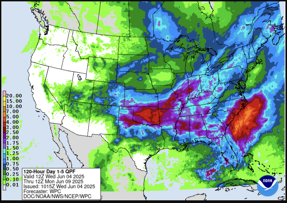
exc Except that the NAM's grid indicates a convective induced frontal sag through the region with under cutting N-NE cooled air... It's all probably just NAM fantasy at this range, but if suppose it had legs ... it's pretty clear in the FOUS that day's SB CAPE is shit smeared. It's also now losing the low transit through NNE so it's going after Saturday too.
-
I'm really hoping to get something out of this...even if non-severe. I am off this week and next week for my friend and I's annual get together for local chasing. One of these years we'll do out west but my energy levels are fading and I'm so tired of driving so who knows
-
I see what Wizzy is seeing on the NAM. There is a psuedo EML tickling S coast and decent CAPE near and SoP. Despite limited shear, forcing looks to be along wavering from near pike. So yeah...a few storms could be interesting.
-
Heat comes right back for sweaty COC.
-
Assuming the 12z GFS is correct. A big assumption right now - but that has a great look for strong/severe Sunday afternoon.
-

2025-2026 ENSO
40/70 Benchmark replied to 40/70 Benchmark's topic in Weather Forecasting and Discussion
You mean the QBO is oscillating back and forth from westerly to easterly...must be CC!! JK -
Red hot news bulletin (followup): Not at all surprisingly based on past patterns, the 30 mb QBO dropped to negative in May (-4.59) from April’s +6.94: https://psl.noaa.gov/data/correlation/qbo.data
-
 Your problem is you have zero proof any of those moves required a 2 to 4 degree temperature adjustment which is what took place. As a simple example (small sample size but enough to be clearly directional) I have analyzed the difference between the relatively rural Coatesville 2W at 660 ft ASL vs Thorndale 290 feet above sea level and in the middle of a sprawling development but only a few nautical miles apart. Even a move from the relatively rural Coatesville 2W to an suburban sprawl development at almost 400 ft asl lower does not result in anywhere close to the magnitude of changes the NCEI tries to apply.
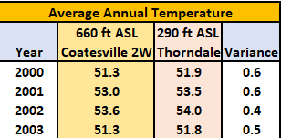
-
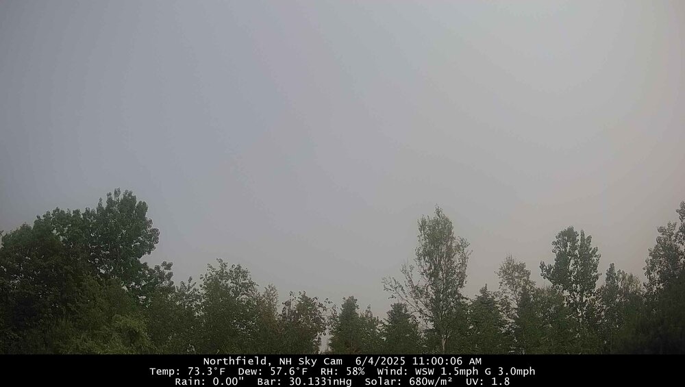
hi res vis imagery has the "back edge" of this smoke band about 10 minutes up 89 from CON and collapsing SE...
-
That's very quick burst of heat then 70s low 80s. Welcome to coc season
-
2025-2026 ENSO
40/70 Benchmark replied to 40/70 Benchmark's topic in Weather Forecasting and Discussion
The 1960s being much colder than the 2010s is definitely attributable to a combo of both CC and the AMO (- vs +). -
2025-2026 ENSO
40/70 Benchmark replied to 40/70 Benchmark's topic in Weather Forecasting and Discussion
One thing I will say is that the 2015-2016 winter was much milder and less wintry overall, aside from the mid atl blizzard, then the 1957-1958 el nino....I am sure CC plays a role there maybe, but the former event was also simply stronger, too. Again, possibly due to CC.....that is reasonable. -
Love this deep summer look and feel! 80 on car thermometer in Hampton.
-
2025-2026 ENSO
40/70 Benchmark replied to 40/70 Benchmark's topic in Weather Forecasting and Discussion
Exactly...I agree, but listen...maybe Chris is right...I am willing to wait and see and I will change my mind if we are still sporting a negtive PDO in 7-10 years. But I don't see why the default baseline should be some radical change to the global circulation and multidecadal patterns. The climate/meteorology community should remain open to that possibility as scientists, but it should not be assumed at this juncture given the info that I have just presented. -
I still say that the predominantly +3/2014-7/2016 during El Niño is similar to 6/1957-2/1959.
-
to 78 (add 10) gets to 88 for here. Smoke mainly cleared through Jersey. Hot spots look low 90s tomorrow
-
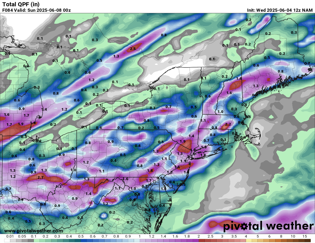
Looks like widespread half inch on Saturday
-
Now this is the weather I need.
-
Hazy shade of summer
-
Then we have the nam

-
Code Orange in effect today with the worst of the haze/smoke expected east of the Susky. I see little evidence of it here at work currently, however.
-
- Today
-
flipped back to ireland mode today, guess we need the rain def the greenest drought i can remember