All Activity
- Past hour
-
We need blocking. These NS waves are cute for a day or two, but this area needs a region-wide snowstorm with overrunning moisture from the south on top of a slow moving, dense dome of arctic air blocked by a downstream traffic jam.
-

December 2025 regional war/obs/disco thread
Typhoon Tip replied to Torch Tiger's topic in New England
I bet a marginal goes up for us on Friday... wouldn't be shocked. -

December 2025 regional war/obs/disco thread
weatherwiz replied to Torch Tiger's topic in New England
Yeah I agree, I definitely would like to start getting some bigger systems, but if we can pull off a good two week stretch where we get 3-4 systems in the 2-4" range...I would hope that makes everyone a bit happier lol. -
I actually get the occasional blizzard dream and we are due. I might regret selling my jeep in a month or two.
-
While the longwave pattern is kind of ugly (and it’s an unstable look), the shear number of shortwaves flying through the flow will give us some chances. So while the probability of any one of these succeeding in being a 4”+ snow event is pretty low, if we have several chances, maybe one of them delivers. Most of us would be fine with a couple inches that gets us to Christmas but once the holiday has passed, I want some bigger systems.
-
melting pretty good here with some sun and temps at 42
-
-

December 2025 regional war/obs/disco thread
WxWatcher007 replied to Torch Tiger's topic in New England
I’d rather ride the line here than be in Missouri with no hope. -
There’s a 100% chance of something and a 0% chance that anyone knows with 100% certainty.
-
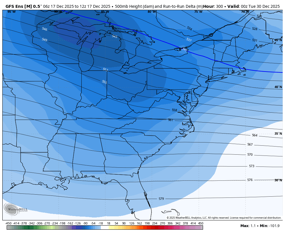
Check out the widespread much lower H5 for nearly the entire E US on the 12Z GEFS vs the 6Z GEFS as of 0Z 12/30 helped mainly by the apparently even stronger -NAO:

-
Avalanches of snow sliding off the solar panels. Its wild
-
December 2025 regional war/obs/disco thread
weatherwiz replied to Torch Tiger's topic in New England
The 27-29 period looks like it could be interesting -
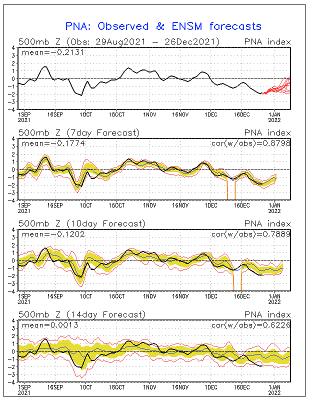
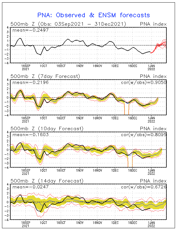
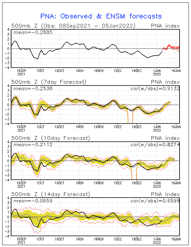
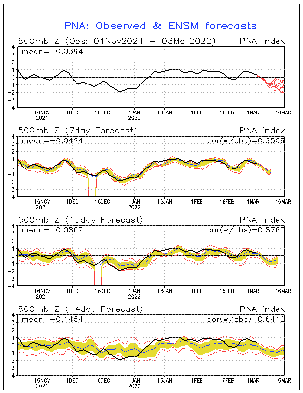
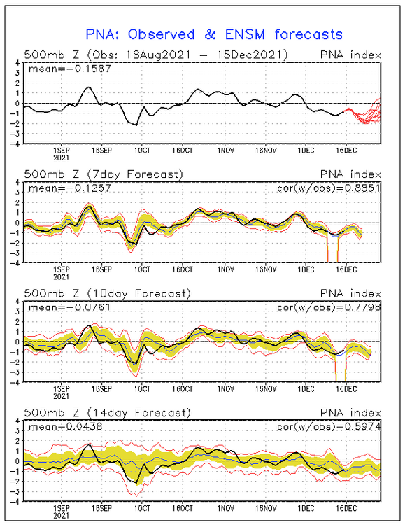
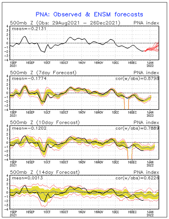
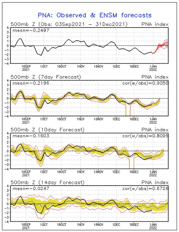
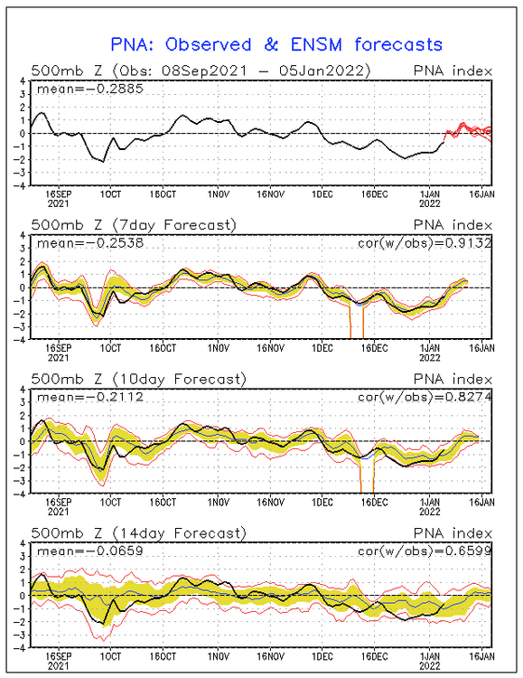
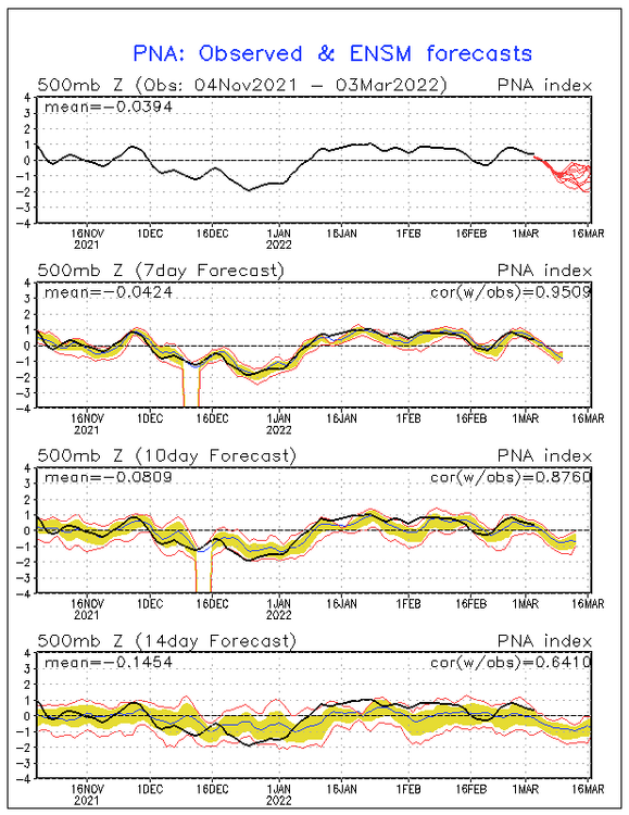
These images show that the GEFS was too slow in showing the transition from the very strong -PNA of Dec 2021 to the strong +PNA of Jan of 2022: 12/15/21 GEFS PNA forecast was ok But the 12/26/21 GEFS PNA forecast, which goes through 1/9/22, had all members 0 to -2 for then. The actual 1/9/22 ended up being +0.2. So, it was too slow in predicting the turn to a +PNA: 12/31/21 GEFS PNA forecast out to 1/14/22: finally turned to +PNA but not positive enough as 1/14 was actually +0.7 vs this forecast for ~+0.4: 1/5/22 GEFS PNA forecast out to 1/19/22: not positive enough as 1/19 was actually +1.0 vs this forecast for only ~+0.1: This shows the actuals for the entire Dec-Jan 2021-2:

-
Couple inches of snow….hopefully it keeps trending just a touch colder. Better than yesterday’s chinook on Xmas eve. Has another messy system on 12/26 too.
-

December 2025 regional war/obs/disco thread
SouthCoastMA replied to Torch Tiger's topic in New England
the term messy doesn't inspire confidence -

December 2025 regional war/obs/disco thread
Damage In Tolland replied to Torch Tiger's topic in New England
That’s the one -
One of the more impressive December shifts from colder to warmer across the CONUS since 2000.
-
Looks juicy for the Western Alps where I’ll be for the holidays. Hope it’s right. Skiing in the Alps in December can be a gamble.
-
December 2025 regional war/obs/disco thread
WxWatcher007 replied to Torch Tiger's topic in New England
Messy 23-24th system on the Euro. -
December 2025 regional war/obs/disco thread
weatherwiz replied to Torch Tiger's topic in New England
Well this isn't fair. Damn you Idaho
-
December 2025 regional war/obs/disco thread
weatherwiz replied to Torch Tiger's topic in New England
when you're in the Cascades -
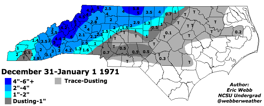
Some more quick data- The last widespread winter storm in between Christmas and New Years was the Christmas storm in 2010. Before that, only Eastern NC got any appreciable snow in the 2000s during that time frame (Dec 2004) In the 90s there was also only 1 widespread winter storm the entire decade for this time period as well (1997). In the 80s there was a mountain Christmas day snow (1981) for higher elevations for no other storms that decade. In the 70s, there were a couple smaller storms during that time but no major storms. Overall, each decade has only seen 1 usually small storm during that time frame which is typically less than other weeks in December, January, February and early March. For example, the time frame between December 4-10 has seen 2 major winter storms in the past decade alone.
.gif.a95074dfa1a455e671d370b1ea60d553.gif)
.png.469b10459ec4498beee204a0f6bdb45b.png)
-
When is it reasonable to expect something more than a basic 1-3” event?
-
close to something I think. It’s been showing a storm on the 25th.
-
December 2025 regional war/obs/disco thread
weatherwiz replied to Torch Tiger's topic in New England
The NBM does really well with sky cover forecasts I think. Out of MOS/NBM, the NBM was the only guidance bringing in these clouds through the day today followed by some clearing late afternoon/evening then increasing late.