All Activity
- Past hour
-

July 2025 Obs/Disco ... possible historic month for heat
Lava Rock replied to Typhoon Tip's topic in New England
perfect boating day. Instead, sitting in cube all day -

2025-2026 ENSO
40/70 Benchmark replied to 40/70 Benchmark's topic in Weather Forecasting and Discussion
Yea, I also feel the West Pacific being drastically different is a big reasony why the -NAO was abope to produce more readily that season compared to more recent ones. -

July 2025 Discussion-OBS - seasonable summer variability
Stormlover74 replied to wdrag's topic in New York City Metro
Going to miss these 60s and 70s for sure. Haven't seen 80 in over a week up here -
Picked up .56" from an very early morning thunderstorm which puts me at 4.89" for the month.
-
The only common thread between 10-11 and 24-25 was the La Niña mismatch. That’s why I mentioned that big caveat in my post that there were other things much different than 20-21, 17-18, and 10-11. A main reason we had the record 60”+ snows around NYC from 12-26-10 to 1-27-10 was the -NAO retrograding back west boosting the PNA enough to put us in business. You will notice we hardly snowfall during most of December and February when the PNA was so negative. That was the greatest 33 days of winter that I ever had the privilege to experience on Long Island. Unfortunately, things have shifted so much that I would be happy these days to get one third those amounts even in a whole season let alone one month. Hopefully, we can get some type of bounce off this record low snowfall pattern since 18-19 before we close out the 2020s.
-

July 2025 Obs/Disco ... possible historic month for heat
dryslot replied to Typhoon Tip's topic in New England
66/53°F under clear skies, Should get to mid 70's today, Perfection. -

July 2025 Discussion-OBS - seasonable summer variability
SACRUS replied to wdrag's topic in New York City Metro
14 years ago https://www.nbcnews.com/id/wbna43851978 -

July 2025 Obs/Disco ... possible historic month for heat
kdxken replied to Typhoon Tip's topic in New England
We took the boat out of the water.. blue skies with white clouds rolling by. Perfect day today. -
It's interesting for me ... ...just eyeballing the data over at climatereanalyzer.org's interface ... I've noticed this in the past and this above is reminding me. There seems to be a vague, albeit non-zero, positive correlation coefficient among the various years of the aggregate graph. Namely, a downward trend 'tendency' shared among them, around the last week of Junes through the first week's of Julys. Then, most years resume an upward result that arcs over an apex during the last week of July and first week ( ~) of August. The latter is understandable and intuitive. But why there'd be this subtle tendency to offset seasonal rise around July 1 ... it may be just sample size related, true. I mean there's only 20 or so years out of the last 2,000,000 presented. Ha. Perhaps it is about as interesting as it is subtle, then. It might interesting to see the deeper historical sample size. Oh ... just as an after thought - maybe even obvious? The southern polar contribution in the solar "step latitudes" where the sun briefly dips below the horizon ( not from Earth's rotation, but because of the geometry of it's revolution around the sun), might be related to that. In that 10 or so day period ... there's say, a 'shock' proficiency of energy loss in that ring latitude. The sun then reappearing during the day, however feeble, is enough to add decimals back, and that no longer offsets the total and the previous dynamic resumes.. Heh, as another after-observation ... there's a tendency at the other end, last week of Dec's, to see a trend up. That may be the mirror effect in the other direction.
-

July 2025 Discussion-OBS - seasonable summer variability
psv88 replied to wdrag's topic in New York City Metro
62 this morning. So it looks like no 50s this July. A few 62s but that’s as long as it got -

July 2025 Discussion-OBS - seasonable summer variability
bluewave replied to wdrag's topic in New York City Metro
I posted this the other day. Only a very small area around San Francisco has seen the cooler temperatures. Fits the recent theme of the cooler areas covering much less real estate against the record warmth in the Northern Hemisphere this summer. -

July 2025 Obs/Disco ... possible historic month for heat
TheClimateChanger replied to Typhoon Tip's topic in New England
Wow, in a stunning reversal from the high heat and humidity, Saranac Lake dropped to 34F, tying its daily record low set in 1914. The all-time record July monthly record low in the Saranac Lake threaded record is 29F, set on July 8, 1919. At the airport site, the all-time record low is 32F, which has been set on more than one day, last on July 28, 2001. The all-time observed record low for the month of July in the state of New York is 25F, which was set at Allegany State Park, in Cattaragus County, on July 8, 1963. Edited to remove the reference to Millbrook... I assumed that was a CRN site since xMacis labels it a "WBAN" station and not a "COOP" but it isn't and the temperature data for yesterday appears to be incorrect there. It obviously wasn't 87/32 there yesterday. Lol. -

July 2025 Obs/Disco ... possible historic month for heat
Great Snow 1717 replied to Typhoon Tip's topic in New England
..but down south people can enjoy the summer weather for many months longer than in SNE....perhaps a AMWX southern commune in the future??? -
2025-2026 ENSO
40/70 Benchmark replied to 40/70 Benchmark's topic in Weather Forecasting and Discussion
So you kind of had the right idea. There were some pretty fundamental differences from 2010-2011 beyond simply 14 years worth of GW. -
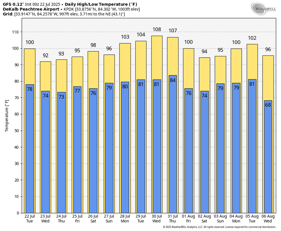
Based on the quotes I copied below from June showing the GFS as having verified as being much too hot for highs, the 0Z 7/22 GFS will almost certainly verify as too hot and likely much too hot for highs as the hottest at ATL was 95 on 6/24 and 96 on 6/25. First, here’s the laughable 0Z 7/22 GFS for KATL (0Z Euro is much cooler with hottest highs of “only” 99 on 7/30 and 101 on 7/31 and will likely come much closer): highs of 100 today vs FFC’s forecast of 96, 103 on 7/28, 104 on 7/29, 108 on 7/30, and 107 on 7/31 (Keeping in mind that FFC was almost spot on for the late June heat by being much cooler than the GFS, FFC’s forecast hottest through 7/29 is only mid 90s): Second, here are quotes of two posts I made elsewhere in late June showing the way too hot GFS progs for late June highs: “KATL is also looking brutal on the 6Zs this week with these highs: (GFS/Euro) 6/22: 96/91 6/23: 99/95 6/24: 103/102 6/25: 101/104 6/26: 94/96 6/27: 96/87 Currently FFC has ATL’s hottest on 6/25 with upper 90s, but they’re watching closely.” and ”Which did better today for highs, GFS or Euro? 6Z GFS/Euro highs today for: RDU: 103/99 vs actual of 100; Euro wins GSO: 101/100 vs actual of 95; both were terrible though Euro less terrible FAY: 99/99 vs actual of 98; both did well ATL: 102/98 vs actual of 95; Euro did better than the awful GFS but still was 3 too hot Euro also did better yesterday at GSO and FAY So for these 2 days overall, Euro did significantly better than GFS, which tended to be at least several degrees too hot.”
-

July 2025 Discussion-OBS - seasonable summer variability
Brian5671 replied to wdrag's topic in New York City Metro
someone said once "the coldest winter I ever spent was summer in San Fran" -
I linked it up yesterday showing that the mismatch analogs would be colder than what the Euro was forecasting for last winter. But in this warmer climate they probably wouldn’t be as cold as previous mismatch years. That turned out to be correct since last winter was one of the warmest on record for past instances when those parameters were met back in the colder climate.
-
2025-2026 ENSO
40/70 Benchmark replied to 40/70 Benchmark's topic in Weather Forecasting and Discussion
I got down to 49.1...it was so refreshing. -
2025-2026 ENSO
40/70 Benchmark replied to 40/70 Benchmark's topic in Weather Forecasting and Discussion
All joking aside, I will try be more mindful of seeking clarity from you in the future before passing judgement...not that you are about my take. -
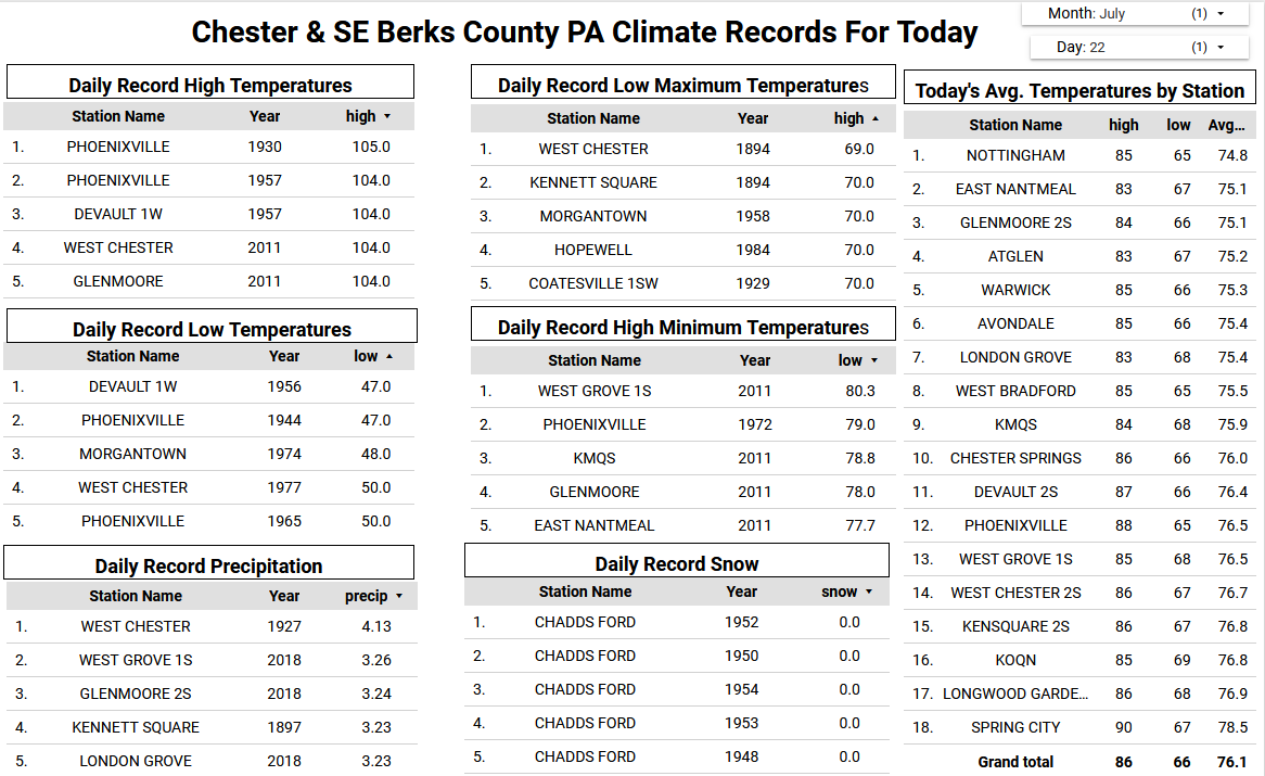
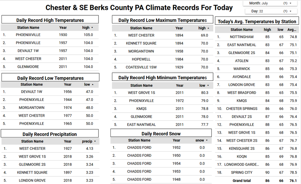
Low temperatures this morning ran between 5 and 7 degrees below normal for late July. The lowest I found was the 55.1 degree reading at Warwick Township. Another beauty of a day today with highs ranging from the upper 70's at higher spots to the low 80's in valley locations. We start a warming trend back to near normal on Thursday and then above normal temperatures by Friday with some spots cracking 90 degrees for the first time in more than a month. Shower chances return over the weekend.
-
A wonderful early fall-like morning.
-

E PA/NJ/DE Summer 2025 Obs/Discussion
ChescoWx replied to Hurricane Agnes's topic in Philadelphia Region
Low temperatures this morning ran between 5 and 7 degrees below normal for late July. The lowest I found was the 55.1 degree reading at Warwick Township. Another beauty of a day today with highs ranging from the upper 70's at higher spots to the low 80's in valley locations. We start a warming trend back to near normal on Thursday and then above normal temperatures by Friday with some spots cracking 90 degrees for the first time in more than a month. Shower chances return over the weekend.
-
2025-2026 ENSO
40/70 Benchmark replied to 40/70 Benchmark's topic in Weather Forecasting and Discussion
Great, could you link me to your seasonal temp forecast for last winter? -
Actually, Graham had heavy rains from not one but two TCs in Sept of 1999: -6.36” Sept 5-7 from Dennis -4.30” Sept 15-17 from Floyd In addition, they had 5.12” Sept 27-30 from I don’t know what (no named storm then). https://www.weather.gov/wrh/Climate?wfo=rah
-
There would be no confusion if you asked me yesterday since I keep a record of which days they were posted on. Like…Hey can you direct me to your forecast ideas from last winter? I would have said sure and directed you to the posts from last October. My snowfall outlooks were in the NYC Metro forum.