All Activity
- Past hour
-
 Mt holly isn't impressed by heavy rainfall chances
 -

Hurricane Erin: 105 MPH - 958 mb - NNW @ 10
wthrmn654 replied to BarryStantonGBP's topic in Tropical Headquarters
Yeah but I didn't realize it's 87 miles east of Erin. -

Hurricane Erin: 105 MPH - 958 mb - NNW @ 10
GaWx replied to BarryStantonGBP's topic in Tropical Headquarters
But look how much it cooled due to the energy transfer to Erin as potential energy in form of ocean warmth was converted to kinetic energy. -
It certainly is, my 5 year old grandson now has a cousin. Bone dry out there, level drop is evident in some stressed trees, only .35” for the month here.
-
A big problem has been the upper latitude pattern. This big ridge in the N. Pacific is -PNA Here's the Winter sea-level pressure pattern with PNA (map is default positive, so what's happened lately is opposite of this map) ^Notice the low SLP off the east coast. -0.3 is pretty significant correlation. We've been seeing -PNA (North Pacific pattern), so there has been more tendency downstream for High pressure along the east coast and off the coast. That's just the Pacific.. in the Atlantic since 2011-2012, 83% of the Winter months have had +NAO! In that time monthly NAO readings of >1.11 have been positive 18-0. Here's the SLP correlation with NAO, this map is default positive so in +NAO, like we have seen lately, it is like this Again, very High pressure correlation. Add the Pacific and Atlantic upper latitude patterns together and you have 5x more likely to have east coast, or off the east coast, High pressure vs Low pressure in the Winter months. That's the pattern we've been in since 2011-2012 and more so since 2016-2017. A core reason for this is the decadal La Nina state that has been in place since 1997-1998. Some say -PDO, but the Hadley Cells are flexed in the southern Hemisphere too so it's been more Nino 3.4 driven, imo. Atlantic NAO is a decadal cycle, since the 1800s there have been 4 swings between positive and negative. They usually last 30-50 years at a time. We have been in the middle of a +NAO decadal cycle. Of course the jet stream is moving north with global warming, but it's been bad timing with regard to long term global pattern fluctuations.
-
UHI acts as an amplifier of mostly the low temperatures in and around Phoenix leading to the rapid increase in 80° minimums there. But the rapid increase in 100°+ maxes is evenly distributed across, urban, suburban, and rural locations. It’s the rapid warming of the planet which is driving the increasing intensity of the heat. So the UHI acts to keep the urban centers warmer at night than the outlying areas. But both areas as seeing steep increases in the minimum and maximum temperatures. So without the background warming of the climate, the UHI alone wouldn’t be nearly as significant.
-

Mid to long range discussion- 2025
WinstonSalemArlington replied to wncsnow's topic in Southeastern States
-
Right, no one is disputing it's been hot in Flagstaff. It just hasn't warmed as much as Phoenix, as those stats clearly show. It's a distinct difference. - Two of Flagstaff's top 3 warmest summers happened more than 20 years ago. Meanwhile, those same two summers are tied for 6th hottest in Phoenix, and their three hottest are the last three summers. - Flagstaff has 5 summers among their 10 warmest that occurred 2007 or earlier. Phoenix has 2. - Flagstaff has a total of 7 20th century summers on their list. Phoenix has 3. - Phoenix's hottest summer is more than 4 degrees warmer than their hottest 20th century summer. Flagstaff's is less than 2 degrees warmer.
-
Yessss !!!
-
The simple answer is we’ve been in a long -ENSO/-PDO cycle. Northern stream dominant with a weak subtropical jet.
-
Hurricane Erin: 105 MPH - 958 mb - NNW @ 10
wthrmn654 replied to BarryStantonGBP's topic in Tropical Headquarters
Some incredibly warm water near Erin right now, about 80 miles away from this buoy!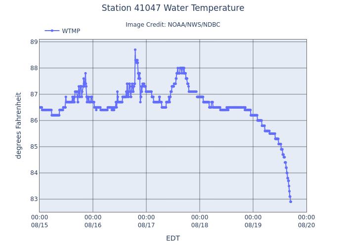
-
Lolz https://theonion.com/sam-altman-places-gun-to-head-after-new-gpt-claims-dogs-are-crustaceans-for-60th-time/
-
Hurricane Erin: 105 MPH - 958 mb - NNW @ 10
wthrmn654 replied to BarryStantonGBP's topic in Tropical Headquarters
-
Hurricane Erin: 105 MPH - 958 mb - NNW @ 10
wthrmn654 replied to BarryStantonGBP's topic in Tropical Headquarters
Here's the entire nhc track from the very beginning, it is clear as day they have been correcting west from the very beginning.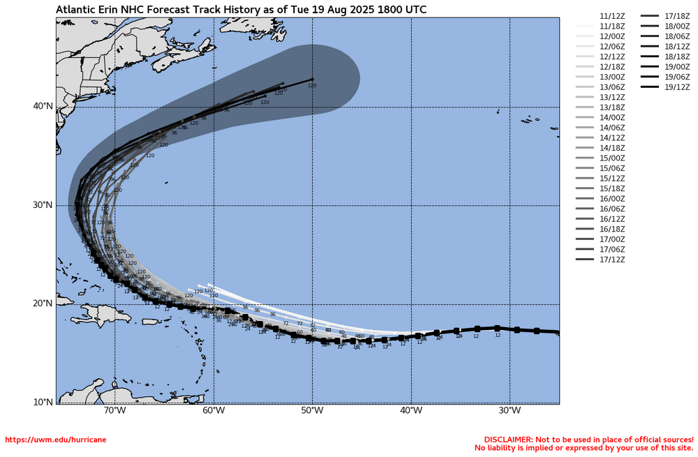
-
Hurricane Erin: 105 MPH - 958 mb - NNW @ 10
wthrmn654 replied to BarryStantonGBP's topic in Tropical Headquarters
Should be noted, there are models showing it strengthening a bit more now, i think more then before...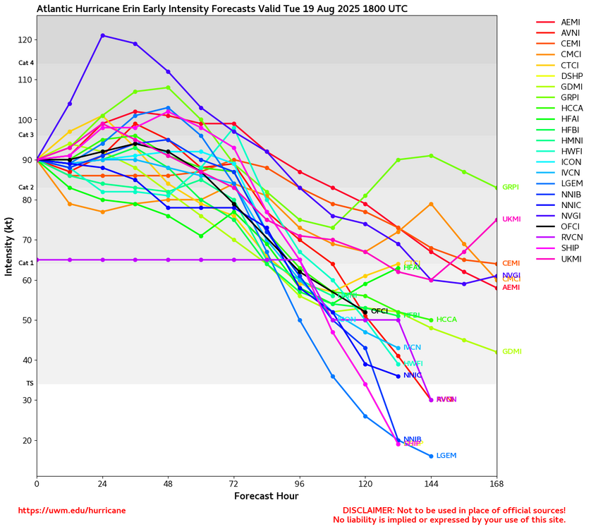
-
Hurricane Erin: 105 MPH - 958 mb - NNW @ 10
wthrmn654 replied to BarryStantonGBP's topic in Tropical Headquarters
Those have it taking a more west track too.... not being a broken pattern but icon has been unbelievably consistent and euro ai too -
Best time of the year.
-

NEW DISTURBANCE: Central Tropical Atlantic (10/60)
Wannabehippie replied to BarryStantonGBP's topic in Tropical Headquarters
That blob of convection was, and remains pretty far south. Almost at 5 degrees. The low coriolis effect will probably inhibit development. Add in the SAL, and I don't get how this is listed as an orange by the NHC. -

2025 Spring/Summer Mountain Thread
Maggie Valley Steve replied to Maggie Valley Steve's topic in Southeastern States
Starting to see signs of a significant cool down beginning this weekend and a reinforcing cold arriving next Monday. We could see lows in the 40's even down in Asheville..thumb.gif.e5576711e8f7df75037d21d6134b93c3.gif)
-
 RGEM is also north as well...although it gives many of us .50 I'd gladly take that
 -
 I can't think of a PRE that was ever decent IMBY. They're good inland over NJ or the Hudson Valley.
 -
Amazing BW ….. 3 of the top 5 occurred within the last 4 years. As always …..
-
Congratulations to all! It's great to be grandparents
-
Hurricane Erin: 105 MPH - 958 mb - NNW @ 10
Wannabehippie replied to BarryStantonGBP's topic in Tropical Headquarters
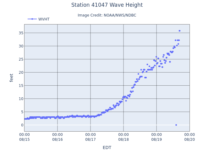
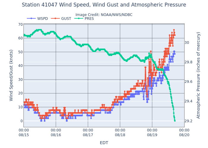
5:00 PM EDT Tue Aug 19 Location: 26.6°N 72.7°W Moving: NNW at 10 mph Min pressure: 958 mb Max sustained: 105 mph No change in intensity since the 2pm advisory.


.gif.3b15457f0c0217e805a4cc2ae7317508.gif)

