All Activity
- Past hour
-
Yeah I'm a little late changing from my Fall pic aren't I?
-

Moderate snowfall 12/14/2025 WWA up for most of the area
wthrmn654 replied to WeatherGeek2025's topic in New York City Metro
Lol at the name changing game for this topic. Snow storm title isn't being allowed haha -

December 11th-14th Double Banger Clippers
cyclone77 replied to Jackstraw's topic in Lakes/Ohio Valley
Yeah. Precip is sliding southeast. Was able to catch a little bubble of heavy snow as it rode southeast from Cedar Rapids. We're in 1.5-2 mile type vis with pixies now. Very strange how we rode the extreme northern edge with both clippers. Usually back to back clippers vary more in their tracks. -

December 14th - Snow showers or Plowable snow?
RUNNAWAYICEBERG replied to Sey-Mour Snow's topic in New England
Not sure why. We tried. -
-10's across NE MN (some -20's) even on the shoreline. Wind chills in the -30's to -40+ in some places. Bitter am. Picked up a 1/4" of snow yesterday. -12 in town here is tied 6th coldest this morning. Another bitter day tomorrow, then things start to warm
-
 this is looking like a nice snow event, very excited for this!
 -
I expect a new snowy cabin profile pic!
-
3" seems like a decent floor right now based guidance. Was thinking more 2-2.5" yesterday. 4" might be a stretch, but possible.
-
I'm a little worried about some models running on the north end of the envelope we've seen, I think at this point the fail case for 95 is temps come in a tad high and a slightly overamped storm screws us with too much rain in the early morning to get much. Fingers crossed we see the GFS or something like it pan out...
-
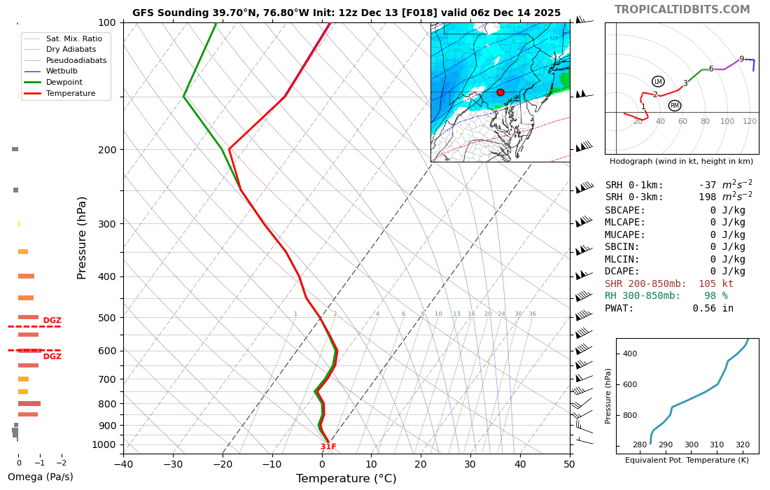
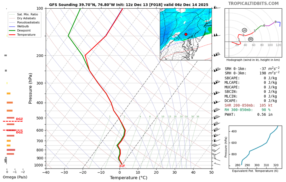
Nice sounding in the band as it starts cranking around 1am in @mappyland
-
I told y'all in my post last night it was happening and why. It has been incremental over several runs as guidance has been getting a better handle on the h5 vorticity interactions.
-
I think you get 3" of snow from this.
-
Its more that Scandinavian block is more SW on some ensembles now. Unfortunately the WPO/EPO the last couple of cycles are becoming unfavorable again but thats also out at D14-16 so not highly confident in any of the changes
-

12/14: Sunday funday? Will the south win again?
Maestrobjwa replied to TSSN+'s topic in Mid Atlantic
Weenie run for Baltimore! -
I honestly don’t remember the last December snow for me outside some snow showers or like 1” or whatever. I was in Westminster before this past year.
-

December 14th - Snow showers or Plowable snow?
UnitedWx replied to Sey-Mour Snow's topic in New England
Nantucket Sleigh Ride... sounds like what they must call coke and lsd after hearing that -

Central PA Winter 25/26 Discussion and Obs
pasnownut replied to MAG5035's topic in Upstate New York/Pennsylvania
Fwiw, nooner GFS continues the westward tick in qpf for LSV. Not much more room for further adjustments, but I81 and points SE should have plows down (cause ya know they plow 1/4" or greater). Hoping for another HH tick west to bring Carlisle and Blizz into the good stuff as well. -
There is another one coming Keep trolling
-
December 14th - Snow showers or Plowable snow?
UnitedWx replied to Sey-Mour Snow's topic in New England
I would agree. Someone may be confused, but get an inch or two on cold roads, the general SEVERE LACK of driving skill by many now and the holiday season warrants advisories if this keeps looking like current guidance -

12/14: Sunday funday? Will the south win again?
winter_warlock replied to TSSN+'s topic in Mid Atlantic
I'll take that for 2000 alex!!! -

December 11th-14th Double Banger Clippers
Radtechwxman replied to Jackstraw's topic in Lakes/Ohio Valley
That weenie band just south of DVN going to miss you? -
Some personal MBY stats. Biggest December snowfall since 2009 is 3.3", which happened in both 2017 and 2020. Think I got a puncher's chance to top that.
-

December 11th-14th Double Banger Clippers
OHweather replied to Jackstraw's topic in Lakes/Ohio Valley
Pretty cool how there's literally no surface reflection with this clipper. All the snow is driven by mid-upper level jet dynamics and frontogenesis.
-
Hey I don’t use a computer, I use my phone so ha! Lol.
-
12/14: Sunday funday? Will the south win again?
winter_warlock replied to TSSN+'s topic in Mid Atlantic
Looking a lil bit more like an actual storm there, unless I'm seeing things it looks like a lil bit of a coastal signal there compared to 06z...