All Activity
- Past hour
-

Feb 22nd/23rd "There's no way..." Storm Thread
Weather Will replied to Maestrobjwa's topic in Mid Atlantic
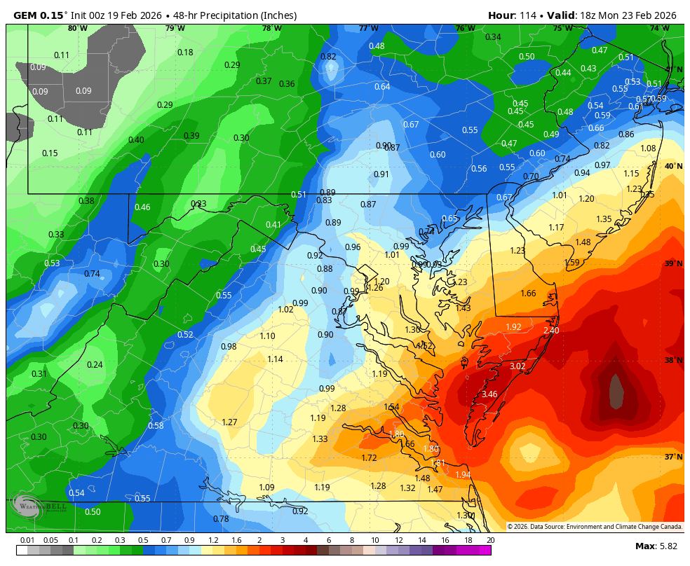
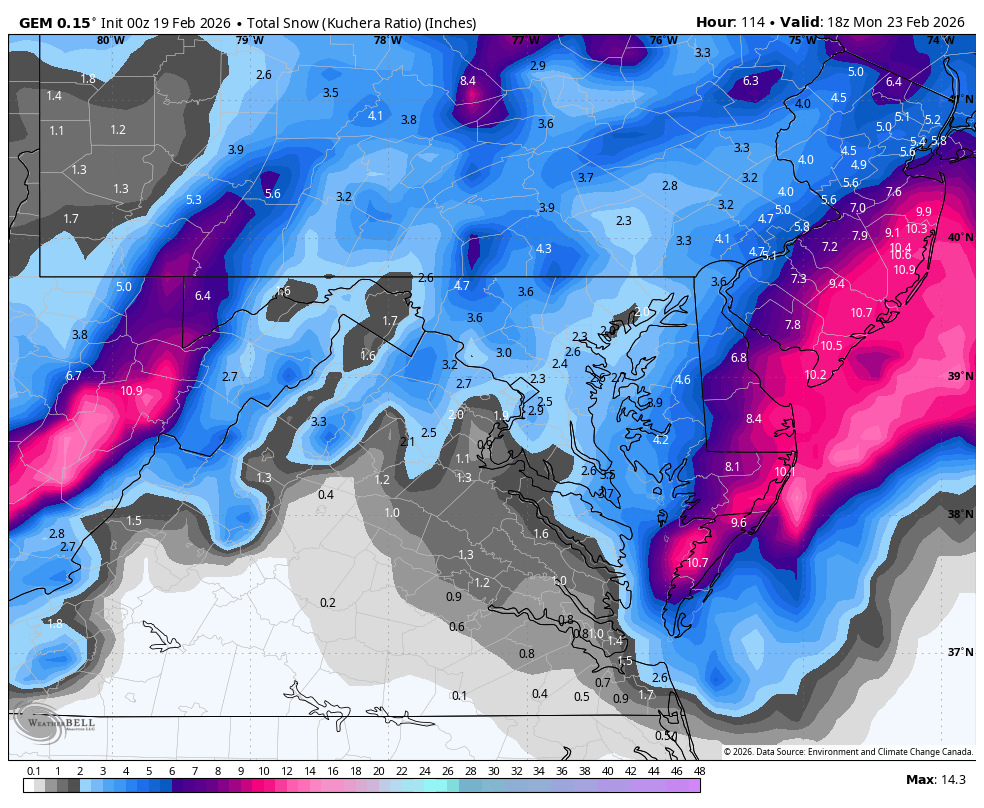
WB 0Z Can.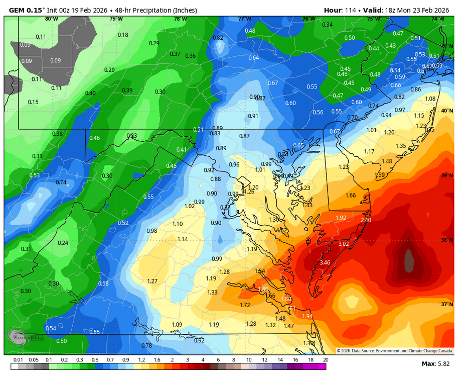

-
Both
-
But every member is southeast of the OP, which is pretty close to the southern part of the delmarva.
-

“Cory’s in NYC! Let’s HECS!” Feb. 22-24 Disco
Ginx snewx replied to TheSnowman's topic in New England
70 knots at 925 blizzard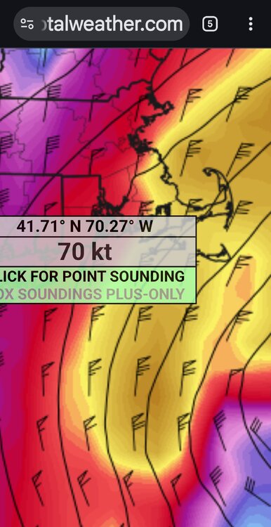
-

Feb 22nd/23rd "There's no way..." Storm Thread
wasnow215 replied to Maestrobjwa's topic in Mid Atlantic
CMC maps? -
Feb 22nd/23rd "There's no way..." Storm Thread
Weather Will replied to Maestrobjwa's topic in Mid Atlantic
Retirement is a wonderful thing....you can stay up and annoy people all night with maps they hate.... young folks put away even a little every pay check into your 401k....you won't regret it!!!! Oh and I'm still in my 50s... -

“Cory’s in NYC! Let’s HECS!” Feb. 22-24 Disco
weathafella replied to TheSnowman's topic in New England
One historically memorable but several moderate events. Best winter in 4 years. -

Central PA Winter 25/26 Discussion and Obs
Blizzard of 93 replied to MAG5035's topic in Upstate New York/Pennsylvania
The 0z Canadian gets a healthy coastal low going off of the coast of Norfolk, but then it slides mostly east from there as it intensifies. The LSV gets some snow from the coastal & then tacks on from the Norlun as the storm exits east. Long way to go, but I like seeing the 0z GFS & Canadian keeping us in the game for a Warning level chance. I think the odds of an Advisory level event for us are certainly increasing.
-
Feb 22nd/23rd "There's no way..." Storm Thread
wasnow215 replied to Maestrobjwa's topic in Mid Atlantic
Liquid or pill? -

MO/KS/AR/OK 2025-2026 Winter Discussion
Golf757075 replied to stormdragonwx's topic in Central/Western States
I don't see anymore snow/ice if the ao/epo don't trend negative imo -

“Cory’s in NYC! Let’s HECS!” Feb. 22-24 Disco
TauntonBlizzard2013 replied to TheSnowman's topic in New England
Will be a fitting end to this winter to whiff on all 3 potential snow events this week down here. One memorable event -

Feb 22nd/23rd "There's no way..." Storm Thread
ravensrule replied to Maestrobjwa's topic in Mid Atlantic
Impressive, i thought that started ages ago. -

Feb 22nd/23rd "There's no way..." Storm Thread
mitchnick replied to Maestrobjwa's topic in Mid Atlantic
Nope....not yet at least. -
“Cory’s in NYC! Let’s HECS!” Feb. 22-24 Disco
weathafella replied to TheSnowman's topic in New England
GFS AI is bupkis for the most part. -

Feb 22nd/23rd "There's no way..." Storm Thread
winter_warlock replied to Maestrobjwa's topic in Mid Atlantic
Don't add me. I gotta get up at 5 30 am so I won't be up with the overnight crew -
Feb 22nd/23rd "There's no way..." Storm Thread
ravensrule replied to Maestrobjwa's topic in Mid Atlantic
He has a lot to scratch. -
Gefs coming in better
-
Yeah odds are against it given the seasonal trends but it's fun having something to track. And at least spring is around the corner.
-
Feb 22nd/23rd "There's no way..." Storm Thread
ravensrule replied to Maestrobjwa's topic in Mid Atlantic
Adult diapers work great, just ask @mitchnick. -

Feb 22nd/23rd "There's no way..." Storm Thread
Solution Man replied to Maestrobjwa's topic in Mid Atlantic
Healthy Scratch tonight -

Feb 22nd/23rd "There's no way..." Storm Thread
DDweatherman replied to Maestrobjwa's topic in Mid Atlantic
By this time tomorrow night TS will be ready for spring again saying he doesn’t care about the models or snow lol. -

Feb 22nd/23rd "There's no way..." Storm Thread
LordBaltimore replied to Maestrobjwa's topic in Mid Atlantic
Not bad for pity snow -

Feb 22nd/23rd "There's no way..." Storm Thread
baltosquid replied to Maestrobjwa's topic in Mid Atlantic
You know what they say. The biggest factor for snow is your... longitude. -
I am on the IR report. Shitty toilet.
-
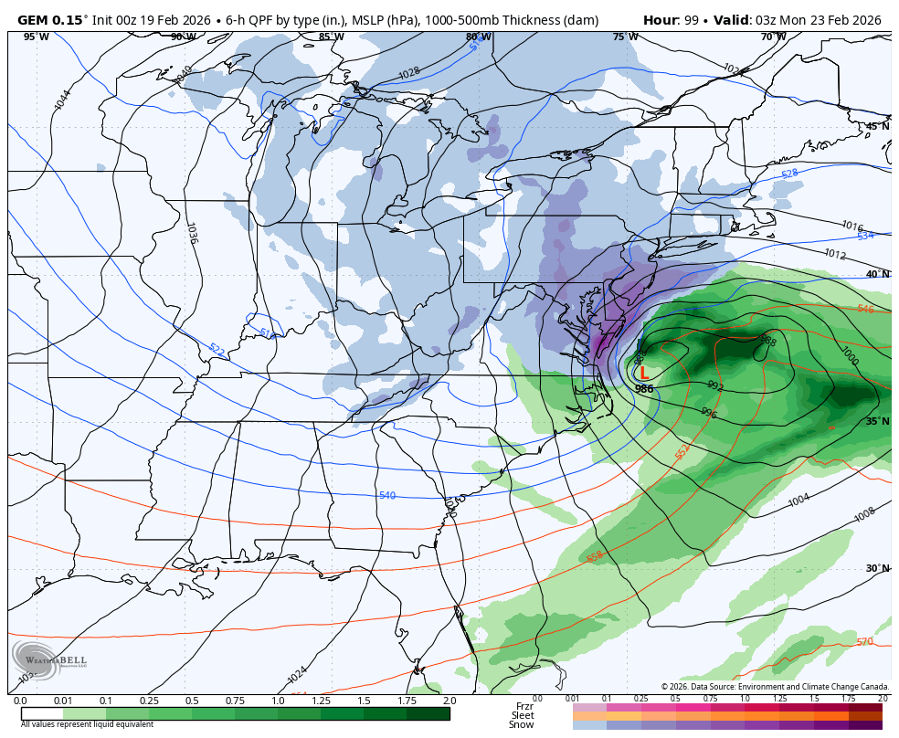
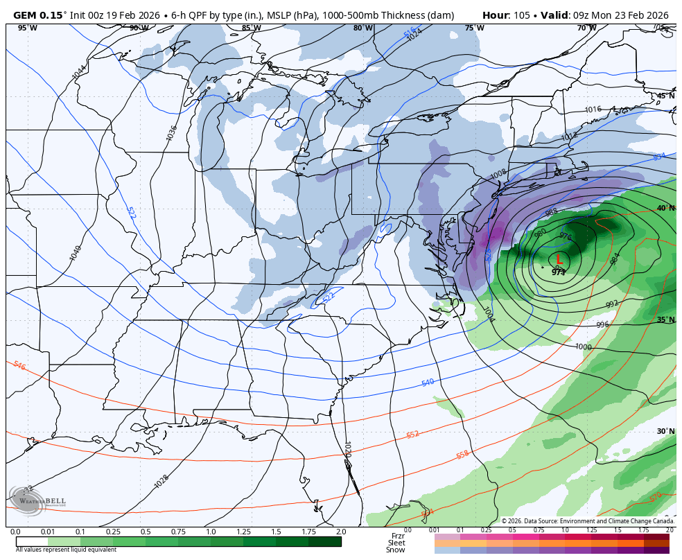
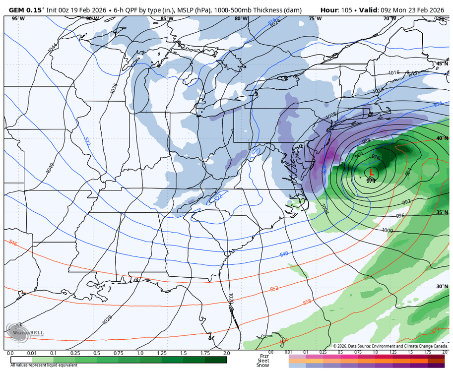
yup. Unlike the GFS and CMC, which are still "wide right", the UKMET lingers a piece of energy over SE Canada that suppresses heights along the coast and forces the system easy instead of NNE then NE