All Activity
- Past hour
-

October Comes Early: Late September Multi-Hazard Hybrid Storm
CoastalWx replied to WxWatcher007's topic in New England
Jesus hope you heal up Jeff. -

Strong Nor'Easter/Hybrid Storm Late September 2026
MANDA replied to Rjay's topic in New York City Metro
Only good thing with this scenario as shown is it keeps the wind trajectory more NNE to N and that would keep water from piling onto the coast. Still questions on how this all eventually plays out. Complex evolution for sure. -

October Comes Early: Late September Multi-Hazard Hybrid Storm
Bostonseminole replied to WxWatcher007's topic in New England
yikes.. hope you heal quickly -
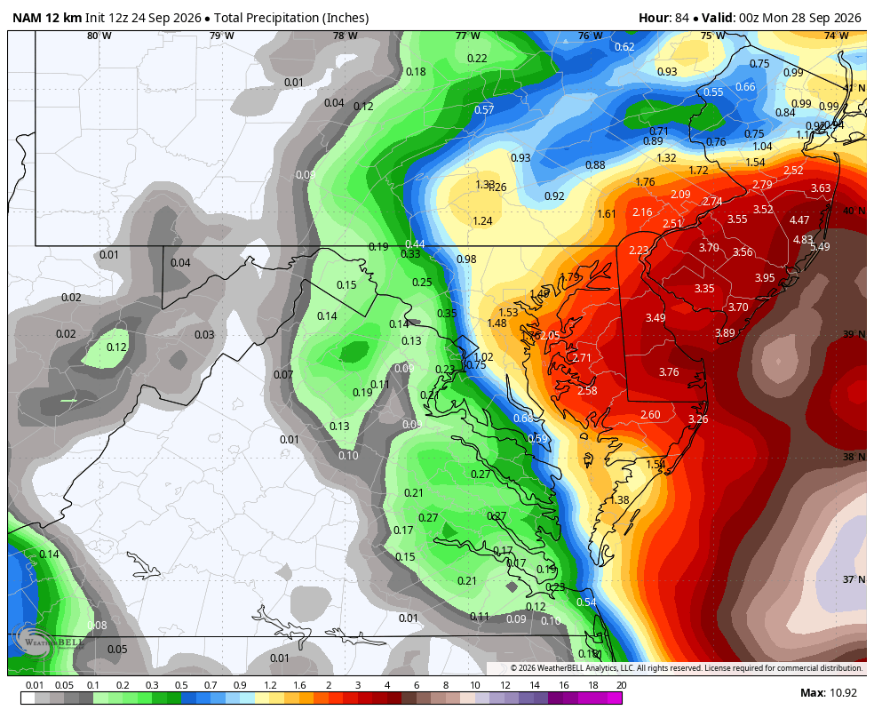
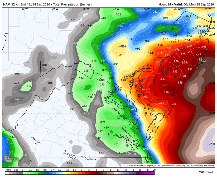
WB 12Z 12K NAM at range... glad it's not winter...
-
Looks like Fay will be the biggest ACE producer this year behind Bertha. Will also have the most Named Storm Days behind Bertha. We continue to nickel and dime our way to 10 ACE points. Currently sitting at 6.7.
-

October Comes Early: Late September Multi-Hazard Hybrid Storm
ROOSTA replied to WxWatcher007's topic in New England
OUCH! I hope that feels better than it looks. Praying that it fixes your ailment. Personally, been there, after a dozen stints, arteries moved around and replaced, then triple bypass. and it gets better... old age sucks. Hoping this nor'easter is a forbearer of an active Fall and Winter Quite anomalous getting dews to drop below 70 before Nov. I'll take it. -
October Comes Early: Late September Multi-Hazard Hybrid Storm
Bostonseminole replied to WxWatcher007's topic in New England
ICON still looks rainy here.. looks like almost 10" OF RAIN in Boston if my eyes are working! -

October Comes Early: Late September Multi-Hazard Hybrid Storm
WxWatcher007 replied to WxWatcher007's topic in New England
ICON fwiw, is a good hit. -

Strong Nor'Easter/Hybrid Storm Late September 2026
NJwx85 replied to Rjay's topic in New York City Metro
I think the mostly offshore, low to no impact solutions are off the table now. The storm is already forming. -

Strong Nor'Easter/Hybrid Storm Late September 2026
Brian5671 replied to Rjay's topic in New York City Metro
heavy rains of 4-8 inches east LI and CT -
That's So Nina
-
Haha. Trying to get my "replies" up. The worst of all this will be beach eroision. Inland breezy with some rain.
-
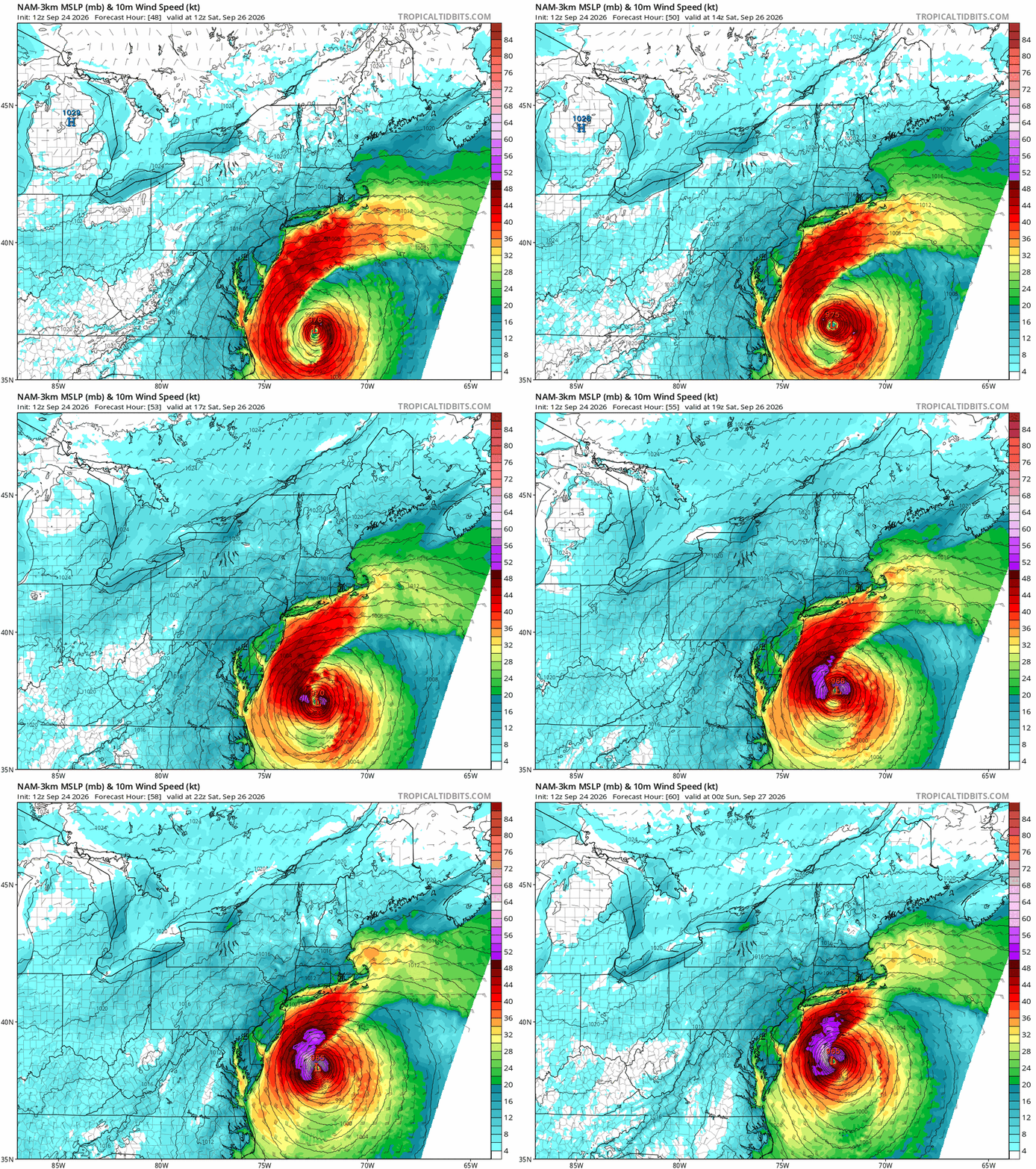
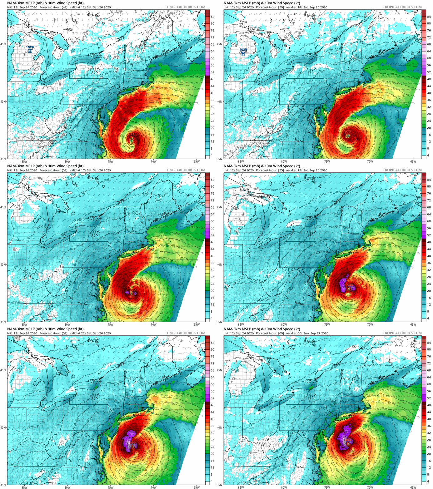
3k Nam says Nyet to most.
-

October Comes Early: Late September Multi-Hazard Hybrid Storm
OrangeCTWX replied to WxWatcher007's topic in New England
Can’t wait to see the 3k NAM thrown out all over twitter by a bunch of bots. So dumb. -
Strong Nor'Easter/Hybrid Storm Late September 2026
NJwx85 replied to Rjay's topic in New York City Metro
The 12z RGEM is an intense storm too but because of where it stalls, the winds would be northerly, and then offshore, saving the NJ coast from the worst flooding. -
You are as bad as everyone on twitter showing these 925MB maps... Where is the mountains in NJ. LOL
-
Strong Nor'Easter/Hybrid Storm Late September 2026
Brian5671 replied to Rjay's topic in New York City Metro
We got to Ocean City in August and they just finished up a beach replenishment project-wonder how much of it they lose this weekend? -

Septorcher 2026 Discussion - Endless Summer
weatherwiz replied to Damage In Tolland's topic in New England
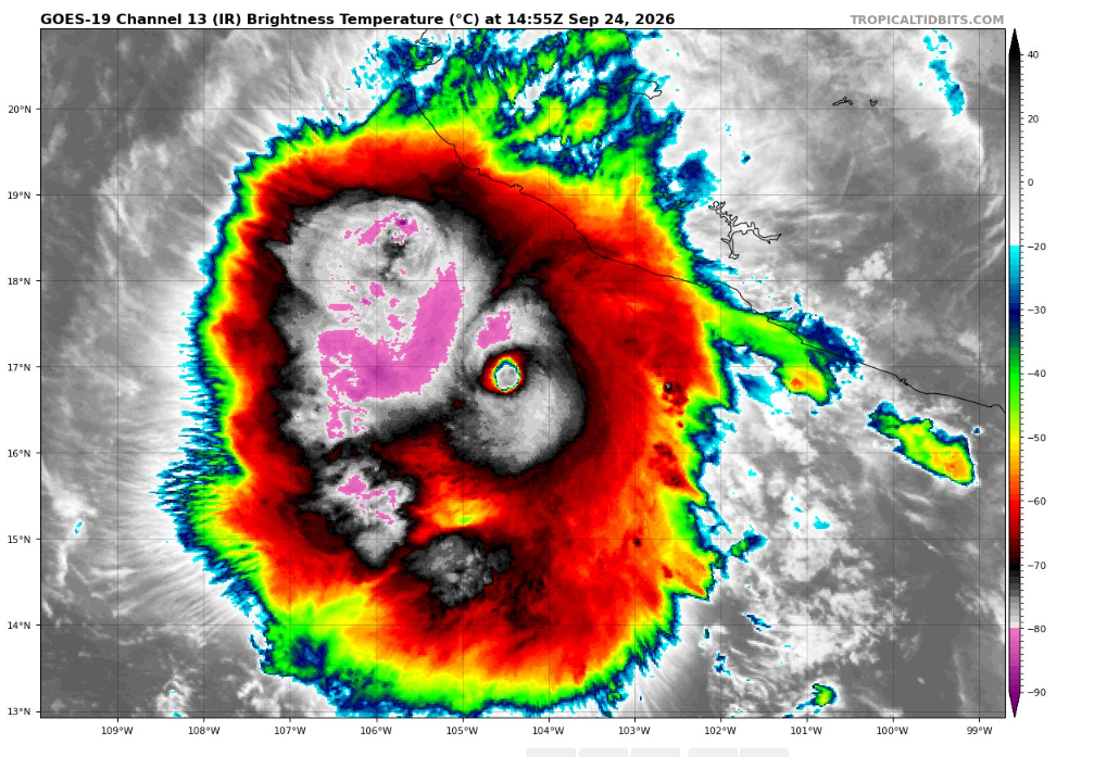
Polo is just something else. Jaw dropping satellite imagery this past week. Also seems like Nolo may be become better organized too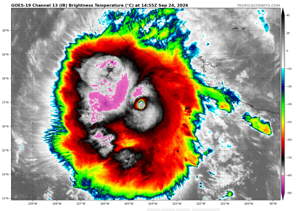
-
October Comes Early: Late September Multi-Hazard Hybrid Storm
WxWatcher007 replied to WxWatcher007's topic in New England
Yikes. Hopefully you make a full and speedy recovery. -
Strong Nor'Easter/Hybrid Storm Late September 2026
NJwx85 replied to Rjay's topic in New York City Metro
Also the timing is wildly different. The storm is still intensifying as the run ends. And there’s a ridiculous amount of rain lurking just offshore. -

Strong Nor'Easter/Hybrid Storm Late September 2026
East of the Parkway replied to Rjay's topic in New York City Metro
Still terrible for the NJ shore -
Strong Nor'Easter/Hybrid Storm Late September 2026
Brian5671 replied to Rjay's topic in New York City Metro
that's much difference than the 12K NAM which sends it into the DELMARVA -
From NHC: Resilient Fay has strengthened this morning. Deep convective curved bands have developed both on the west and east sides of the cyclone, and a small cold cloud top deep burst of convection is persisting over the surface center. Based on the improved cloud pattern and an increase in the Dvorak satellite intensity estimated from TAFB, the initial intensity is raised to 45 kt. Fay remains over warm ocean waters and a favorable upper-level wind environment. Only a relatively stable, dry surrounding atmosphere is preventing Fay from strengthening significantly. By the weekend, deep-layer shear is expected to increase, which should induce a weakening trend. Subsequently, Fay is forecast to degenerate into a remnant low. Fay's initial motion is estimated to be due west, or 270/5 kt. This general motion should continue with a slight reduction in forward speed through dissipation on Sunday. The NHC track forecast is similar to the previous advisory and lies close to the skilled HFIP HCCA and GDMI TC ensemble mean. FORECAST POSITIONS AND MAX WINDS INIT 24/1500Z 29.8N 41.2W 45 KT 50 MPH 12H 25/0000Z 29.8N 42.0W 50 KT 60 MPH 24H 25/1200Z 29.7N 42.9W 45 KT 50 MPH 36H 26/0000Z 29.6N 43.9W 40 KT 45 MPH 48H 26/1200Z 29.5N 45.2W 30 KT 35 MPH...POST-TROP/REMNT LOW 60H 27/0000Z 29.5N 46.0W 30 KT 35 MPH...POST-TROP/REMNT LOW 72H 27/1200Z...DISSIPATED $$ Forecaster Roberts
-

E PA/NJ/DE Autumn 2026 Obs/Discussion
The Iceman replied to PhiEaglesfan712's topic in Philadelphia Region
The old EE rule in effect now... would be crazy tidal flooding I would think with the prolonged NE fetch. -
Strong Nor'Easter/Hybrid Storm Late September 2026
NJwx85 replied to Rjay's topic in New York City Metro