All Activity
- Past hour
-

Possible Record Breaking Cold + Snow Sunday 1/25 - Tuesday 1/27
SnoSki14 replied to TriPol's topic in New York City Metro
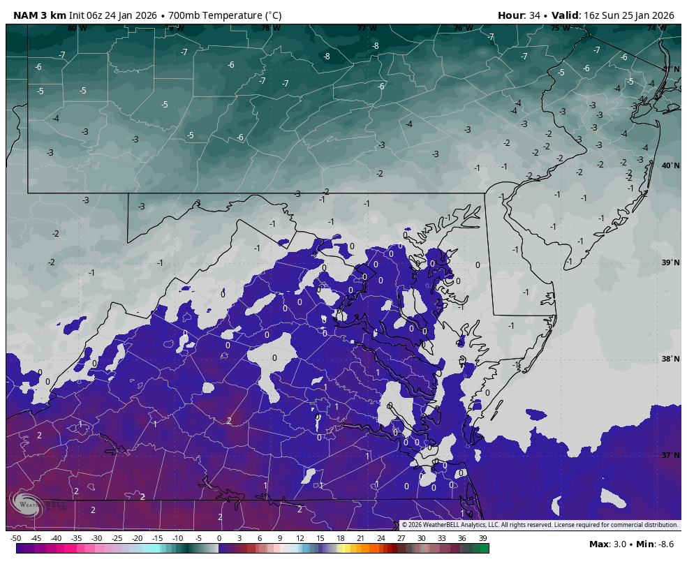
6z Nam looks a lot better than 0z...much more in line with other models -
-

Jan 24-26 Weekend Snow and Sleetfest Model Thread Part Tres
Weather Will replied to H2O's topic in Mid Atlantic
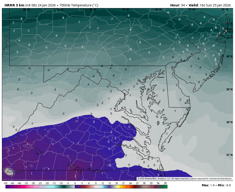
WB 3K NAM is warmer aloft than 6Z HRRR. For example, 11 am Sunday. We will see which model is wrong.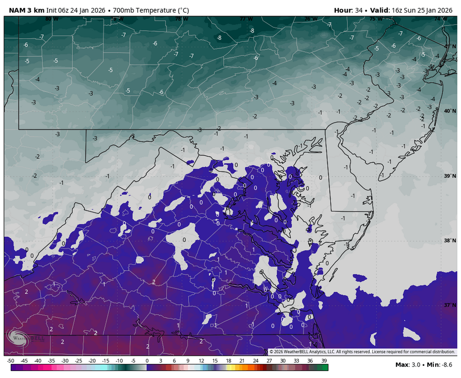

-
-

January 2026 regional war/obs/disco thread
TheSnowman replied to Baroclinic Zone's topic in New England
Yes, because it was the ONE YEAR I was home during this period of NAMM and the Grammys since they were cancelled for Covid. And WOULDN’T YOU KNOW IT…. A FAILED Disaster Storm happened. Of Course. FML. -

Jan 24-26 Weekend Snow and Sleetfest Model Thread Part Tres
TSSN+ replied to H2O's topic in Mid Atlantic
Not buying it -
Jan 24-26 Weekend Snow and Sleetfest Model Thread Part Tres
Weather Will replied to H2O's topic in Mid Atlantic
WB 3K NAM does not have the thump like HRRR. I think that is part of its problem or the reason it transitions to sleet faster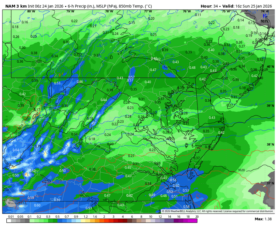
-
Jan 24-26 Weekend Snow and Sleetfest Model Thread Part Tres
TSSN+ replied to H2O's topic in Mid Atlantic
Yes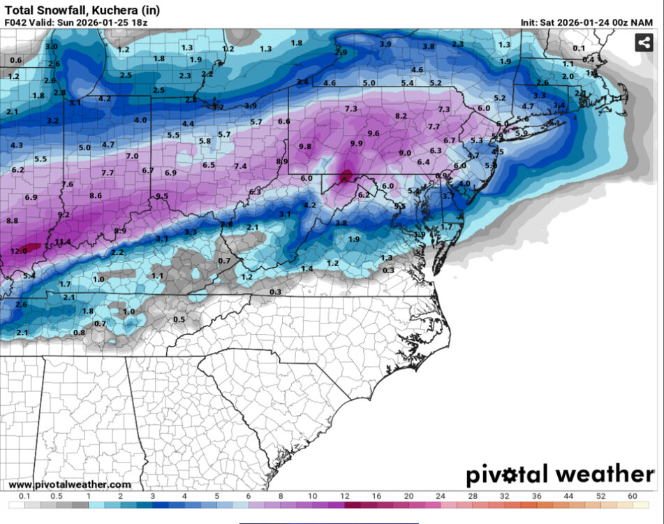

-
GRR is sitting at -16. Daily record is -20. All time is -24. There’s some -20s showing up in more rural areas nearby though. It seems like higher dewpoints are holding temperatures higher some places. It’s hard to get extreme lows here in West Michigan as normally westerly flow off the lake doesn’t diminish until the coldest core of 850 temps has passed. This is kind of a rare setup where the 850 cold pool is stalling directly overhead with light winds.
-

Jan 24-26 Weekend Snow and Sleetfest Model Thread Part Tres
Interstate replied to H2O's topic in Mid Atlantic
8.6/-6.6 -

Jan 24-26 Weekend Snow and Sleetfest Model Thread Part Tres
Maestrobjwa replied to H2O's topic in Mid Atlantic
A slight improvement, perhaps? -

Jan 24-26 Weekend Snow and Sleetfest Model Thread Part Tres
yoda replied to H2O's topic in Mid Atlantic
-
Wow TWC app radar is showing snow is currently just west of Nashville. And future shows it in knox around 8am. Not sure how accurate their future radar is.
-

Texas 2026 Discussion/Observations
Stx_Thunder replied to Stx_Thunder's topic in Central/Western States
0Z GFS, NAM runs tonight appear to be coming in line with 1 - 2 in. total icing, in ETX this weekend. Either way, things are definitely still looking highly impactful there. -
Jan 24-26 Weekend Snow and Sleetfest Model Thread Part Tres
TSSN+ replied to H2O's topic in Mid Atlantic
Nope it warms up just as fast -
Jan 24-26 Weekend Snow and Sleetfest Model Thread Part Tres
TSSN+ replied to H2O's topic in Mid Atlantic
Nam so far is coming in colder initially and the high is a little stronger, lets see if that ales a difference -

Southern Crippler - Get well soon Jimbo Storm Obs
DTP replied to BooneWX's topic in Southeastern States
39/19 in Tega Cay with NE @ 7 Up from 34 at midnight Clouds beginning to filter in -

Pittsburgh/Western PA WINTER ‘25/‘26
blackngoldrules replied to Burghblizz's topic in Upstate New York/Pennsylvania
Years ago, before I met my late wife and moved to South Park, and later Bethel Park, I grew up and lived in Westmoreland County. If you know where New Stanton is, about 5 or 10 minutes from there. Usually when a big storm like this would hit the area, I would almost always get more snow, and usually quite a bit more, than Pittsburgh and Allegheny County. After moving to the South Hills, and storms hit, my parents would always tell me they got more than me. Looks like here is one rare instance where I may get more than them for a change IF that warmer air gets to them and cuts their totals down some. Sent from my SM-S931U using Tapatalk -
I think that's more of a warm finger rather than a warm nose at this point lol.
-

Possible Record Breaking Cold + Snow Sunday 1/25 - Tuesday 1/27
TriPol replied to TriPol's topic in New York City Metro
3 am thoughts: When it does snow, it's going to be the heaviest snow some of us have ever seen in our lives. Think 2" - 3" per hour snow. Literally puking snow. -

Possible Record Breaking Cold + Snow Sunday 1/25 - Tuesday 1/27
Noteaster101 replied to TriPol's topic in New York City Metro
I’m here in Rockland County in a very sweet spot, the mixing shouldn’t affect my area too much, believe me, I’m ready!! -
Possible Record Breaking Cold + Snow Sunday 1/25 - Tuesday 1/27
Noteaster101 replied to TriPol's topic in New York City Metro
I don’t think that’s happening with all the models showing, you might be lucky to squeeze out 3 to 5 inches on the island before an icy mix comes your way -

Pittsburgh/Western PA WINTER ‘25/‘26
jwilson replied to Burghblizz's topic in Upstate New York/Pennsylvania
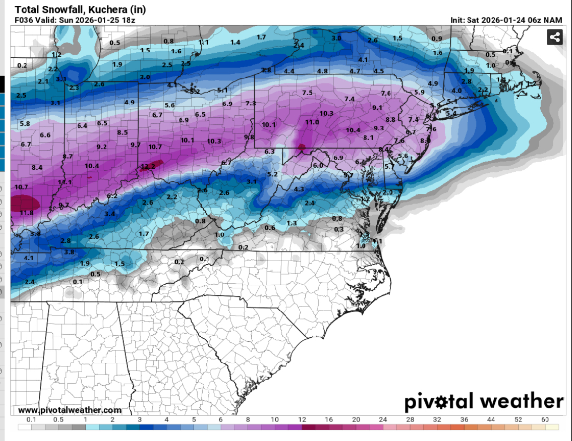
NBM is finally working again. Average precip on the 1 UTC run is 0.88" equating to a mean of 11.4" of snow. Spread is 11 to 15 between Saturday and Sunday. 70% chance of >12", 96% chance of >8" (which is somewhat nutty). That's all at PIT; odds are slightly better at AGC, actually, because of the presumably better rates. 74% and 97%, respectively. Non-snow peak odds are later on Sunday at 11% chance of rain compared to 78% chance of snow. I'm guessing that's picked up mostly by the group of mesos that are showing a warm tongue/small dry slot. I still don't like how close the primary comes to our area. Typically, when that does happen, we change over south of the city. The thermal profiles on all the models check out, but I guess it depends how much you trust them to handle the microclimate. Bufkits for NAM and GFS are all snow at AGC. Between 10" and 13" depending on the run. Ratios aren't great, so any improvement there means more accumulation. 0Z NAM actually barely gets above 10:1 the entire duration. Max is 12:1 except for a brief period of 21:1 at the tail end on 1.33" of QPF (high). That's why storm total is "only" twelve inches. If I had to do a first call, I'd probably go a little conservative on the southern regions of Allegheny, Washington, Greene, and Fayette (Mon Valley): 8" to 14" - 6" to 8" at MGW, less points south - 10" to 14" city points north. Any mesoscale banding that takes place has a significant impact on localized totals because of convergence and associated divergence. Could see lollipops of 16" somewhere in the coverage area. It's arguably low for city-south, but perhaps I'm paranoid. Too many years in MGW. I might adjust that upward tomorrow as more mesos come into confidence range. I think closer to the 8" figure if there's mix/sleet, closer to 14" if there's a clean hit. I still don't necessarily trust the models on thermals assuming the northern progression of the primary low is correct. I'll revisit this thought after the storm. Anyway, just my word vomit. It's 3 AM, give me a break! -
 It might. But do not misinterpret what the Euro and to a greater extent other models have shown. The thrill of this event will be the heavy snow. When the dynamics begin to lift to our north and east some warmer air at upper levels causes some mixing and possibly a brief changeover Sunday night. But by the time this happens almost all the most significant precipitation most likely has fallen. Therefore the greater snow amounts we are seeing on the GFS and the operational Euro. Euro AI is probably overdoing the influx of warmer air at the upper levels as I suspect is NAM. WX/PT
 -

Pittsburgh/Western PA WINTER ‘25/‘26
MikeB_01 replied to Burghblizz's topic in Upstate New York/Pennsylvania
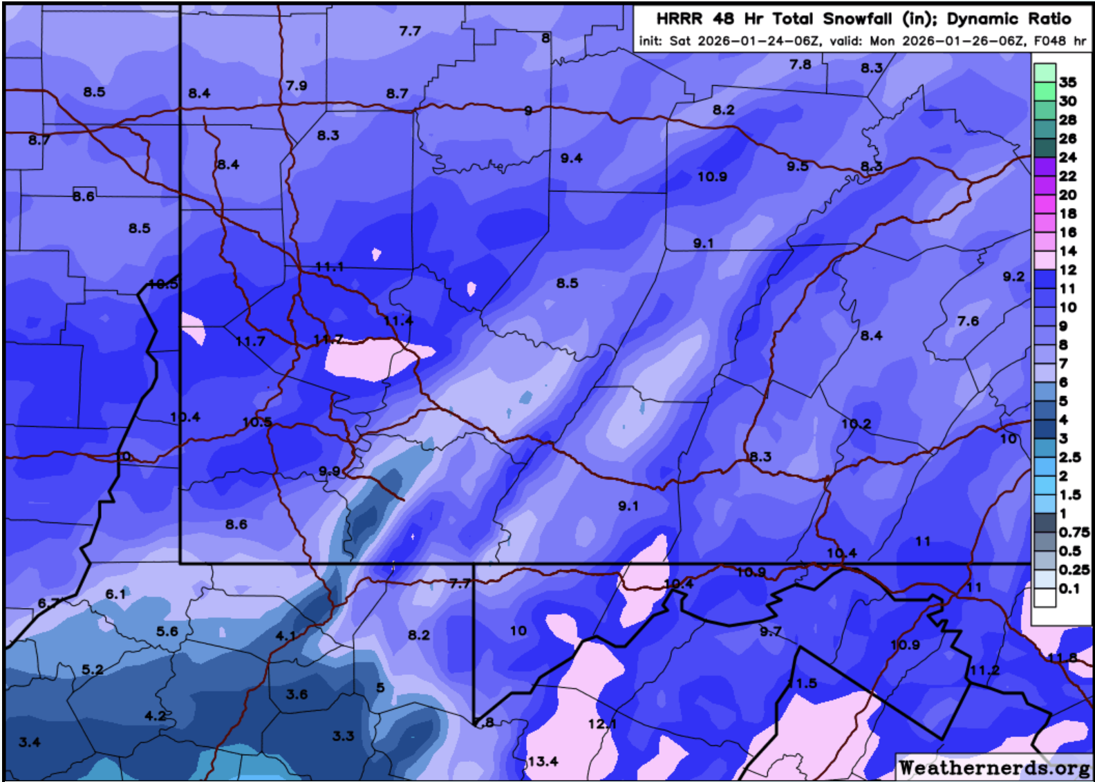
in case you wanted to see it really close up for our area