All Activity
- Past hour
-

July 2025 Obs/Disco ... possible historic month for heat
ineedsnow replied to Typhoon Tip's topic in New England
Do you honestly think a heat advisory was needed today? -

July 2025 Obs/Disco ... possible historic month for heat
Torch Tiger replied to Typhoon Tip's topic in New England
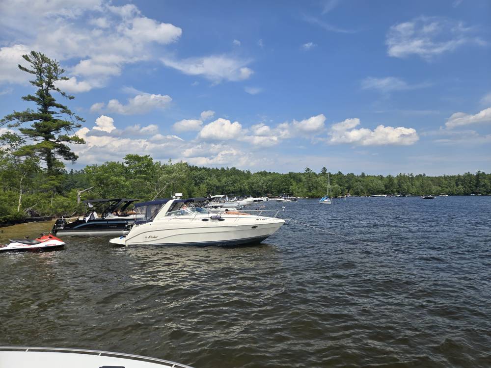
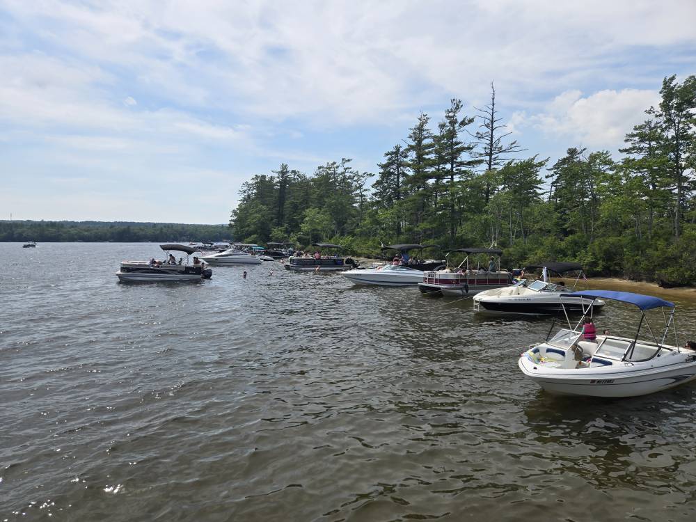
Gorgeous out there, near-perfect -

July 2025 Obs/Disco ... possible historic month for heat
powderfreak replied to Typhoon Tip's topic in New England
I'm the biggest cold fan out there, trust me. Just call it like I see it, ha. -

July 2025 Obs/Disco ... possible historic month for heat
CoastalWx replied to Typhoon Tip's topic in New England
Man ACATT tries. It’s cute. -
Quite Frankly, models suck with 2m temp anomalies in the medium range, never mind a seasonal forecast. It's pretty much useless to look at IMO. They are a little better with 850 temp anomalies but not much. It's best to just look at their 500mb anomaly forecasts and that will give you an idea on what temp anomalies would be if that particular map was to come to fruition.
-

July 2025 Obs/Disco ... possible historic month for heat
Lava Rock replied to Typhoon Tip's topic in New England
Great lake day Sent from my SM-S921U using Tapatalk
-
Unfortunately, some people are too naive, stubborn, ignorant or deluded by others to recognize the preponderance of actual evidence and real world events that point to an oncoming conclusion. Just how it is- they then hear their own echo chamber or are goaded by others. For the greater good- I think these people should be politely ignored by those not so afflicted. See Isaac Cline - 1900 Galveston Hurricane.
-
Huge increase in rainfall from the WPC in its afternoon update today. Dry periods do not last long.
.gif.9affd8c32487b304e81fdaeda690d4bd.gif)
-

2025-2026 ENSO
40/70 Benchmark replied to 40/70 Benchmark's topic in Weather Forecasting and Discussion
I feel pretty good about next season not being a complete blood bath is all I mean. -

E PA/NJ/DE Summer 2025 Obs/Discussion
RedSky replied to Hurricane Agnes's topic in Philadelphia Region
ECM also a nothing burger .25" or less from the depression Considering a butterfly flapping it's wings has been making it rain heavy I doubt guidance -
Just state with years lol I mentioned many....
-
July 2025 Obs/Disco ... possible historic month for heat
ineedsnow replied to Typhoon Tip's topic in New England
Even at BDL the heat index is only 92 Fail for the day -

July 2025 Discussion-OBS - seasonable summer variability
bluewave replied to wdrag's topic in New York City Metro
The tree tops look like they are at a similar height to the anemometer. So they could also be serving as a barrier in front of the equipment to lessen the winds. The trees were much lower in 1974 when the record 78 mph gust occurred. That was the strongest Nor’easter of the early 1970s. The winds were very loud in Long Beach with extensive coastal flooding. My elementary school in the LB West End still had water in the street from the tidal surge when the ocean met the bay in spots earlier that day. Plenty of sand and big puddles in the streets around my school. It was a really cool school bus ride that morning seeing all the sand and water still on West Park ave. -
July 2025 Obs/Disco ... possible historic month for heat
ineedsnow replied to Typhoon Tip's topic in New England
Pretty meh honestly I thought it would be a bit worse.. heat advisory FTL -

July 2025 Obs/Disco ... possible historic month for heat
Damage In Tolland replied to Typhoon Tip's topic in New England
86/73… aaahhhhh -
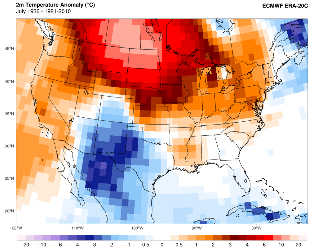
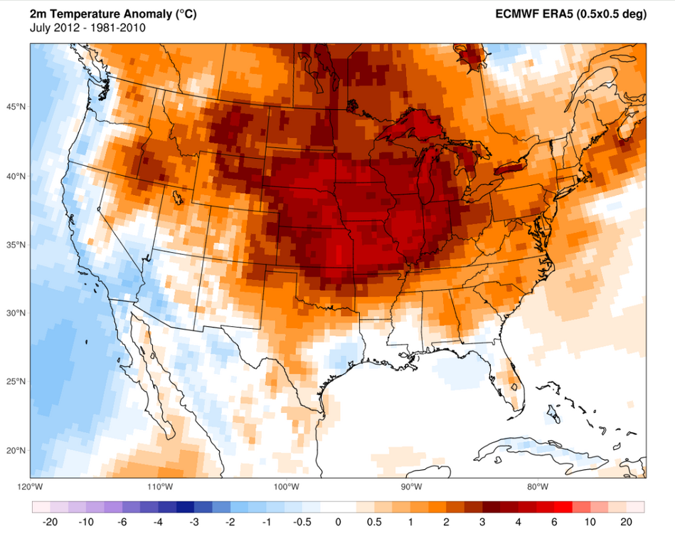
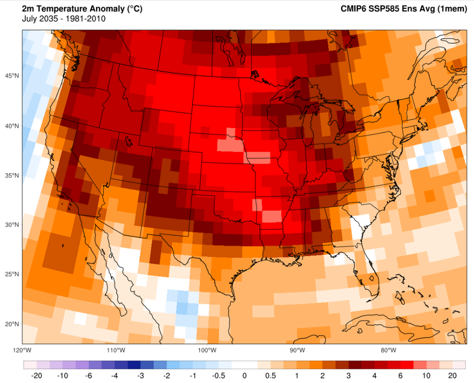
Yep. We're basically there now and the probability of it striking in any given summer has risen sharply. Going through SSP5 8.5 runs can give a feel for how bad it could get in 10-30y. For instance, it has summers occasionally far exceeding anything in the 1930s and 2012 by the *middle of next decade*. A few notes on that statement: While CO2 emissions are below 8.5 runs, radiative forcing and net energy imbalance is actually currently considerably *above* the 8.5 ensemble, mainly due to non-CO2 forcing being considerably above expectations -- and ECS/TCR might end up being on the hot side due to cloud feedback trends (detected by CERES). The most obvious brakes to this would be near term non-CO2 forcing slowdown, smoke aerosols (from extensive boreal burning -- seeing some of this already) and a weakening AMOC via differential hemispheric heating and a SMOC reversal (this too, may be in the early stages of happening). Regional trends are always a bear because transient climate responses can destructively or constructively interfere with the background trend and each other. A good example of this recently has been northern CONUS cooling in Feb-May due to a downstream response from rapid NPac cooling and cooling over the Corn Belt and adjacent areas from extensive evapotranspiration in Jun-Aug that has exchanged increased humidity for lower summer temps. These are transient responses -- and could and probably will unravel as the NHem temp response increases. Perhaps more importantly, one striking feature in future runs is the ever-present ability of intra-seasonal and intra-annual forcing to temporarily overwhelm and unravel those transient responses and result in an explosive, high volatility move that seems to come from nowhere and create conditions that seem to detach completely from the existing probability curve. The damping is removed and, like a coiled spring, the "true PDF" is revealed. These will tend to cause the most damage because of their inherent year-to-year unpredictability. A CMIP-6 run shows an example what that might look like (July 1936 and July 2012 are thrown in for good measure here): Far more extreme events in general start to occur as the NHem circulation is disrupted by the permanent collapse of summer sea ice in the late '30s-40s and by the time we hit 2050 we open up "lights out" events where temps and precipitation could destroy the existing plant stock and most of those year's crops. Events so intense and long that we could see our first "year without a winter".

-
July 2025 Obs/Disco ... possible historic month for heat
ineedsnow replied to Typhoon Tip's topic in New England
86/66 -
Will be interesting to watch.
-
July 2025 Obs/Disco ... possible historic month for heat
ineedsnow replied to Typhoon Tip's topic in New England
Heights getting pushed back down at the end of the run.. we take -

July 2025 Obs/Disco ... possible historic month for heat
DavisStraight replied to Typhoon Tip's topic in New England
87/72, nasty out there today -
Interesting, thought it be higher up my way.
-
I already gave the JMA credit for seeing the record TNH pattern for the 13-14 winter.

-
Convection and showers already moving North in the Southern most extent of the area.
-
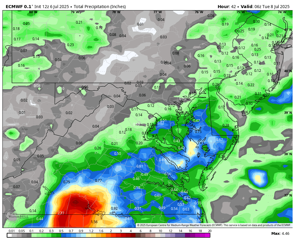
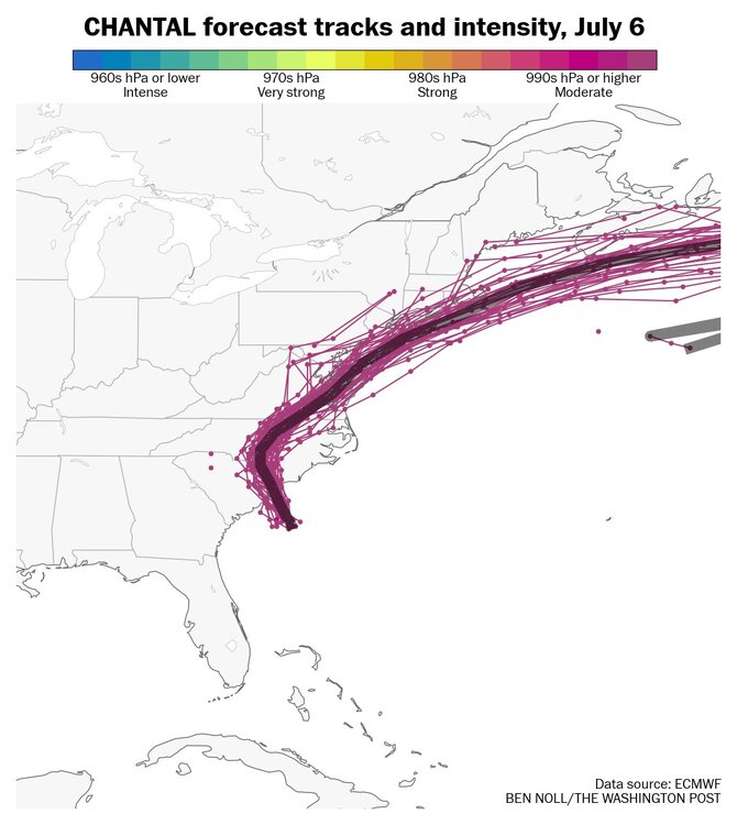
WB 12Z EURO with rain totals through early Tuesday from remnants of Chantal.

-
Most recent Ray that what I was trying to say