All Activity
- Past hour
-
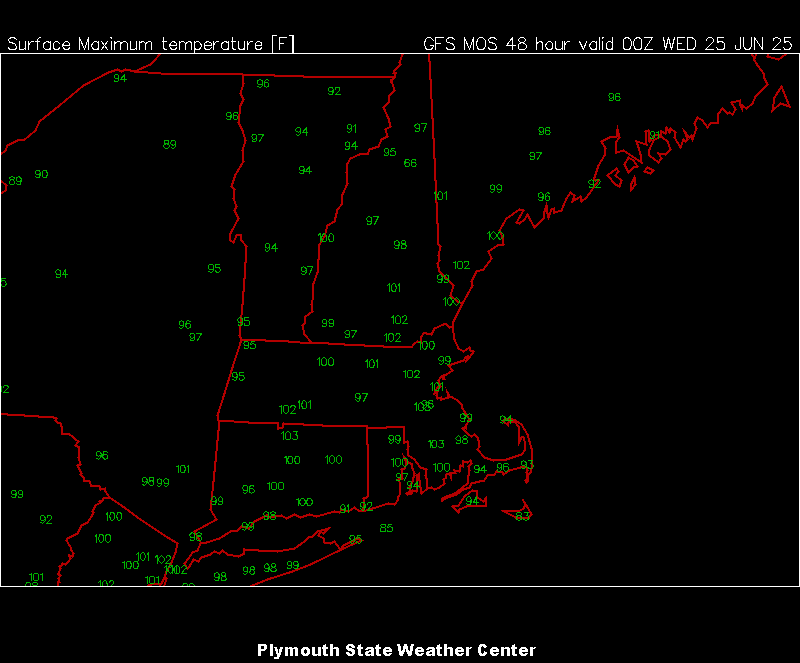
HRRR has mid 90s for the island before the sea breeze kicks in in the early afternoon. The NAM doesn't even have Islip hitting 90 today, that will horribly bust lol
-

2025 Atlantic Hurricane Season
BarryStantonGBP replied to BarryStantonGBP's topic in Tropical Headquarters
Looking like shit now 00z CMC has what appears to be a retrograding weak low off of the FL panhandle in about 8 days. -
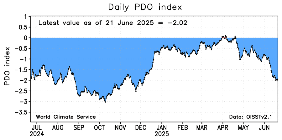
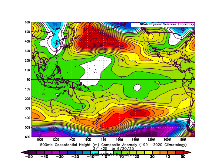
The record breaking Aleutian Ridge continues to warm the SSTs below leading to these persistent -PDOs again dropping back under -2.00. So the net effect is a record Southeast Ridge like we are seeing this week near 600 dm. This is what is driving such a strong La Niña background pattern. So there is probably a feedback process leading to the record warm subtropical SSTs. The RONI would be much lower if we subtracted the Nino 3.4 tropical SST departures from the subtropical.
-
Only managed a low of 65. The forecast was for 63. looks like a beaut in store today before tomorrow’s mild-up. Progged high today is 80.
-
RECORD EVENT REPORT NATIONAL WEATHER SERVICE NORTHERN INDIANA 205 AM EDT MON JUN 23 2025 ...RECORD WARM MINIMUM TEMPERATURE SET AT SOUTH BEND FOR JUNE 22ND... A RECORD WARM MINIMUM TEMPERATURE OF 77 WAS SET AT SOUTH BEND YESTERDAY. THIS BREAKS THE OLD RECORD OF 74 SET IN 2024 AND 1988.
-

June 2025 discussion-obs: Summerlike
LongBeachSurfFreak replied to wdrag's topic in New York City Metro
It’s all going to come down to wind direction for the coast today. EWR is a lock for 100 coming of a low of 82. -
Interesting. Could definitely be playing a role in the strong +NAO winter tendency we’ve been seeing for years now. Besides the +AMO, I also think arctic sea ice and climate change have a hand in it too
-
You know the airmass is record warm when we hit a record high here in Southern CT yesterday with the sun coming out late. RECORD EVENT REPORT NATIONAL WEATHER SERVICE NEW YORK, NY 433 PM EDT SUN JUN 22 2025 ...RECORD DAILY HIGH TEMPERATURE SET AT BRIDGEPORT CT... THE HIGH TEMPERATURE REACHED 93 DEGREES TODAY AT BRIDGEPORT SIKORSKY AIRPORT. THIS TIES THE OLD RECORD OF 93 DEGREES, SET IN 1949. RECORDS FOR THE BRIDGEPORT CT AREA GO BACK TO 1948. ALL CLIMATE DATA ARE CONSIDERED PRELIMINARY UNTIL REVIEWED BY THE NATIONAL CENTERS FOR ENVIRONMENTAL INFORMATION (NCEI).
-
78/74, just nasty
-
Not sure how anyone can enjoy this weather.
-

2025 Spring/Summer Mountain Thread
Met1985 replied to Maggie Valley Steve's topic in Southeastern States
Asheville airports normal is 84 and 63 currently. We will only be able 5 degrees above normal this week and we will be hitting right at normal for lows. Actually my current temp is 59. -
MAV/MET update

- Today
-
 75 currently(most likely our low) Lets climb baby!
 -
100F or bust today
-
Highly urbanized locations have not dropped below 80. Very steamy.
-
 Highly urbanized locations have not dropped below 80. Very steamy night.
 -
 Low this morning Wantage NJ. 76. Dewpoint 74.
 -
77/74 at 5 am.
-
Topped out at 89F yesterday. 78F here currently.
-
2025 Atlantic Hurricane Season
BarryStantonGBP replied to BarryStantonGBP's topic in Tropical Headquarters
The sharks have to watch out -
2025 Spring/Summer Mountain Thread
Met1985 replied to Maggie Valley Steve's topic in Southeastern States
Looks like this heat wave will be short lived. Better chances of storms by Thursday and temps cooling back down to the lower 80s by the weekend. Typical summer weather. -
Still 83 at 2am here lol
-
The ham sandwich may get named: Tropical Weather Outlook NWS National Hurricane Center Miami FL 200 AM EDT Mon Jun 23 2025 For the North Atlantic...Caribbean Sea and the Gulf of America: 1. Central Subtropical Atlantic (AL90): Showers and thunderstorms continue to show signs of organization overnight with an area of the low pressure located about 500 miles east of Bermuda. Recent satellite-derived wind data also indicates the system has a well-defined surface circulation with maximum sustained winds of 30-35 mph. While environmental conditions are only marginally favorable, only a small increase in organization and persistence of the current shower and thunderstorm activity is likely to result in the formation of a short-lived tropical depression or storm, as soon as later today. By Tuesday, this system is expected to encounter less favorable environmental conditions, ending its opportunity for further development. Regardless of development, the system is forecast to move northeastward at 5 to 10 mph, remaining over the open central Atlantic. * Formation chance through 48 hours...high...70 percent. * Formation chance through 7 days...high...70 percent.
-
87% humidity and a dew of 74 Still 80F outside.
-

Chicago Weather Records Tracking
Chicago Storm replied to Chicago Storm's topic in Lakes/Ohio Valley
Chicago/O'Hare received 1.86" of precipitation on June 18th, which broke the record precipitation total for the date of 1.80" (1892).


