All Activity
- Past hour
-
Wind. That's what defeats the warm river and the heat island. 39.0 for a low here on the west side of the DC Beltway.
-
What's it going to take to get a subfreezing low at DCA in October? 15 at IAD??
-
35 was the low here. Another year I couldn’t make it to Halloween without putting the heat on. Good day to put away some outdoor stuff with the possibility of some stormy weather mid to late next week.
-
fwiw...Nov thread is up with no nuance from me.
-

Spooky Season (October Disco Thread)
dendrite replied to Prismshine Productions's topic in New England
Those are heights too…not thicknesses. Usually the 540 thickness line approximates to heights around 552, but obviously in overrunning/SWFE situations we can even go higher than that and get snow. -
35 was the low here. No frost IMBY.
-
Spooky Season (October Disco Thread)
dendrite replied to Prismshine Productions's topic in New England
6z goofus tries to start as catpaws up here next week. -

Spooky Season (October Disco Thread)
jbenedet replied to Prismshine Productions's topic in New England
Min 39 -
Spooky Season (October Disco Thread)
dendrite replied to Prismshine Productions's topic in New England
Min 37.3° Right there with KDIT -
34
-
Records: Highs: EWR: 79 (2001) NYC: 79 (1963) LGA: 78 (2001) JFK: 77 (2001) Lows: EWR: 33 (1939) NYC: 29 (1879) LGA: 37 (1962) JFK: 33 (1962) Historical: 1918: The Canadian steamship Princess Sophia carrying miners from the Yukon and Alaska becomes stranded on Vanderbilt Reef. A strong northerly gale hampers rescue attempts the day before. The ship sinks on this day, killing the 268 passengers and 75 crewmen on board. 1921 - A hurricane with 100 mph winds hit Tampa, FL, causing several million dollars damage. (David Ludlum) 1921: A devastating category 3 hurricane struck near Tarpon Springs, Florida. The storm caused 8 fatalities and is the latest in the calendar year a category 3 hurricane or stronger made landfall in the US. 1925: An F2 tornado moved though Woburn and Stoneham, MA, killing 1 person, injuring 6 others, and unroofing or damaging 75 buildings. This is the strongest tornado on record for so late in the year in New England. (Ref. AccWeather Weather History) 1933: Boston, Massachusetts recorded the highest average one minute wind velocity from the northwest at 63 mph for October. (Ref. NOAA Boston Weather Events) 1965: Once again, Fort Lauderdale is deluged with heavy rain for the second time in two weeks. 13.81 inches of rain falls in a 48 hour period. Many places were flooded for the second time. (Ref. AccWeather Weather History) 1972: A storm from the Gulf of Mexico moved across North Florida, before striking Charleston and moving up the Appalachians. Very heavy rains of four to eight inches drenched areas around Norfolk, with the 6.29" on the 24th at Norfolk setting a daily rainfall record. (Ref. Late Nineteen Century Hurricanes) 1975: GOES-1, which was launched on October 16th. 1977 - Dutch Harbor in Alaska reported a barometric pressure reading of 27.31 inches (925 millibars) to establish an all-time record for the state. (The Weather Channel) 1981 - A northbound tornado caused two million dollars damage to Bountstown, FL, in less than five minutes. Fortunately no deaths occurred along its six mile path, which was 30 to 100 yards in width. Radar at Apalachicola had no indication of a tornado or severe weather. (The Weather Channel) 1982: A major coastal storm brought high winds to the Mid Atlantic, where winds gusted to 82 mph at the Chesapeake Bay Bridge Tunnel. Mt. Pisgah, NC picked up 11 inches of snow. (Ref. AccWeather Weather History) 1987 - A storm system moving across the Saint Lawrence Valley produced 40 to 50 mph winds east of Lake Ontario. High winds downed some trees around Watertown NY, and produced waves seven feet high between Henderson Harbor and Alexandria Bay. Mason City IA and Waterloo IA tied for honors as cold spot in the nation with record lows for the date of 19 degrees. Severe thunderstorms in Oklahoma and northern Texas produced golf ball size hail and wind gusts to 65 mph. (The National Weather Summary) (Storm Data) 1988 - Severe thunderstorms erupted over northeastern Texas during the late evening producing softball size hail at Newcastle and Jonesboro. Low pressure over James Bay in Canada continued to produced showers and gale force winds in the Great Lakes Region. (The National Weather Summary) (Storm Data) 1989 - Low pressure over Nevada produced high winds in the southwestern U.S., and spread heavy snow into Utah. Winds gusted to 63 mph at the Mojave Airport in southern California. Snowfall totals in Utah ranged up to 12 inches at Snowbird, with 11 inches at Alta. "Indian Summer" type weather continued in the central and eastern U.S. Twenty cities in the north central U.S. reported record high temperatures for the date. Highs of 77 degrees at Alpena MI and 81 degrees at Saint Cloud MN were the warmest of record for so late in the season. (The National Weather Summary) (Storm Data) 1997: A major snowstorm pounded Colorado, Kansas and Nebraska through the 26th. 51 inches of snow fell at Coal Creek, CO. 4 feet of snow fell over a wide area. The Denver Broncos nearly missed their flight to Buffalo, NY because of a huge storm that had dumped nearly 22 inches of snow. Known for its snow, Buffalo was actually sunny and mild as the Broncos struggled to get to the airport. 19.3 inches of snow fell at Goodland, KS to establish a new 24 hour snowfall record. A strong north wind whipped the snow into 15 to 20 foot drifts. Most roads were impassable for several days after the snow ended. There were heavy losses to cattle. Behind the storm, some locations reported record low temperatures for the date including: Scottsbluff, NE: 6°, Denver, CO: 8° (record low maximum of 21° later tied on 10/30/1991), Sheridan, WY: 8°, Rapid City, SD: 9°, Dillon, MT: 11°, Livingston, MT: 12°, Casper, WY: 13°, Colorado Springs, CO: 15°, Pocatello, ID: 15°, Goodland, KS: 18° and Billings, MT: 18°. (Ref. Wilson Wx. History) (Ref. AccWeather Weather History) 2006: A winter storm brought heavy snowfall to Colorado Rockies. Snowfall totals of 12 to 22 inches were common over the higher terrain and 6 to 12 inches at lower levels; including Denver. Sustained winds of 20 to 30 mph with gusts approaching 50 mph at Denver International Airport pushed the snow drifts 3 to 4 feet deep. Thousands were left without power as the weight of the heavy snow snapped tree limbs on to power lines. Snowfall totals included: Aspen Springs: 25 inches, Conifer: 25 inches, Rollinsville: 23.5 inches, Idaho Springs: 23 inches, Blackhawk: 22.5 inches, Bailey: 21.5 inches, Bergen Park: 19 inches, Genesee: 18 inches, Jamestown: 18 inches, Boulder: 17 inches and Evergreen: 16 inches. Denver International Airport started as rain and a thunderstorm before changing to snow. This was after a daytime high of 70°. (Ref. Wilson Wx. History) 2017: The high temperatures in Denver, Colorado was 84 degrees. By the morning hours on the 27th, the temperature fell to 13 degrees, a 71-degree change.
-

Spooky Season (October Disco Thread)
Damage In Tolland replied to Prismshine Productions's topic in New England
Growing season continues. 38.2 -

Spooky Season (October Disco Thread)
HoarfrostHubb replied to Prismshine Productions's topic in New England
31.8F. Second time below freezing this season. interesting times ahead -
Latest Natty Blend
-
BULLETIN Tropical Storm Melissa Intermediate Advisory Number 16A NWS National Hurricane Center Miami FL AL132025 800 AM EDT Sat Oct 25 2025 ...MELISSA NEAR HURRICANE STRENGTH AND FORECAST TO RAPIDLY INTENSIFY THIS WEEKEND... ...LIFE-THREATENING AND CATASTROPHIC FLASH FLOODING AND LANDSLIDES EXPECTED IN PORTIONS OF SOUTHERN HISPANIOLA AND JAMAICA THROUGH THE WEEKEND... SUMMARY OF 800 AM EDT...1200 UTC...INFORMATION ---------------------------------------------- LOCATION...16.4N 75.0W ABOUT 160 MI...260 KM SE OF KINGSTON JAMAICA ABOUT 235 MI...375 KM SW OF PORT AU PRINCE HAITI MAXIMUM SUSTAINED WINDS...70 MPH...110 KM/H PRESENT MOVEMENT...WNW OR 290 DEGREES AT 1 MPH...2 KM/H MINIMUM CENTRAL PRESSURE...982 MB...29.00 INCHES
-
29.6 for the low here, first time into the 20's this season.
-
40 / 38 off a low of 37 here. Sunny today low 60s in the warmest spots, about the same tomorrow. Cooler close with the next threat of rain / storm later Wed (29th) into Thu (31st). Nov opens near normal / slightly cooler with trough lifting out towards the 5th/6th and perhaps a one or two day warmup in between.
-
36 here in the woods. 34-35 out in the open areas with frost on the fields.
-
6Z Euro is very similar to the 0Z with strongest again at 968 S of C Jamaica, 988 near Kingston, and sharp right turn to E tip of Jamaica exiting at 992.
-
06z EC 6 hr max G over 60MPH near NYC-NNJ coast. long ways to go but the jet features argue for a moderate impact event Wednesday night-Thursday. EC upper level difference is large. Lack of ML CAPE limits potential for SVR but if modeling continues this is going to be an impact event. No thread - just reviewing for. 12 HOUR primary event Thursday.
-
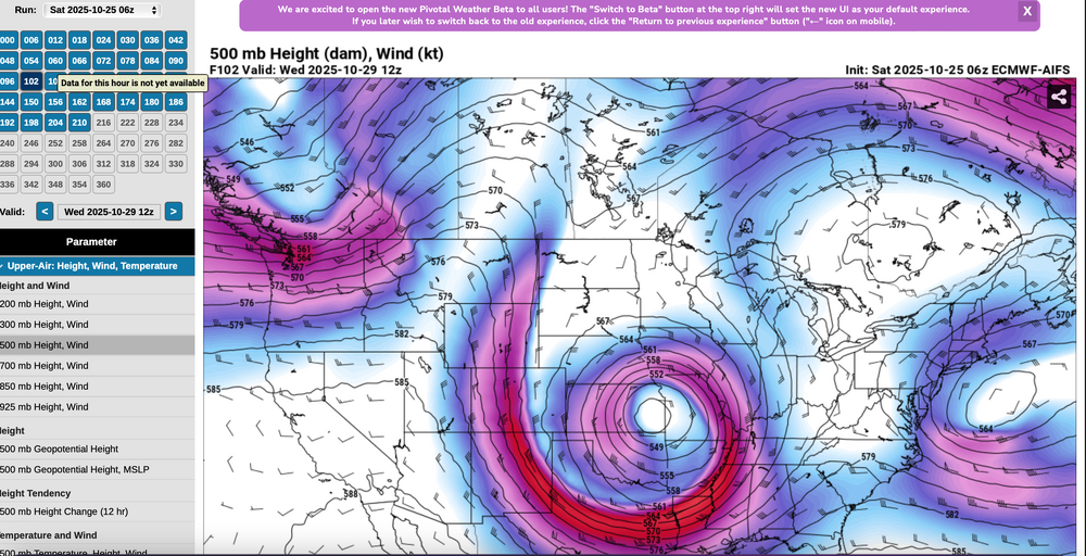
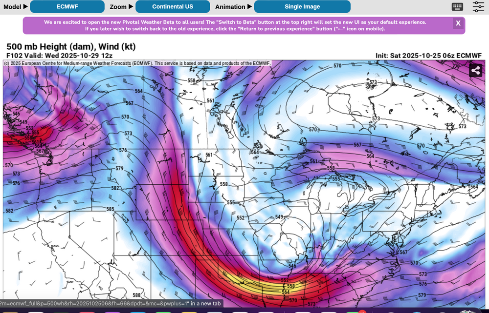
6z/25 EC and ECAI 5H at the same time - 102 hours out... note the huge difference in the ops at D4 off the east coast-New England-Great Lakes. Long ways to go to resolve what will happen.
-

Spooky Season (October Disco Thread)
kdxken replied to Prismshine Productions's topic in New England
-
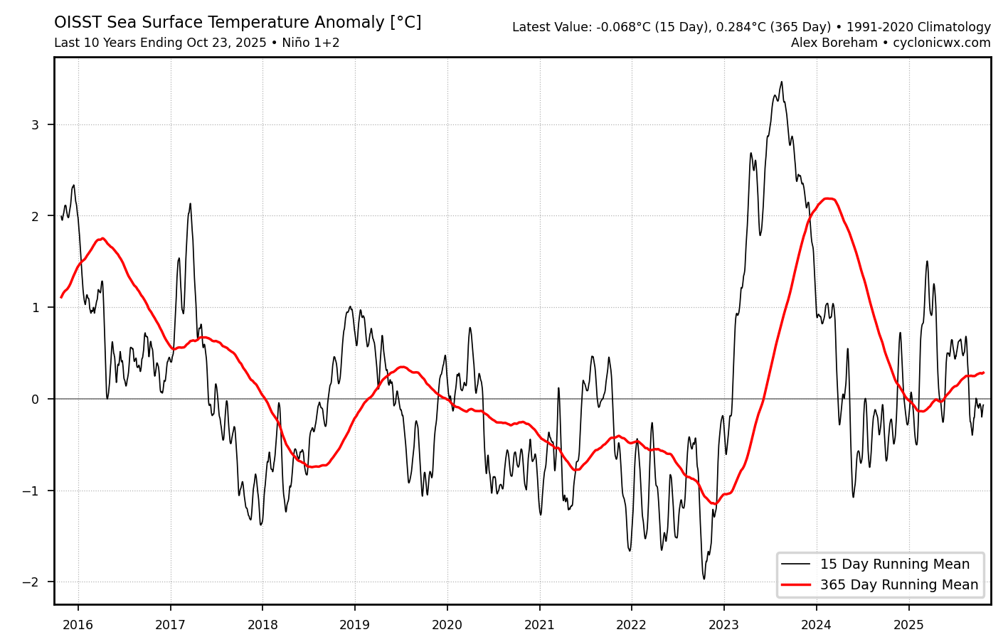
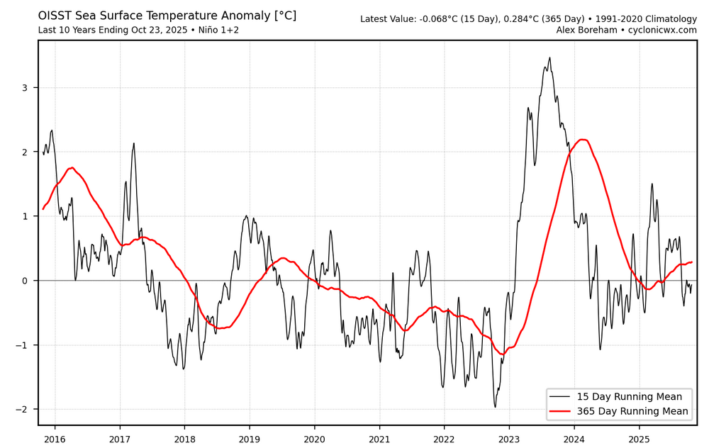
Nino 1.2 continues to run warmer than 3.4. This has been the recent theme with the EWBs not able to penetrate closer to the SA coast. It all began with the record WWB near the SA coast back in March 2023.

-
For anyone who may have saw the observation, I promise you all it’s not snowing at KMGJ, just frost, looks like the low will be 34 here.
-
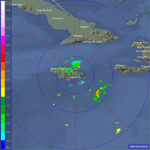
Maybe an eye showing on radar?